
7.28
Republican Climbers' and Tourists' Club
Report
- ON THE FIRST ASCENT OF THE AKSAI HORSESHOE BY A GROUP OF CLIMBERS FROM THE REPUBLICAN CLIMBING CLUB
- (March 1-8, 1959)
1959 Alma-Ata
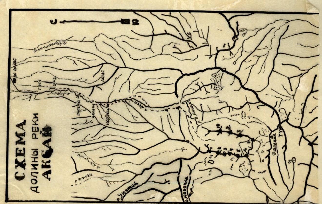
Orography of the Aksai Horseshoe Area
From the Trans-Ili Alatau ridge, a powerful Kaskelen spur branches off northwards at Peak Tur (4720 m). For the first 2 km, this spur separates the glaciers:
- Kaskelen (basin of the right tributary of the Kaskelen River),
- Shnitnikov (eastern tributary of the left Aksai River).
At Peak V. Gorbunov (4200 m), the Kaskelen spur sharply turns west and branches out, forming the Mira glacier cirque. 800 m after the branching, a beautiful rocky peak, Peak Mira (4300 m), rises above the spur's ridge, where the spur branches out again. The main ridge continues northwards, featuring 5 rocky peaks between 4200-4000 m. The last of these peaks is shaped like a rocky obelisk and is characterized by the absence of glaciation. After this peak, the Kaskelen spur descends towards a pass leading from the Left Aksai valley to the upper reaches of the Kyrgauldy River.
At Peak V. Gorbunov, the Kaskelen spur branches out. The northern, shorter branch (6-7 km) separates the western and eastern tributaries of the Left Aksai. This ridge features three rocky tower-like peaks and bears clear signs of glacial activity.
The southern boundary of the cirque of the eastern tributary of the Left Aksai is a heavily glaciated section of the Trans-Ili Alatau ridge from Peak Tur to a lateral spur. In its middle part lies the snowy Peak Shnitnikov.
East of peak (14), a spur about 8 km long branches off northwards, separating the basins of the Left and Middle Aksai. Initially, it has glaciation, and in its middle part, it features a beautiful peak shaped like a horn, "Bogdan Khmelnitsky".
The Aksai River valley:
- Does not have sharp bends,
- Stretches in a meridional direction,
- Is quite wide,
- Has well-preserved river terraces, which are convenient for roads and trails.
A detailed orography of the area is provided in the report of the research expedition to the Aksai River sources in 1954 (by M. Grudzinsky).
Brief Historical Data
Despite the proximity and accessibility of the Aksai River valley to Alma-Ata, it has been poorly explored in terms of mountaineering.
Climbers first visited the Aksai valley in 1932, when G. Beloglazov and A. Bergrin ascended to a height of 4200 m in search of the peak marked on topographic maps as height 5346 m (Peak Jolpak), and, according to their report, they found that there were no higher peaks nearby. A few years later, Moscow climbers from Professor Nemytsky's group visited this area, also searching for Jolpak, but they ascended Peak Tur (4720 m).
In 1949, a group called "Lokomotiv" conquered several peaks in Aksai. According to their report, the peak they conquered, Jolpak, has a height of 4960 m.
Such conflicting data prompted a group of climbers from the Republican Club and the Kazakh Institute of Mining and Metallurgy, led by V. Shipilov and M. Grudzinsky, to conduct a new survey of the area. This group carried out significant work to clarify the true orographic structure of the area and conquered 6 peaks. They concluded that there are no peaks in the upper reaches of Aksai exceeding 4400 m.
First Ascenders

List of first ascents in the area, including traverses:
- On peak №1 — March 4, 1959: Studenin, Vododokhov, Kuklichev, Brega
- On peak №2 — "–"
- On peak №3 — March 5, 1959: Studenin, Vododokhov, Kuklichev, Brega
- On peak №4 — March 5, 1959: Studenin, Vododokhov
- On peak №5 — March 6, 1959: Studenin, Vododokhov
- On peak №6 — May 1954: Grudzinsky
- On peaks №7, №8 — 1958: Group of military topographers
- On peak №9 — March 7, 1959: Studenin, Vododokhov
- On peak №10
- Traverse of the horseshoe March 4-7, 1959: Studenin, Vododokhov
Traverse of the horseshoe March 4-7, 1959
The task of our group, consisting of 8 people:
- Kulemin M.S. — 1st sports category, leader of the 1st group
- Mar'yashev A.N. — 1st sports category, participant of the 1st group
- Studenin B.A. — 2nd sports category, leader of the 2nd group
- Vododokhov A.A. — 2nd sports category, participant
- Kuklichev V. — 3rd sports category, participant
- Brega M.S. — 2nd sports category, participant
- Tselovakhin V.R. — 3rd sports category, senior observer
- Bolotov R.V. — 3rd sports category, observer
The task was to traverse the Aksai horseshoe and refine the orographic scheme of the area.
At noon on March 1, 1959, the group departed from Alma-Ata by car, arrived at the "Aksai" rest house, and proceeded south along the road to the forest cordon, where they spent the night.
Early the next morning, they continued on foot along the trail for 5-7 km, then put on skis. There was a lot of snow. Even on skis, they often sank up to their knees or deeper. By the end of the day, they reached the end of the forest zone and camped for the night. On March 3, they traversed the remaining distance through deep, wet, freshly fallen snow to the foot of peak №1. On the moraine, they set up a very convenient bivouac and:
- surveyed the entire ascent route,
- designated observation points for the ascent,
- prepared for the ascent.
Early on March 4, after a light breakfast, they began the ascent. The weather was clear. Initially, the path went along the lateral moraine with very deep snow, then along the talus to the rocks of peak №1.
The talus:
- is fine,
- is covered with snow on top.
It is easy to walk on.
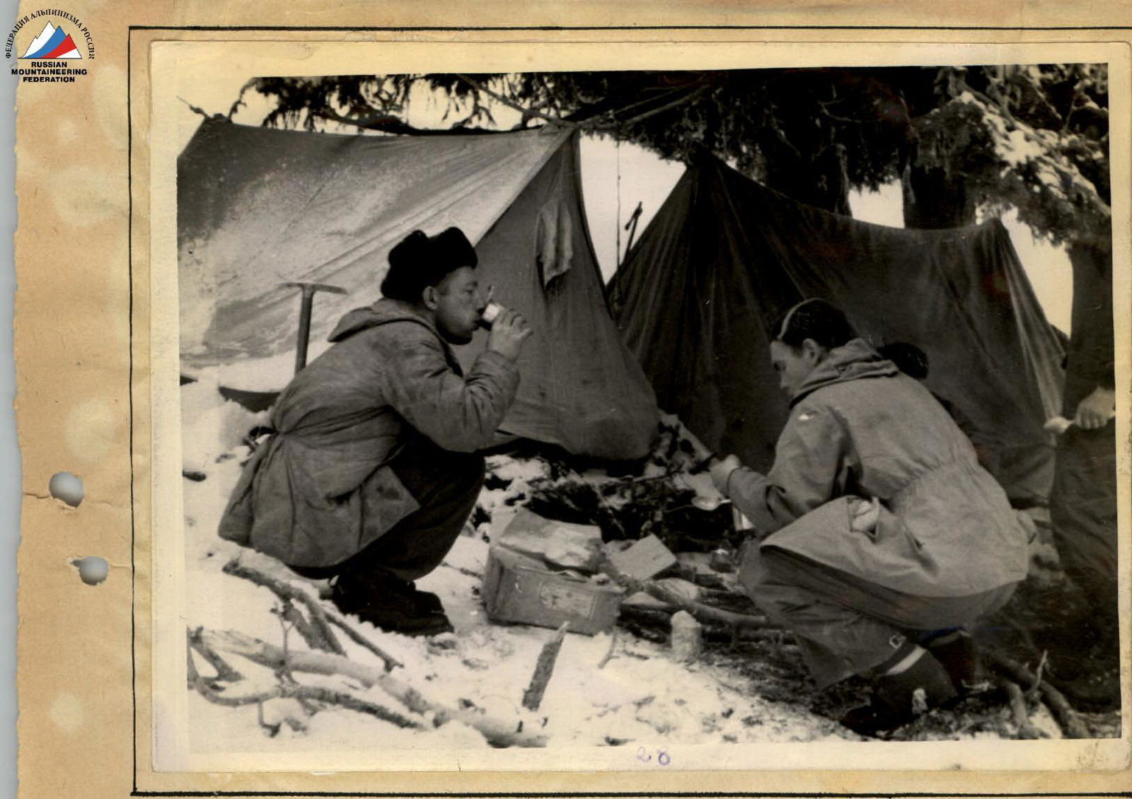 Bivouac at the end of the forest zone
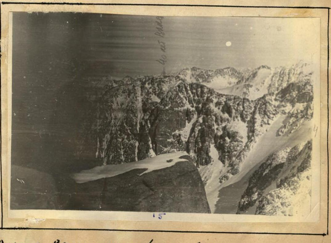 View from peak №4 towards peak №8 "40 years of VLKSM".
Special care must be taken when crossing small, weakly expressed couloirs filled with snow. Further ascent goes through destroyed easy, and then moderate difficulty rocks. Small gendarmes are relatively easily bypassed on the left, less often on the right. The exit to the pre-summit tower is via moderate and complex (two sections of 7-10 m) rocks. The ascent to the summit tower is done directly "head-on" via moderate and complex (10 m) rocks.
The ascent to peak №1 is, in our opinion, not more difficult than category 2B. The summit rocks are heavily destroyed. The southern and southwestern slopes are covered with fine and medium talus. The descent from the first peak is done directly south along the ridge. The rocks are easy and only occasionally of moderate difficulty. Small "gendarmes" are bypassed on the right, and the last 7-8-meter one is bypassed on the left via moderate rocks. Further, there are "gendarmes" both large and small, which are easily taken "head-on".
The largest "gendarme" is overcome as follows:
- initially, one should go "head-on",
- and in its uppermost part (1/3 of the height) — bypass it on the left via moderate rocks.
Between peaks №1 and №2 stands a large, double-humped "gendarme" resembling a peak. The ascent and descent from this "gendarme" are done via monolithic rocks (alaskite granites) of moderate difficulty. All saddles between "gendarmes" are covered with fine and medium talus.
The ascent to peak №2 is initially done along an easy rocky ridge. The last 100 m of the ascent are via moderate and complex (30 m) rocks with careful belaying. Further, there is a snowy slope with several steep rises leading to peak №2. The length of this section is 300-350 m.
The descent from peak №2 is done via easy rocks with talus. Then, three small "gendarmes" are easily bypassed on the right, and one is taken "head-on". The descent from the last "gendarme" is done to the left — onto a saddle.
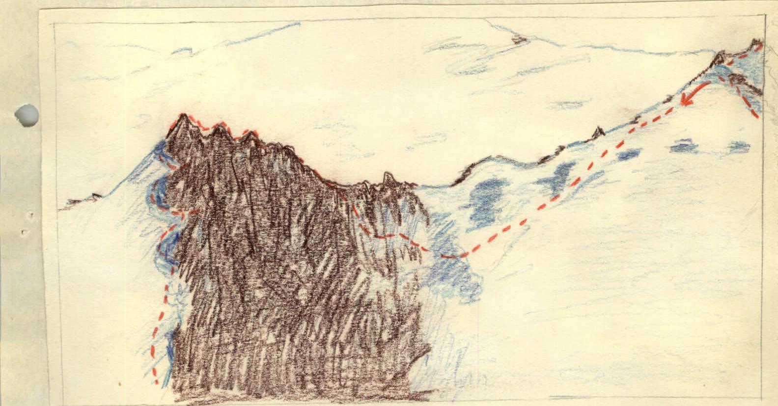
The ascent from the saddle begins by following a large (30 m) crevice (see Fig. №1), 7 m long, then via complex rocks, we exit onto the ridge. Until the very summit, there are initially moderate (10-15 m) rocks, and further — easy ones, which are traversed without the use of hands.
The cairn on peak №3 is built slightly south of the highest point because the summit itself has very inconvenient sharp rocks on which it is difficult to place a cairn.
We descend from peak №3 along a heavily destroyed, несложному ridge. Then, there is a 200-meter drop. The descent is initially via moderate, and then complex rocks with two 30-meter rappels. The rocks on top are heavily weathered, and near the saddle — monolithic (orthoclase granites). The saddle is short and heavily snowed.
A characteristic feature of this section and further to Peak Mira is as follows:
- the peaks and pre-peaks are composed of heavily destroyed rocks, very easy to pass;
- sections of rocks immediately adjacent to short saddles are near-vertical;
- there are many holds visible from afar, but using them is very difficult because they are small ledges inclined towards the climber.
The ascent from the saddle is done via moderate and complex rocks with piton belay (it is necessary to hammer in 3-4 pitons) to a small tower, bypassing it on the right via moderate rocks, and exiting onto peak №4. The peak is represented by heavily destroyed rocks.
The descent goes along a:
- gently sloping,
- heavily destroyed rocky ridge.
 On peak №5
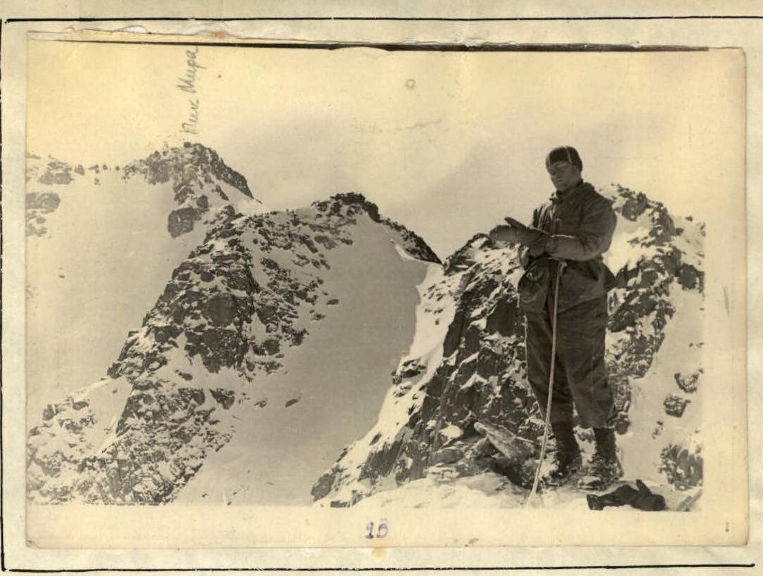
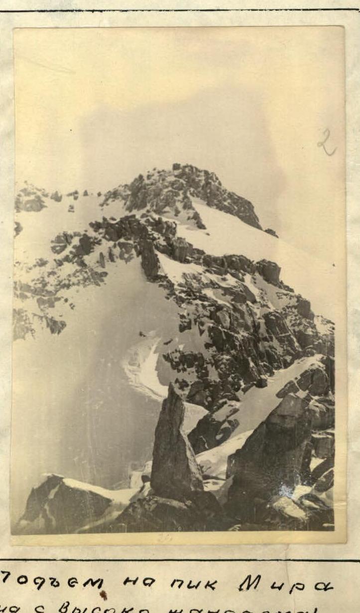 Ascent to Peak Mira (view from a high gendarme)
It is followed by a 1150-meter drop. The descent is initially via moderate, and the last 40-50 m via complex monolithic rocks with a rappel. On the rocks, there are, albeit very rare, ledges to accommodate a group. It is best to traverse this route in a small, mobile group.
The saddle is small but convenient for rest. The ascent to the next peak begins via heavily snowed moderate rocks to the ridge. The tower is easily bypassed on the left via moderate rocks.
The descent to the next (120 m) drop is initially via moderate rocks, and then complex ones with a rappel on one rope and a pendulum (20 m). The last 30 m before the saddle are completely vertical and dangerous to rappel. It is necessary to bypass on the right via moderate rocks, losing 100 m of height.
The ascent to the saddle is done via a wide, very steep couloir. The ascent to peak №5 is the most difficult section of the traverse. The first 30-32 m to a convenient ledge for receiving backpacks are completely vertical. There are many holds, but only a few can be used because the others are small, smooth ledges inclined towards the climber.
Here, it is necessary:
- To hammer in at least 8 pitons (there are enough cracks for this).
- It is impossible to climb even with a light backpack.
- Backpacks are best pulled up to the aforementioned ledge: they must be attached to a separately protruding "tooth" (Fig. №2).
After this ledge, one has to move to the right because directly above the ledge, there are overhanging vertical walls 5-7 m high (it is impossible to climb straight up with pitons). The path to the right along an inclined ledge is relatively simple, but after it — there are 5-7 m of vertical walls, the first 2-2.5 m of which have a slight overhang. One must pass in the area of a small corner where there are several insignificant footholds. Here, we hammered in (over 5-7 m) 6 pitons to ensure safety and create additional footholds.
Further, there are moderate rocks (about 100 m) leading to a large tower. The tower is traversed via a system of small but, in good weather, quite sufficient ledges for a group to pass:
- First, we go up and to the right along a ledge for 5 m;
- Then to the left (10-12 m);
- And "head-on" via vertical but with good holds, narrow ledges (3 m) — and exit onto the ridge, represented by heavily destroyed easy rocks.
The overall ascent from the saddle — in terms of distance — is 170-180 m, and the height gain is 100-220 m. More than 5 hours were spent on the ascent from the saddle to peak №5.
The descent from peak №5:
- On a piton via a heavily destroyed wide ridge;
- Then 60 m (2 ropes) via moderate rocks;
- The last 35 m — via a steep (70-75°) couloir filled with snow (snow only remains in negative micro-relief forms) — traversed in a sports manner.
Further, there is a 20-meter convenient saddle. The ascent from the saddle:
- Via moderate rocks (30 m);
- Via complex rocks (30 m, with 5 pitons hammered in) — we exit onto an easy, heavily destroyed ridge.
On the ridge, there are many large, smooth stones in the shape of parallelepipeds, 2 to 15 m high. They are bypassed:
- Initially on the left;
- And after a small saddle — on the right via an ice-snow slope with a steepness of up to 65°, adhering to the rocks. Here, 2 ice pitons were hammered in.
The exit to the first gendarme is via snow and moderate rocks (40-45 m).
Further:
- A small descent via steep rocks and snow;
- Then a 70-80-meter ascent via a steep, weakly expressed snow cornice;
- Then a 20-meter ascent via moderate rocks — and we exit to
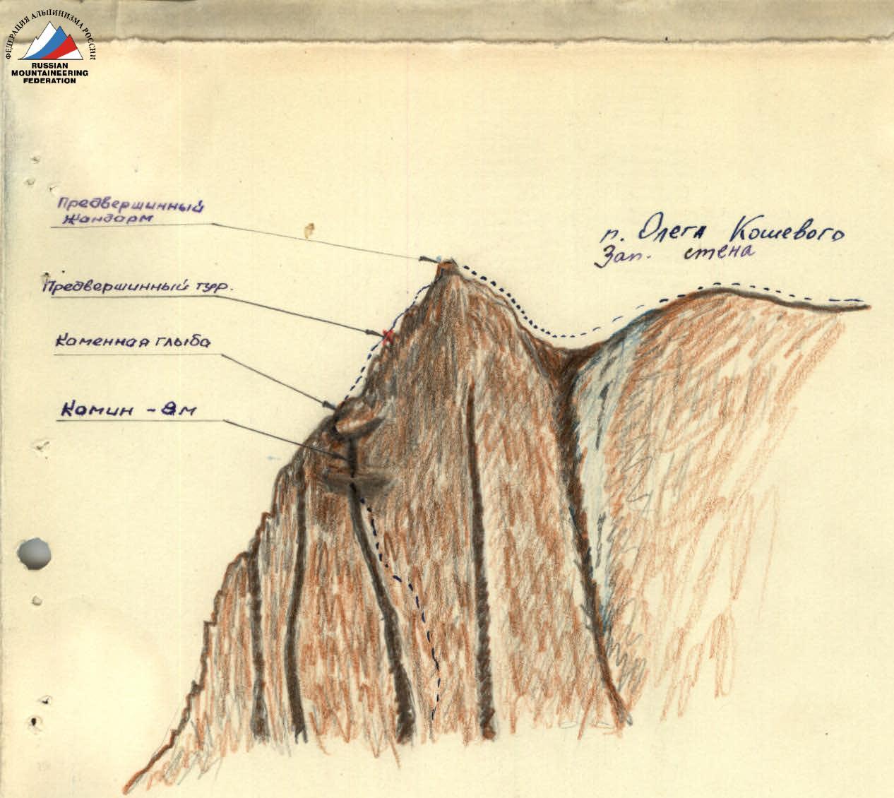
 Peak Chekrak (left) and the main peak Koshevoy
Comments
Sign in to leave a comment