
ASCENT LOG
- North Tien Shan, Trans-Ili Alatau, Malo-Almatinsky spur
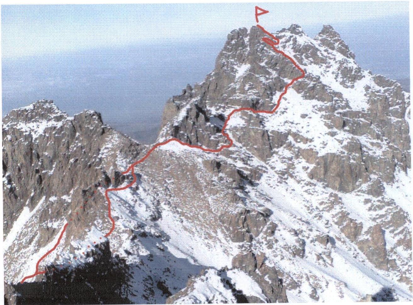
- Peak Abay (4010 m), South Ridge
- Cat. 1B diff.
- Route type — rocky
- Route elevation gain — 70 m. Route length — 550 m. Length of sections: Cat. V diff. — none.
Average steepness:
- main part of the route (sections R9–R11, R16) — 75°
- entire route — 30°
- Pitons left on the route: total — 0, bolted — 0
Pitons used:
| Rp | Bp | Cd | Camming Dev. | Fr | |
|---|---|---|---|---|---|
| Belay | 0 | 0 | 0 | 3 | 2 |
| ITO | 0 | 0 | 0 | 0 | 0 |
- Team's climbing hours on the route: 1 h 30 min
- Participants: Urubko Denis — CMS (Candidate for Master of Sports), Skopin Artem — 1st sports category
- Team coaches: Ilyinsky E.T. — Honored Coach of the USSR
- Approach to the route: December 31, 1996 — 12:00. Summit: December 31, 1996 — 13:30. Descent to Base Camp: January 1, 1997 — 16:30.
View of Peak Abay from the South, from the summit of Amangeldy
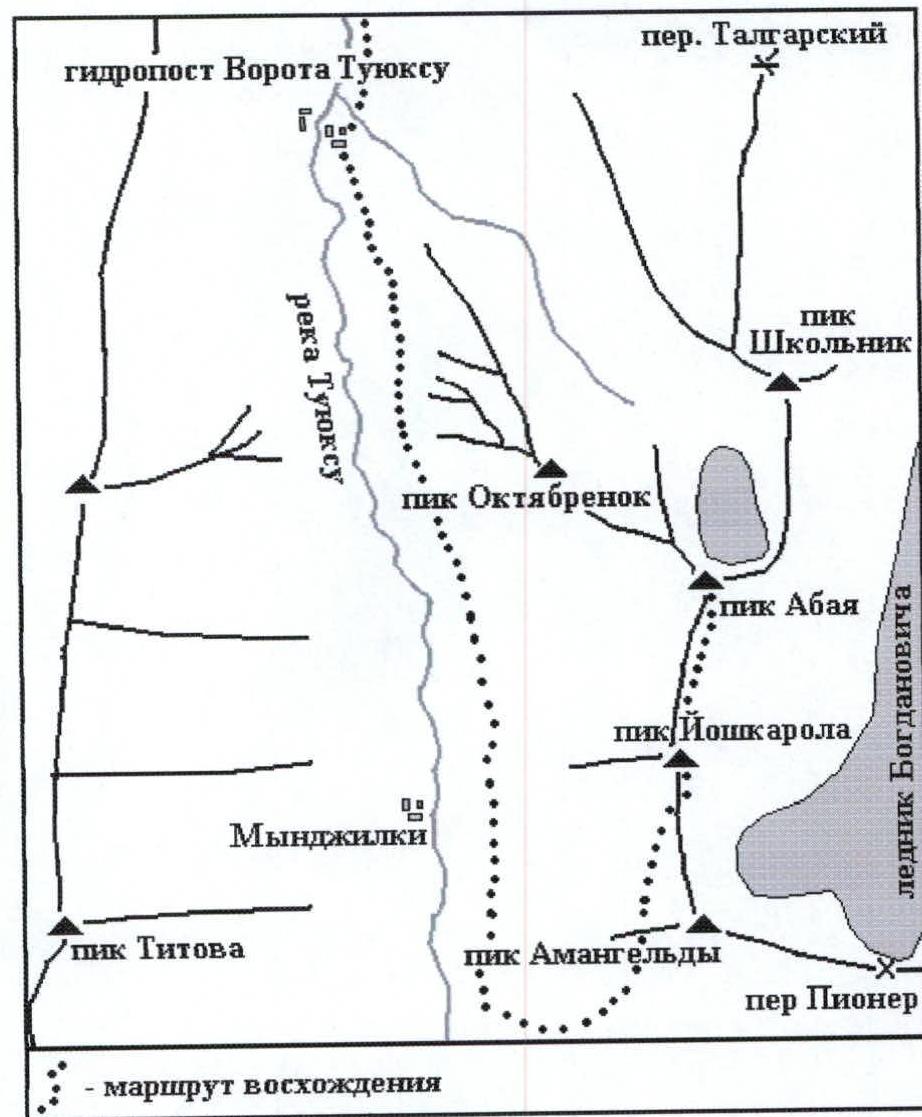
Ascent area map
South Ridge, Cat. 1B, rocky
From the road behind the Mynzhilki weather station, a trail leads left along the old moraine ridge to Alpengrad.
From here, ascend northeast along the trail towards Peak Amangeldy. Before the last narrow couloir, turn left and traverse north along the talus to the shoulder of Peak Yoshkar-Ola (4 hours).
From here, head north towards Peak Abay, mostly along the rocky ledges on the eastern side of the ridge.
Route section in UIAA symbols
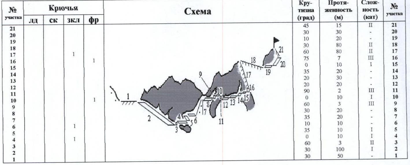
| Section # | Rp | Bp | Cd | Camming Dev. | Fr | Steepness (deg) | Length (m) | Difficulty (cat) |
|---|---|---|---|---|---|---|---|---|
| 21 | 45 | 15 | 2 | |||||
| 20 | 30 | 30 | ||||||
| 19 | 10 | 20 | ||||||
| 18 | 30 | 80 | 2 | |||||
| 17 | 1 | 60 | 80 | 2 | ||||
| 16 | 1 | 75 | 7 | 3 | ||||
| 15 | 0 | 10 | 1 | |||||
| 14 | 35 | 20 | ||||||
| 13 | 20 | 30 | ||||||
| 12 | 20 | 20 | ||||||
| 11 | 90 | 2 | 3 | |||||
| 10 | 0 | 10 | 1 | |||||
| 9 | 60 | 3 | 3 | |||||
| 8 | 30 | 20 | ||||||
| 7 | 1 | 35 | 20 | |||||
| 6 | 10 | 10 | ||||||
| 5 | 35 | 10 | ||||||
| 4 | 0 | 10 | 1 | |||||
| 3 | 60 | 3 | 2 | |||||
| 2 | 30 | 100 | 1 | |||||
| 1 | 30 | 50 |


