Ascent Passport
-
Ascent category — rock
-
Region — Western Sayan, Ergaki ridge.
-
Dinosaur Peak 2221 m via the left part of the NW wall.
-
Category — 5B first ascent. (2 ascents — Fedorov + 3 2001)
-
Route characteristics: height difference — 470 m total length — 560 m, length of sections with 6th category of difficulty — 260 m, 5th category of difficulty — 170 m. Average steepness: total route — 65°, main part: 75°
-
Equipment used on the route:
| chocks | rock pitons | bolt pitons | skyhooks |
|---|---|---|---|
| 120/40 | 20 / 10 | 6 | 10 / 10 |
-
Number of climbing hours: 15 days — 1
-
Team members: Lavrinenko A.V. CMS Odessa Morozov D.V. CMS Chelyabinsk Tarnakin Yu.A. CMS Chelyabinsk Shagaeva E.M. CMS — team leader Ryazan
-
Departure date: on the route: July 9 4:30, on the summit: July 9 19:30
-
Organization: 2001
Dinosaur Peak (Western Sayan, Ergaki ridge) (north-west wall)
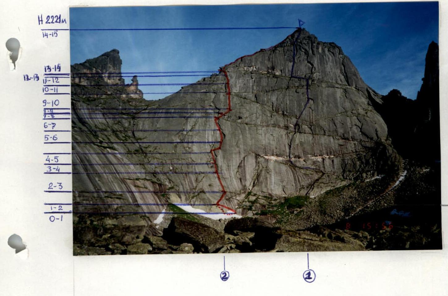
- Route through the center of the NW wall (Balezin V. 2000) 6A
- Route through the left part of the NW wall (Shagaeva E. 2001) 5B
Dinosaur Peak 2221 m via the left part of the NW wall
UIAA scheme


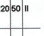

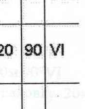
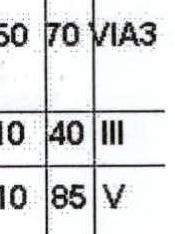
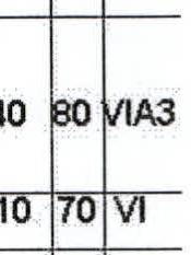
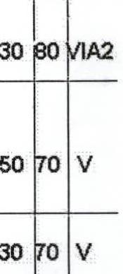
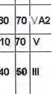
| Pitch | chocks | rock pitons | bolt pitons | skyhooks | length in meters | steepness ° | difficulty |
|---|---|---|---|---|---|---|---|
| 16 | 120 | 50 | II | ||||
| 15 | 50 | 80 | V | ||||
| 14 | 3 / 3 | 5 / 5 | 1 | 20 | 80 | VIA3 | |
| 13 | 20 | 90 | VI | ||||
| 12 | 10/16 | 3 / 3 | 1 | 50 | 70 | VIA3 | |
| 11 | 10 | 40 | III | ||||
| 10 | 1 | 10 | 85 | V | |||
| 9 | 10/10 | 1 | 40 | 80 | VIA3 | ||
| 8 | 10 | 70 | VI | ||||
| 7 | 12 / 8 | 30 | 80 | VIA2 | |||
| 6 | 10 | 1 | 50 | 70 | V | ||
| 5 | 10 | 1 | 30 | 70 | V | ||
| 4 | 1 | 1 / 1 | 10 | 30 | 70 | VA2 | |
| 3 | 3 | 1 | 10 | 70 | V | ||
| 2 | 6 | 40 | 50 | III | |||
| 1 | 2 | 40 | 40 | II |
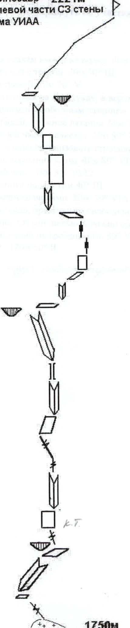
Route description by sections
R0–R1. Exit to a ledge via a snow patch and easy rocks. 40 m 40° II R1–R2. Inclined inner corner with grass. 40 m 50° III R2–R3. Crack, heavily overgrown with grass. 10 m 70° V R3–R4. Monolithic slab, climbed using skyhooks, with free climbing in the upper part. 30 m 70° VA2 R4–R5. Inner corner, climbed using free climbing. 30 m 70° V R5–R6. Diagonal crack, overgrown with grass, difficult climbing. 50 m 70° V R6–R7. Inner corner, overhanging in the upper part. 30 m 80° VIA2 R7–R8. Narrow, wet chimney. Difficult to organize protection. 10 m 70° VI R8–R9. Steep inner corner, overgrown with moss. 40 m 80° VIA3 R9–R10. Overhanging inner corner. 10 m 85° V R10–R11. Discontinuous inclined ledge. 10 m 40° III R11–R12. Slab with "deaf", overgrown cracks. 50 m 70° VIA3 R12–R13. Wide, overhanging crack, climbed using free climbing. 20 m 90° VI R13–R14. Slab, with a discontinuous "deaf" crack. Difficult to organize protection. 20 m 80° VIA3 R14–R15. Inner corner, leading to the ridge. 50 m 80° V R15–R16. Easy ridge rocks. 120 m 50° II
Control belay after the third rope.
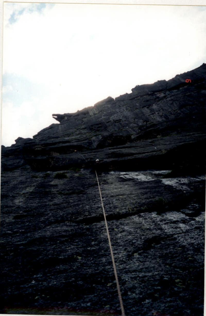
Photo 1. Team on the route (view from below)
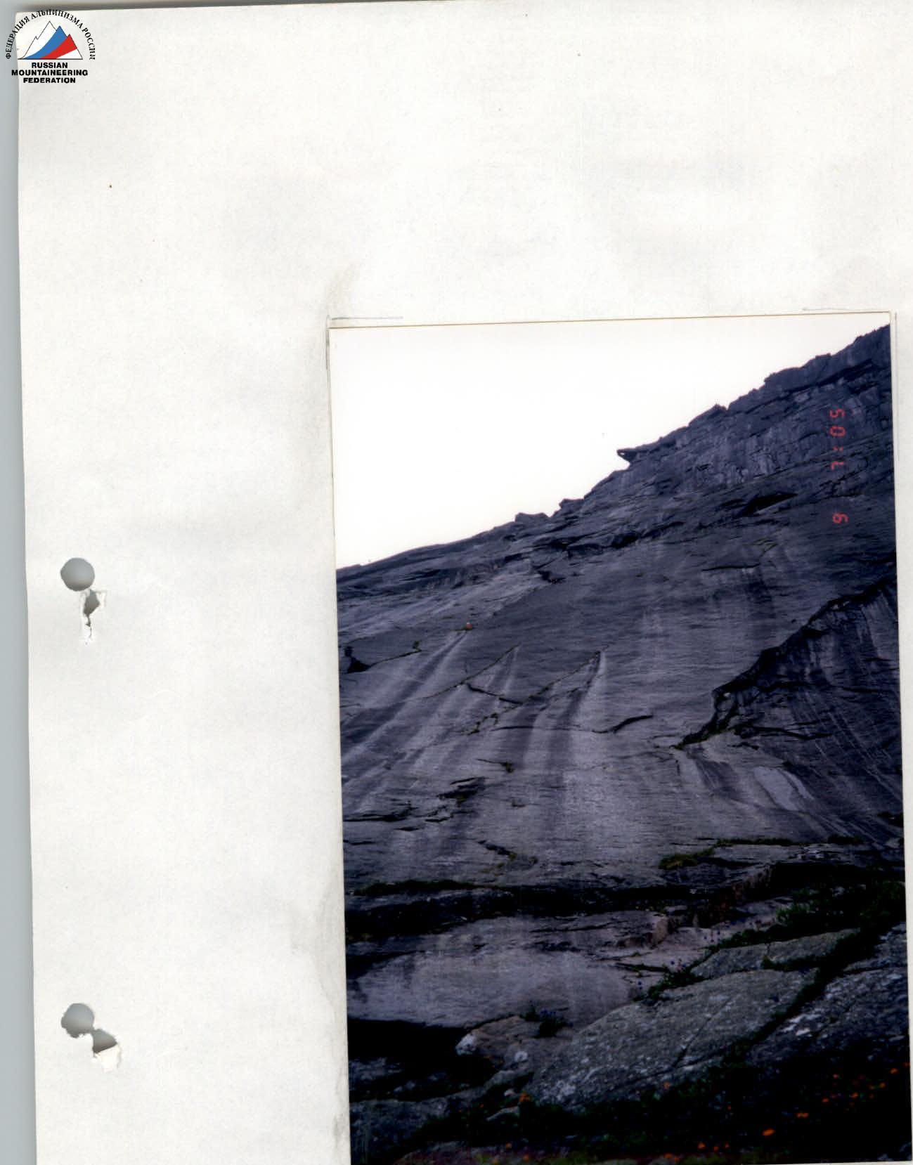
Photo 2. (View from below, from the control belay)