6.2 Western Sayan
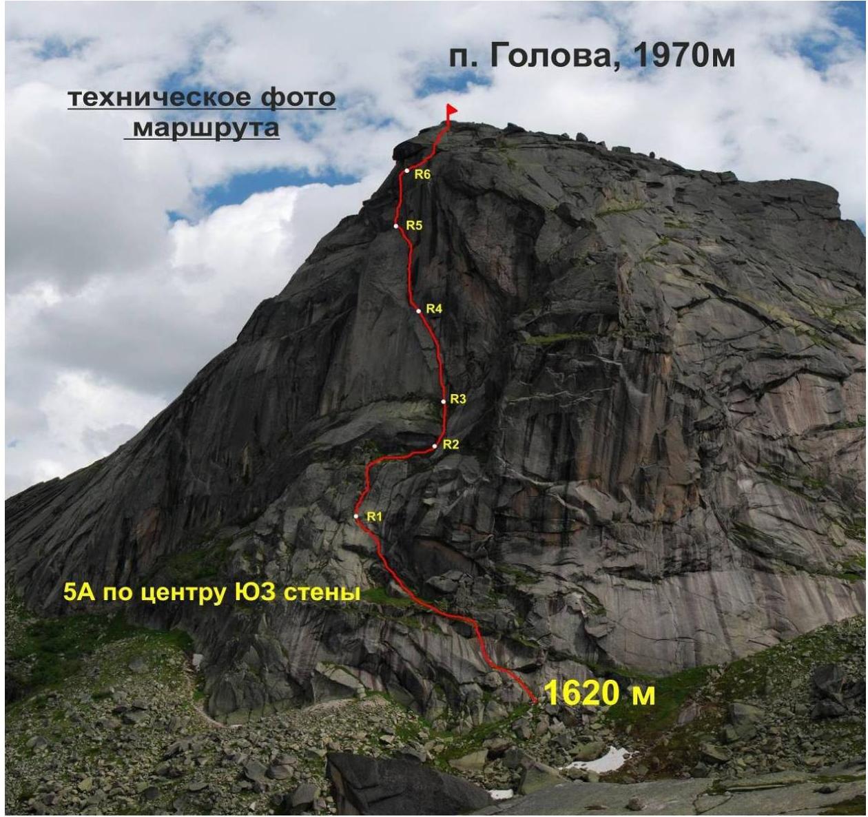
Golova, 1970 m, 5A, via the center of the SW wall Prokofiev D.E. July 10, 2013
Ascent Record
- Region — Sayan Mountains, Western Sayan
- Peak — Golova, 1970 m, via the center of the SW wall. 5A.
- Assumed — 5A category of difficulty, first ascent.
- Route type — rock
- Route description:
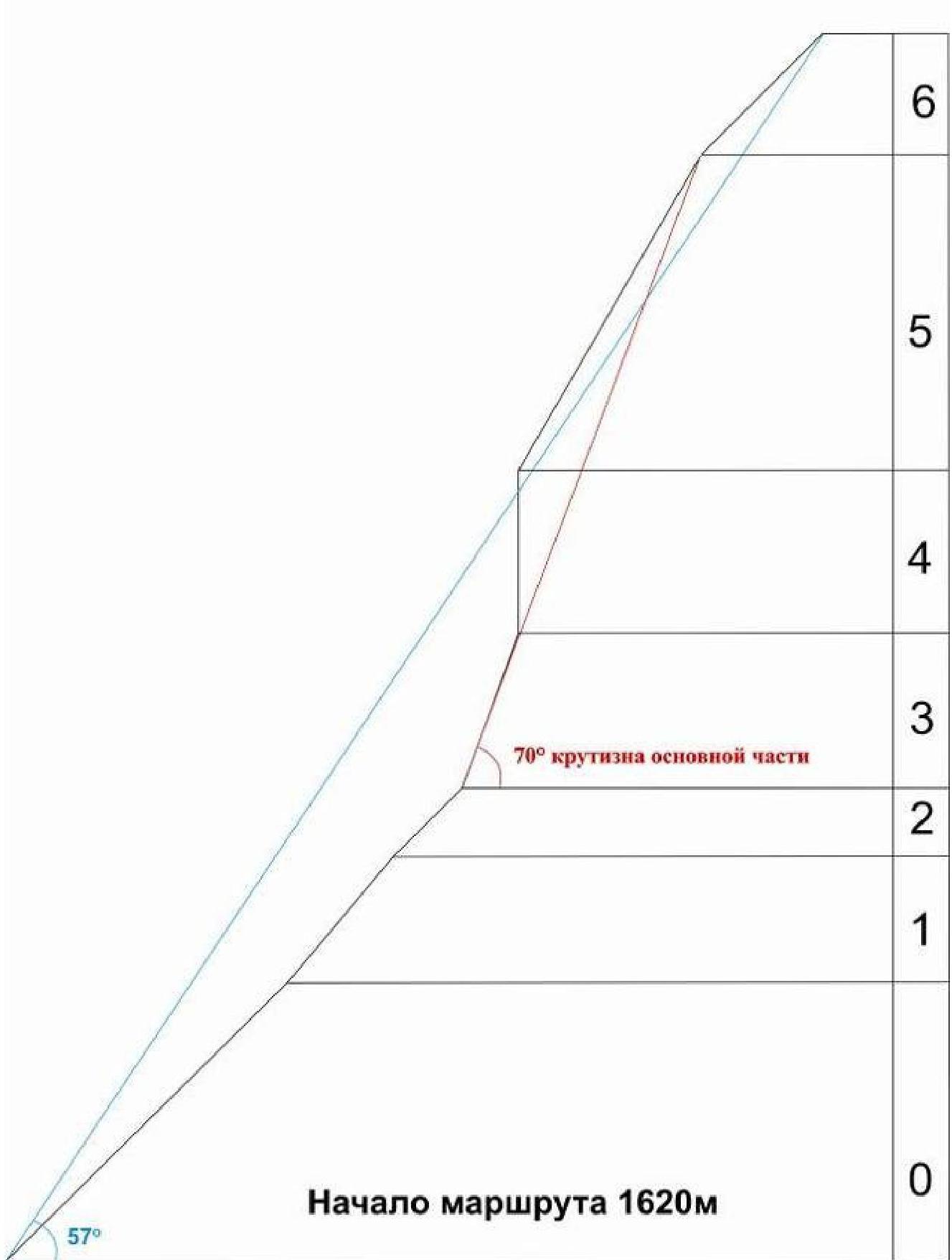
elevation gain — 350 m. route length — 445 m. length of 6th category sections — 100 m. length of 4th category sections — 345 m. average slope — 57°, main part 70°
- Equipment left on the route: total 0
Nuts used — 65, pitons used — 0, total protection used — 0
- Climbing time — 9.5 hours, duration — 1 day
- Team leader: Prokofiev Denis E. Master of Sports
Team members:
- Popova Marina E. 1st class
- Team coach:
Prokofiev Denis E. Master of Sports
-
Departure date: to the route July 10, 2013, 10:00 summit, 20:00 return, 21:30
-
Ascent organized by — Ministry of Sports, Tourism and Youth Policy of Krasnoyarsk Krai.
2013
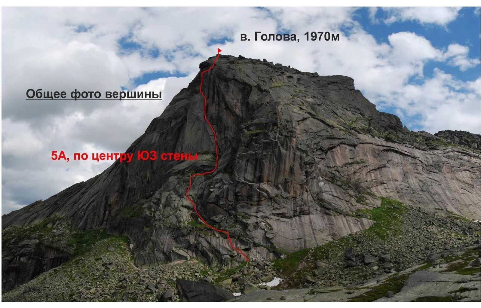
General photo of the summit 5A, center (capital's SW) v. Golova, 1970 m
 №386
№386
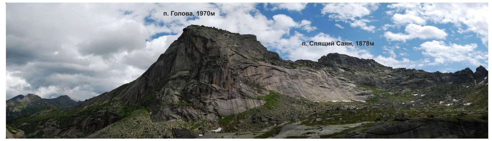
Photo panorama of the area
Brief Overview and Tactical Actions of the Team
The Golova peak is located within the Ergaki National Park, and there is a straightforward approach via a tourist trail from Raduzhnoe Lake to the Volosy Sayan (Golova) pass, category 1A.
A logical first ascent was planned via the center of the south wall, directly leading to the summit.
The team, Prokofiev D. and Popova M., departed from the "Center of Travelers" base at 10:00, as the weather was unfavorable earlier.
At 12:00, they reached the start of the route and began working on it at 12:30. By 15:00, they approached the key sections. At 20:00, they reached the summit.
The descent began at 20:30 via a multipitch route on Golova Spayushchego Sayana, leading towards Raduzhnoe Lake.
At 21:30, they descended to a rock plateau between Raduzhnoe Lake and the Golova peak, where they set up their tent.
| № | Total | Golova, 1970 m via the center of the SW wall. Assumed 5A category of difficulty | ||
|---|---|---|---|---|
| 6-7 | 3 | 0 | ||
| 5-6 | 12 | 0 |  | 110 м 60 |
| 4-5 | 9 | 2 |  | 90 |
| № | Total | |||
| --- | --- | --- | --- | --- |
| Nuts | Pitons | |||
| 3-4 | 15 | 0 | ||
| 2-3 | 6 | 0 | ||
| 1-2 | 8 | 1 | ||
| 0-1 | 12 | 3 |
IV 50 м 45°
IV 30 м 45°
IV 120 м 45°
IV 50 м 70°
Route Description by Sections
The approach from Raduzhnoe Lake takes about an hour via the trail to the Volosy (Spayushchiy Sayan) pass. The start of the route is directly from the trail — grassy ledges beginning in the right part of the southwest wall. Section R0–R1 — length 120 m, slope about 45°. Start of the route. We ascend to the grassy ledges located in the right part of the wall. Movement is on rocks left-upwards. Protection is on rocks (medium-sized nuts, pitons), intermediate station on a large good ledge. On wet rocks, movement needs to be cautious as ledges alternate with short sections of "ram's foreheads". Station at the start of a long internal angle. IV Section R1–R2 — length about 50 m. Slope 50°. The internal angle leads to a sloping long ledge, traversing right about 10 m to the start of vertical cracks. IV Section R2–R3 — movement up the cracks, exit to a ledge, then up to a vertical crack. Section about 30 m, 45°, IV Section R3–R4 — length 50 m, slope 70°. The vertical crack is climbed free (or A1), then transitions into a narrow chimney (about 10 m), climbed free, organization of protection is problematic, difficult climbing. Then movement left-upwards along the crack to a ledge. VI Section R4–R5 — key section of the route, 50 m, slope 90°. Movement to the base of a vertical chimney (about 35 m). The chimney is climbed free, protection possible only at the start and in the second third. After the chimney, traverse left to the widening of the ledge. Station. VI Section R5–R6 — length 110 m, movement along a system of ledges and cracks left-upwards, then along an internal angle under an overhang, station under it. The overhang is bypassed on the left. Then movement right-upwards along the internal angle under a large pre-summit cornice. IV Section R6–R7 — traverse under the cornice right, then exit upwards along cracks, climbed free. Exit to a ledge. On the ledge to the summit, easy climbing, about 10 m. IV
Descent: descent via a multipitch route on Golova, passing to the right of the route, also leading towards Raduzhnoe Lake.
Supplement to the Route:
The equipment used on the route was predominantly nuts and rock pitons.
p. Golova, 1970 m
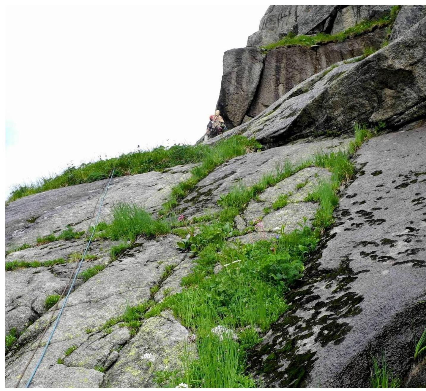
Passage of section R0–R1. Denis Prokofiev.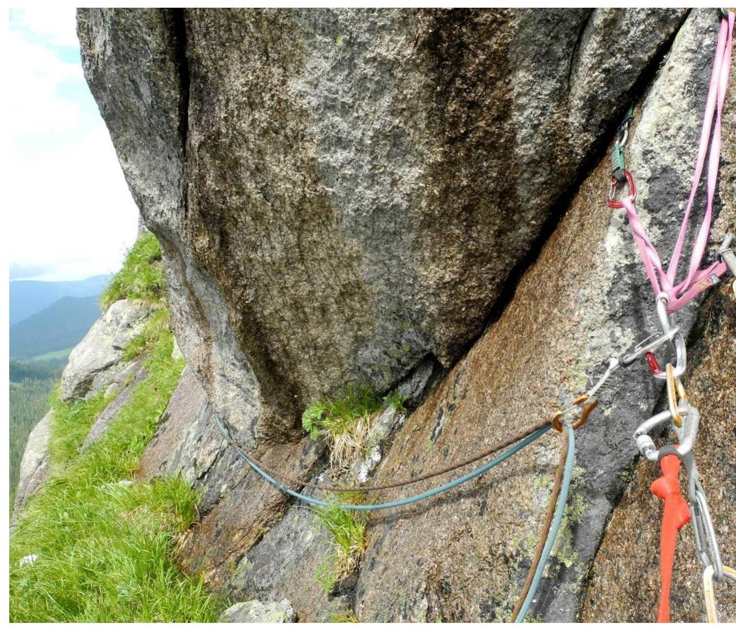
Intermediate station on R0–R1