
II. Ascent Record of Pogranichnik Zabaykalya Peak, 3601.7 m, via the Southern Slope.
- Altai, Chikhachov Ridge, section 1.7.
- Pogranichnik Zabaykalya Peak, 3601.7 m, via the Southern Slope.
- Proposed category 1B difficulty. First ascent.
- The route is of snow and ice character.
- Route characteristics:
- Elevation gain 500 m
- Length 1000 m
- Average slope angle 25°
-
Pitons used: ice screws — 1, 8: protection via ice axes.
-
Team's total climbing time 7 hours.
-
Leader: Ryzhova T.A., 1st sports category
Elevation gain 500 m, length 1000 m, average slope angle 25°. 6. Pitons used: ice screws — 1, protection via ice axes. 7. Team's total climbing time 7 hours. 8. Leader Ryzhova T.A., 1st sports category,
Team members:
- Afanasyev A.E., 1st sports category
- Kovalev G.V., 1st sports category
- Korzhov P.I., 2nd sports category
- Tenenev V.A., 1st sports category
- Khlynowski A.M., 1st sports category + 4 novices
Date of departure and return: May 15, 1978.
Description of the Ascent to Pogranichnik Zabaykalya Peak, 3601.7 m, via the Southern Slope.
The peak is located on the main watershed of the Chikhachov Ridge and, surrounded by the Pravaya Boguty and Naryn-Gol gorges, is the highest and most notable.
The approach to the route is the same as for Peak VLKSM. In our case, it followed tracks and took 1 hour.
The Pravaya Boguty cirque is branched and divided into 5 smaller cirques. Each contains from one to three lakes.
One needs to move north, straight in the direction from which they came, towards the bivouac. Along the way, two lakes are passed, which in May appear as snowfields.
In the upper part of the cirque, there is a nearly 90° turn to the left.
The approach ends below the pass from Pravaya Boguty to the Naryn-Gol source, between the peaks Pogranichnik Zabaykalya and VLKSM.
The ascent to the pass is very steep and snowy. In snow-free periods, rock outcrops are possible.
The beginning of the route is approximately at an altitude of 3100 m, below the pass.
The first two sections, leading to the pass, also coincide with the route to Peak VLKSM, but here the path has been blown away.
Section 0–1 25° 200 m I– Snowy slope in the direction of the pass, slightly to the right of the middle.
Section 1–2 40° 150 m I+ Steep snowy slope. The snow is dense. In the left part, rock outcrops resembling "ram's foreheads" are visible. Exit onto the pass ridge. Then, a 90-degree turn to the right.
Section 2–3 25° 200 m I– The ridge is wide, gentle, and talus-covered.
Section 3–4 35° 200 m I– Talus slope with snow. Leads to the summit glacier.
Section 4–5 45° 20 m II+
- The protruding belly of the glacier.
- Firnified ice.
- Three rope lengths on screw pitons, movement in crampons.
- Transition onto the "roof" of the glacier.
Section 5–6 35° 100 m I+
- Hard névé
- Protection via ice axes
Section 6–7 25° 200 m I−
- The summit slope gradually becomes gentler.
- Nasty snow that sometimes gives way
Exit onto the summit of Pogranichnik Zabaykalya 3601.7. In May 1978, the summit was gently sloping in all directions.
Descent followed the ascent route.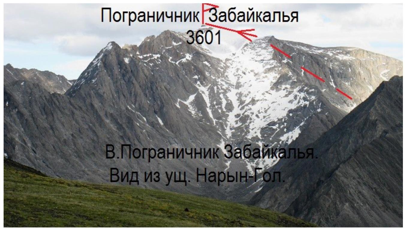
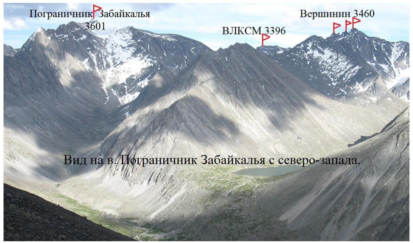
View of Pogranichnik Zabaykalya Peak from the northwest.
Comments
Sign in to leave a comment