
REPORT
ON THE FIRST ASCENT TO THE NOSOROG PEAK VIA THE CENTER OF THE SOUTH FACE ROUTE, 3rd Category of Difficulty, 5A (PRESUMABLY) BY THE "RYZHAYA" TEAM FOR THE PERIOD FROM OCTOBER 31, 2023, TO OCTOBER 31, 2023
Irkutsk 2023
I. Climbing Passport
| 1. General Information | ||
|---|---|---|
| 1.1 | Full Name, Sports Rank of the Leader, Date of Birth | Anton Vladimirovich Ivanovski, 2nd sports rank, May 25, 1988 |
| 1.2 | Full Name, Sports Rank of Participants, Date of Birth | Evgeniya Vasilievna Kazantseva, 2nd sports rank |
| 1.3 | Full Name of Coach | A.E. Afanasiev, MS, M.V. Korshunov, A.M. Panova |
| 1.4 | Organization | FASIO |
| 2. Characteristics of the Climbing Object | ||
| 2.1 | Region | Sayan Mountains, Tunkin Goltsy |
| 2.2 | Valley | Chertolen-Gorkhon |
| 2.3 | Classification Table Section Number for 2013 | 6.1.2 |
| 2.4 | Name and Height of the Peak | Nosorog 2950 m |
| 2.5 | Geographic Coordinates of the Peak (Latitude/Longitude), GPS Coordinates (1) | |
| 3. Characteristics of the Route | ||
| 3.1 | Name of the Route | via the center of the South Face, 3rd cat. |
| 3.2 | Proposed Category of Difficulty | 5A |
| 3.3 | Degree of Route Exploration | first ascent |
| 3.4 | Relief Characteristics of the Route | Rocky |
| 3.5 | Height Difference of the Route (altimeter or GPS data) | 360 m |
| 3.6 | Route Length (in meters) | 560 m |
| 3.7 | Technical Elements of the Route (total length of sections with different categories of difficulty, indicating the relief type (ice-snow, rocky)) | 1B cat. diff. rocks 50 m. 2B cat. diff. rocks 60 m. 3B cat. diff. rocks 130 m. 4B cat. diff. rocks 80 m. 5B cat. diff. rocks 40 m. 6B cat. diff. rocks 170 m. Rocks 6, A3 30 m. Descent by rappel towards the valley: first not more than 12 m, second 27 m. |
| 3.8 | Average Steepness of the Route (2) | |
| 3.9 | Average Steepness of the Main Part of the Route (2) | 70 |
| 3.10 | Descent from the Summit | Via the NC cat. diff. into the Chertolen-Gorkhon valley (via the 3rd couloir) |
| 3.11 | Additional Characteristics of the Route | |
| 4. Characteristics of Team Actions | ||
| 4.1 | Time of Movement (team's walking hours, in hours and days) | 20 h |
| 4.2 | Overnight Stays | — |
| 4.3 | Time of Route Preparation (3) | — |
| 4.4 | Start of the Route | Departure from BL at 4:00, leader's start on the route at 8:40 on October 31, 2023 |
| 4.5 | Reaching the Summit | Reached the summit at 19:04 on October 31, 2023 |
| 4.6 | Return to Base Camp | Returned to base camp at 23:45 on October 31, 2023 |
| 5. Characteristics of Weather Conditions (4) | ||
| 5.1 | Temperature, °C | –8 °C |
| 5.2 | Wind Speed, m/s | 1–2 m/s (with gusts up to 10 m/s, starting from 18:00) |
| 5.3 | Precipitation | Snow (throughout the day with short breaks) |
| 5.4 | Visibility, m | |
| 6. Person Responsible for the Report | ||
| 6.1 | Full Name, e-mail | Anton Vladimirovich Ivanovski sever1988@mail.ru |
II. Climbing Description
1. General View of Nosorog Peak from the South
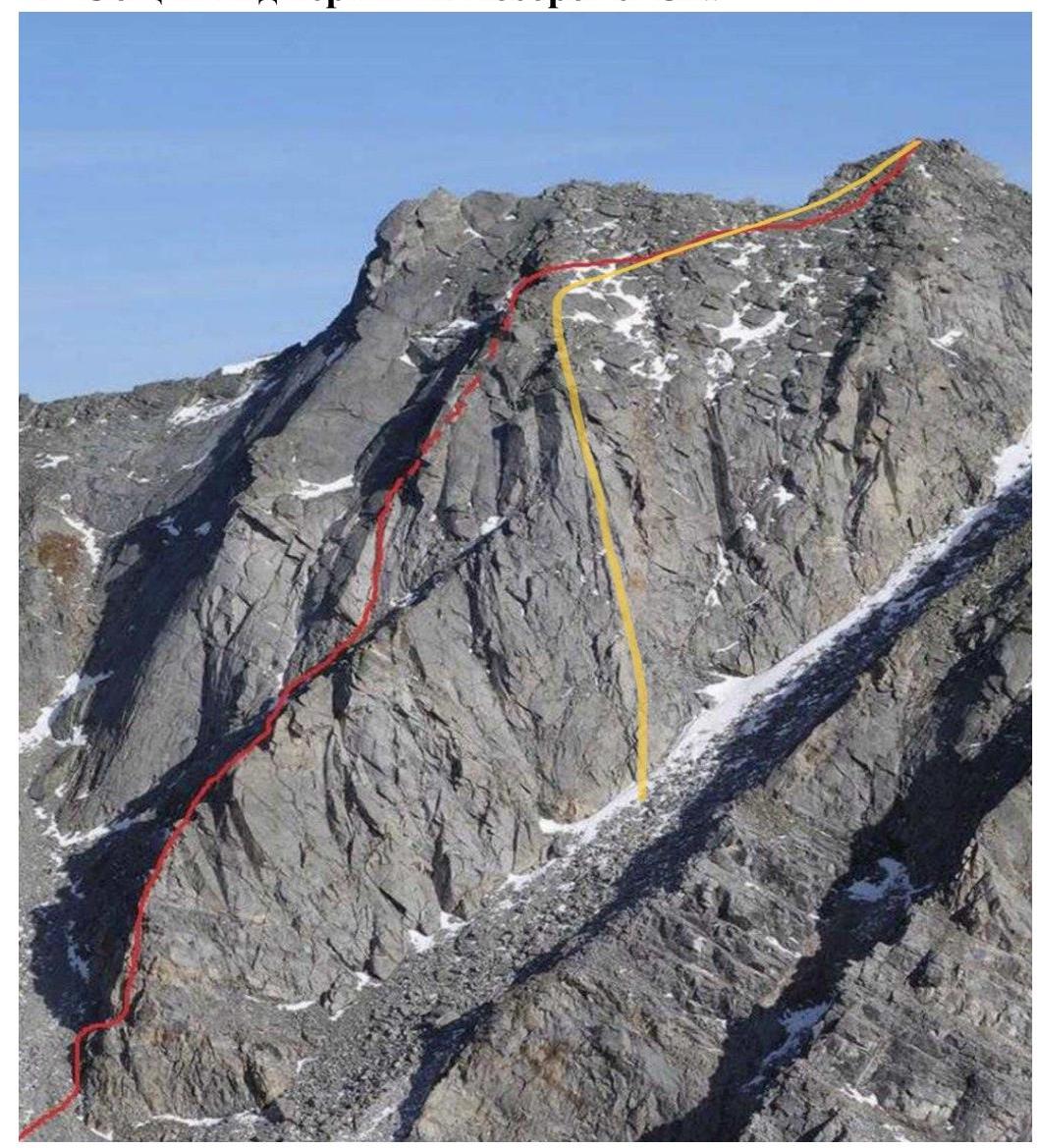
Photo 1 (October 2018). Red line — route 3B by A.A. Boyko (2018). Yellow line — route taken by the team (October 31, 2023).
2. Route Profile from the West

Photo 2 (November 2, 2023).
3. Drawn Profile of the Route with UIAA Symbols
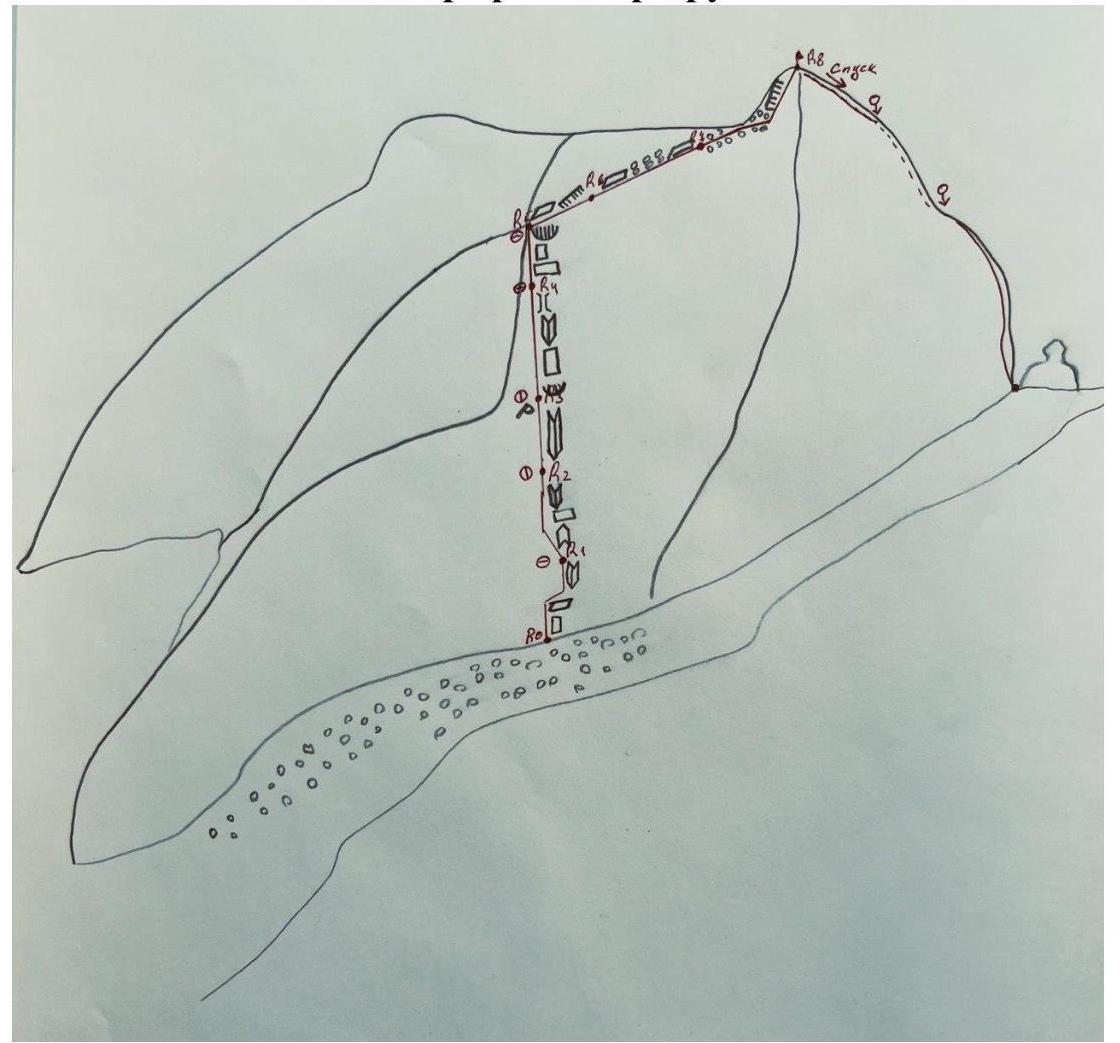
Photo 3.
4. Photopanorama of the Area with Peak Names and Heights

Photo 4 (October 2018).
5. Map of the Area
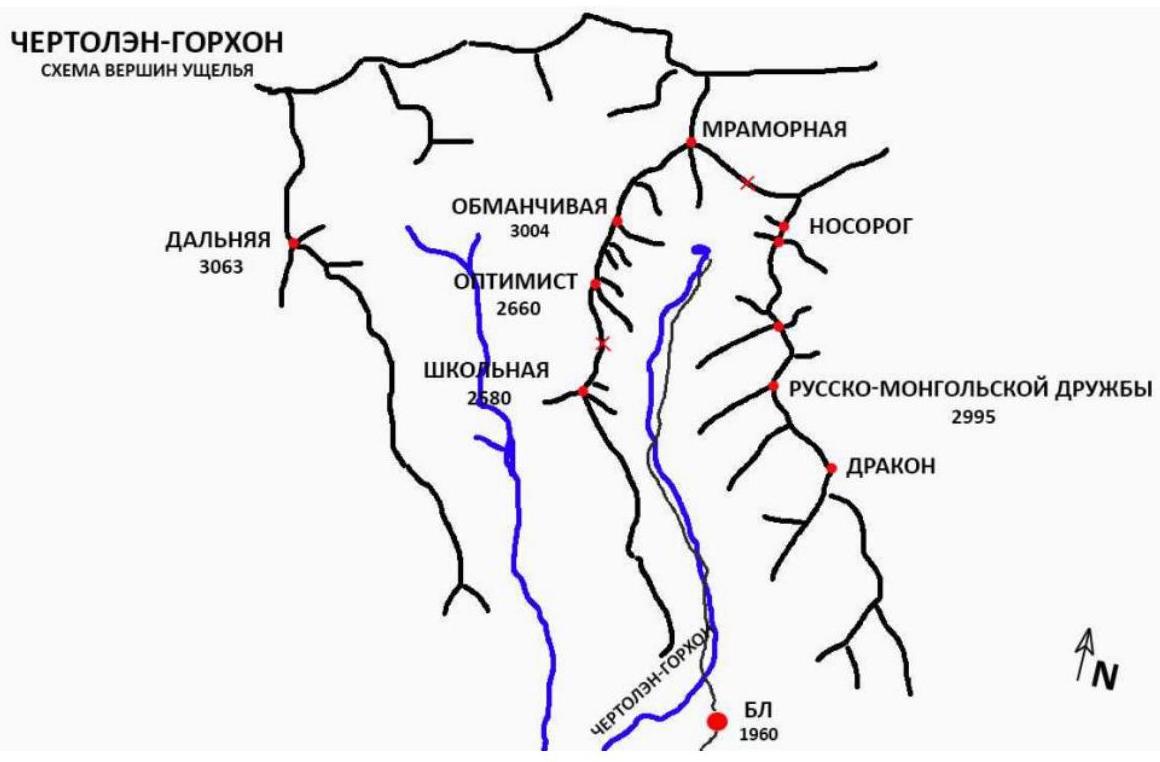
Photo 5.
6. Characteristics of the Area
The Nosorog peak is located in the upper reaches of the Chertyolen-Gorkhon valley in the Tunkin range of the Eastern Sayan Mountains, to the west of the Khubuty River valley. The valley is rarely visited. From Irkutsk: 270 km, approximately 5 hours by car. The nearest populated area: Nilova Pustyn settlement, Khoito-Gol village in the Tunkinsky district of the Republic of Buryatia (district center — Kyren settlement). Path to the peak: move along the old road to the "Sukhoy Ruchey" tourist base — 5 km, then transport by a high-clearance vehicle up the road — 10 km, or on foot to the Chertyolen-Gorkhon River; from the river in the valley, a trail leads to BL — 6 km. Valley features: "dead-end"; regularly visited by local herbalists and wild food gatherers; possible horseback transportation to BL along the trail; with snow cover, it is advisable to use sledges for transportation. At the BL site, there is a large, new winter hut installed by wild food gatherers.
7. Characteristics of the Route
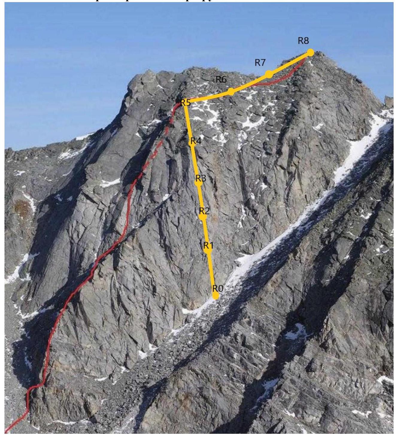
Photo 6 (October 2018).
8. Route Diagram with UIAA Symbols
| № участка | Наименование и количество крючьев (9) | Пункты страховки, характеристика в символах | Линия маршрута в символах УИАА | Сложность участка в символах | Протяжённость участка, м | Крутизна, ° | |
|---|---|---|---|---|---|---|---|
| R7–R8 | 1 | 1 | 50 | 50 | |||
| 2 | 60 | ||||||
| R6–R7 | 5 | 3 | 60 | 50 | |||
| 4 | 30 | ||||||
| R5–R6 | 7 | 3 | 70 | 55 | |||
| 4 | 60 | ||||||
| R4–R5 | 7 | 4 | 20 | 70 | |||
| 5 | 10 | ||||||
| 6 (A1) | 10 | ||||||
| R3–R4 | 10 | 10 | 6 (A1) | 50 | |||
| R2–R3 | 15 | 4 | 5 | 5 | 70 | ||
| 6 (A3) | 45 (30) | ||||||
| R1–R2 | 12 | 7 | 5 | 5 | 70 | ||
| 6 (A1) | 55 | ||||||
| R0–R1 | 10 | 10 | A1 | 5 | 20 | ||
| 6 | 40 |
9. Characteristics of Team Actions
| № участка | | | :-------: | :------------------------------------: | :--: | :------------------------------------------: | :----------------------------: | :--------------------------: | :-----------------: | :----------: | | R0–R1 | 10 | 10 | A1 | | 5 | 20 | | | | | | | | 6 | 40 | |
Comments
Sign in to leave a comment