Ascent passport to the summit Gosbezopasnost 3138 m, via Southwest ridge, cat. diff. 1B. Eastern Sayans, Tunkinskie Goltsy range, Ulagol valley, section 6.1. 2. Summit Gosbezopasnost (3138) via Southwest ridge. 3. First ascent is proposed. 4. Route nature — rocky. 5. Height difference 408 m, length 810 m, average steepness 47°. 6. Pitons driven: rock and wired 11 pcs. 7. Team's locomotion hours — 7 h. 8. No nights on the route. 9. Team:
Afanasyev A.E. MS Vasiliev M.Yu. 3rd sports rank Vinogradov N.N. 3rd sports rank Golovin V.V. 3rd sports rank Geydarov K.G. 3rd sports rank Marchukov K.F. 3rd sports rank Pospelov A.S. 3rd sports rank
- Coach Afanasyev A.E. MS
- Ascent to the summit and descent on April 29, 2010.
Description of the ascent route to the summit Gosbezopasnost (3138 m) via Southwest ridge, cat. diff. 1B.
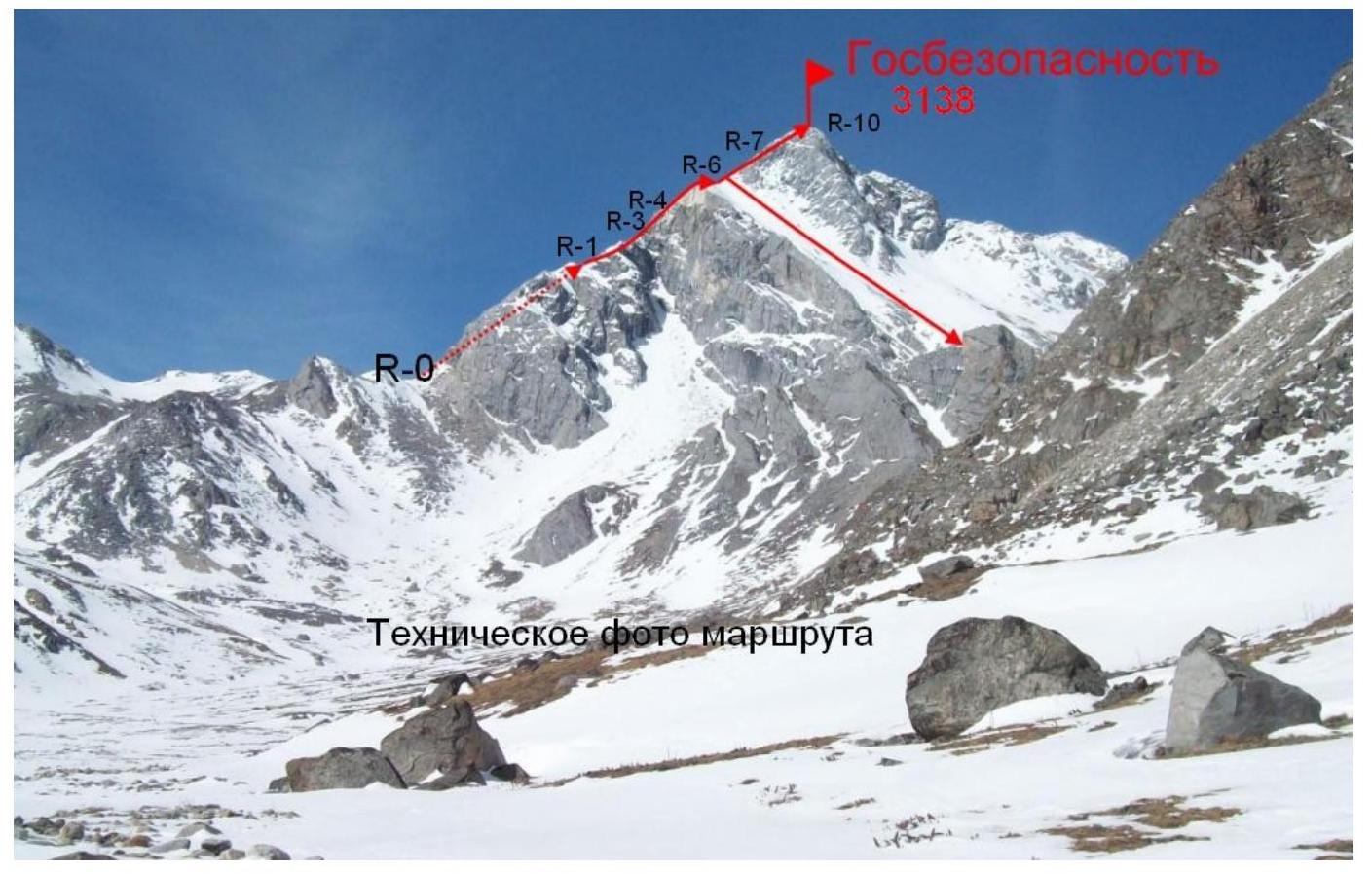
Approach along the Ulagol valley straight to the north and exit to Ulagolsky per. Start of the route is to the right of Ulagolsky per. under the rocks of the West ridge at an altitude of 2730 m.
Section R0–R1 300 m. 45° II+ Along the rocky-sandy slope to the left of the ridge to the height of 2930 m.
Section 1–2 60 m. 40° III+ Ridge of limestone slabs. To the height of 2970 m.
Section 2–3 15 m. 80° IV– External corner.
Section 3–4 80 m. 45° II– Rocky, partly snowcovered, slope. Passing to the left of the ridge.
Section 4–5 70 m. 45° II+ Even ridge.
Section 5–6 40 m. 30° I+ Ridge. Height 3030 m.
Section 6–7 120 m. 60° IV– Monolithic steep ridge. Piton belay.
Section 7–8 60 m. 55° III– Ridge. Piton belay.
Section 8–9 35 m. 55° III – To the right of the ridge. Exit to the fore-summit.
Section 9–10 30 m. 30° II– Destroyed ridge. Exit to the summit.
Descent along the ascent path to the shoulder in the ridge at a height of 3030 m. Avalanche triggered down the southern couloir. Further descent to the south along the ice crust remained after the avalanche,
on crampons with belay via ice axe.