Passport ascension to the summit Golendukhin A.L. 2441 m, via South ridge, cat. 1B diff. level 1. Eastern Sayan, Tunkinskie Goltsy ridge, Talta valley, section 6.1. 2. Summit Golendukhin A.L., 2441 m, via South ridge. 3. Proposed 1B diff. level, first ascension. 4. Nature of the route — rocky. 5. Elevation gain 200 m, length 450 m, average steepness 40°. 6. Pitons driven: rock and wired 4 pcs. 7. Team's walking hours — 4 h. 8. No overnight stays on the route. 9. Team: Aphanasiev A.E. MS
Isaenko M.Yu. nov. Mezrin E.V. nov. Mukovkin A.N. nov. Nikolaev V.A. nov. Stasyuk P.N. nov. Terentiev N.S. nov. Shershak E.M. nov.
-
Coach Aphanasiev A.E. MS
-
Ascension to the summit and return on September 21, 2007
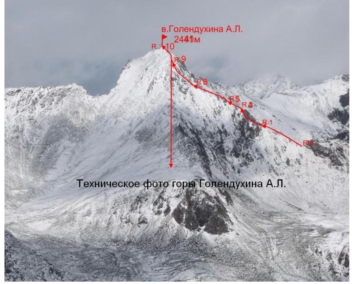
Description of the first ascension route to the summit Golendukhin A.L. 2441 m, via South ridge, cat. 2A diff. level.
The summit is located on the main Tunkin ridge at the junction of Talta and Bugotoy valleys from the south and Eke-Gol valley from the north.
Approach from Talta valley to the pass in the southern spur of MTR between Talta and Bugota valleys. Pass heigh is about 2230 m. (In tourist guides this pass is called Solnechny, and its heigh is given erroneously — 2350 m.)
Further left along the track to the South ridge of Golendukhin peak. Start of the route, gearing up, roping up.
Section 0–1 100 m. 30° I — Ridge is grassy and slightly snow-covered. Approach to the rocks.
Section 1–2 20 m. I+ Traverse right along a narrow snow shelf.
Section 2–3 10 m. 60° II+ Inner corner in the rock wall to the right of the ridge. Key section of the route.
Section 3–4, 10 m, 55°, II–. Rocky gully. Protection on outcrops.
Section 4–5, 40 m, 50°, II–. Steep slope. Exit to the ridge. Rocks to the right.
Section 5–6, 70 m, 35°, I+. To the left of the ridge. Simultaneous movement. Steep rocky-scree slope. Alternate movement. 1 wired protection.
Section 6–7, 50 m, 30°, I+. Ridge, partly sharp. Ridge leads to a steep slope.
Section 7–8, 10 m, I–. Wide gently sloping snow shelf.
Section 8–9, 80 m, 55°, II–. Steep rocky snow-covered slope in the direction with left tilt. In the upper part, transition slightly right. Exit to the "roof". Slope is scree and snow-covered.
Section 9–10, 60 m, 20° I — grassy-scree wide ridge. Exit to the summit Golendukhin A.L.
The ascension was made on the ninth day of memory of the special forces officer Golendukhin Aleksandr Lukich, who died in a clash with bandits.
Descent via south-west ridge of Golendukhin A.L. peak.