Ascent passport to the peak Zagorulko S.A. 2428 m, via South ridge, cat. 2A diff. level 1. Eastern Sayan, Tunkinskie Goltsy range, Bugotoy valley, section 6.1.
- Peak Zagorulko S.A., 2428 m, via South ridge.
- Proposed cat. 2A diff. level, first ascent.
- Nature of the route is rocky.
- Elevation gain 200 m, length 400 m, average steepness 40°.
- Pitons driven: rocky and placement type 4 pcs.
- Team's walking hours — 5 h.
- No overnight stays on the route.
- Group:
Afanasyev A.E. MS, Volodov A.N. 3rd sports rank, Pospelov A.S. 3rd sports rank, Rozin A.Yu. 3rd sports rank, Vorobyov P.Yu. badge holder, Golovin V.V. badge holder, Prokhnitsky D.A. badge holder, Tashlykov V.A. badge holder
- Coach Afanasyev A.E. MS
- Summit reach and return on August 10, 2008.
Description of the first ascent route to peak Zagorulko S.A. (2428 m) via South ridge, cat. 2A diff. level.
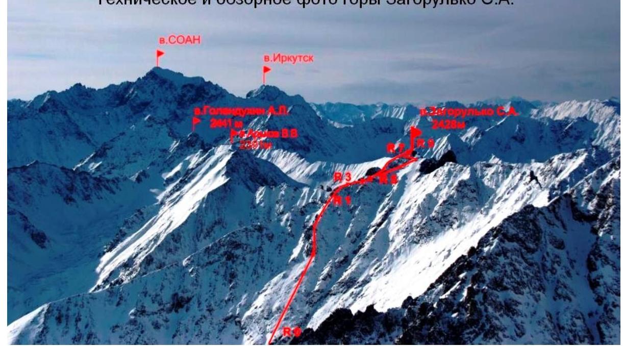
Approach from Bugotoy valley. Further rightwards along the path to cirques:
- Three-headed
- 9 May
- "Submarine" and "Submarine"
- Zagorulko.
Into the left cirque straight and leftwards. Along the left slope (Eastern part of South ridge) till steep section. Start of the route, we put on crampons, rope up.
Section 0–R1 400 m. 40° I– Steep grassy even slope. Section R1–R2 50 m. 55° II+ Snowy rock. Section R2–R3 40 m. 10° II– Sharp rocky wavy ridge. Section R3–R4 60 m. I+ Snowy shelf left of the ridge. Small descent along the slope 40°. Section R4–R5 70 m. 35° I– Snowy slope leftwards till the ridge isthmus. Section R5–R6 150 m. 30° I– Bypassing the sentinel rock rightwards along the snowy slope. Exit to Eastern ridge. Section R6–R7 50 m. 30° I– Left of the ridge. Section R7–R8 50 m. 50° II– Along SE slope till South ridge. Section R8–R9 30 m. 20° I– Along South ridge till the summit named after the special forces officer who died at the hands of criminals in North Caucasus, Zagorulko Sergey Anatolyevich.
Descent along the ascent path till base camp. Technical and panoramic photo of Zagorulko S.A.