
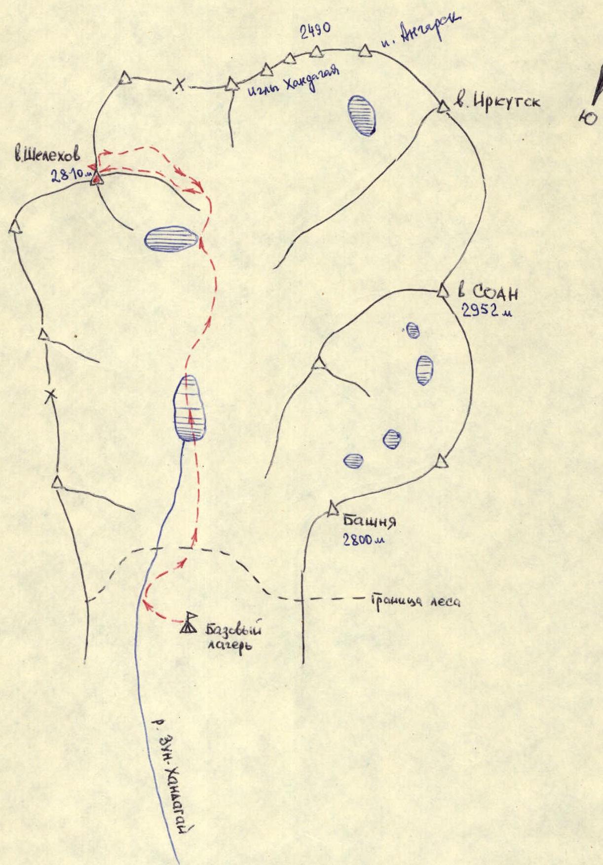
Geographical location, sporting characteristics of the area
The Zun-Khandagai valley is located in the middle part of the main watershed ridge of the Tunkinskie Goltsy mountains in the Eastern Sayan.
The alpine-type relief of the area with sharp peaks and heavily serrated ridges provides opportunities for classifying a number of sports routes in this valley.
Routes are classified only on SOAN-3B, 4A, 4B.
The absolute heights of the valley are close to 3000 m. The peak Shelekhov (2810) is located in the northwest corner of the upper valley, forming with its southern and southeastern ridges a small, cirque-like feature, which opens into a wide couloir leading to the northwest lake of the valley.
The passage of routes is often complicated by significant snow cover, which falls early in autumn and melts mostly by the end of May or June.
The approach with a load to the base camp at the forest boundary from the Tunkinskaya valley, along the road leading from the village of Tagarkhay, takes one and a half walking days.
Route description
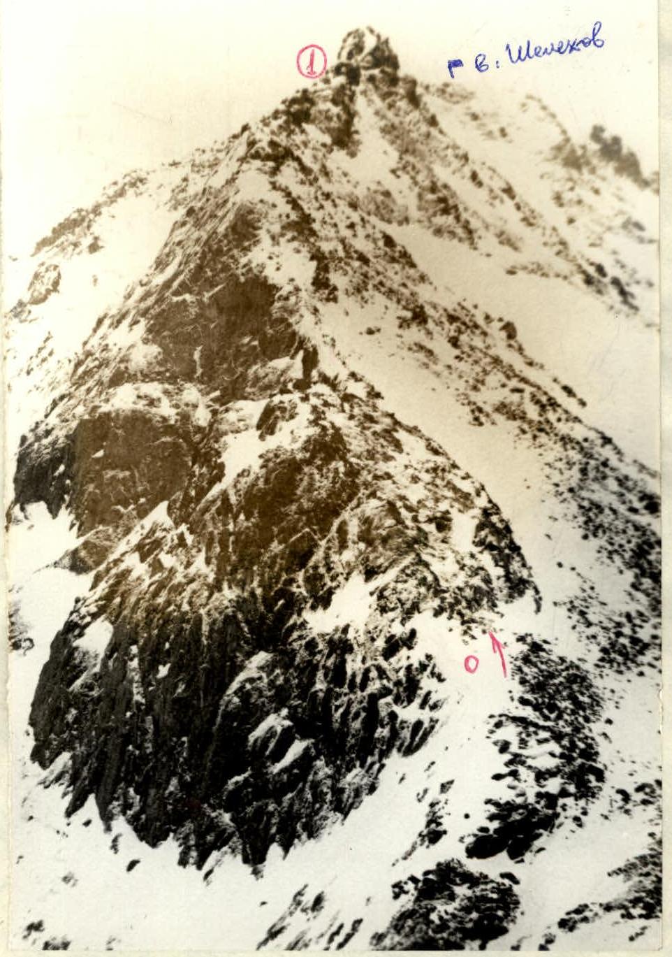
From the base camp at the forest boundary - to the right (orographic) upper cirque. From the lake to the northwest, the entire route to the very summit is clearly visible (photo 1).
Passing along the eastern shore of the lake, ascend to a gentle ridge that leads directly to the route. At the end of the gentle part of the ridge - rope up.
R0–R1, 250–300 m. The route follows a wide, destroyed (photo 2–4) rocky ridge, turning into a narrow ridge (200 m) with numerous sections of easy climbing, where insurance is alternate through the ridge outcrops. With snow cover - overcoming snowdrifts.
R1–R2. The most difficult section - 3–4 ropes - a narrow, destroyed ridge (photo 5, 6) with overcoming small rocky slabs and failures (1–2 m) and small snow cornices. The exit to the sub-summit and descent from it - into a failure - insurance is alternate, through outcrops.
R2–R3. From the failure, a 250–300 m ascent to the summit follows easy, destroyed rocks (photo 7), initially with two small walls (6 m) of easy climbing. Insurance at the beginning of the ascent is alternate through the ridge outcrops. A gentle exit to the summit along a scree ridge.
Descent along the narrow northern ridge for 200 m with alternate insurance through outcrops and then to the east along the scree side (wide) couloir to a narrow valley, exiting to the lake.
Route assessment
This route requires participants to have elementary rock climbing technique and skill in organizing insurance through ridge outcrops.
The time of movement along the route: in winter, depending on weather conditions, snow cover and group composition - 1.5–4 hours.
The time spent on the ascent from the base camp at the forest boundary, taking into account all the above conditions, will be 8–12 hours, from the camp on the lake - 3.5–6 hours.
The group needs to have 2–3 rock anchors. According to the general opinion of the group - the route passed in these conditions corresponds to 1B cat. diff.
Group composition:
- Plotnikov N.K. - 2nd sports category, leader
- Petrushin Yu.A. - 1st sports category, participant
- Stanevich A.M. - 2nd sports category, participant
- Titova L.A. - 2nd sports category, participant
Table of main characteristics of the passed route by sections
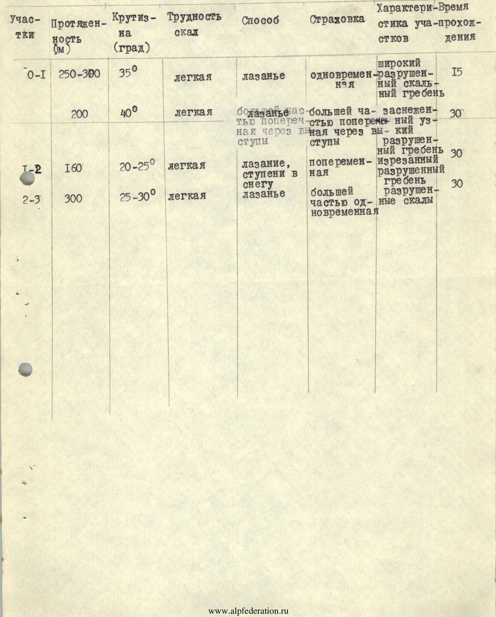
| Sections | Length (m) | Steepness (deg) | Rock difficulty | Method | Insurance | Characteristics of sections | Time taken (min) |
|---|---|---|---|---|---|---|---|
| R0–R1 | 250–300 | 35° | easy | climbing | simultaneous | wide destroyed rocky ridge | 15 |
| 200 | 40° | easy | climbing | mostly alternate through outcrops | snow-covered narrow destroyed ridge | 30 | |
| R1–R2 | 160 | 20–25° | easy | climbing, steps in snow | alternate | rugged destroyed ridge | 30 |
| R2–R3 | 300 | 25–30° | easy | climbing | mostly simultaneous | destroyed rocks | 30 |
Scheme

Comments
Sign in to leave a comment