Ascent Report
Peak Charskie Zori (2920 m) — Eastern wall of the Southern counterfort — Route 5A cat. diff. (proposed), first ascent — Eastern Sayan, Tunkinskie Goltsy ridge, Barun-Khandagai gully, 6.1
Leader: Klepikov A.A. Participants:
- Ilyinsky V.A.
- Shcherban A.N.
2013
Ascent Passport
-
Eastern Sayan, Tunkinskie Goltsy ridge, Barun-Khandagai gully, 6.1
-
Peak Charskie Zori (2920 m), via E wall of S counterfort.
-
Proposed — 5A — first ascent.
-
Route type: rock.
-
Route height difference: 474 m
Route length: 676 m. Main section height difference: 290 m. Main section length: 356 m. Section lengths:
- VI cat. diff. — 70 m
- V cat. diff. — 123 m
- IV cat. diff. — 141 m. Average steepness of the main section: 64.5 degrees
- Hooks left on the route:
total: 0; incl. bolted: 0. Used on the route:
- bolted hooks — 0
- rock hooks (incl. anchors) — 30
- chocks — 3
- friends — 40
- sky-hooks (incl. fee-fees) — 11
Total anchor points for artificial climbing (ITO): 25
- Team's climbing hours (to the summit): 13:00; days — 2
Number of bivouacs on the route — 0
- Leader: Klepikov Alexander Alexandrovich (Master of Sports)
Participants:
- Ilyinsky Vasily Andreevich (1st sports category)
- Shcherban Alexey Nikolaevich (2nd sports category)
-
Team coach: Afanasyev Andrey Evgenievich (Master of Sports), 1st cat. diff.
-
Route reconnaissance: July 31, 2012 (1 hour)
Route entry: 06:00, August 1, 2012.
Summit reach: 18:00, August 1, 2012.
Return to Base Camp: 22:00, August 1, 2012.
- Report responsible: Klepikov A.A. (Baikalteam@Gmail.com)
Photo of the general view of the Northern wall of the peak
Kupol.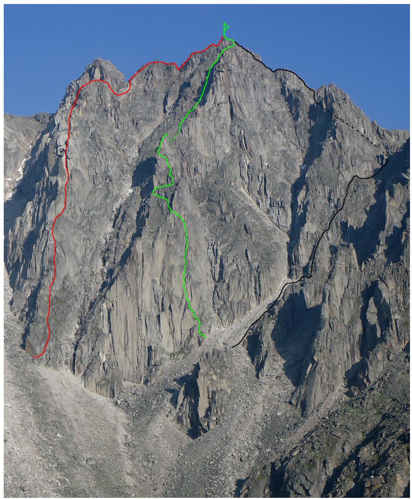
Paciczi — Wrong Route
Red — Glazunov's 2012 route, 4B cat. diff.
Black — Descent route, 2B–3A cat. diff.
Photo of the route profile from the right (Main section of the route). Photo taken on July 30, 2012 during the first ascent of 4B cat. diff. on peak Sever, via N wall of S3 pl.
Photo height 2350
m.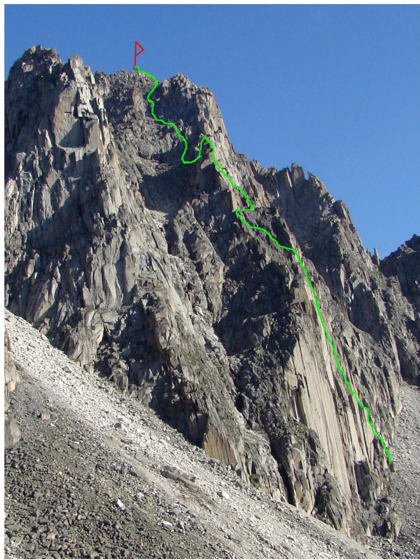 Drawn
route
profile
Drawn
route
profile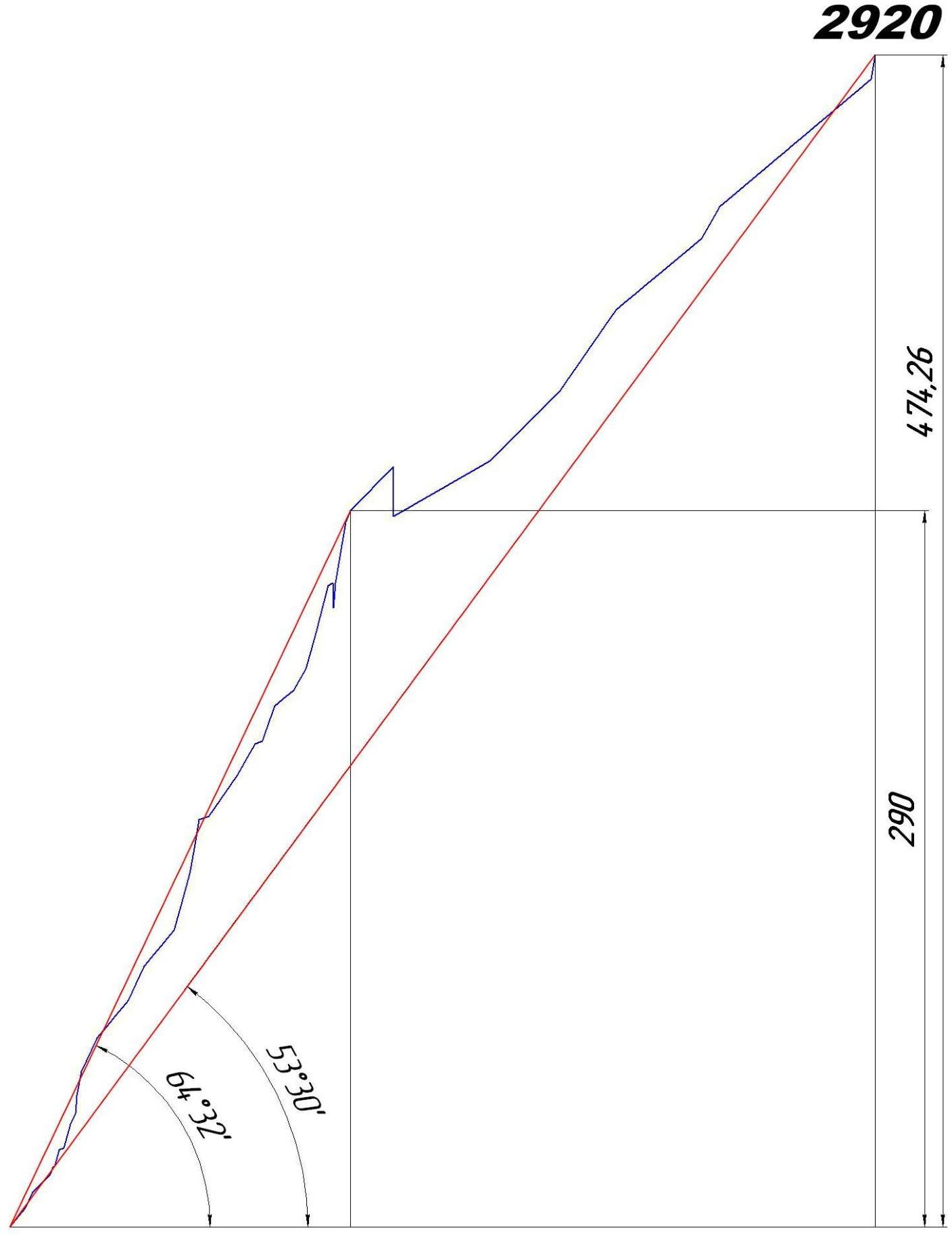
2445 m. Panorama of the Alaska circus peaks

Map-Scheme of Barun-Khandagai Gully
Barun-Khandagai gully is one of the most promising areas in Eastern Sayan for sport and competitive mountaineering.
Peak Kupol (2954 m) is the dominant peak in the area. Located in the Tunkin district of Buryatia Republic. The nearest major settlement is Arshan village.
From Arshan, a high-clearance vehicle can reach
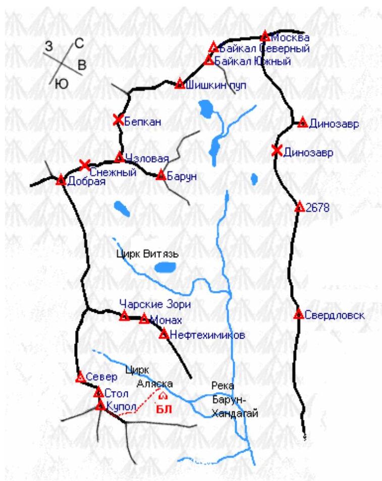
the entrance to the gully, known as Barunovskaya "meadow" — a journey of about 15 kilometers. Further entry into the gully follows a trail, and the area is popular with tourists during the summer. The Alaska circus is located to the left along the gully.
- Elevation gain on the approach: 1400 m
- Length: approximately 15 km
- Approach time in summer: 6–8 hours
- Approach time in winter: 5–6 days (due to heavy snowfall)
- Frequency of visits by mountaineering and climbing groups: 2–3 groups per year
Peak Charskie Zori, like most peaks in Barun-Khandagai gully, is not very popular due to the greater interest of climbers in the northern wall of peak Kupol. However, the counterforts and walls on the southern and eastern sides of the peak are quite interesting objects for ascents. Significant elevation gain combined with high steepness and the solidity of the rocks that make up the peak offer great prospects for exploration and use of routes for training purposes.
A month before us, in June 2012, Evgeny and Ekaterina Glazunov completed a first ascent of 4B cat. diff. via the counterfort to the left of our route. Our route, however, made history by being the first to traverse the previously untouched eastern wall of the southern counterfort.
Ascent Schedule
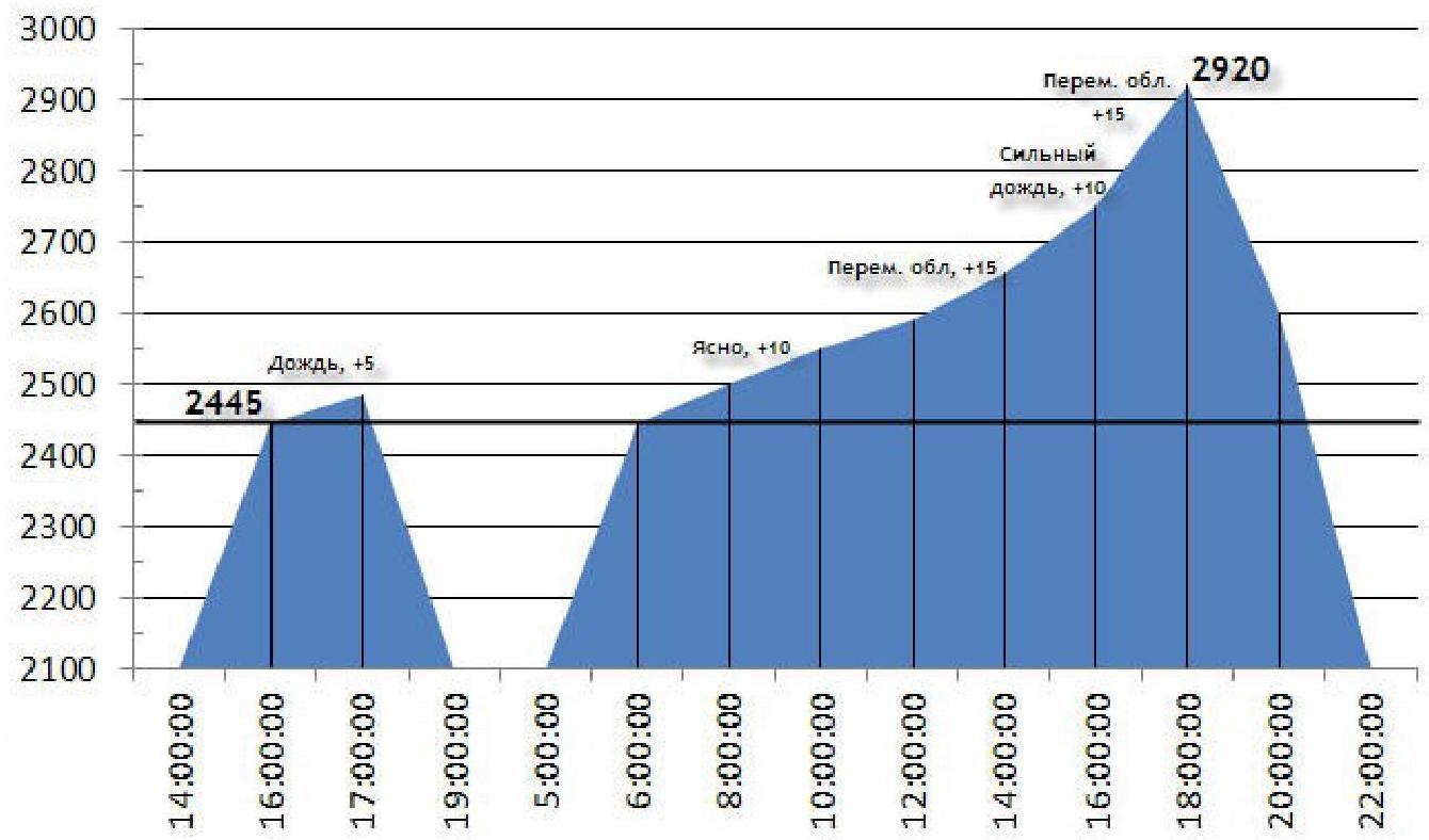
Team's movement schedule on the route:
- July 31, 2012: from 16:00 to 17:00 — processed one rope length of the route, had to descend due to the onset of rain. Sections: R0–R8.
- August 1, 2012: from 06:00 to 15:30 — sections R0–R32 were completed, the main part of the route was traversed. Rain started, lasting about an hour.
- August 1, 2012 — from 15:00 to 18:00 — sections R32–R42 were completed, the entire team reached the summit at 2920 m.
- August 1, 2012 — from 18:30 to 22:00 — descent to Base Camp via a 2B–3A route (NE ridge) N/k.
| Section | Chocks | Friends | Rock Hooks | Sky Hooks | Bolts | Route diagram in UIAA M 1:2000 symbols, Sheet 1 | Length (m) | Steepness (degrees) | Climbing Grade | ITO |
|---|---|---|---|---|---|---|---|---|---|---|
| R35–R36 | - | 1 | 2 | - | - | 45 | 3+ | |||
| R34–R35 | - | 1 | 1 | - | - | 45 | 30 | 2- | ||
| R33–R34 | - | - | - | - | - | 20 | 90 | |||
| R31–R32 | - | 1 | 1 | - | - | 5 | 70 | 5- | ||
| R30–R31 | - | 3 | - | 25 | 80 | 5+ | ||||
| R29–R30 | 1 | 4 | 2 | - | - | 20 | 75 | 6- | ||
| R28–R29 R27–R28 | - | 3 | 2 | - | - | 15 | 75 | 5+ | ||
| R26–R27 | - | - | 1 | - | - | 10 | 40 | 2+ | ||
| R25–R26 | 15 | 70 | 5- | |||||||
| R24–R25 R23–R24 | - | 1 | 1 | - | -- | 15 | 20 | 2- | ||
| R22–R23 | 15 | 60 | 4+ | |||||||
| R21–R22 | - | 1 | 1 | - | - | 20 | 55 | 4+ | ||
| R19–R20 | - | 3 | 1 | 2 | 17 | 75 | 6- | A1 | ||
| R18–R19 | 1 | 5 | - | - | 16 | 80 | 6- | A1 | ||
| R17–R18 | - | 1 | 4 | 3 | - | 8 | 75 | 5+ | A1 | |
| :--: | :--: | :--: | :--: | :--: | :--: | :--: | :--: | :--: | :--: | :--: |
| R15–R17 | - | 1 | - | - | 14 | 75 | 5- | |||
| R14–R15 | - | - | 1 | 10 | 50 | 4- | ||||
| R13–R14 | - | 2 | - | - | - | 15 | 65 | 5- | ||
| R12–R13 | - | 1 | - | 20 | 50 | 3- | ||||
| R11–R12 | - | 1 | 1 | - | - | 15 | 65 | 5+ | ||
| R10–R11 | 10 | 80 | 6- | A2 | ||||||
| R9–R10 | 1 | 1 | 4 | 6 | - | 7 | 85 | 6- | A0 | |
| R8–9 | 5 | 65 | 4- | |||||||
| R7–8 | - | 2 | 2 | - | - | 10 | 75 | 4+ | ||
| R5–6 | - | 1 | 1 | - | - | Photo 1 | 7 | 75 | 5- | |
| R3–4 | - | 3 | - | - | - | 3 | 40 | 4- | ||
| R2–3 | - | 10 | 45 | 3- | ||||||
| R1–2 | Photo 1 | 7 | 65 | 4+ | ||||||
| R0–R1 | - | - | - | - | - | Photo 1 | 10 | 50 | 2- | |
| Section | Chocks | Friends | Rock Hooks | Sky Hooks | Bolts | Route diagram in UIAA M 1:2000 symbols, Sheet 2 | Length (m) | Steepness (degrees) | Climbing Grade | ITO |
| R41–R42 | - | 3 | - | - | - | 10 | 80 | 5- | ||
| R40–R41 | - | - | - | - | - | 80 | 40 | |||
| 80 | 40 | |||||||||
| 21 | ||||||||||
| R39–R40 | - | - | 2 | - | - | 15 | 60 | 4- | ||
| R37–R39 | - | - | - | - | - | 45 | 40 | 2+ | ||
| 40 | 55 | |||||||||
| R36–R37 | - | 1 | 3 | - | - | 4+ |
Relief Description
R0–R1 10 m, 50°, 2 — Approach to the belay station. R1–R2 7 m, 65°, 4+ Up to the shelf. R2–R3 10 m, 45°, 3 — Shelf. R3–R4 3 m, 40°, 4 — Approach to the next shelf. R4–R5 1 m, 30°, 2 — Shelf. R5–R6 7 m, 75°, 5 — Crack in the internal corner. R6–R7 2 m, 20°, 2 — Shelf. R7–R8 10 m, 75°, 4+ Wall. Comfortable station. R8–R9 5 m, 65°, 4 — To the system of vertical cracks. R9–R10 7 m, 85°, 6 — , A0 Vertical cracks. R10–R11 10 m, 80°, 6 — , A2 Narrow, dirty crack upwards, slightly left. R11–R12 15 m, 65°, 5+ Upwards — right. R12–R13 20 m, 50°, 3 — Through a system of ledges. Comfortable station. R13–R14 15 m, 65°, 5 — Through a system of flakes. R14–R15 10 m, 50°, 4 — Bypass on the right. R15–R16 8 m, 75°, 5 — Chimney. R16–R17 6 m, 75°, 4+ Chimney. R17–R18 8 m, 75°, 5+, A1 Exit to a shelf under an overhang. Comfortable station. R18–R19 16 m, 80°, 6 — , A1 From the station, slightly down to reach the crack on the left. Through the crack. R19–R20 17 m, 75°, 6 — , A1 Move left and up through cracks and smoothed relief. R20–R21 4 m, 20°, 1+ Shelf. R21–R22 20 m, 55°, 4+ Upwards — right, to a shelf. Comfortable station. R22–R23 15 m, 40°, 3+ Traverse left. R23–R24 15 m, 60°, 4+ Up to a shelf. R24–R25 15 m, 20°, 2 — Traverse along the shelf to the right. R25–R26 15 m, 70°, 5 — Wall. R26–R27 10 m, 40°, 2+ Shelf. R27–R28 10 m, 60°, 4 — Wall, start of the first bastion. R28–R29 15 m, 75°, 5+ Cracks under the ledge. R29–R30 20 m, 75°, 6 — Ledge is bypassed on the left, further through cracks, exit to the top of the first bastion, to the gap. Very uncomfortable station, possibly only two people can fit. R30–R31 25 m, 80°, 5+ Need to step over a meter-wide gap between the first and second bastion, to a vertical wall, difficult climbing.
R31–R32 5 m, 70°, 5 — R32–R33 25 m, 45°, 3+ Exit to the second bastion. Comfortable station. R33–R34 20 m, 90° R34–R35 45 m, 30°, 2 — R35–R36 40 m, 45°, 3+ Through scree, sticking to the right part, exit under the summit rock. R36–R37 40 m, 55°, 4+ R37–R38 30 m, 40°, 2+ R38–R39 15 m, 40°, 2+ R39–R40 15 m, 60°, 4 — R40–R41 80 m, 40°, 2 — Through scree, sticking to the right part, exit under the summit rock. R41–R42 10 m, 80°, 5 — To the summit rock.
Technical Photo of the Route
Photo taken on August 1, 2013. Photo height 2120
m.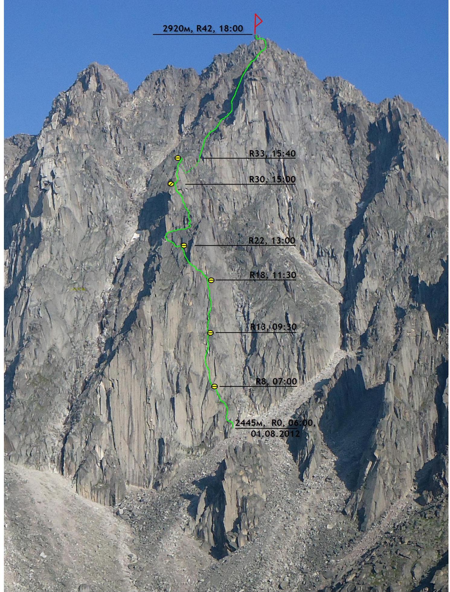
Characteristics of the route and team's actions on the wall. The route, laid by our team, passes through the eastern wall of the southern counterfort of peak Charskie Zori.
The route was climbed using free climbing, with the application of ITO on key sections. The maximum difficulty of sections climbed using free climbing is 6B (French grade), ITO — A2.
The route length is 676 m. On the route:
- 6 intermediate stations,
- 1 rappel station.
The rest of the route was climbed with alternate and simultaneous belays.
The most challenging part of the route is located in the lower half. The upper part of the route may be avalanche-prone in winter, but there are rock outcrops for station organization and hook belays.
The route's difficulty is comparable to 5th category routes.
- 5B Erydag, left part, 3rd stage (Nekrasov, 1986);
- 5A Dinosaur, left part, NW wall (Morozov, 2001);
- 5A Argada, grey "slabs", right part, E wall (Shershnev, 2004);
however, it is longer than the last two.
Our route is more challenging than classified routes such as:
- Route 5A, Brone nosets, central part, 3rd stage (Afanasyev, 2006);
- Route 5A, Brick — May 9, E wall (Afanasyev, 2009).
The route starts slightly to the left of the scree chute (be cautious of rockfall during bad weather, and potential avalanches in winter). To the left, the route is bounded by complex vertical walls, and to the right by the scree chute.
The route is relatively monolithic, with intrusive-type rocks, mainly granite and syenite, and is relatively rockfall-safe except for the upper, weathered part and the descent. Most stations were organized in rock-protected areas.
The route has three key sections:
- R8–R12
- R17–R20
- R28–R31
The route was used for training purposes. To the point R18, the first climber was Ilyinsky V.A., then due to worsening weather, Klepikov A.A. worked as the lead climber to the summit, and Shcherban A.N. followed as the third climber for the entire route.
The first climber worked on two ropes, one of which is a dynamic rope meeting UIAA requirements, and all participants moved on the rope with a safety catch. To speed up the work, mainly:
- friends
- anchor hooks
were used. The second climber, traveling light, quickly followed the rope, collecting only friends and making backups. The third climber collected hooks and other gear. During simultaneous movement, the number of intermediate points was not less than four per belay for a team of three.
Photo 1. Start of the Route.
Start of the route, belayer at station R1, leader on section R5–R6. The route is visible up to point R20. Lead climber is Ilyinsky
V.A.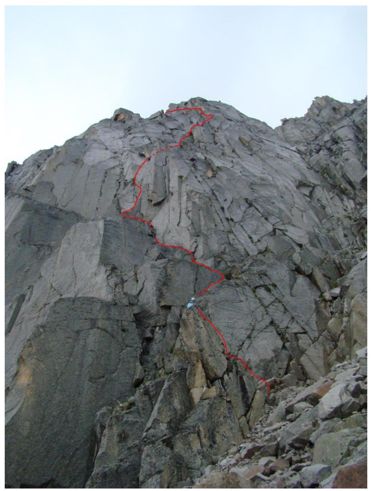
Photo 2. First key section. Second rope. The first key section of the route, taken from point R8, leader on section R10–R11. Difficult climbing and ITO. Reliable belay, monolithic relief, rich choice of belay points:
- anchors go well,
- small and medium friends. Lead climber is Ilyinsky V.
A.
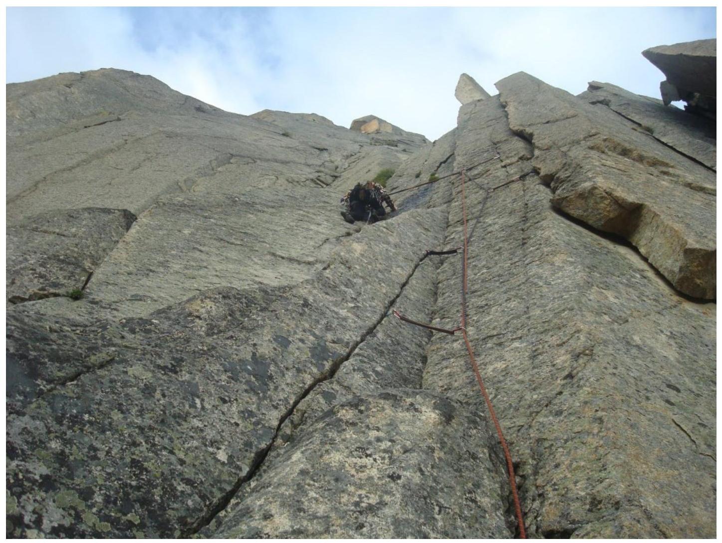
Photo 3. Third rope.
Photo taken from point R13, leader on section R13–R14. Easy climbing, choice of points is not limited. Lead climber is Ilyinsky V.
A.
Photo 4. Second key section. Fourth rope. Photo taken from point R18, leader on section R18–R19. Difficult climbing and ITO. Reliable belay, medium and large friends go well up to a cam №3, at the end of the section — small friends and anchors. Lead climber is Klepikov A.
A.
Photo 5. Second key section. Fourth rope, view from above.
Photo taken from point R20, section R19–R20 is visible. Very difficult climbing, limited choice of belay points, monolithic smoothed relief. Large anchors and small friends go well. Creative
climbing.
Photo 6. Middle part of the Route.
Photo taken from point R21, the route is visible up to point R30. Sections of easy climbing and the third key section at the
end.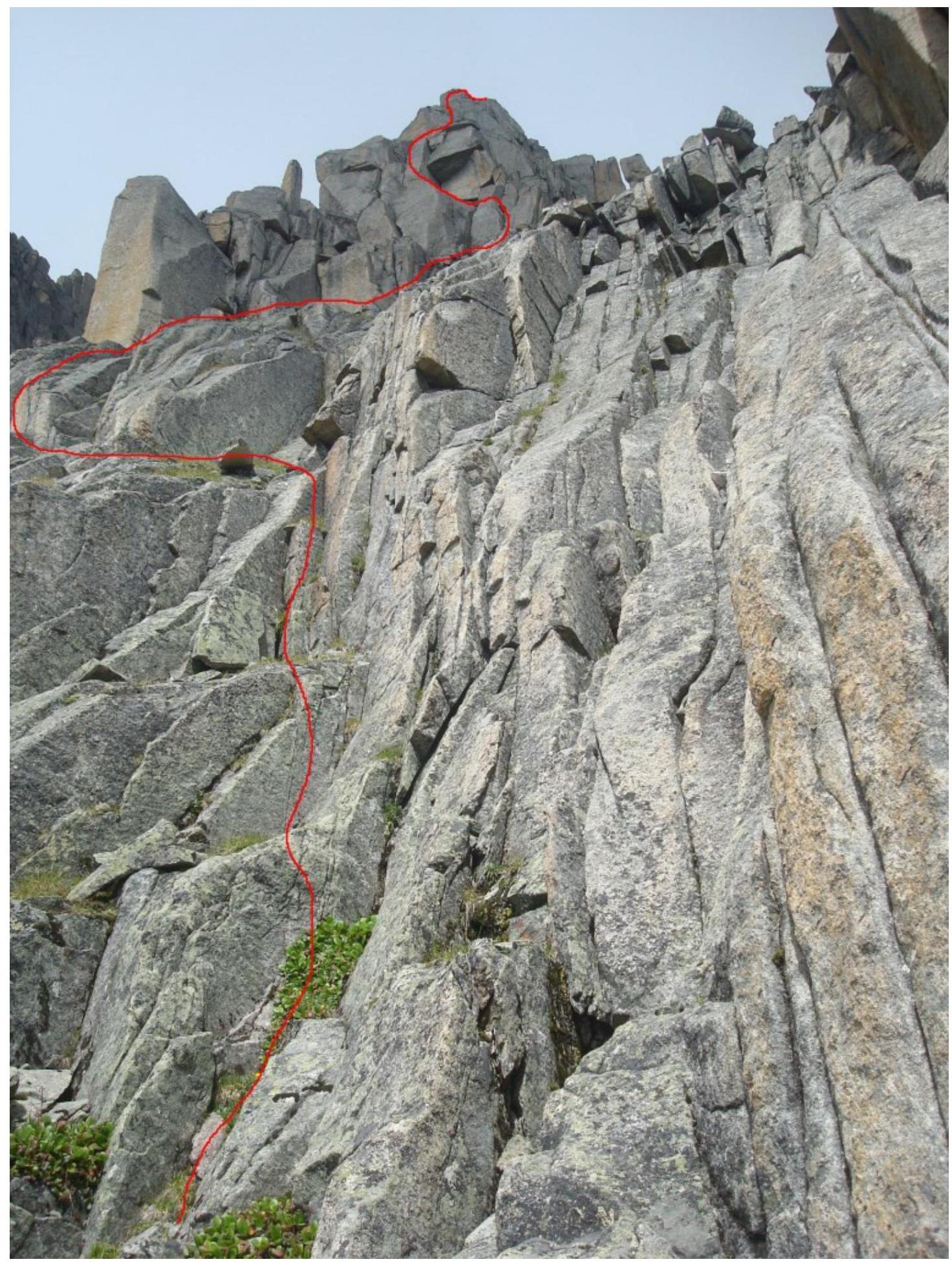
Photo 7. Third key section. Seventh rope. Photo taken from point R27, leader on section R28–R29. Difficult climbing, good for:
- small and medium friends,
- anchors.
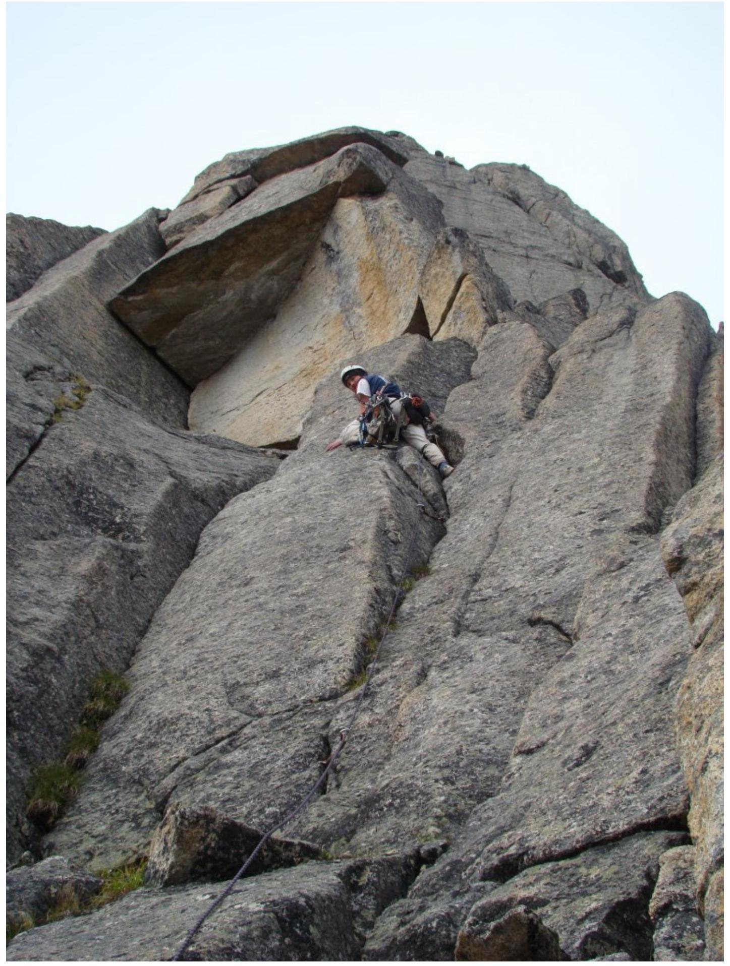
Photo 8. Third key section. Seventh rope. View downwards.
Photo taken from section R29–R30, participants on sections R27–R28 and
R28–R29.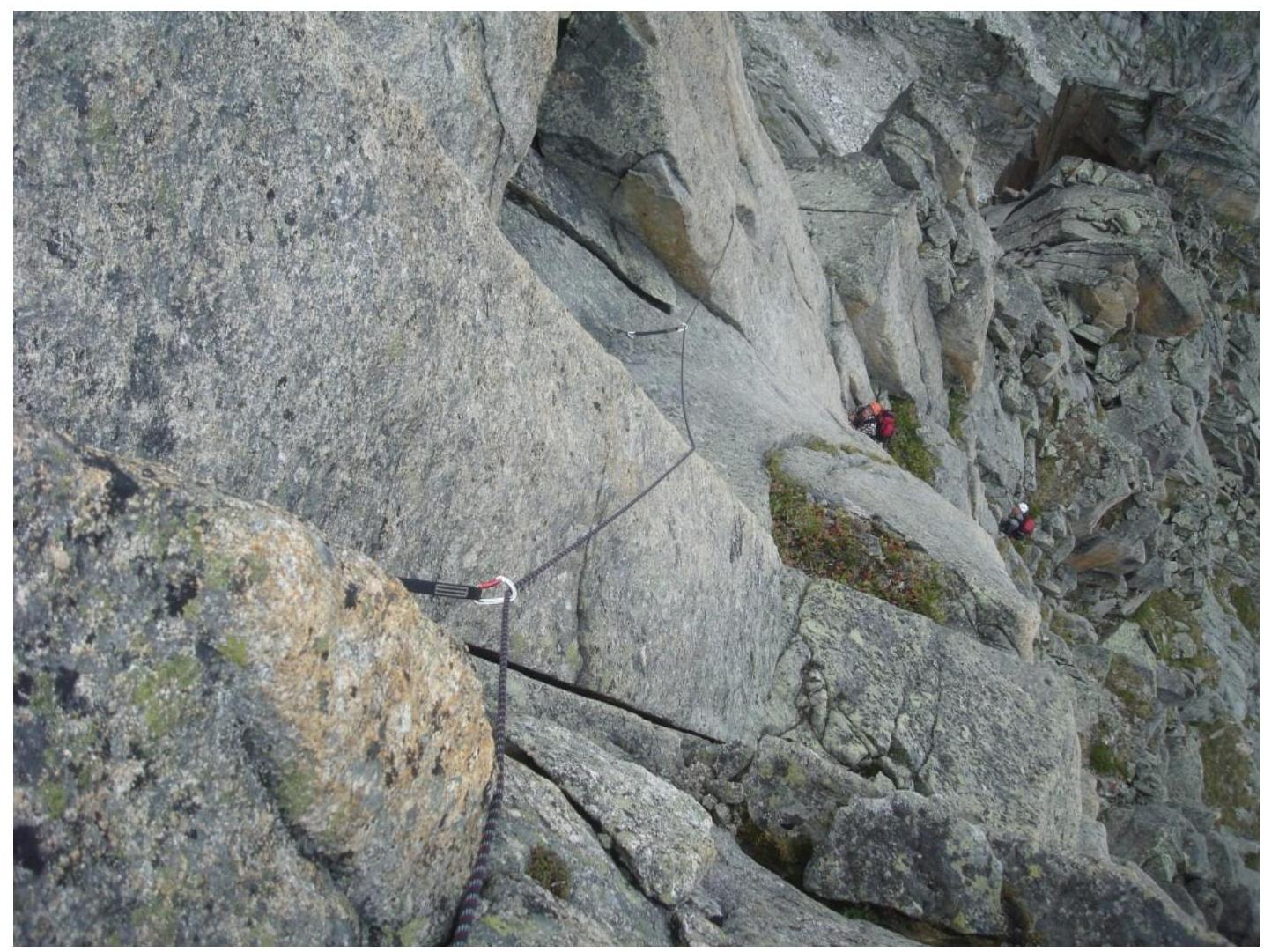
Photo 9. Third key section. Eighth rope.
Photo taken from point R30, leader on section R30–R31. Difficult climbing, section after the gap, rain started, finished the section under
rain.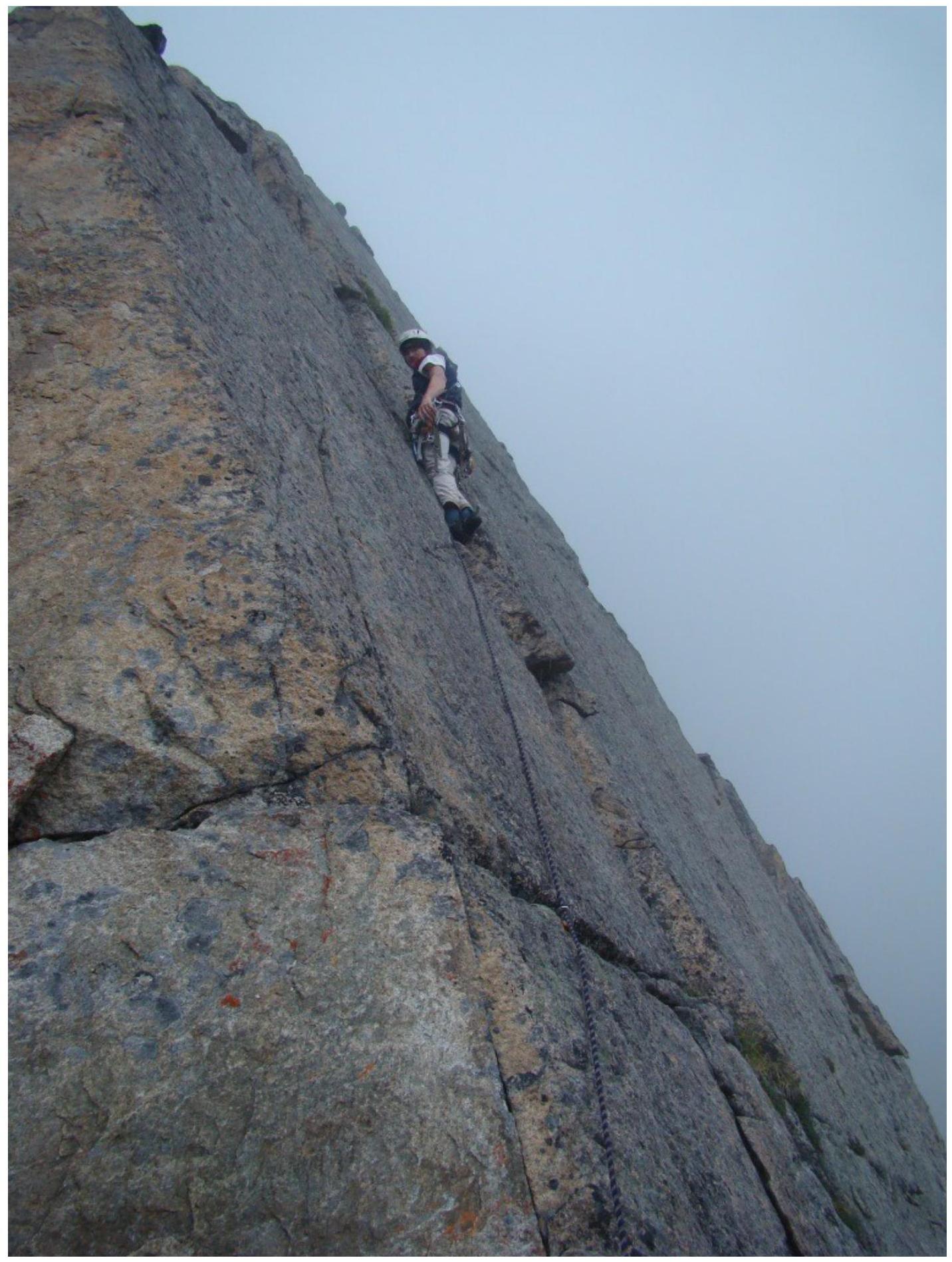
Photo 10. Third key section. Eighth rope. View downwards.
Photo taken from point R31, station at point R30 and third participant on section
R29–R30.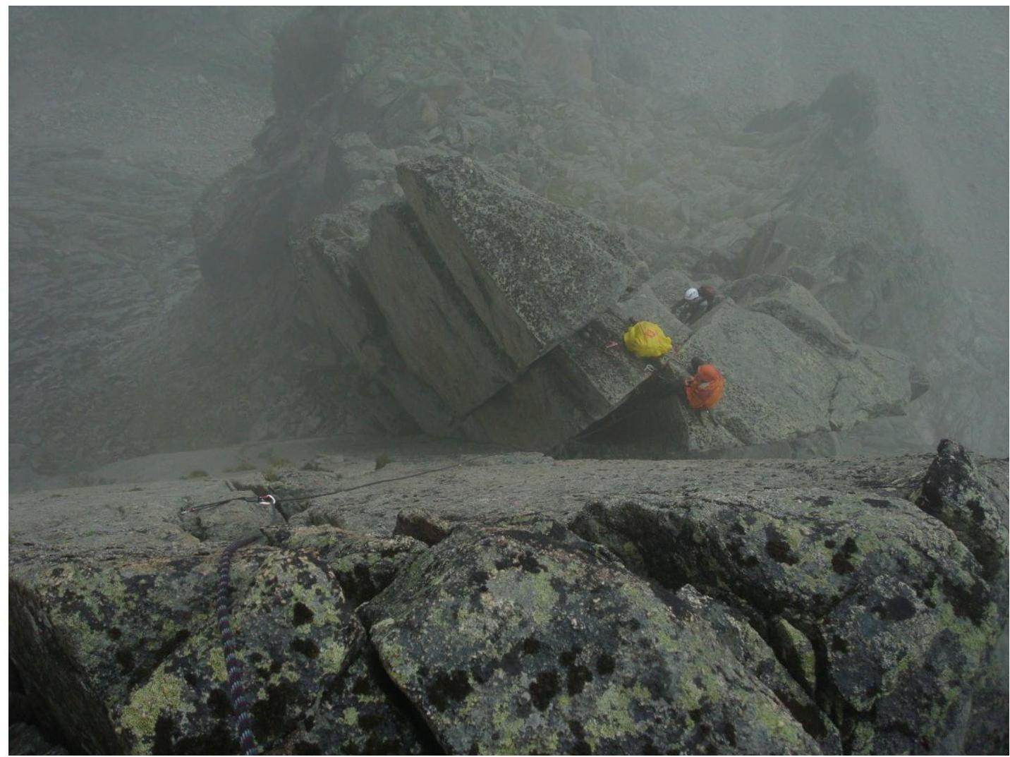
PAGE 12
PAGE 13
Photo 11. Rappel.
Photo taken from point R35, rain has
stopped.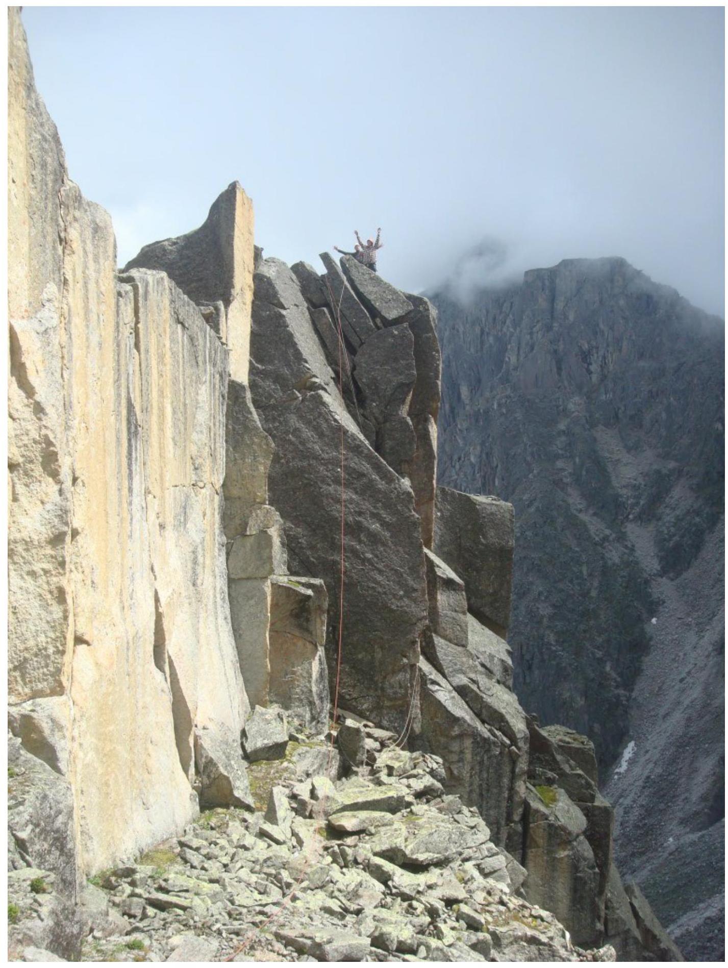
Photo 12. Rocky couloir, upper part of the Route.
Photo taken from point R35,
upwards.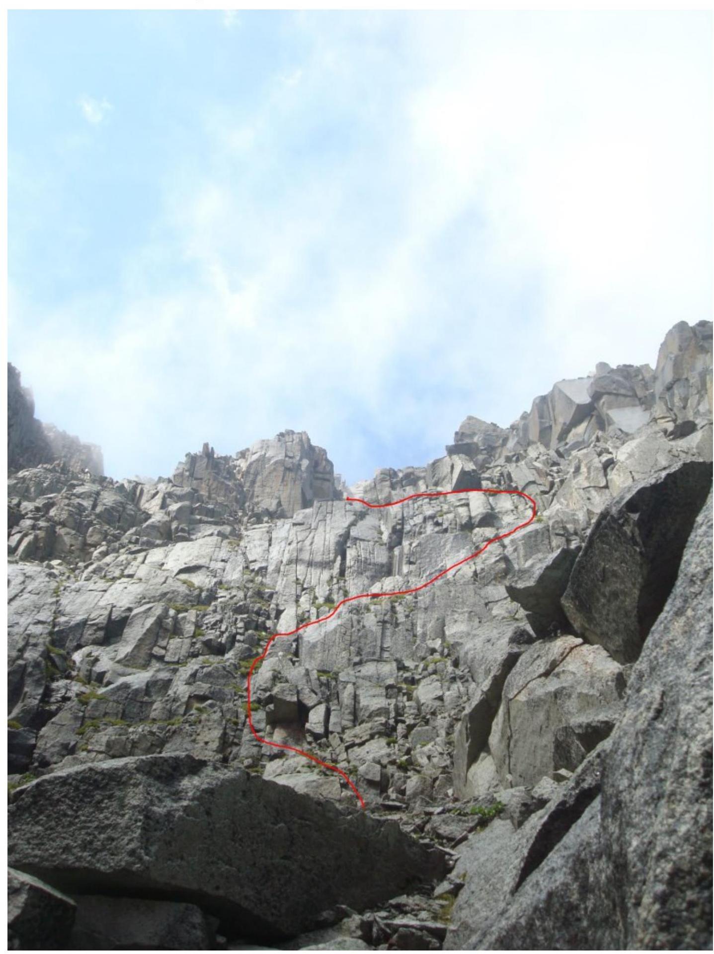
Photo 13. Summit Photo.
Shcherban A.N. Ilyinsky
V.A.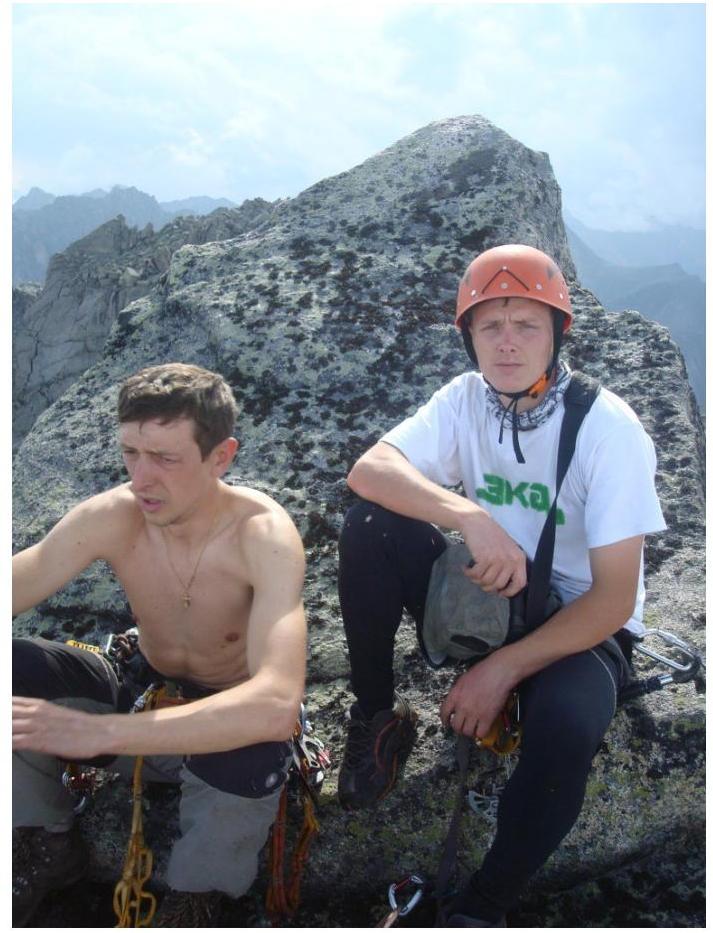
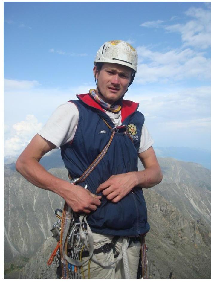
Photo 14. Summit Photo. Klepikov
A.A.