
Traverse of the Northern and Central Towers
V. Trekhglavaya with ascent along the NE ridge of the Northern Tower via route 2B category of difficulty
1. Geographical information
The V. Trekhglavaya massif is located in the Tunkinskie Goltsy ridge in the Eastern Sayan Mountains, in a long lateral spur that serves as a watershed between the Bugotoy and Kyngarga rivers.
Tunkinskie Goltsy is the highest ridge in the Eastern Sayan Mountains, stretching latitudinally for hundreds of km. The highest point is 3266 m above sea level, located in the upper reaches of the Ganga-Kharym river.
Overall, the ridge has sharp alpine forms. Within 100 km from the Arshan resort in the east to the Shumak pass in the west, there are many peaks of great interest to climbers.
The gorges are deep, covered with impenetrable taiga. The forest boundary on the southern slopes is at 1880 m, on the northern slopes at 1600–1700 m. The snow cover almost completely disappears by the end of summer. There is no glaciation.
The V. Trekhglavaya massif consists of three towers - South, Central, and North. The highest is the Central Tower, with a height of 2511 m above sea level.
The nearest settlement is the Arshan resort, 225 km from Irkutsk. From the resort to the Base camp at the confluence of the Right and Left Kyngarga rivers - 4 hours walk (uphill to the gorge).
2. Route description
From the campsite at the confluence of the Left and Right Kyngarga rivers (at benchmark 1202 m) upstream along the Right Kyngarga river to the first stream flowing in from the left. Then along the stream with a gradual ascent to the right upwards.
In the area of the forest boundary:
- dense thickets of bushes on very steep slopes.
Above the bushes:
- ascent up to the ridge along snow-covered grassy slopes;
- higher up - snowy fine scree.
Then along a gentle but sharp ridge to the foot of the rocks. Here is the first control point. The start of the route (photo 1). The approach takes 2–2.5 hours from the campsite.
From the cairn upwards through large rock fragments along the foot of the rocks of the ridge, consisting of a monolithic ridge. Then traverse through a wide snow slope (steepness 40°), which is overcome with alternate belay through an ice axe. We approach the first sentinel rock, to its middle, narrowest part. The ridge of the sentinel rock is traversed by a horizontal traverse along monolithic rocks of medium difficulty in rope teams. Belay is alternate through outcrops (photo 2).
A 5-meter wall is taken head-on, 1 rock hook, self-belay through outcrops (photo 3), vertical ropes, ascent in a sporting manner.
Then along monolithic rocks upwards to the left (photo 4). Gradually shifting left to a wide snowy couloir (photo 5, 6). We enter the couloir. Steepness of the couloir 30–35°, snow is loose 35–40 cm deep:
- steps are not formed;
- slippery;
- belay is occasionally alternate.
The couloir opens onto the ridge under the second sentinel rock, here is the 2nd control cairn (photo 7).
The second sentinel rock is bypassed on the right along a wide shelf with an exit along an inner corner onto a narrow saddle between rocks. The length of the inner corner is 7–8 m, steepness 50°. Belay is alternate through outcrops.
From the saddle, a small descent to the left under overhanging rocks along loose deep snow (photo 8). Two ropes of fixed ropes, 2 rock hooks.
Rounding the rocks and overcoming a very steep snow ascent up to 50° with a length of 1 rope, we traverse a wide snow slope with a steepness of 35° to the foot of a group of rocks (photo 9). Traverse with a gain in height (photo 1, middle of section 3). Belay is alternate through an ice axe.
Rounding the group of rocks, we enter a wide couloir, leading out onto the ridge to the foot of the sub-peak (photo 10).
Then upwards to the right, bypassing the rocks of the sub-peak. Rocks are easy, occasionally of medium difficulty. Belay is alternate. Steepness of rocks 45–50°. Caution, loose rocks! (photo 11, 12, 13).
Exit onto the sub-summit ridge along rocks of medium difficulty. A 4 m wall is taken head-on - 1 hook. Exit onto the summit of the Northern Tower along a gentle ridge. On the summit is a cairn. From the 1st cairn to the summit is 4.5 hours.
Descent onto the ridge with two sentinel rocks between the Northern and Central Towers along a snow ridge, then along easy rocks. Belay is simultaneous (photo 14).
Ascent onto the Central Tower with alternate belay. Two ropes of difficult monolithic rocks - the key section (photo 15, 16, 17, 18).
Equipment:
- 2 rock hooks;
- fixed ropes with a prusik knot.
Transition from the Northern to the Central Tower - 1 hour.
Descent onto the saddle between the South and Central Towers:
- Descent along the ridge along rocks of medium difficulty - 1 rope, belay is alternate.
- Then - descent into the couloir to the right:
- fixed ropes - two ropes;
- descent in a sporting manner;
- 1 rock hook.
Caution, loose rocks! (photo 19).
Exit onto the saddle along snowy easy rocks. Descent from the Central Tower to the saddle takes 1 hour.
From the saddle downwards along a steep snowy couloir. Steepness of the upper part of the couloir up to 60°. Descent - one rope along fixed ropes, in a sporting manner with a prusik knot. Fixed ropes are secured at the top to a large convenient rock.
Then the couloir becomes less steep, down to 45–40°. The section to point 1 (photo 1) is overcome with alternate belay through an ice axe - 7–8 ropes. After exiting the narrow throat of the couloir - then simultaneous movement.
The entire route from the Base camp and back takes 1 day.
3. Group composition
- Mikhailov A.A. - 2nd sports category - leader
- Popova L. - 3rd sports category, 3A, 3B
- Mikhailova R.T. - 2nd sports category, 4A, 4A, 4A
- Alekseev S. - 3rd sports category, 3A, 3A, 3B, 3B
- Palamarchuk S. - 3rd sports category, 3A, 3A, 3A, 3B, 3B
- Popova L. - 3rd sports category, 3A
4. Equipment
- Main rope - 3 × 40 m.
- Rock hammers - 2 pcs.
- Rock hooks - 5 pcs.
- Consumable cordelette - 5 m.
- Carabiners - 8 pcs.
- Ice axes - 6 pcs.
- Belay harnesses - 6 pcs.
- Cordelettes 4 m - 6 pcs.
Kyren - Irkutsk
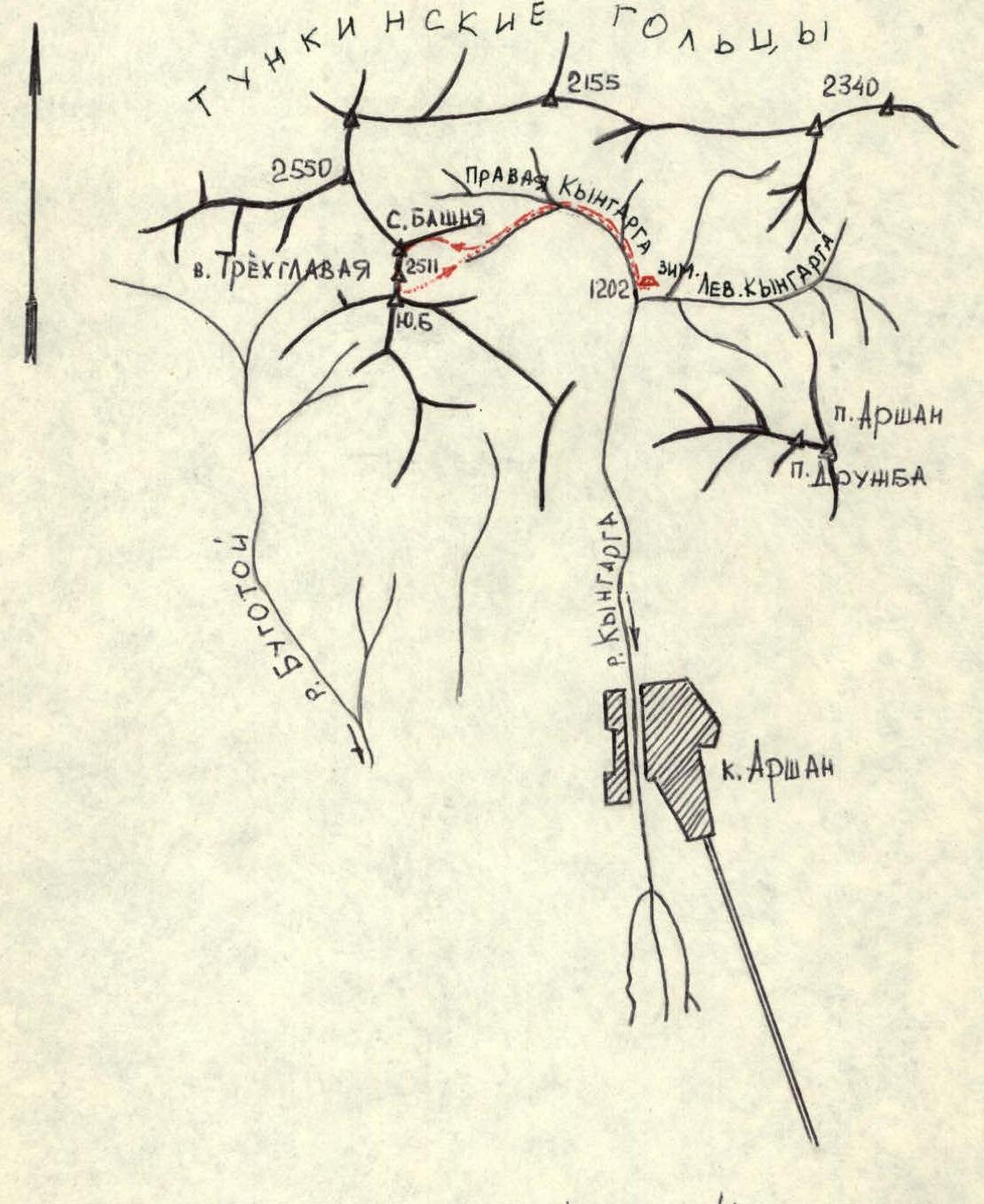
Table of main characteristics of the ascent route
Ascent route: Traverse of the Northern and Central Towers of V. Trekhglavaya with ascent along the NE ridge of the Northern Tower via route 2B category of difficulty
Height difference of the route: Base camp - 1202 m, Central Tower - 2511 m above sea level.
Steepness of the route: 40–45°
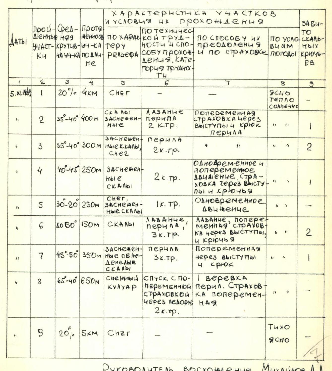
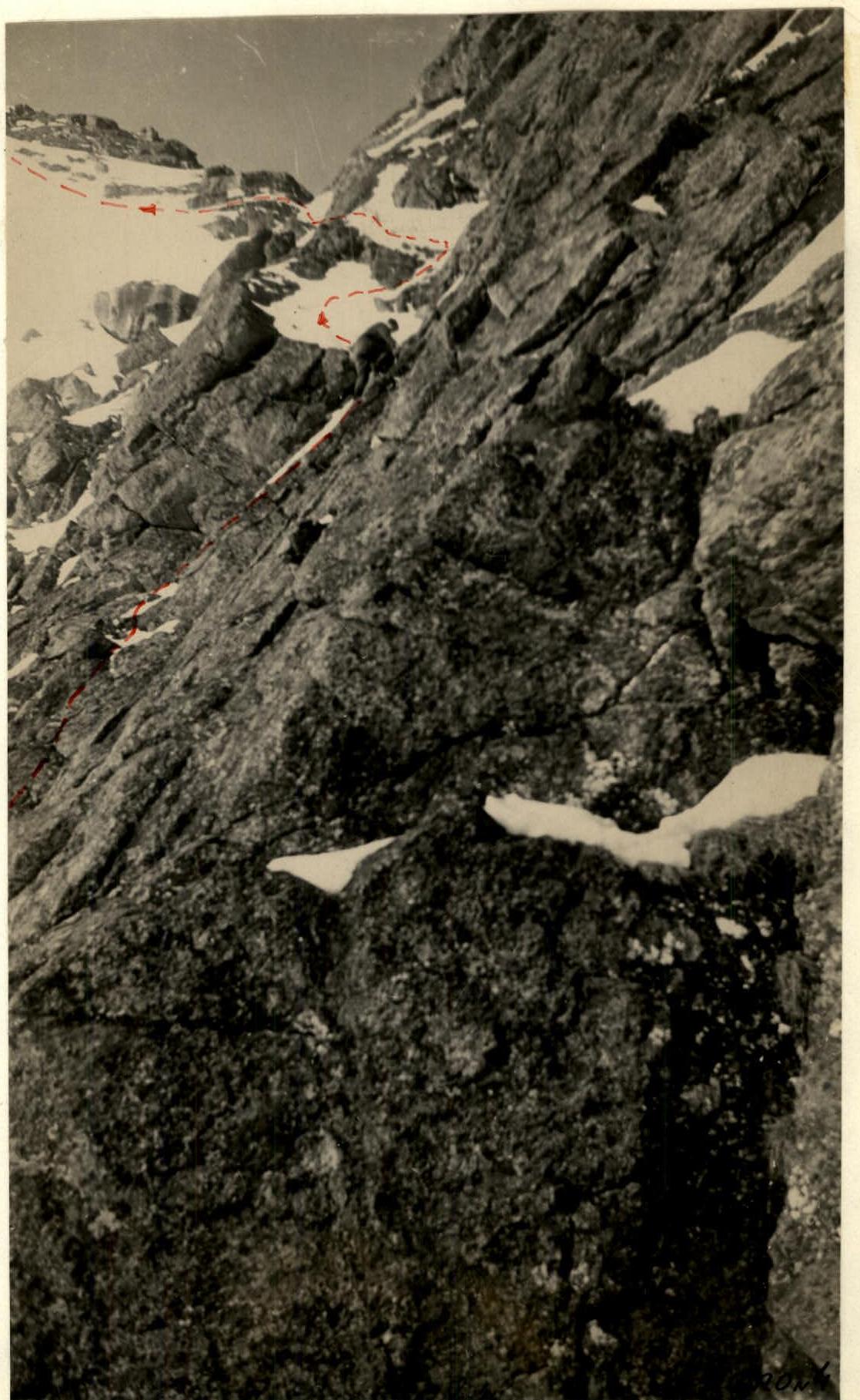
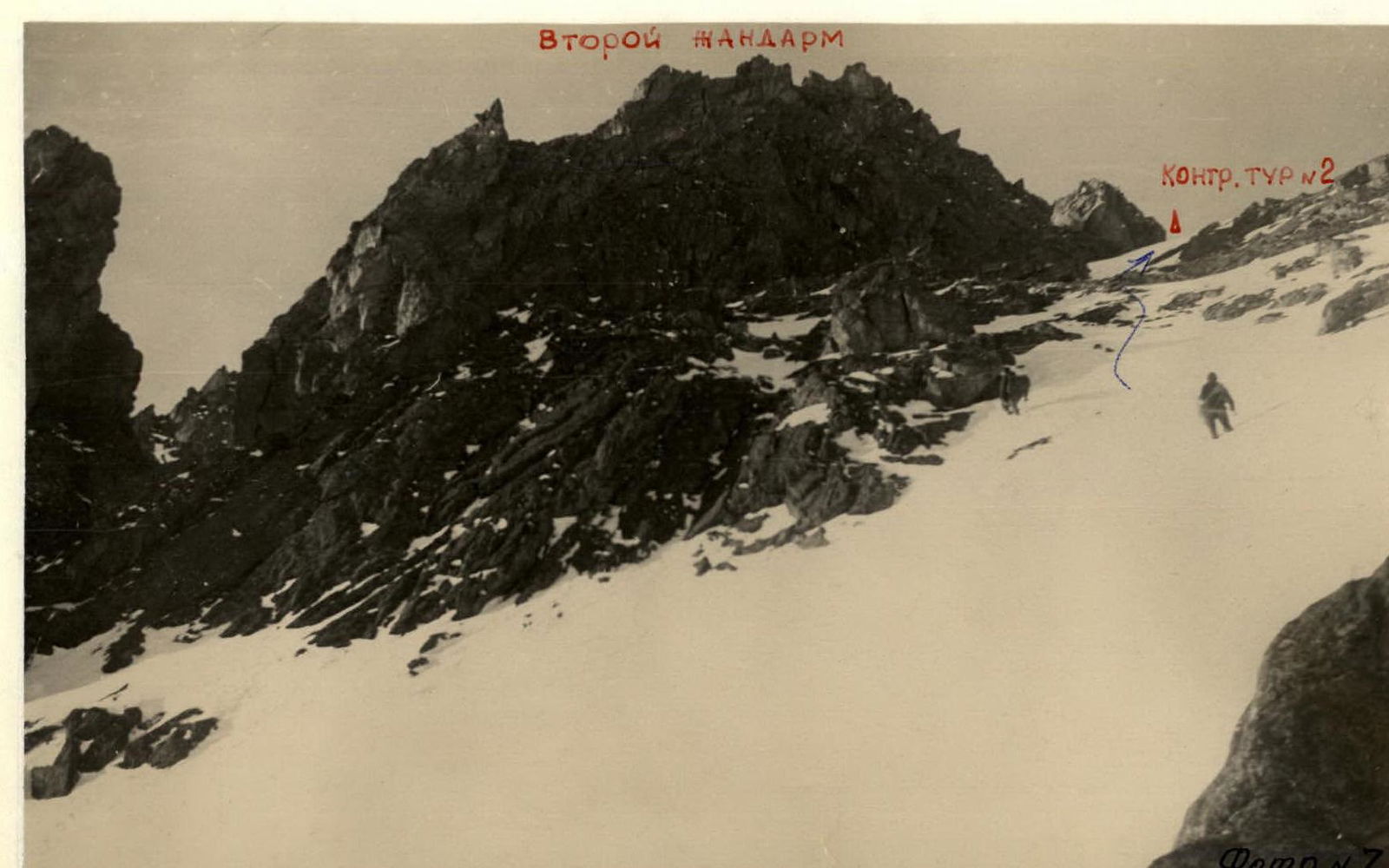
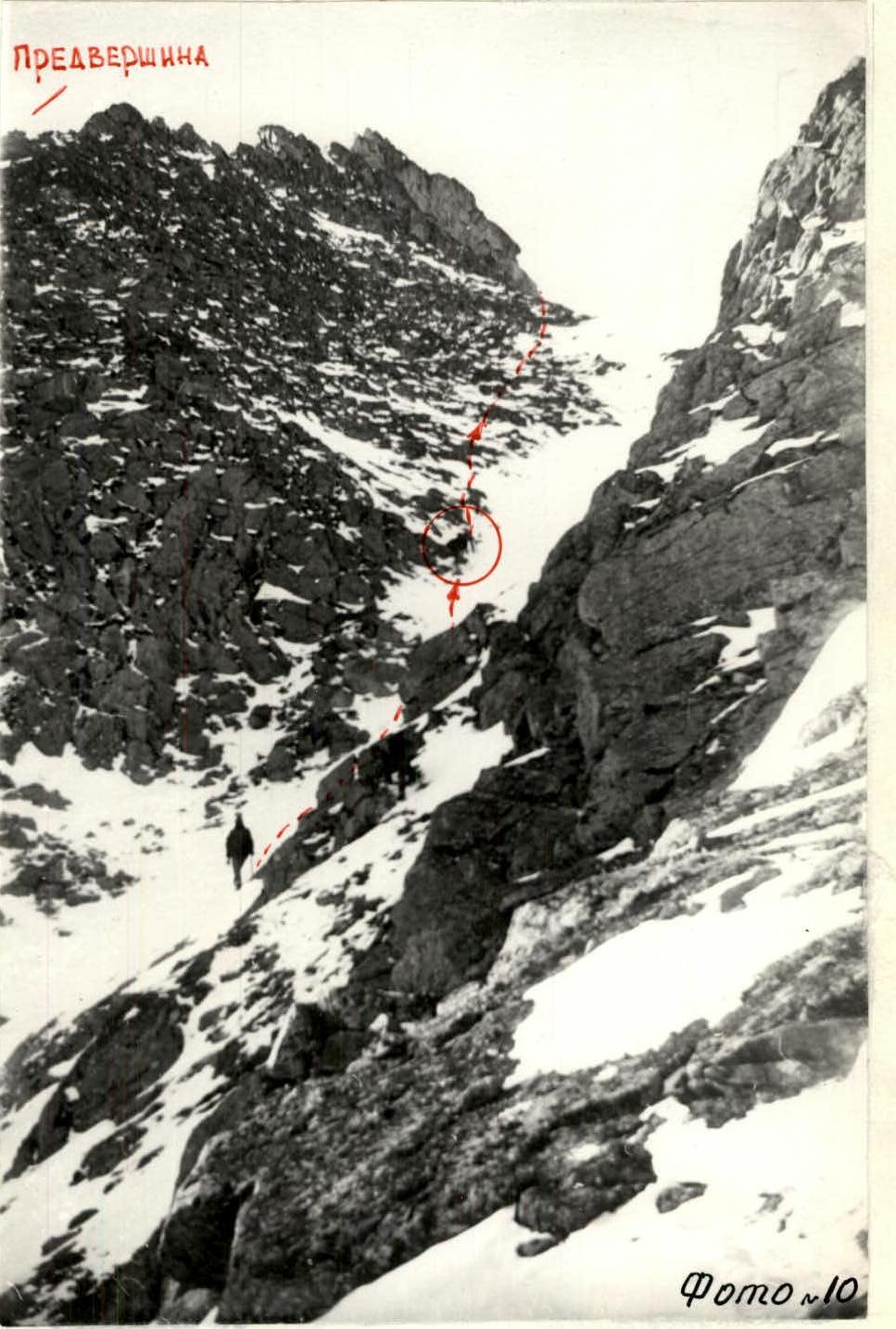 Photo 7.
 Photo 10.
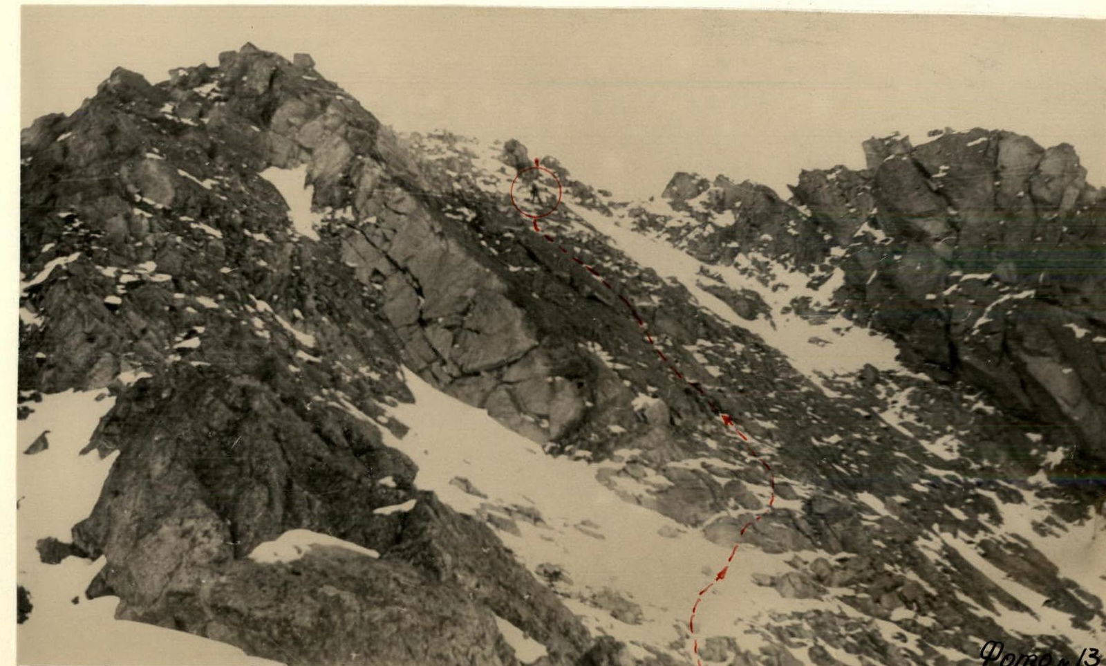 Photo 13.
 Central Tower from the north (Photo 15, 17, 18).
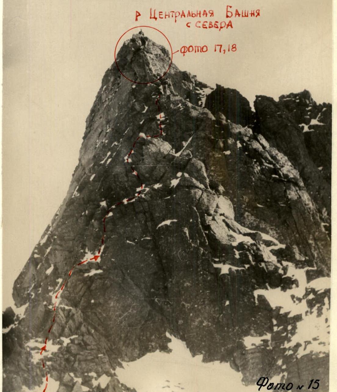
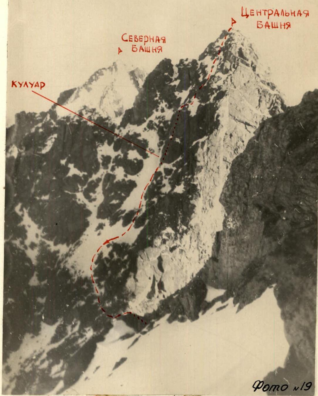 Photo 19.
Comments
Sign in to leave a comment