
Traversing the North and Central Towers
Trekhglavaya Peak with ascent via the NE ridge of the North Tower via route category 2B
1. Geographic information
The Trekhglavaya massif is located in the Tunka Goltsy range of the Eastern Sayan Mountains, in a long lateral spur that serves as the watershed between the Bugotoy and Kyngarga rivers.
The Tunka Goltsy range is the highest in the Eastern Sayan Mountains, stretching latitudinally for hundreds of kilometers. Its highest point, 3266 meters above sea level, is located in the upper reaches of the Ganga-Kharym river.
The range has sharp alpine forms overall. Within 100 km from the Arshan resort in the east to the Shumak pass in the west, there are many peaks of great interest to mountaineers.
The gorges are deep, covered with dense taiga. The tree line on southern slopes is at 1880 m, and on northern slopes at 1600–1700 m. Snow cover largely melts by the end of summer. There is no glaciation.
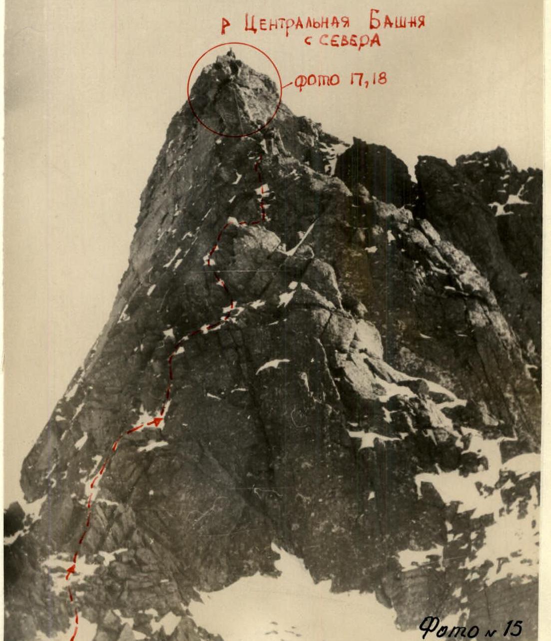
The Trekhglavaya massif consists of three towers: the South, Central, and North Towers. The highest is the Central Tower, at 2511 meters above sea level.
The nearest settlement is the Arshan resort, 225 km from Irkutsk. It takes 4 hours to reach the Base Camp at the confluence of the Right and Left Kyngarga rivers from the resort (upstream along the gorge).
2. Route description
From the campsite at the confluence of the Left and Right Kyngarga rivers (benchmark 1202 m) upstream along the Right Kyngarga river to the first stream on the left. Then along the stream with a gradual ascent to the right.
Near the tree line:
- dense thickets of bushes on very steep slopes.
Above the bushes:
- ascent to the ridge along snow-covered grassy slopes;
- above - snow-covered fine scree.
Then along a gentle but sharp ridge to the foot of the rocks. Here is the first control cairn. The start of the route (photo 1). It takes 2–2.5 hours from the campsite to reach this point.
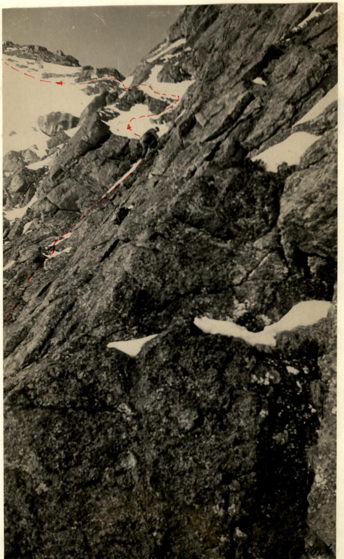
From the cairn, ascend through large rock fragments along the foot of the ridge rocks, which form a monolithic ridge. Then traverse a wide snow slope (40° steepness), which is overcome with alternate insurance through an ice axe, to reach the first pillar, to its narrowest middle part. The ridge of the pillar is traversed horizontally through monolithic rocks of medium difficulty in teams. Insurance is alternate through outcrops (photo 2).
A 5-meter wall is taken head-on, with 1 rock piton, self-insurance through outcrops (photo 3), vertical handrails, and a sport climbing ascent.
Then ascend monolithic rocks to the left and upwards (photo 4). Gradually move left to a wide snow couloir (photos 5, 6). Enter the couloir. The couloir is 30–35° steep, with 35–40 cm deep loose snow. Footsteps are difficult to make, it's slippery, insurance is partially alternate.
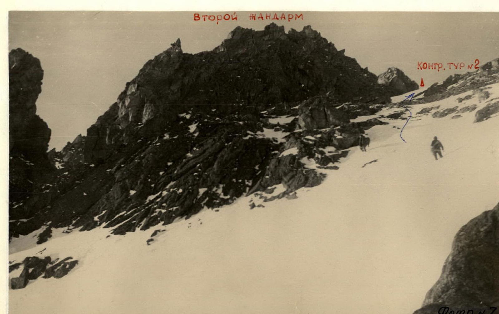
The couloir opens onto the ridge below the second pillar, where the 2nd control cairn is located (photo 7).
The second pillar is bypassed on the right via a wide ledge, exiting through an internal corner onto a narrow saddle between the rocks. The internal corner is 7–8 m long, 50° steep. Insurance is alternate through outcrops.
From the saddle, descend slightly to the left under overhanging rocks on loose deep snow (photo 8), with two ropes of handrails and 2 rock pitons.
After bypassing the rocks and overcoming a very steep (up to 50°) snow ascent of 1 rope length, traverse a wide snow slope with 35° steepness towards the foot of a group of rocks (photo 9). Traverse with altitude gain (photo 1, middle of section 3). Insurance is alternate through an ice axe.
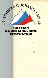
After bypassing the group of rocks, enter a wide couloir that leads to the ridge to the foot of the sub-peak (photo 10).
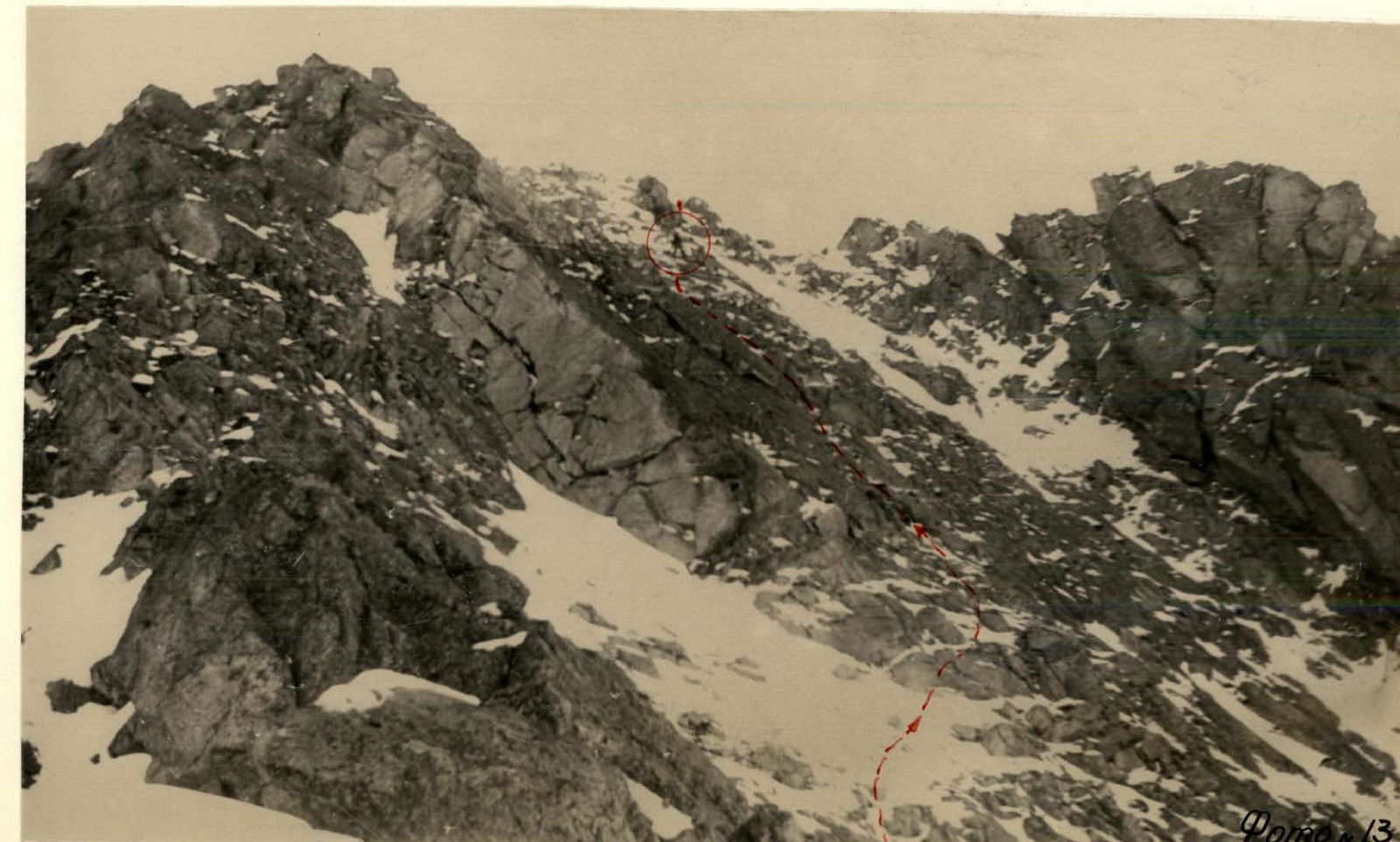
Then ascend to the right and upwards, bypassing the sub-peak rocks, which are easy to medium difficulty. Insurance is alternate. Rock steepness is 45–50°. Be cautious of loose rocks! (photos 11, 12, 13).
Reach the sub-summit ridge via rocks of medium difficulty; a 4 m wall is taken head-on with 1 piton. Ascend to the summit of the North Tower via a gentle ridge. There is a cairn on the summit. It takes 4.5 hours from the 1st cairn to reach the summit.
Descend to the ridge with two pillars between the North and Central Towers via a snow slope, then via easy rocks with simultaneous insurance (photo 14).
Ascend to the Central Tower with alternate insurance. Two ropes of difficult monolithic rocks form the key section (photos 15, 16, 17, 18).
Equipment:
- 2 rock pitons
- handrails with a prusik knot
The traverse from the North to the Central Tower takes 1 hour.
Descend to the saddle between the South and Central Towers:
- First, along the ridge via rocks of medium difficulty - 1 rope, insurance is alternate.
- Then descend into the couloir to the right:
- handrails - two ropes
- descent - via sport climbing
- 1 rock piton
Be cautious of loose rocks! (photo 19).
Exit to the saddle via snow-covered easy rocks. The descent from the Central Tower to the saddle takes 1 hour.
From the saddle, descend down a steep snow couloir. The upper part of the couloir is up to 60° steep.
Descent is via 1 rope of handrails, sport climbing with a prusik knot. Handrails are anchored at the top to a large convenient rock.
Then the couloir becomes gentler, at 45–40°. The section to point 1 (photo 1) is overcome with alternate insurance through an ice axe - 7–8 ropes. After exiting the narrow throat of the couloir, move simultaneously.
The entire route from the Base Camp and back takes 1 day.
3. Group composition
- Mikhailov A.A. - 2nd category - leader
- Popova L. - 2nd category + 3A, 3A, 3B
- Mikhailova R.T. - 2nd category + 3A, 3A, 3A
- Alekseev S. - 3rd category + 3A, 3A, 3A, 3B, 3B
- Palamarchuk S. - 3rd category + 3A, 3A, 3A, 3B, 3B
- Popova L. - 3rd category + 3A
4. Equipment
- Main rope - 3 × 40 m.
- Rock hammers - 2 pcs.
- Rock pitons - 5 pcs.
- Expendable cordelette - 5 m.
- Carabiners - 8 pcs.
- Ice axes - 6 pcs.
- Belay harnesses - 6 pcs.
- Cordelettes 4 m - 6 pcs.

Kyren–Irkutsk
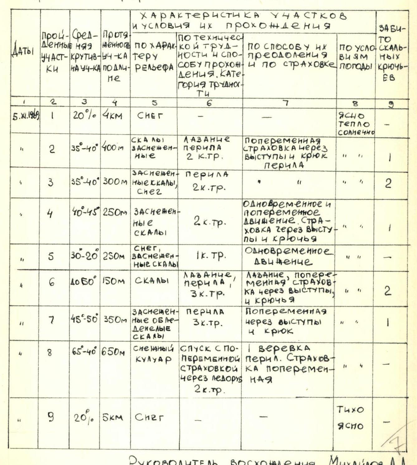
TABLE
MAIN CHARACTERISTICS OF THE ASCENT ROUTE
Ascent route - Traversing the North and Central Towers of Trekhglavaya Peak with ascent via the NE ridge of the North Tower via route category 2B.
Elevation gain: Base Camp - 1202 m - Central Tower - 2511 m above sea level. Route steepness - 40–45°
| Dates | Section | Steepness | Length | Terrain | Technical difficulty and passage method, category | Overcoming and insurance method | Weather | Rock pitons |
|---|---|---|---|---|---|---|---|---|
| 5.01.1969 | R1 | 20° | 4 km | Snow | Clear, warm, sunny | |||
| R2 | 35–40° | 400 m | Snow-covered rocks | Climbing, handrails, 2nd category | Alternate insurance through outcrops and pitons, handrails | «» | 1 | |
| R3 | 35–40° | 300 m | Snow-covered rocks, snow | Handrails, 2nd category | «» | «» | 2 | |
| R4 | 40–45° | 250 m | Snow-covered rocks | 2nd category | Simultaneous and alternate movement. Insurance through outcrops and pitons | «» | 1 | |
| R5 | 30–20° | 250 m | Snow, snow-covered rocks | 1st category | Simultaneous movement | «» | ||
| R6 | 40–50° | 150 m | Rocks | Climbing, handrails, 3rd category | Climbing, alternate insurance through outcrops, 4 pitons | «» | 2 | |
| R7 | 45–50° | 350 m | Snow-covered icy rocks | Handrails, 3rd category | Alternate insurance through outcrops, 4 pitons | «» | 1 | |
| R8 | 65–40° | 650 m | Snow couloir | Descent via sport climbing, alternate insurance through ice axe, 2nd category | 1 rope of handrails, alternate insurance | «» | ||
| R9 | 20° | 5 km | Snow | Calm, clear |
Ascent leader Mikhailov A.A.


Comments
Sign in to leave a comment