Ascent Log
- Climbing type — rock climbing.
- Climbing area — Eastern Sayan–Tunkin Goltsy, Kyngarga valley.
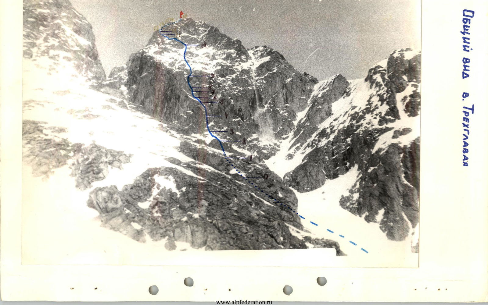
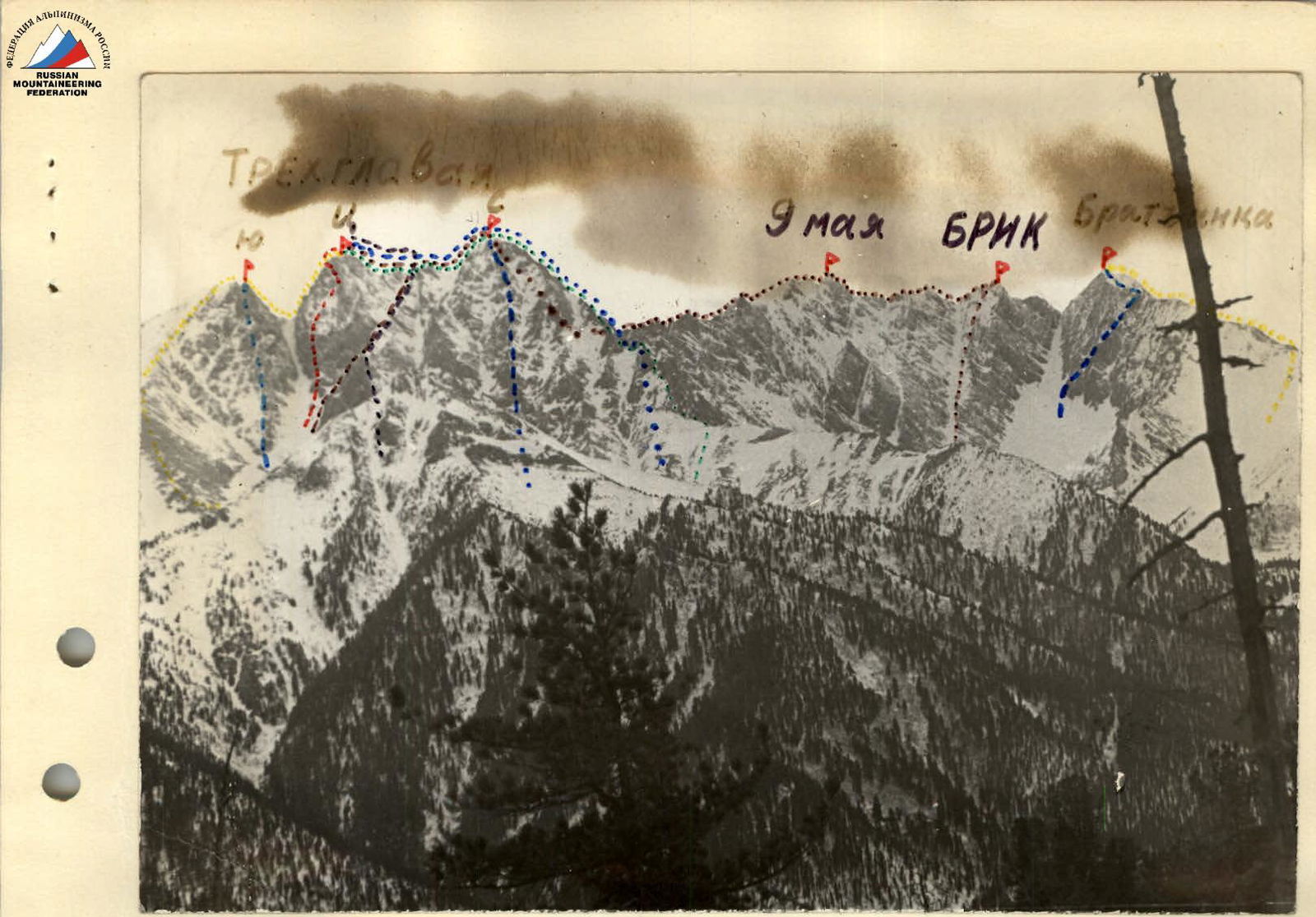
- Peak, its height, ascent route — Trekhglavaya, 2511, Central peak via the southeast wall.
- Estimated difficulty category — 4B.
- Route characteristics: elevation gain — 450 m.
Average steepness — 55° Length of section: 5–6 pitches — 24 m.
- Pitons hammered for belaying and creating artificial anchors:
Rock — 49, ice — none, bolted — none.
- Number of climbing hours — 10.
- Number of nights — none.
- Full name of the leader, participants, and their sports qualification:
leader AFANASYEV A.E. — CMS, participant AGAPONOV G.M. — CMS, participant TARAN N.S. — CMS, participant KRASNUKHIN L.I. — CMS.
- Team coach — BELOUSOV V.M.
- Date of departure and return — May 3, 1980.
General View of Trekhglavaya Peak
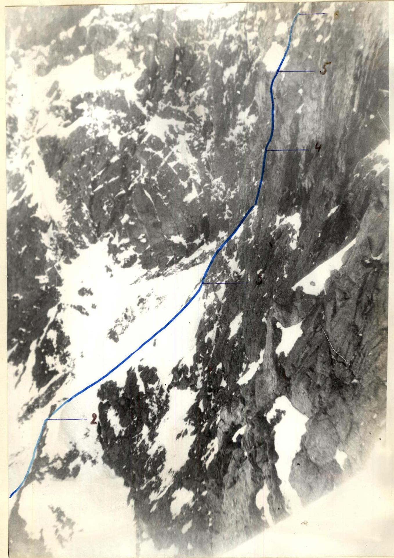
Lower Part of the Route Profile
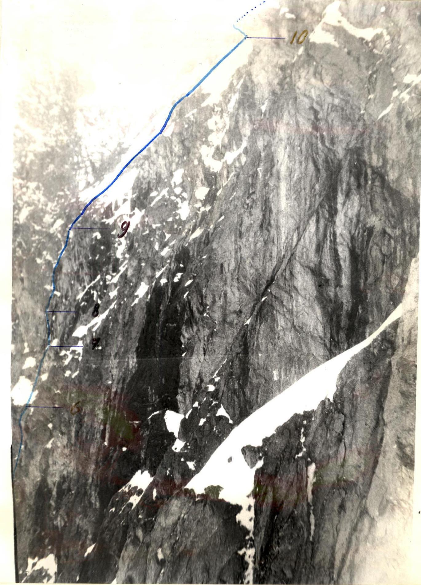
Upper Part of the Route Profile
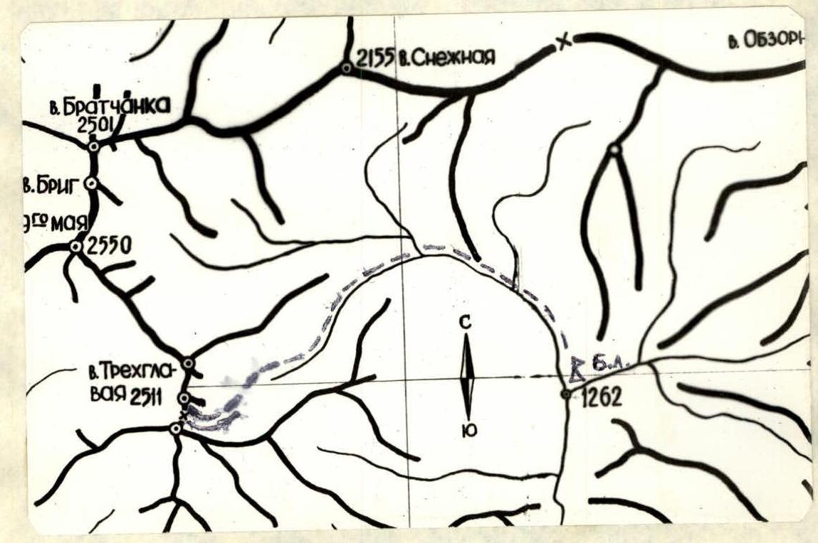
Map of the Climbing Area
Brief Description of the Approach to the Route, Sports Characteristics of the Area
Trekhglavaya peak is located in a spur of the main Tunkin Goltsy ridge, which is a watershed between the Pravy Bugotoy and Kyngarga valleys, with an elevation of 2511 m above sea level. The peak is the most popular in the area and has classified routes to all three peaks from different sides: 1B, 2B, three 3B, two 4A, and 4B difficulty categories. In May 1980, two more first ascents were made: to the North peak with an estimated 4A category difficulty and the described route to the Central peak with an estimated 4B category difficulty.
The Kyngarga valley, from which ascents to Trekhglavaya peak are made, is the most visited valley in Tunkin Goltsy and is also the most convenient and closest to a populated area. At the exit of the valley into the Tunkin valley is the Arshan resort, from which it takes 3–4 hours to reach the base camp at the confluence and 2–3 hours to reach the Trekhglavaya routes. Most of the approach path passes through cedar forest. The forest boundary in Tunkin Goltsy is generally at an elevation of 1700 m, but in this valley it rises to 1800 m and in some places to 1900 m above sea level. There is little snowfall in the area, and by the end of winter the snow cover reaches a thickness of 0.5–1 m. There are no glaciers in the area, but there are steep icings that persist until mid-June, where ice training can be conducted.
Table of Main Characteristics
Elevation gain — 450 m. Average steepness — 55°. Rock pitons hammered — 49.
| Designation | Average Steepness, ° | Length, m | Terrain Character | Difficulty | Condition | Weather Conditions | Rock | Ice | Bolted |
|---|---|---|---|---|---|---|---|---|---|
| R0–R1 | 45–50 | 40 | ridge | 2 | snow | - | - | - | |
| R1–R2 | 60 | 40 | wall | 3 | monolith | x | 3 | - | - |
| R2–R3 | 50 | 40 | ridge | 2 | snow | - | - | - | |
| R3–R4 | 60–65 | 20 | wall | 4 | destroyed | 0 | 2 | - | - |
| R4–R5 | 85 | 15 | chimney | 5 | monolith | 3 | - | - | |
| R5–R6 | 50 | 20 | slab | 4 | snow-covered | p | 1 | - | - |
| R6–R7 | 50 | 15 | slope | 4 | stepped | 1 | - | - | |
| R7–R8 | 95 | 5 | wall section | 6 | monolith | 0 | 1–3 | - | - |
| R8–R9 | 80–85 | 35 | gully | 4 | ice-covered | 6 | - | - | |
| R9–R10 | 45–50 | 120 | sheep's backs | 4 | snow, ice | Ш | 12 | - | - |
| R10–R11 | 50° traverse | 80 | system of ledges | 4 | snow-covered | 8 | - | - | |
| R11–R12 | 60–65 | 25 | couloir | 4 | snow-covered | и | 2 | - | - |
| R12–R13 | 85 | 5 | wall section | 4 | monolith | 1 | - | - | |
| R13–R14 | 45 | 10 | ridge | 2 | snow | e | - | - | - |
| R14–R15 | 90 | 4 | wall section | 5 | monolith | 1–1 | - | - | |
| R15–R16 | 55 | 30 | slab | 4 | snow, ice | 4 | - | - | |
| R16–R17 | 40 | 30 | ridge | 1 | snow | - | - | - |
Description of the Ascent Route
From the base camp to the route, it takes 3 hours to approach. The route begins from a characteristic rock under the southeast wall, along the left (orographic) side of the descent couloir. The first rope is on a snowy ridge with a steepness of 45–50° (R0–R1). 40 meters of rock of medium difficulty, 60° (R1–R2). The second snowy ridge (nose) is 40 meters, 50°, with the upper part up to 60° (R2–R3). Exit to the base of the wall. 20 meters of difficult 60° rock (R3–R4) under a chimney-like gap. The gap is inclined and separates a large fragment from the wall. Its steepness is 85°, length is 15 meters, and in the lower part it is climbed inside with opposition, and in the upper widening part, along the left wall face, using protruding frosty grassy tufts (R4–R5, ice accretion, icicles on the right overhanging face). Very difficult. Next is a large internal corner, the left face of which is a snow-covered slab 20 m, 50° (R5–R6). Along the slab and further 15 meters along stepped 55° rock (R6–R7) under an overhanging 5-meter wall. Climbing is very difficult, using chocks and ladders. The key to the route (R7–R8). Behind the overhang is a control cairn. Then 35 m of 80–85° rock gully with ice accretion (R8–R9). Not reaching 10 m to the top of the gully, move right onto a steep 55° snow-rock slope. The seventh and eighth ropes are up the slope (partly ice) and sheep's backs towards the center of a huge internal corner of the pre-summit wall. The ninth rope is along a vaguely expressed snowy ridge with a steepness of up to 60°, which abuts the wall slightly left of the middle of the internal corner (R9–R10). To the left along the traverse is a system of sloping (50°) snow-covered ledges — "scarf." Along it, 2 ropes traverse to the corner (R10–R11), to a snow-covered, partly ice-filled rock couloir with a steepness of 60–65°, 25 m long (R11–R12). At the top of it is a 5-meter, 85° wall section (R12–R13). The entire couloir to the exit onto the ridge is 30 meters. Along the ridge, 10 meters under a wall section (R13–R14). A rock wall section 4 m, 90° is climbed with the help of a ladder (R14–R15). Then along smooth, steep slabs, snow-covered and ice-covered, left and up with piton belay, one rope to the exit onto the 1B category difficulty route ridge (R15–R16). Along it, 30 meters to the summit (R16–R17).
Descent is along the 1B category difficulty route to the saddle between the South and Central peaks of Trekhglavaya and then down the couloir towards the Kyngarga valley.
The group spent 10 hours on the ascent and 3 hours on the descent from the summit to the base camp. Despite the short length, the route's technical difficulty, according to the group's assessment, corresponds to the 4B category difficulty.
On the route, rock pitons of various types and even chocks were used for belay and climbing. As a recommendation to subsequent climbers — it is desirable to have bolts. Team leader: A. Afanasyev.
Routes
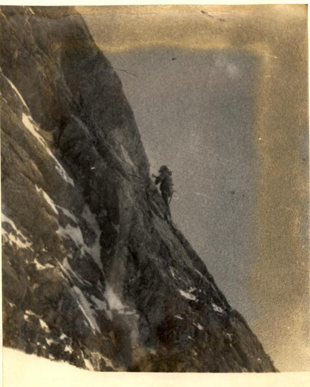 Start of section R9–R10