Traverse of South Tower v. Trekhlavaya via 1B category difficulty route, Tunkinskie Goltsy ridge in Eastern Sayan
1. Geographical information
The v. Trekhlavaya massif is located in the Tunkinskie Goltsy ridge in Eastern Sayan, in a long lateral spur serving as a watershed for the Bugotoy and Kyngarga rivers.
Tunkinskie Goltsy is the highest ridge in Eastern Sayan, stretching in a latitudinal direction. The highest point is 3266 m, located in the upper reaches of the Gang-Kharym river gorge.
The ridge has sharp alpine forms. Within 100 km from the Arshan resort in the east to the Shumak pass in the west, there are many peaks of great interest to mountaineers.
The gorges are deep, covered with dense taiga. The forest boundary on the southern slopes is at 1880 m, on the northern slopes at 1600–1700 m. The snow cover almost completely melts by the end of summer. There is no glaciation.
The v. Trekhlavaya massif consists of three towers — South, Central, and North. The highest is Central, with an elevation of 2511 m above sea level. The height of the South Tower is 2486 m above sea level.
The nearest settlement is the Arshan resort, 225 km from Irkutsk. From the resort to the base camp at the confluence of the Right and Left Kyngarga rivers, it takes 4 hours to ascend the gorge.
2. Route description
From the campsite at the confluence of the Right and Left Kyngarga rivers (at benchmark 1202 m above sea level) upstream along the Right Kyngarga river to the first stream flowing in from the left. Then follow the stream to the forest boundary. Along the way, one has to overcome dense thickets of bushes, sometimes on very steep slopes.
From the forest boundary, which is about a 2-hour walk, cross the snow-covered moraines of the cirque to the foot of the South Tower's ridge. The direction of movement is towards the couloir leading to the Southeast ridge, which bounds the rocky massif of the peak on the left (photo 1). From the forest boundary to point I, it takes 35–50 minutes.
Then proceed up the couloir, along the snow-covered scree with rock outcrops. The rocks are easy, and the movement is simultaneous. In the upper part, the couloir narrows and becomes steeper, reaching 40° (photos 2, 3). The couloir leads to the wide eastern slope of the peak. Move along the moderately expressed ridge with a slope of 25–30° (photos 4, 5). Continuing upwards, reach the pre-summit ridge in 45 minutes, consisting of small, easy rocks that are traversed with simultaneous belay through outcrops.
The summit is a wide dome with remnants of destroyed rocks. The entire path from point I to the summit takes 3 hours.
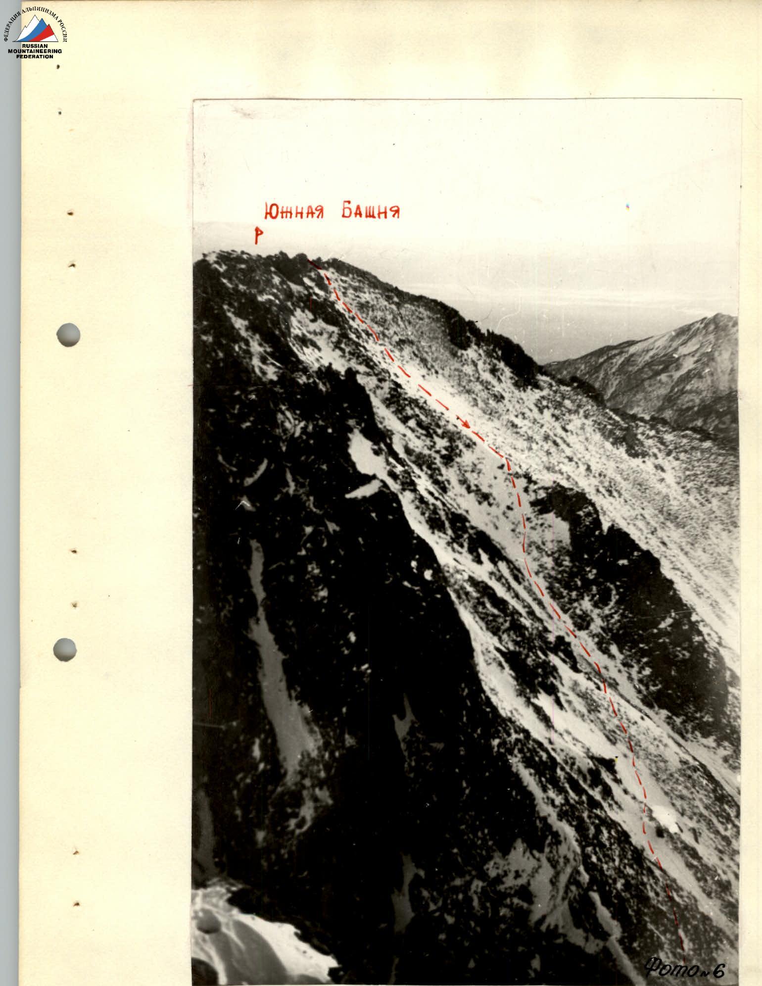
Descent to the northwest, initially along the ridge, bypassing and overcoming easy rocks with simultaneous and alternating belay, then down the steep snow-covered scree to the saddle between the South and Central Towers (photos 6, 7). The slope is 30–40°. Caution is advised due to loose rocks! The descent to the saddle takes 1 hour.
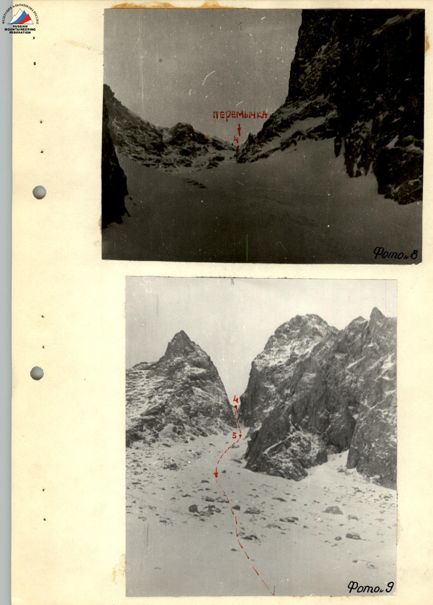
From the saddle, descend down the steep snowy couloir. The upper part of the couloir is up to 60°. The descent is done using one rope with a running belay in a sports style with a Prusik knot. The rope is anchored at the top to a large, convenient rock.
Further down, the couloir becomes less steep, at 45–40°. The section to point 5 (photos 8, 9) is traversed with alternating belay using an ice axe for 7–8 ropes. After exiting the narrow throat of the couloir, the movement becomes simultaneous (photos 8, 9).
The entire ascent requires 9–10 hours.
3. Group composition
- Mikhailova R.T. — 2nd sports category
- Mikhailov A.A. — 3rd sports category
- Palamarchuk S. — 3rd sports category (ЗАЗАЗАЗБЗБ)
- Popova L. — 3rd sports category (ЗА ЗА ЗБ)
4. Equipment
- Main rope — 2 × 40 m
- Carabiners — 4 pcs
- Belay harnesses — 4 pcs
- Repschnur 4 m — 4 pcs
- Ice axe — 4 pcs
Table of main characteristics of the ascent route
Elevation gain — base camp 1202 m, South Tower 2486 m. Steepness of the route — 25–40°.
| DATES | SECTION-KN | Steepness | Length | Terrain characteristics | Technical difficulty / Category of difficulty | Method of overcoming / Belay | Weather conditions | Number of pitons driven |
|---|---|---|---|---|---|---|---|---|
| 1 | 2 | 3 | 4 | 5 | 6 | 7 | 8 | |
| 7119691 | 1 | 20% | 4 km | Snow | — | — | Haze, light wind | — |
| 2 | 30–40 | 1000 m | Snowy couloir with rock outcrops | 1st cat. diff. | Simultaneous movement | Wind, snow, cold | — | |
| 3 | 25° | 300 m | Snow-covered large scree | 1st cat. diff. | " " | " " | — | |
| 4 | 30–40 | 350 m | " " | " " | " " | " " | — | |
| 5 | 65–60 | 350 m | Snowy couloir, deep snow | Descent with alternating belay, 2nd cat. diff. | One rope with running belay, belay alternating through ice axe | Wind, snow | — | |
| 6 | 40–30° | 600 m | Snow-covered scree | 1st cat. diff. | Simultaneous movement | " " | — | |
| 7 | 20–10° | 4 km | Snow | — | — | Light wind, light snow | — |
Ascent leader: Mikhailova R.T.
www.alpfederation.ru↗
 www.alpfederation.ru↗
 Kyren — Irkutsk