Ascent Record
Climbing category: technical. Region: Eastern Sayan, Tunka Ridge. Route: first ascent via the central counterfort of the eastern wall of the Northern tower of v. Trekhglavaya.
Route characteristics: height difference 700 m, average steepness 55°. Number of pitons: rock 23 pcs., ice none, bolted none. Duration 9 hours. Number of bivouacs: none. Leader: Akhmedzhanov S.N., 1st sports category. Team members: Belov S.V., 1st sports category; Galygo A.N., 1st sports category; Donskoy K.D., 1st sports category; Zuev V.A., 1st sports category; Savin V.V., 1st sports category. Team coach: Popov V.N., Master of Sports, instructor.
Date of ascent: March 4, 1980, Irkutsk
Map of the Trekhglavaya Peak Area
Brief Geographical Overview of the Area, Sporting Characteristics
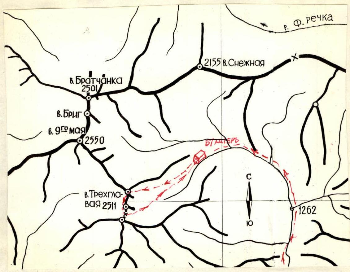
The Trekhglavaya peak massif is located in the southeastern ridge of the Tunka Ridge of the Eastern Sayan, in a long lateral spur that serves as a watershed between the Bugotoy and Kyngarga rivers.
The Tunka peaks are the highest part of the Eastern Sayan. The highest point, 3266 m, is located in the upper reaches of Gang-Khairym.
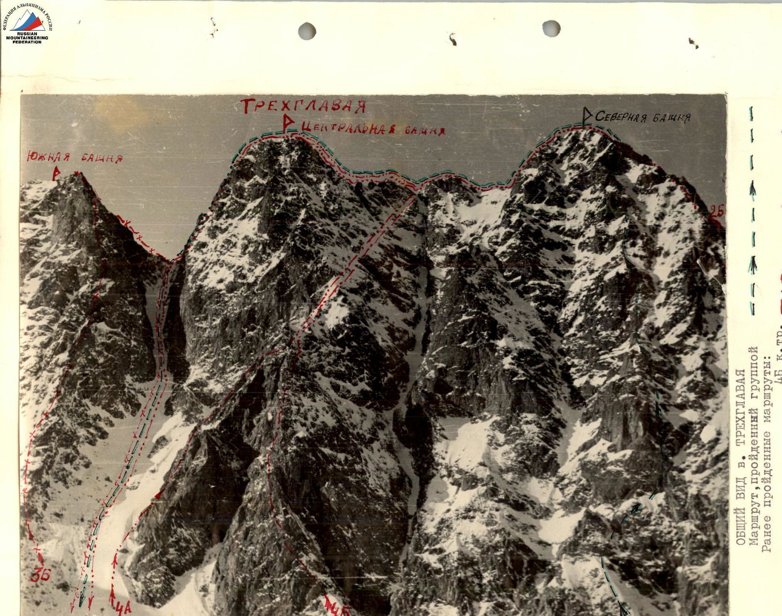
The Trekhglavaya peak massif consists of three towers:
- Southern,
- Central,
- Northern.
The highest tower is the Central one, with an elevation of 2511 m above sea level. There are classified routes 4B, 4A, 3B, 2B, and 1B category of difficulty in the Eastern cirque of v. Trekhglavaya.
The approach to the base camp starts from the Arshan resort along the Kyngarga river valley to the confluence of the Right and Left Kyngarga rivers. Here is an old hunting lodge, which takes about 4 hours to reach.
From the lodge:
- Ascend along the right (orographic) tributary of the Kyngarga River - 1 hour;
- Turn left into the gorge, from which the Trekhglavaya peak massif comes into view;
- Then ascend along the stream to the base camp - about 30 minutes.
The base camp is located just below the tree line, which is at an elevation of 1800 m above sea level.
The area is characterized by:
- Unstable weather conditions;
- Harsh climate;
- Short summer.
There are no glaciers in the area.
In summer, the routes to v. Trekhglavaya are rock routes; in winter, they are combined with sections of formed ice.
Route Description
From the base camp, located at the forest boundary, ascend along the stream to the Eastern cirque of v. Trekhglavaya. Then move along the slopes of the Northern tower towards the central counterfort.
The first section of the route (sect. R0–R1) is a steep, snowy slope. Movement is simultaneous here, becoming alternating in the upper part. The length of this section is 80 m (see photos 1 and 2).
The route then proceeds through:
- Broken rocks (sect. R1–R2);
- Steep snow
in the direction of bypassing a large, rusty, triangular wall, which is done from the right. Movement on this section is alternating. Piton protection. Ropes (see photo 3).
A traverse under the rock leads to a chimney (sect. R2–R3). The chimney is climbed with piton protection. Ice formation! The chimney widens at the top (see photo 4). Ropes.
- Further movement is across snow-covered slabs resembling "ram's foreheads". Piton protection.
- Sections of steep snow are encountered.
- Ropes (see photo 5).
- This section (sect. R3–R4) is marked by a sharp change in the route's character: transitioning from rocks to snow and back.
- Gradually, moving left, we reach the crest of the counterfort.
- Alternating movement.
- Piton protection and rock outcrops.
Next is a 40 m long, sharp, knife-like ridge followed by a small 3–4 m drop (sect. R4–R5). Alternating movement, protection through rock outcrops.
Then, along steep, broken rocks, movement is simultaneous and alternating, using rock outcrops and pitons for protection. The rocks are snow-covered (sect. R5–R6).
A slight general flattening follows. Some sections are steep. Movement along the ridge leads to a standalone rock outcrop on the path, about 2 m high. Cairn (see photo 6).
After the cairn, directly ahead - a rock ascent. Piton protection (sect. R7–R8) (photo 7).
And then 80 m of movement along broken rocks leads under a rusty tooth, which is bypassed from the right (sect. R8–R9).
The next section passes over snow-covered slabs. Alternating movement. Piton protection (sect. R9–R10).
Then movement is along the pre-summit ridge, simultaneous. After 80 m - the summit.
Descent is via the Central tower, on the ridge between the Southern and Central towers of Trekhglavaya, following route 2B category of difficulty, then down a snowy couloir to the base camp.
The group left the base camp at 7:00, approached the route in 1 hour, reached the cairn by 14:00, and the summit of the Northern tower by 16:00. The group returned to the base camp by 18:00.
- 23 pitons were used on the route.
In terms of difficulty, length, and weather conditions, the group assesses the route via the central counterfort of the Eastern wall of the Northern tower of v. Trekhglavaya as a 3B category of difficulty route.
Group leader S. Akhmedzhanov
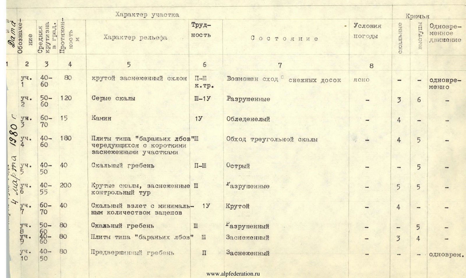
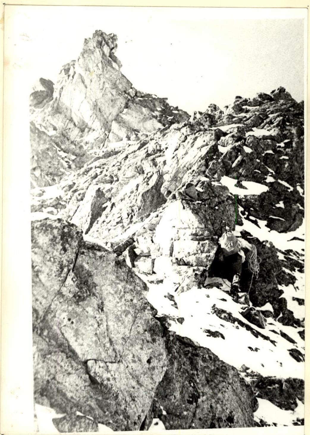
Photo 6. Section R5–R6.
Table of Main Route Characteristics
| Section # | Steepness, ° | Length, m | Terrain Characteristics | Section Difficulty | Condition | Weather Conditions | Pitons (rock) | Pitons (through outcrops) | Simultaneous Movement |
|---|---|---|---|---|---|---|---|---|---|
| sect. R1 | 40–60 | 80 | Steep snowy slope | 2–3 | Possible snow slab avalanches | clear | – | – | simultaneous |
| sect. R2 | 50–60 | 120 | Grey rocks | 3–4 | Broken rocks | 3 | 6 | – | |
| sect. R3 | 60–70 | 15 | Chimney | 4 | Icy | 4 | – | – | |
| sect. R4 | 40–60 | 180 | Slabs like "ram's foreheads", alternating with short snowy sections | 3 | Bypass of triangular rock | 4 | 5 | – | |
| sect. R5 | 40–50 | 40 | Rocky ridge | 2–3 | Sharp | – | 5 | – | |
| sect. R6 | 40–55 | 200 | Steep rocks, snow-covered, cairn | 3 | Broken rocks | 5 | 5 | – | |
| sect. R7 | 60–70 | 40 | Rock ascent with minimal holds | 4 | Steep | 4 | – | – | |
| sect. R8 | 50–60 | 80 | Rocky ridge | 3 | Broken | 5 | – | – | |
| sect. R9 | 40–60 | 80 | Slabs like "ram's foreheads" | 2 | Snow-covered | 3 | 4 | – | |
| sect. R10 | 40–50 | 80 | Pre-summit ridge | 2 | Snow-covered | – | – | simultaneous |