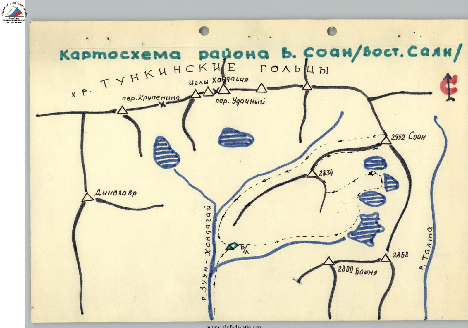
Brief Geographical Overview of the SOAN Peak Area
The SOAN peak (Siberian Branch of the Academy of Sciences) is located in the eastern part of the Tunkinskie Goltsy ridge in the Eastern Sayan Mountains. The ridge is clearly stretched from west to east for 150 km and approaches the southwestern tip of Lake Baikal.
Streams and rivers flowing from the ridge flow into:
- to the south (in the Tunka valley) — into the Irkut River,
- to the north (in the Kitoi valley) — into the Kitoi River.
Kitoi and Irkut are left tributaries of the Angara River.
The Tunka valley has many mineral springs, one of which is Arshan, which has gained all-Union fame. The wildlife in the area is rich and diverse.
The Tunkinskie Goltsy ridge is located on the territory of the Buryat ASSR.
The SOAN peak is located in the upper reaches of the Zun-Khandagai River gorge.
Climatological Information
The climate of the area is sharply continental. In the valley, the average temperature of the winter months is low (up to −40 °C), the minimum temperature in the mountains is 5–10 °C higher. In summer, cloudiness and precipitation increase in the mountains compared to the valley, and the air temperature decreases. Large temperature fluctuations are characteristic throughout the day.
In winter, weak southwest or southeast winds prevail. In summer, due to the passage of western cyclones, northwest winds prevail.
The amount of precipitation in mountainous areas:
- in the warm period reaches 500 mm;
- in winter 600–1000 mm. The greatest height of the snow cover is in late February - early March.
The snow line passes at an altitude of 2900 m. The transition of the average daily temperature through 0° in spring occurs after May 10, in autumn - in early October. The winter period is from October 10 to May 15.
From November to mid-May, the rivers of the Sayan are ice-bound, and deep, loose snow lies in the gorges. By May, some open snowfields become firn, but mostly the snow retains its looseness until it melts. There are:
- ice fields along the river gorges,
- icings until mid-July.
Numerous high-altitude lakes are fully opened in July. There is no glaciation in the peak area.
Hazards
Hazardous phenomena in the mountains:
- low temperature,
- winds (sometimes with snow even in July),
- snow avalanches (especially hazardous from February to May).
Rockfalls are rare, but heavily destroyed rocks are hazardous when moving carelessly, especially in couloirs.
Travel to the Area. Approach to the Base Camp
Travel from the city of Irkutsk is by bus to the Arshan resort, by passing cargo vehicles on a dirt road to the Tagarkhai village and further to the dry bed of the Zun-Khandagai River.
If there is a hired vehicle, it is not necessary to enter Arshan: the turn to Tagarkhai is 5 km before Arshan.
When traveling from Tagarkhai to the Zun-Khandagai riverbed, it is advisable to have a guide.
Further transportation of cargo is possible:
- on one's back in backpacks,
- by helicopter,
- using pack transport, especially in summer, by agreement with the local population.
From the clearing upstream along the Zun-Khandagai River gorge, initially along a trail, then the trail disappears, and one must go along the left orographic bank of the river. At the beginning, the riverbed is dry, and after 1.5 hours of walking, water appears. At the beginning of the gorge, the river does not freeze in some places; in the upper reaches, it is hidden under ice and snow (late October - May).
The slopes are difficult to traverse, overgrown with trees and bushes, and in some places rocky and talus. Therefore, it is recommended to walk most of the way along the river.
The path along the river is complicated by the presence of large boulders, and in some places, movement turns into climbing, complicated by backpacks.
The gorge is long and can be traversed in 1-2 days (depending on the group's composition and the state of the snow cover).
The recommended location for the base camp is at the confluence of the Zun-Khandagai River into the left and right tributaries, near the forest boundary. The forest boundary is at an altitude of 1800–1900 m. The specified base camp location is convenient due to the presence of firewood and the possibility of accommodating a large team.
Description of the Route along the Southwest Ridge of SOAN Peak (2952 m)
Date of ascent: May 1–4
From the base camp (1800 m), located at the confluence of the Zun-Khandagai River at the forest boundary, the group needs to move up to the southern wall of SOAN peak to organize an assault camp. (See diagram).
The path goes up along the left river (orographically) past large high-altitude lakes. The lakes are separated from each other by powerful ascents consisting of large stones, boulders, and rocks. Movement is difficult due to depressions between boulders filled with snow. The path along the lakes passes directly across the ice and drifted snow.
The ascents are steep, and one has to gradually gain height, traversing along the slope. The ascent to the first lake, resembling a flattened animal skin, gives a height gain of 350 m. The ascent from the first lake to the second rises by 250 m, and it is recommended to bypass the seemingly small peak behind the lake from the left side along the direction of movement.
From the second lake, there is an ascent of 100 m, consisting of rock fragments and a rocky slope.
The third lake resembles an elongated droplet from above, and when ascending to this rise, the view of SOAN peak opens up.
Next, it is necessary to pass along the frozen lake and set up an assault camp between the third and fourth lakes among huge rocks.
The ascent between the third lake and the last fourth lake does not exceed 10 m.
The journey from the base camp to the assault camp takes 3.5–4 hours.
Section R0–R1
From the assault camp along the snow-covered talus slope to the left towards the Southwest Ridge. Further along a narrow, not deep couloir to the ridge, into a small depression. Then along the ridge towards the peak.
Section R1–R2
Along a not wide ridge with rock outcrops, continue to move. Movement is simultaneous, with rope protection through outcrops.
Section R2–R3
The first gendarme is bypassed on the right. Very jagged rocks, alternating protection through outcrops. Move with a slight gain in height into the depression between gendarmes.
Section R3–R4
The second gendarme. From the saddle between gendarmes, descend 10 m and bypass the second gendarme along talus and rocky ledges on the left. The exit to the ridge is a 10 m wall. Hook protection is necessary. Further along the ridge for 15–20 m.
Section R4–R5
The third gendarme. Bypassed on the right by traversing under a red overhanging block. Then traverse up to the right to a slab. The slab is overcome by a horizontal narrow crack using counter-pressure for approximately 3 m. Exit to the ridge. Along the ridge for 25 m (alternating protection) and further along a narrow ledge on the right, up to the ridge, and then along the ridge to gendarme IV.
Section R5–R6
Gendarme IV is bypassed on the right. Traverse below the red belt. Alternating protection through outcrops. Further up to the ridge to gendarme V.
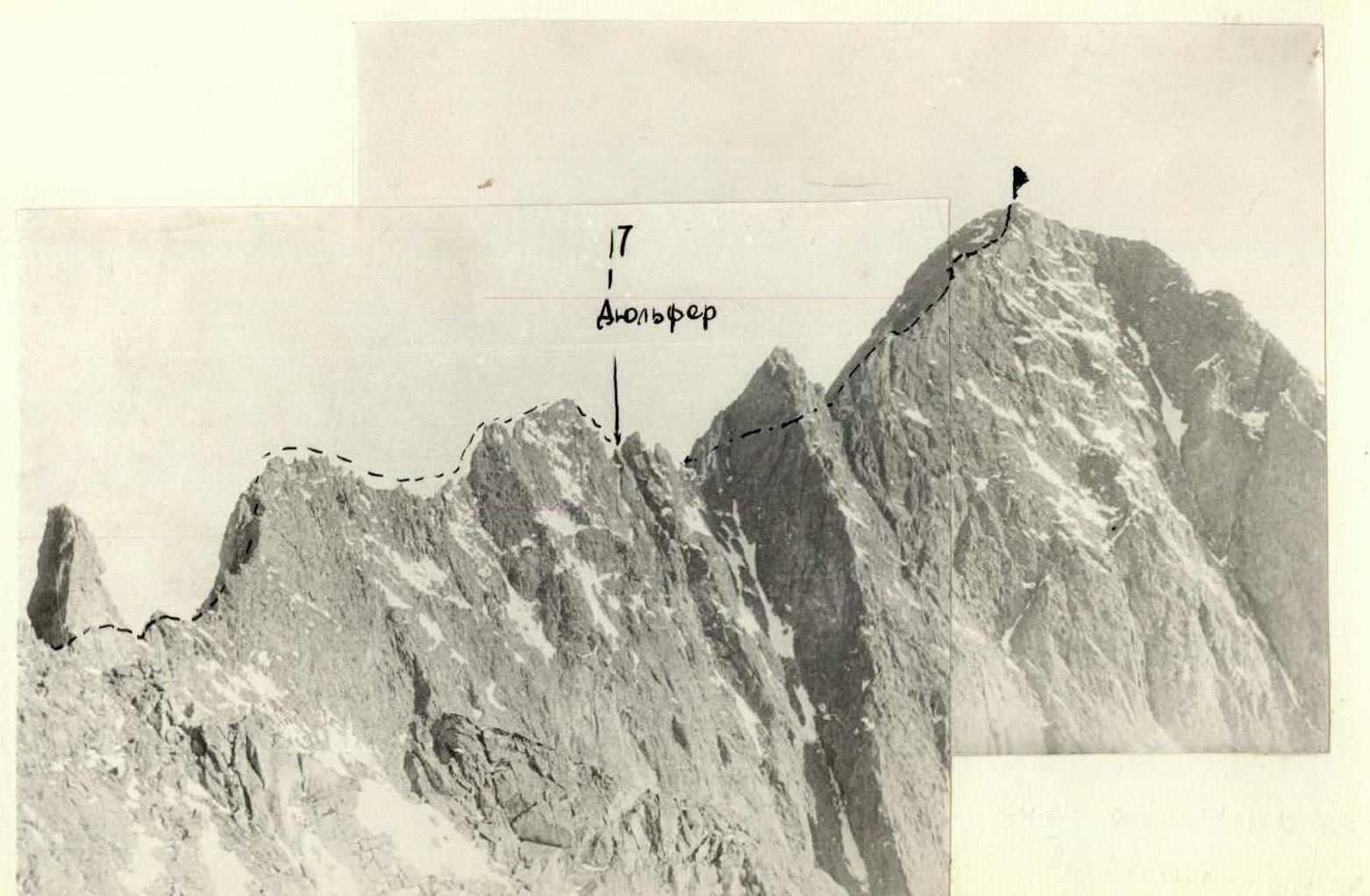
Section R6–R7
Climb directly, to the right of the gray slab, not reaching 5–6 m to the gendarme, and bypass it on the left along ledges (hook protection, Be careful, destroyed rocks!).
The bypass goes with a loss of height towards the ridge. The ridge changes direction, from this moment on, it has a strict orientation to the southwest. Then traverse to the right to gendarme "IGLA" VI.
Section R7–R8
Along a wide talus ridge simultaneously towards gendarme VI ("IGLA").
Section R8–R9
At the base of the gendarme on the right, descend along a short chute 50 m (50°). Rappel is set up. Further, traversing a steep rocky slope, to the saddle between gendarmes - approach to gendarme "Karandash".
Section R9–R10
The gendarme is bypassed on the right. Descend 15 m to slabs and immediately up to the next rocky outcrop from the ridge. Bypassed on the right. Descend along a rope 20 m towards a depression in the ridge and along a talus slope - descend into the depression.
Section R10–R11
From the depression along the ridge, the ridge has protruding rocky sections. Passed by easy climbing with alternating protection through outcrops. In some areas, simultaneous movement is possible.
Section R11–R12
Further, the ridge has two rather steep ascents. The relief is represented by rock outcrops with small walls. The rocks have many outcrops. The section is passed alternately with protection through outcrops.
Section R12–R13
The ridge becomes narrow with steep slopes on both sides towards the valleys. The rocks are very destroyed; protection is provided by placing a rope around outcrops.
Section R13–R14
Represents a very narrow ridge, requiring careful passage. In some areas, movement is on top of the ridge (rooster). Hook and outcrop protection. (Photo 3,4)
Section R14–R15
Further, the ridge becomes slightly wider. Ahead, a small ascent to the next elevation on the ridge is visible. Blocky rock structure. Deep cracks and depressions between rocks are filled with snow. Protection through outcrops.
Section R15–R16
After a slight descent, again up along the ridge to the next elevation on the ridge. Rocks are destroyed and covered with snow. Protection through outcrops, alternating movement. Descent by climbing; the ridge lowers.
Section R16–R17
A very narrow ridge leads to a rocky spire. Protection through hooks and outcrops; one has to move sitting on top of the ridge. To the left of the spire, there are three crevices; move along the middle one and, bypassing the spire on the left, exit to the opposite side of the spire, onto a ledge. The ledge is formed by this crevice (ledge is only for four people, 0.7 m × 1.5 m). From here, rappel directly into the depression 25 m. In the depression lies a plug. "Be careful, the rock is loose!" (Photo 4,5)
Section R17–R18
From the depression directly up along the crevice. Wall 10 m. Steepness 80°. Further, a narrow destroyed ridge. Protection through hooks and outcrops. On the ridge, a bivouac was organized. There is no platform for a tent. Bivouac sitting, in a stretched tent, on a small ledge. (Photo 6)
Section R18–R19
From the bivouac further along the ridge, losing height, to the base of the "Big Gendarme". Then, bypassing it on the left, climb onto a small rib extending in a northwest direction.
From this rib, descend along a narrow inner corner 10 m and, traversing the slope, move towards the depression behind the gendarme. Climb into the depression along the inner corner. Be careful, many loose rocks. Everything is filled with snow. Alternating movement. Control cairn. (Photo 7)
Section R19–R20
Further, the ridge steeply gains height, very jagged. Rocks are snow-covered. Alternating movement, protection through outcrops.
Section R20–R21
(Photo 8)
The ridge continues to gain height. Rocks are heavily destroyed, everything is filled with snow. Alternating movement, protection through outcrops. The proximity of the peak is felt. The ridge leads to a rocky wall. (Photo 9,10,11)
Section R21–R22
Rocky wall 20–25 m. The first 5 m require assistance. The wall turns into a ridge. Protection is alternating - through hooks and outcrops. Further, the ridge widens.
Article R22–R23
The ridge turns into a talus dome covered with a thick layer of snow. In 70 m, the summit cairn is visible. Simultaneous movement.
Descent is along route 1B category of difficulty, along the North Ridge of SOAN peak.
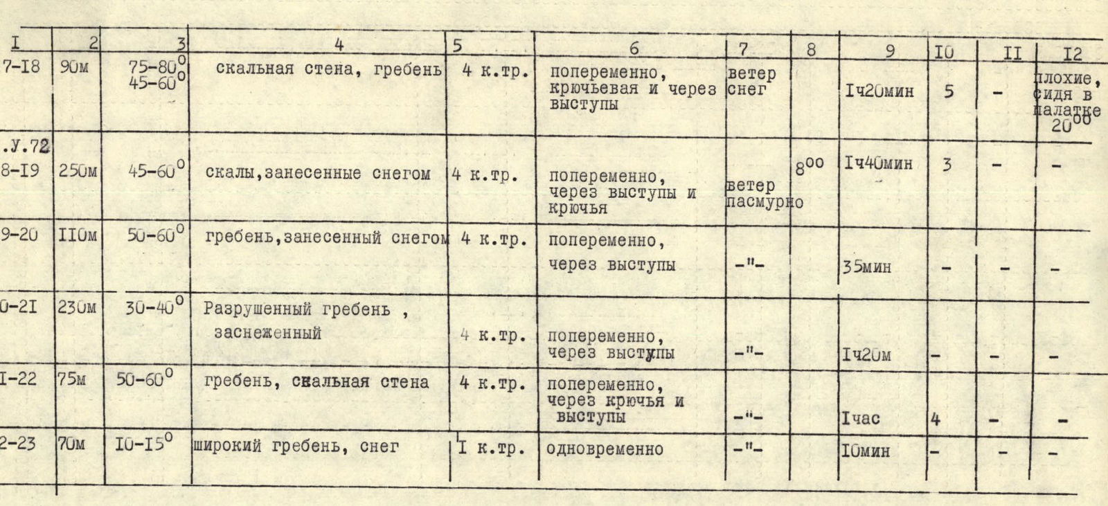
Table of Main Route Characteristics
| Section Days | Length | Steepness | Characteristics of sections and conditions of their passage by terrain character | by technical difficulty | by method of overcoming and protection | by weather conditions | Time of departure | Time of walking hours | Number of driven rock hooks | Number of driven ice hooks | Bivouac conditions |
|---|---|---|---|---|---|---|---|---|---|---|---|
| R0–R1 | 400 m | 40–45° | talus slope snow-covered | 1 cat. diff. | simultaneous, ice axe protection | cloudy −12° | 7:00 | 40 min | — | — | good, assault camp |
| R1–R2 | 300 m | 15–20° | ridge with rock outcrops, snow | 1 cat. diff. | simultaneous, placing rope around outcrops | — " — | 40 min | — | — | ||
| R2–R3 | 100 m | 40–50° | jagged rocks, snow | 3 cat. diff. | alternating, protection through outcrops | — " — | 25 m | — | — | ||
| R3–R4 | 150 m | 40–50° | jagged rocks, talus ledges, snow | 3 cat. diff. | alternating, protection through outcrops, hooks | wind, snow grains | 30 min | 3 | — | ||
| R4–R5 | 100 m | 40–50° | jagged rocks with snow | 3 cat. diff. | alternating, protection through outcrops | — " — | 25 m | — | — | ||
| R5–R6 | 130 m | 30–40° | rocky slope | 3 cat. diff. | alternating, protection through outcrops | — " — | 30 m | — | — | ||
| R6–R7 | 140 m | 45–50° | jagged rocks with snow | 3 cat. diff. | — " — | — " — | 40 m | 4 | — | ||
| R7–R8 | 80 m | 20° | wide ridge | 1 cat. diff. | simultaneous | wind, grains | 50 m | — | — | ||
| R8–R9 | 100 m | 50–55° | rocks and chute with snow | 4 cat. diff. | alternating, hook protection | wind, snow | 40 min | 5 | — | ||
| R9–R10 | 120 m | 20–30°, 50–60° | sharp ridge, slabs | 4 cat. diff. | alternating, hook and outcrop protection | — " — | 55 min | 4 | — | ||
| R10–R11 | 100 m | 20–30° | ridge, destroyed rocks | 3 cat. diff. | alternating, simultaneous through outcrops | — " — | 25 min | — | — | ||
| R11–R12 | 140 m | 35–40° | ridge | 4 cat. diff. | alternating through outcrops | — " — | 50 min | — | — | ||
| R12–R13 | 80 m | 10–15° | destroyed narrow ridge | 4 cat. diff. | alternating through outcrops | — " — | 30 min | — | — | ||
| R13–R14 | 60 m | 10–15° | very narrow ridge | 4 cat. diff. | alternating through outcrops and hooks | — " — | 45 min | 3 | — | ||
| R14–R15 | 150 m | 30–40° | ridge, destroyed rocks | 4 cat. diff. | alternating through outcrops | — " — | 50 min | — | — | ||
| R15–R16 | 110 m | 30–35° | ridge, destroyed rocks | 4 cat. diff. | alternating through outcrops | — " — | 40 min | — | — | ||
| R16–R17 | 90 m | 30–35°, 75–80° | very narrow ridge | 4 cat. diff. | alternating, through outcrops, hooks, rappel descent | — " — | 1 h 40 min | 8 | — | ||
| R17–R18 | 90 m | 75–80°, 45–60° | rocky wall, ridge | 4 cat. diff. | alternating, hook and outcrop protection | wind, snow | 1 h 20 min | 5 | — | poor, sitting in a tent | |
| R18–R19 | 250 m | 45–60° | rocks covered with snow | 4 cat. diff. | alternating, through outcrops and hooks | wind, cloudy | 8:00 | 1 h 40 min | 3 | — | — |
| R19–R20 | 110 m | 50–60° | ridge covered with snow | 4 cat. diff. | alternating, through outcrops | — " — | 35 min | — | — | — | |
| R20–R21 | 230 m | 30–40° | destroyed ridge, snow-covered | 4 cat. diff. | alternating, through outcrops | — " — | 1 h 20 min | — | — | ||
| R21–R22 | 75 m | 50–60° | ridge, rocky wall | 4 cat. diff. | alternating, through hooks and outcrops | — " — | 1 hour | 4 | — | — | |
| R22–R23 | 70 m | 10–15° | wide ridge, snow | 1 cat. diff. | simultaneous | — " — | 10 min | — | — | — |
The time taken to complete this route is 22 hours. A total of 32 rock hooks were driven.
Recommendations to Climbers
Group composition - no more than 6 people. Footwear - crampons-compatible boots. Tent and stove are mandatory. There are no good bivouac sites on the route. Hooks - rock type VTsSPS and long wedges.
In terms of its terrain, length, technical difficulty, and climatic conditions, the route along the Southwest Ridge of SOAN peak corresponds to a route of category 4A difficulty.
The composition of the first ascent group:
- POPOV V.N. 1st sports category, instructor, leader
- SHILONOSOV G.V. 1st sports category
- SHULGINA L.A. 1st sports category, instructor
- SHILONOSOVA T.A. 1st sports category
View of section R16–R17 from an elevation on the ridge pos. 16. Photo 5.
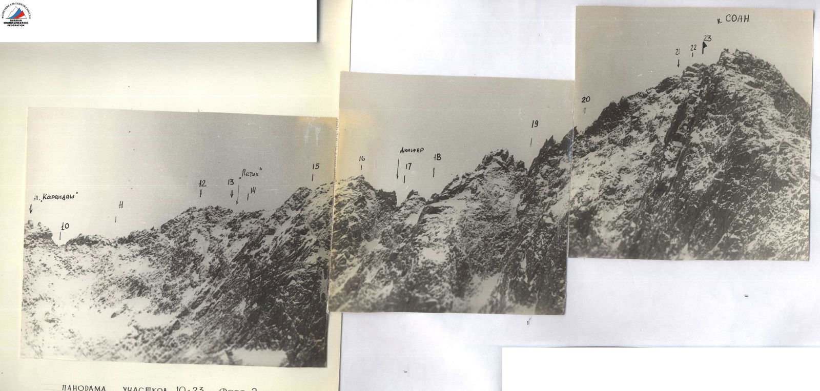
Panorama of sections R10–R23. Photo 2.