Route via the South-East Ridge (approximately 3A category of difficulty)
The summit of SOAN (Siberian Branch of the Academy of Sciences) is located in the main ridge of the Tunka Alps — East Sayan. The Tunka Alps are stretched by a single ridge with spurs from west to east between the rivers Irkut and Kitoy. The summit itself is slightly protruding to the south along a spur sandwiched between the Zun-Khandagai and Talta rivers. To reach the base camp of the route via the South-East ridge, one needs to follow the Zun-Khandagai river valley.
From November to mid-May, the rivers of the Sayan are frozen, and the valleys have shallow loose snow. By May, some open snowfields become firn, but the snow generally retains its looseness until it melts. Ice fields and aufeis can be found along the river valleys and persist until mid-July. Numerous high-altitude lakes are completely ice-free by the second half of July. There is no glaciation in the summit area.
The most favorable time for climbing:
- June
- July
- Early August
TRANSPORTATION
From Irkutsk, take a scheduled bus or a car to the Arshan resort — 218 km. From the Arshan resort to the Zun-Khandagai river valley (west along the mountain ridge) by car or on foot — 12 km. Up the Zun-Khandagai river valley on foot to the fork of the Left and Right Zun-Khandagai — 9 km.
At the fork, it is convenient to set up a base camp, as it is located at the forest boundary. The river valley is narrow, with slopes heavily overgrown with forest and bushes. A faint trail runs along the valley, and it is recommended to inquire about its location with climbers from Irkutsk.
GROUP COMPOSITION:
- Leader — Abalakov O. V., Master of Sports
- Razmakhnin M. V., 2nd sports category
- Belousov V. V., 2nd sports category
-
- 4A, 4A, 4B
- Voskresenskaya D. V., 2nd sports category
| Days | Route Section | Overnight Location | Notes |
|---|---|---|---|
| August 7, 1969 | Base camp — assault camp | Assault camp | |
| August 8, 1969 | Assault camp — South-East ridge — assault camp | Assault camp | |
| August 9, 1969 | Assault camp — base camp | Base camp |
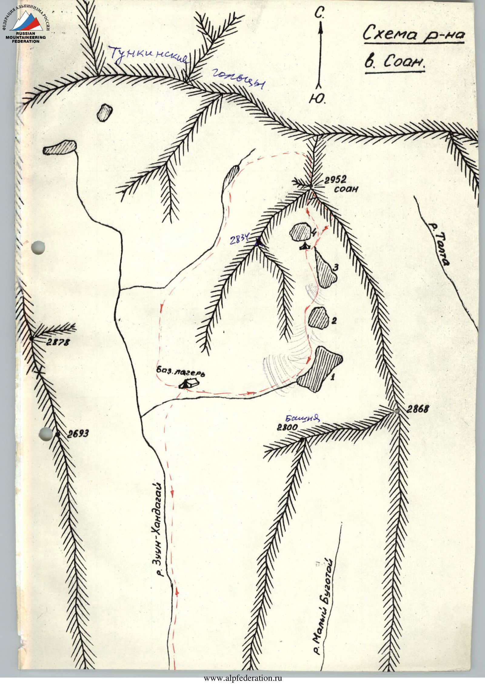
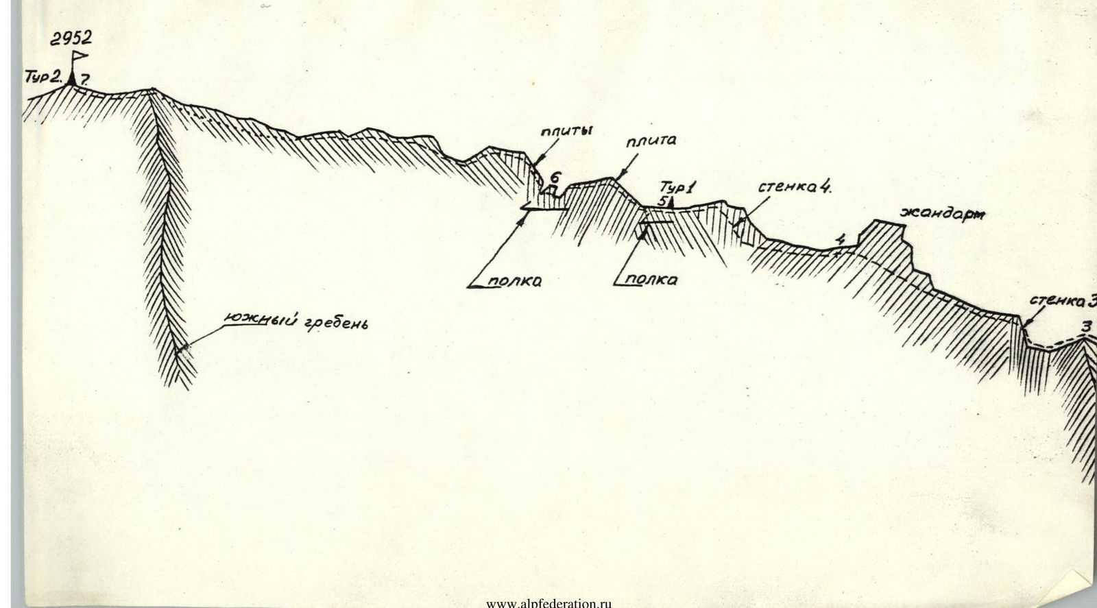
Scheme
Scheme of the SOAN summit area
Route Description
Via the South-East Ridge of SOAN summit (2952 m)
(Approximate category of difficulty 3A) Time: August, no snow. Geographical location: Sayan, Tunka Mountains. The summit is located near the source of the Left Zun-Khandagai river.
From the Arshan settlement:
- 12 km west to the Zun-Khandagai river valley.
- Up the valley to the base camp at the forest boundary (confluence of the Left and Right Zun-Khandagai) — 9 km.
- Elevation — 1890 m.
The assault camp is located directly under the route between the Soan and the 2nd lake (2500 m).
Section R1–R2
From the assault camp, the route goes along a large scree to the right onto the South-East ridge. Along the gentle ridge, keeping to the left side, the route reaches a gap that drops off (200 m) into the right valley. The gap is bypassed slightly to the left along a narrow isthmus, from which the ridge sharply increases its slope to 40°. From this point on, the route follows exactly along the ridge, enclosed by the South and East walls of the summit. 80 m from the gap, a heavily destroyed wall is encountered, consisting of huge boulders. The wall is bypassed by easy climbing to the left, and the route returns directly to the ridge. On the wall section, the belay is alternate through ledges. For the rest of the section, the belay is simultaneous.
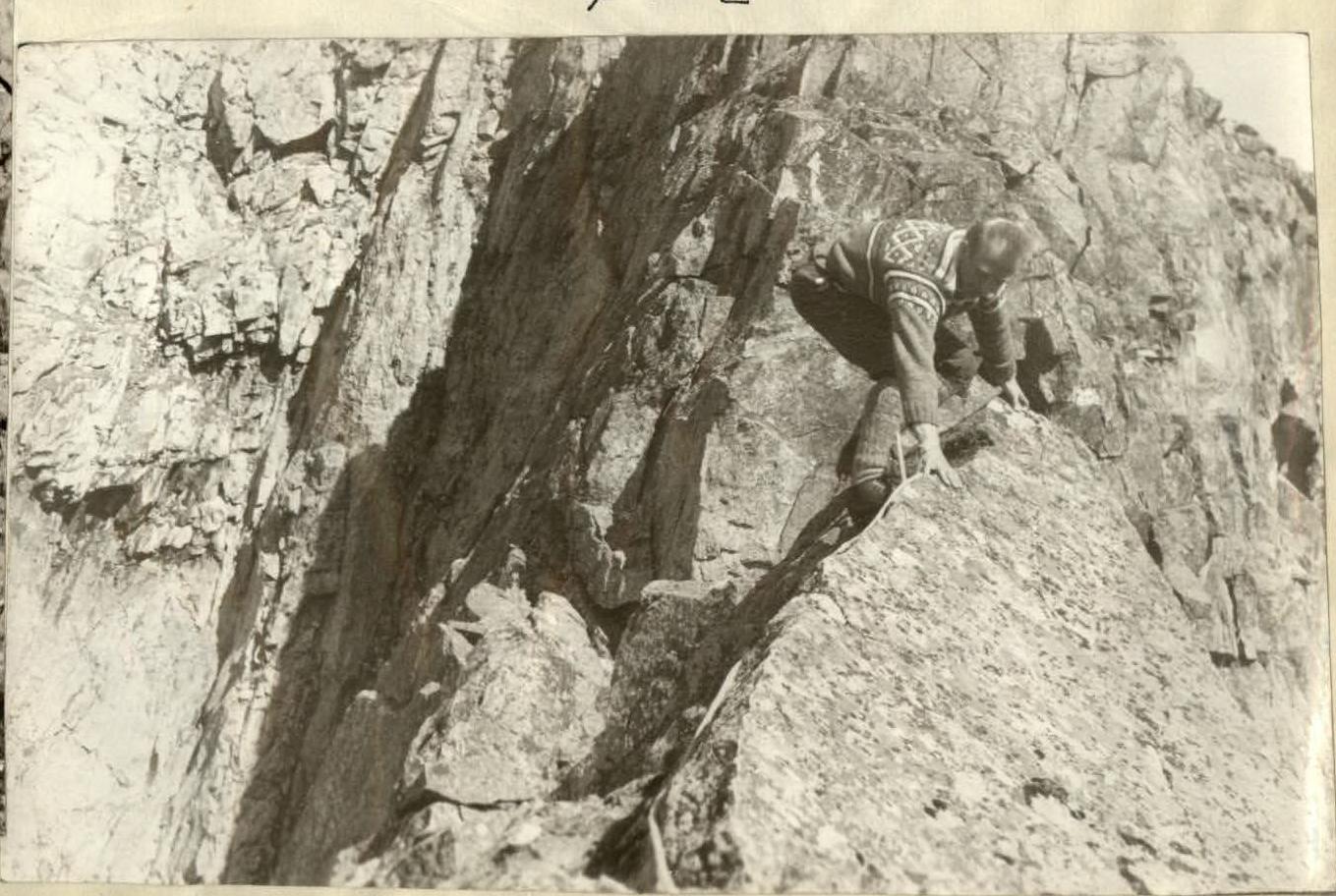
After the wall, the route follows along the ridge composed of large boulders, alternating with monoliths. For 120 m, the slope is 40°. At the end of the section, the route reaches a sharp horizontal ridge-knife (photo 2) 10–12 m long. The ridge ends in a gap. The width of the isthmus is 0.5 m. The length of the isthmus before the wall is 1.5 m.
Belay on the knife-edge is alternate through ledges.
Section R2–R3
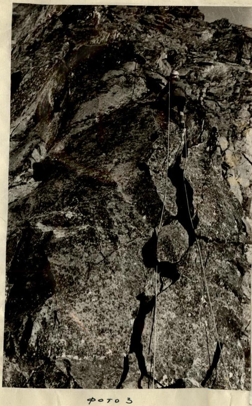
In the gap, belay can be organized through a boulder that has shifted away from wall 1, 1.5–2.0 m high.
From the gap, the route goes directly at wall 1 via a cleft (photo 3). The first 10–12 m have a slope of 70°. At the top of the cleft, a belay anchor is fixed. Further, 7–8 m along easy rocks with a slope of 50° lead to a vertical monolithic stone 2 m high. The monolith is overcome by easy climbing; the width of the monolith is up to 1.0 m.
Along a 1.5 m sheer drop, the route reaches slabs with a limited number of holds. Further, the ridge expands sharply (10–12 m). The angle of the slabs is 30°.
Behind the slabs, the ridge consists of boulders and monoliths with numerous ledges. 30 m from the slabs, a wide shelf is encountered, sloping to the right (a site can be set up), followed immediately by a double wall 2. Initially, the height is 2 m, then a shelf, and again a wall 3 m of moderate difficulty. At the top, there is a slightly sloping rock platform 5 × 7 m.
Here, a small ridge approaches from the left, along which the southern wall route emerges. Belay is simultaneous, and in places alternate.
Under the rock platform, there is a good shelf, convenient for an overnight stay.
Section R3–R4
From the rock platform (the junction of the wall route ridge with the South-East ridge), the route goes into a small gap with a ridge width of 15 m. To the left and right, there are sheer drops.
From the gap, it is necessary to go directly at wall 3, 4 m high. Climbing is of moderate difficulty.
Further, behind the wall, the route follows along the ridge, consisting of monoliths and boulders. Belay is alternate. The visible small gendarme in the form of a summit (see photo 1) is bypassed to the left along easy rocks, then back onto the ridge, which is somewhat widened in the form of sloping platforms.
Section R4–R5
Wall 4.

The wide ridge ends in an ascent (see drawing), with difficult climbing directly at wall 4 — to the left at 65° and sheer to the right with ledges. It is overcome by climbing of moderate difficulty to the left along the wall. Initially, it traverses (about 10 m), and then goes up to the ridge. The few holds are firm. Belay is alternate with pitons.
After the wall, there is a narrow horizontal ridge. On the ridge itself, there is Cairn 1. The ridge is monolithic, with no ledges. Belay is with pitons along the sharp ridge.
Section R5–R6
The narrow ridge without ledges expands slightly after 12–15 m, and the shelf becomes more rugged.
Here, a narrow cleft is encountered directly on the ridge. It is necessary to:
- climb up 3 m;
- move along the right boulder.
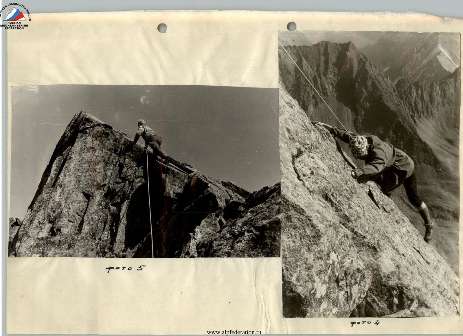
Further, the ridge is again heavily rugged and consists of large blocks. 40 m from the cleft, there is an ascent along a flat slab at an angle of 40° (Photo 4) 12 m long. Easy climbing. The slab is monolithic. The ledges are firm. Belay is alternate through ledges. After the ascent, along the rugged ridge composed of boulders, to a small platform. (On section R5–R6, there are several platforms suitable for semi-reclining overnight stays.)
Section R6–R7
The platform leads to a wall, the exit to which is to the right, and then the route follows along the sharp ridge to an ascent (photo 5); keeping to the right side of the ascent. The steepness of the right side of the ascent plane is 80°. The section is overcome with alternate belay.
Further, the route follows directly along the ridge, heavily rugged with small ascents. The ridge is not wide. Throughout the route, the width of the ridge varies from sharp to 10–12 m, and then drops off with walls. Belay on the remaining part of the ridge is simultaneous.
60 m from the summit, the ridge expands and turns into a wide large scree. The summit is gentle, consisting of large and medium-sized stones.
Descent is along the ascent route or along the north ridge into the Right Zun-Khandagai valley. In this case, to reach the assault camp, it is necessary to go around the entire massif of the summit — 7 hours.
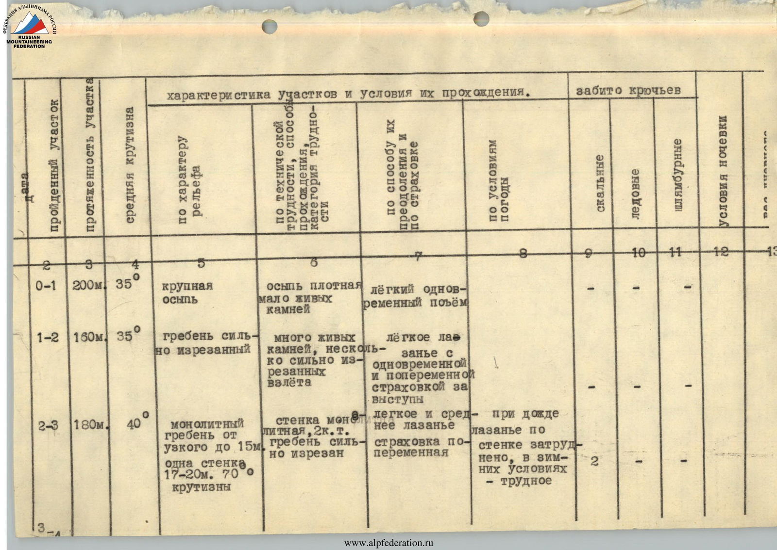
| Covered Section | Length of Section | Average Steepness | By Relief Characteristics | By Technical Difficulty, Method of Passage, Category of Difficulty | By Method of Overcoming and Belaying | By Weather Conditions | Pitons Driven (Rock) | Pitons Driven (Ice) | Pitons Driven (Bolts) | Overnight Conditions | |
|---|---|---|---|---|---|---|---|---|---|---|---|
| R0–R1 | 200 m | 35° | large scree | dense scree, few loose rocks | easy simultaneous ascent | - | - | - | |||
| R1–R2 | 160 m | 35° | heavily rugged ridge | many loose rocks, several heavily rugged ascents | easy climbing with simultaneous and alternate belay through ledges | - | - | - | |||
| R2–R3 | 180 m | 40° | monolithic ridge from narrow to 15 m, one wall 17–20 m, 70° steep | monolithic wall, 2, heavily rugged ridge | easy and moderate climbing, alternate belay | in rain, climbing the wall is difficult; in winter — difficult | 2 | - | - | ||
| R3–R4 | 80 m | 20° | narrow monolithic ridge | rocks with numerous holds, several walls 2 | easy climbing with alternate belay through ledges | in winter, climbing is difficult | - | - | - | ||
| R4–R5 | 60 m | 20° | narrow monolithic ridge | rocks rugged, wall with limited holds 2 | easy and moderate climbing with piton belay through ledges | "" | 2 | - | - | ||
| R5–R6 | 40 m | 15° | narrow monolithic ridge with shelves | rocks heavily rugged, easy | easy climbing with piton belay and through ledges | 2 | - | - | |||
| R6–R7 | 180 m | 10° | narrow monolithic ridge, expanding near the summit | easy rocks | easy climbing with simultaneous belay | - | - | - |