Route Description
via the south-eastern ridge of Mt. SOAN (2952 m) in winter. Ascent date: May 5–6.
From the base camp (1800 m), located at the fork of the Zuun-Khandagai River on the forest border, the group needs to move up to the southern wall of Mt. SOAN to set up an assault camp. See the diagram. The path goes up along the left stream (orographically) past large high-altitude lakes.
The lakes are separated by powerful ascents consisting of:
– large stones, – boulders, – rocks.
Movement is hampered by depressions between boulders filled with snow. The path across the lakes goes directly across the ice and packed snow. The ascents are steep, and one has to gradually gain altitude, reversing along the slope. The ascent to the first lake, which resembles a flattened animal skin, provides a 350 m elevation gain.
The ascent from the first lake to the second rises by 250 m, and the seemingly small peak behind the lake is recommended to be bypassed on the left side in the direction of travel.
From the second lake, there is a 100 m ascent consisting of rock fragments and a rocky slope.
The third lake resembles an elongated droplet from above, and when reaching this ascent, the view of Mt. SOAN opens up. See photo 1.
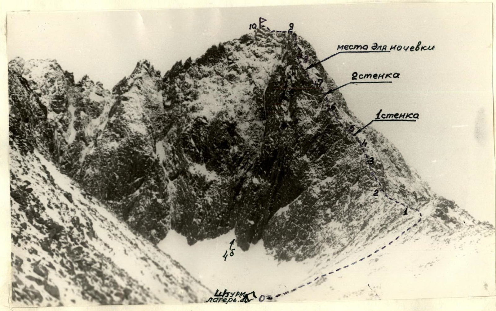
Next, it is necessary to traverse the frozen lake and set up an assault camp between the third and fourth lakes among large boulders. The ascent between the third and last – fourth lake does not exceed 10 m.
The journey from the base camp to the assault camp takes 3.5–4 hours.
Section R0–R1
From the assault camp, the route goes along a steep talus slope filled with snow to the right onto the south-eastern ridge. Along the gentle ridge, sticking to the left gentle side, the route reaches a small dip that drops into the neighboring valley of the Talta River with a vertical wall. The dip is traversed along a narrow isthmus, from which the south-eastern ridge sharply increases its slope to 40–45°. From this point, the route goes exactly along the ridge formed by the junction of the Southern wall and the Eastern.
Section R1–R2
From the dip, the route goes along the ridge, 10–15 m wide, representing a snowy rocky slope with unclear small grooves filled with snow.
The path is traversed simultaneously with kicking or treading steps in the snow (depending on the snow condition). Rockfall onto the group is excluded along the entire route length, as rocks fall to the left or right along the wall.
Section R2–R3
At a distance of two ropes from the dip, the first wall is encountered, consisting of heavily dissected boulders. The wall is passed slightly to the left with easy climbing. Insurance is organized through rock outcrops, which are numerous in this area, and the section is traversed alternately. Some difficulty in passing this section is caused by snowy boulders, which are hard to grasp, and the micro-relief is limited. For this, a strict set of gloves and mittens should be considered.
Section R3–R4
After the heavily dissected rocks, the ridge somewhat flattens and represents a wide (up to 15 m) slope of large boulders and rocky monoliths. All this is covered with snow with cornices over the wall.
The section is traversed in the center of the ridge simultaneously. Steps are kicked. The section is 120 m long with a ridge slope of 40°. At the end of the section, a 3 m wall appears, passed with easy climbing and assistance.
Section R4–R5
Presents the first technical difficulty. Initially, the route leads to a sharp horizontal ridge – a "knife edge" 12 m long, ending in a small depression. In the depression, the ridge width reaches 0.5 m. The sharp "knife edge" is traversed on top or along one side in counter-pressure. Insurance is alternating through rock outcrops.
In the depression, insurance is well-organized through a boulder slightly lagging behind wall No. 1. See Fig. 1.
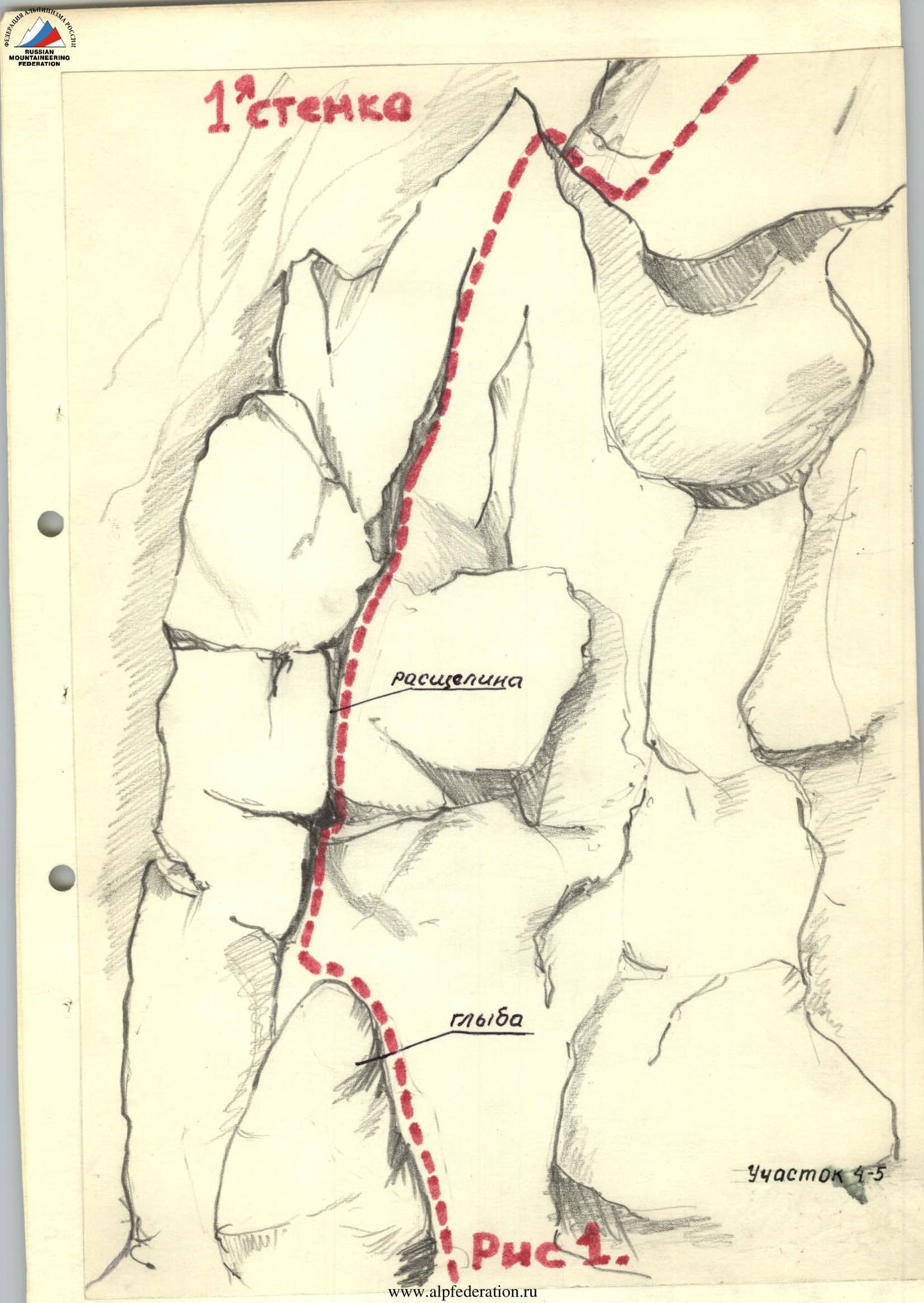
Further, the route goes straight into the wall (See Fig. 1) along a crevice. The first 10–12 m have a steepness of 70°. The crevice is filled with ice. Climbing is difficult with piton insurance. Holds have to be cleared of snow and ice. Ice pitons and long rock pitons fit well into the cracks.
Further, 8 m along medium rocks under a slightly overhanging stone, bypassing it on the right, the route leads to the top of wall No. 1.
Section R5–R6
From the top of wall No. 1, it is necessary to descend vertically down by 1.5 m. Further, the ridge widens and consists of inclined slabs with a limited number of holds.
When passing the slabs, it is necessary to:
– kick steps; – use thorough alternating insurance.
On the slabs themselves, 1 piton is driven; otherwise, insurance is through outcrops and ice axe.
Behind the slabs, the ridge consists of flat boulders dissected by cracks and with a large number of holds. 30 m from the flat slabs, there is a small shelf, slightly inclined to the right, where a tent can be set up.
Section R6–R7
Immediately from the site, wall No. 2 of a stepped character appears. Initially, a 2.5 m vertical section is overcome, then a shelf follows, and another 3.5 m wall is taken head-on. See photo 2. At the top, there is a slightly inclined 5 × 6 m site.
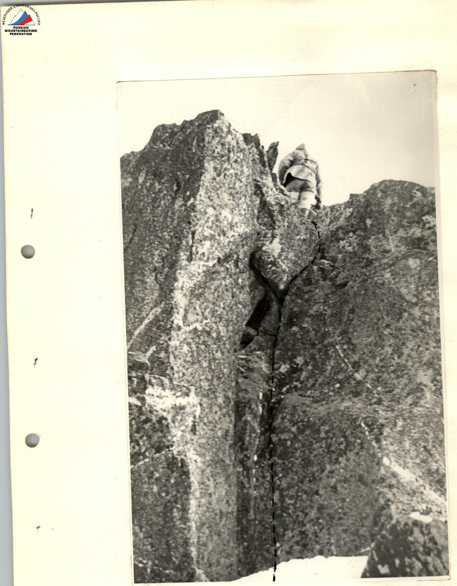
At this point, a small ridge approaches from the side of the Southern wall, along which the southern wall route 4Б category of difficulty emerges. Insurance is alternating through pitons and outcrops. Rocks have an unpleasant ice crust on the southern side, covered with snow. Constantly, it is necessary to:
– sweep outcrops from snow; – chip off the ice crust to create a reliable support.
The possibility of deviating from the route or exiting onto another route is excluded, as the ridge is bounded on both sides by vertical walls along its entire length.
Section R7–R8
After the junction of the South-Eastern ridge and the short Southern ridge, the entire further route passes along a narrow, sharp ridge, characteristic of most ridges of the Eastern Sayan peaks. See photo 3.
The ridge on this section:
– is heavily dissected into boulders; – has many holds and protruding stones for organizing insurance; – is traversed easily with the organization of simultaneous and alternating insurance.
It is characteristic of Sayan routes that on such ridges, there is very little snow, and snow cornices are generally rare. Snow lies only on shelves, in crevices, and cracks.
If necessary, on section R7–R8, a site for a tent can be arranged.
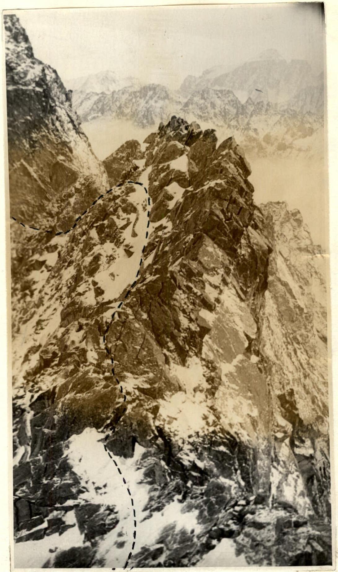
Section R8–R9
After 4 ropes, the heavily dissected ridge turns into a monolithic one with small ascents and descents. The elevation gain is small. See Fig. 2. Climbing becomes of medium and increased difficulty. There are few outcrops and holds. Often, one has to go in counter-pressure, holding onto the top of the ridge. Ice axes are not needed on this section. Directly on the ridge is cairn No. 1. Traverse directly through it. Rocks are cold, often with sections covered with ice crust, and movement is hampered in mittens. Insurance throughout the section is alternating through pitons and rare outcrops. Cracks are mainly filled with ice; wide ones are filled with snow.
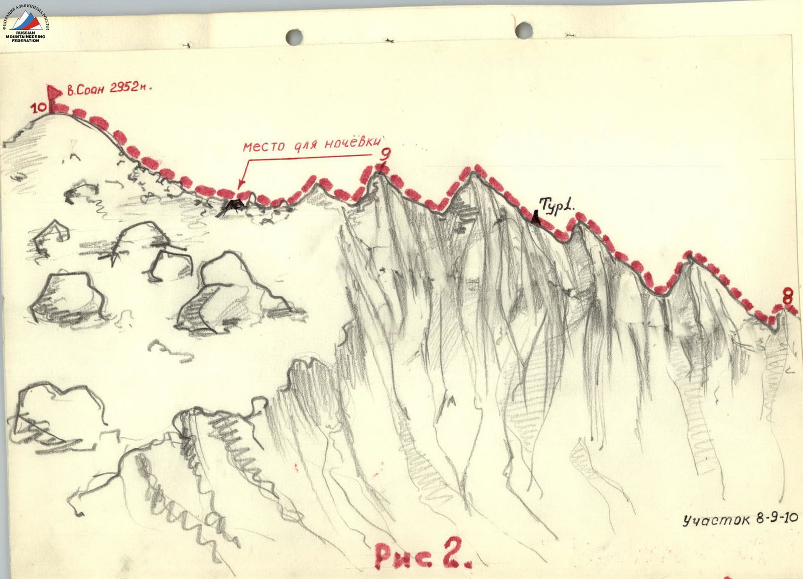
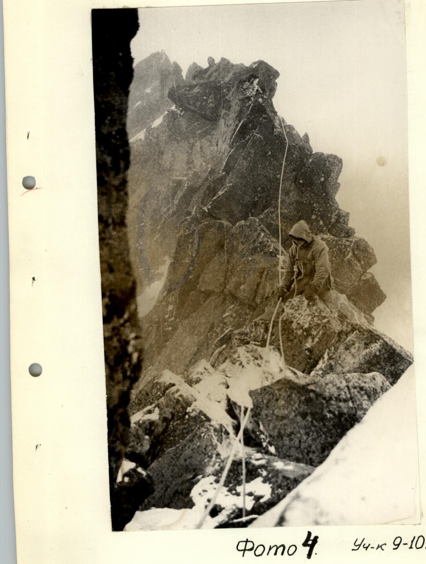
Section R9–R10
After the last small gendarme of section R8–R9, the ridge flattens. Initially, it also consists of large boulders and outcrops (See photo 4), and then gradually widens and turns into a pre-summit plateau covered with snow. Here is a convenient place for a bivouac, but there is no shelter from the wind. To the summit, the path goes simultaneously with a small elevation gain and kicking steps.
The summit is a large, gentle dome: in summer covered with large stones, in winter filled with snow. Here is a high cairn No. 2.
From the summit, you can descend via two routes:
- along the ascent path.
- Along route 1Б category of difficulty along the northern ridge, but in this case, the group will end up in the right valley of the Zuun-Khandagai River, from where it is convenient to go only to the base camp at the fork of the valley. See the map.
The group descended along the ascent path, organizing a night stay at the beginning of the ridge. See Fig. 2.
The entire route from the assault camp to the summit took 16 hours.
Driven pitons – 21 rock, 2 ice.
Recommendations for Climbers
The group size should not exceed 6 people. Recommended footwear – rigid boots. For a sports group, it is advisable to bring:
– a tent; – a primus stove.
For a training group, it is mandatory to plan an overnight stay on the route. Have several spare pairs of gloves and warm mittens. Bring:
– ice pitons type VTsSPS or long wedges; – rock pitons of usual sizes and shapes.
In terms of its relief, length, technical difficulty, and climatological features of the area, the route along the south-eastern ridge of Mt. SOAN in winter corresponds to category of difficulty 3Б.
Table of Main Route Characteristics by Sections
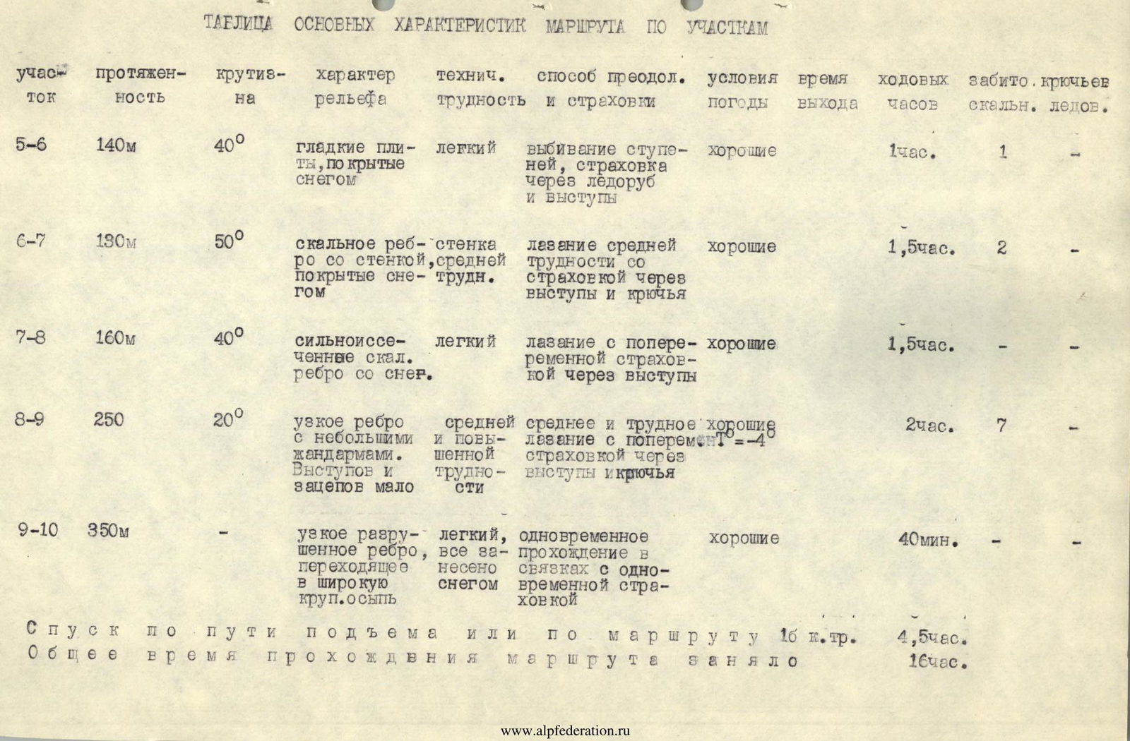
| Section | Length | Steepness | Relief Character | Technical Difficulty | Method of Overcoming and Insurance | Weather Conditions | Temperature | Time Taken | Pitons Driven (rock / ice) |
|---|---|---|---|---|---|---|---|---|---|
| R0–R1 | 350 m | 35° | Large talus slope with rock outcrops, snow-covered | Easy | Simultaneous passage with self-insurance via ice axe | Good | T –12 °C | 30 min | – / – |
| R1–R2 | 60 m | 45° | Snowy rocky slope | Easy | Passage in rope teams with step-kicking and self-insurance via ice axe | Good | 20 min | – / – | |
| R2–R3 | 80 m | 45° | Heavily dissected rocks | Easy and medium difficulty, snowy | Climbing with insurance via outcrops | Good | 1 h | – / – | |
| R3–R4 | 120 m | 40° | Wide rocky ridge | Easy | Simultaneous passage in rope teams | Good | 1 h | – / – | |
| R4–R5 | 120 m | 45° | Sharp rocky ridge ending in a wall. Ice accretions | Difficult wall | Difficult climbing with piton insurance | Good | T –10 °C | 2 h | 8 / 2 |
| R5–R6 | 140 m | 40° | Smooth slabs covered with snow | Easy | Step-kicking, insurance via ice axe and outcrops | Good | 1 h | 1 / – | |
| R6–R7 | 130 m | 50° | Rocky ridge with a wall, snow-covered | Wall of medium category of difficulty | Climbing of medium difficulty with insurance via outcrops and pitons | Good | 1 h 30 min | 2 / – | |
| R7–R8 | 160 m | 40° | Heavily dissected rocks. Ridge with snow. | Easy | Climbing with alternating insurance via outcrops | Good | 1 h 30 min | – / – | |
| R8–R9 | 250 m | 20° | Narrow ridge with small gendarmes. Few outcrops and holds | Medium and increased category of difficulty | Medium and difficult climbing with alternating insurance via outcrops and pitons | Good | T –4 °C | 2 h | 7 / – |
| R9–R10 | 350 m | – | Narrow destroyed ridge, all snow-covered, turning into a wide talus | Easy, simultaneous passage in rope teams with simultaneous insurance | Good | 40 min | – / – |
Descent along the ascent path or along route 1Б category of difficulty – 4 h 30 min. The total time taken for the route was 16 h.