Йцукенгшщзхъфывапролджэяч
Смитьбюйцукенгшщзхъфывап
Ывапролджэячсмитьбюйцукен
Covering letter. Hello, respected members of the classification commission! The leader of this ascent, B.A. Khandazhapov, is addressing you.
As part of the FASIO training camp held in the Sayan Mountains from November 1 to 9, 2014, we completed this ascent. After a meeting of the coaching council consisting of:
- S.A. Kirillov — senior coach,
- S.V. Kosoturov — training officer,
- B.A. Khandazhapov — instructor, 3rd category,
it was decided to petition the FAR classification commission to raise the category of difficulty of this route to 3A. Under my leadership, the participants compiled a report. I ask you to familiarize yourselves with it and make a decision. Sincerely, B.A. Khandazhapov.
Passport
- Class: rock
- Region: Eastern Sayan, Barun-Khandagai valley.
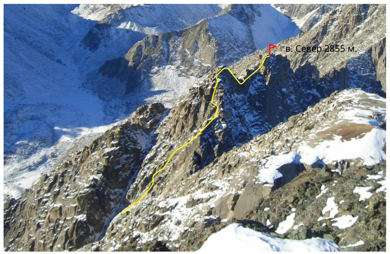
- Peak: Sever, height 2855 m, via the eastern ridge
- Proposed — 3A category of difficulty, repeat ascent
- Height difference 480 m, length — 750 m, length of sections — 1st category of difficulty — 430 m, 2nd category of difficulty — 185 m, 3rd category of difficulty — 35 m, 4th category of difficulty — 100 m, average steepness of the main part of the route — 50°.
- Pitons hammered: rock — 0/0, chocks — 17/0.
- Team's walking hours — 13 hours.
- No overnight stays.
- Leader: B.A. Khandazhapov — Master of Sports.
Participants:
- D.S. Generalchenko — 2nd sports category
- D.S. Orlov — 3rd sports category
- Date of departure and return November 4, 2014.
- Organization: Federation of Alpinism and Rock Climbing of Irkutsk Region.
Brief Overview of the Ascent Region
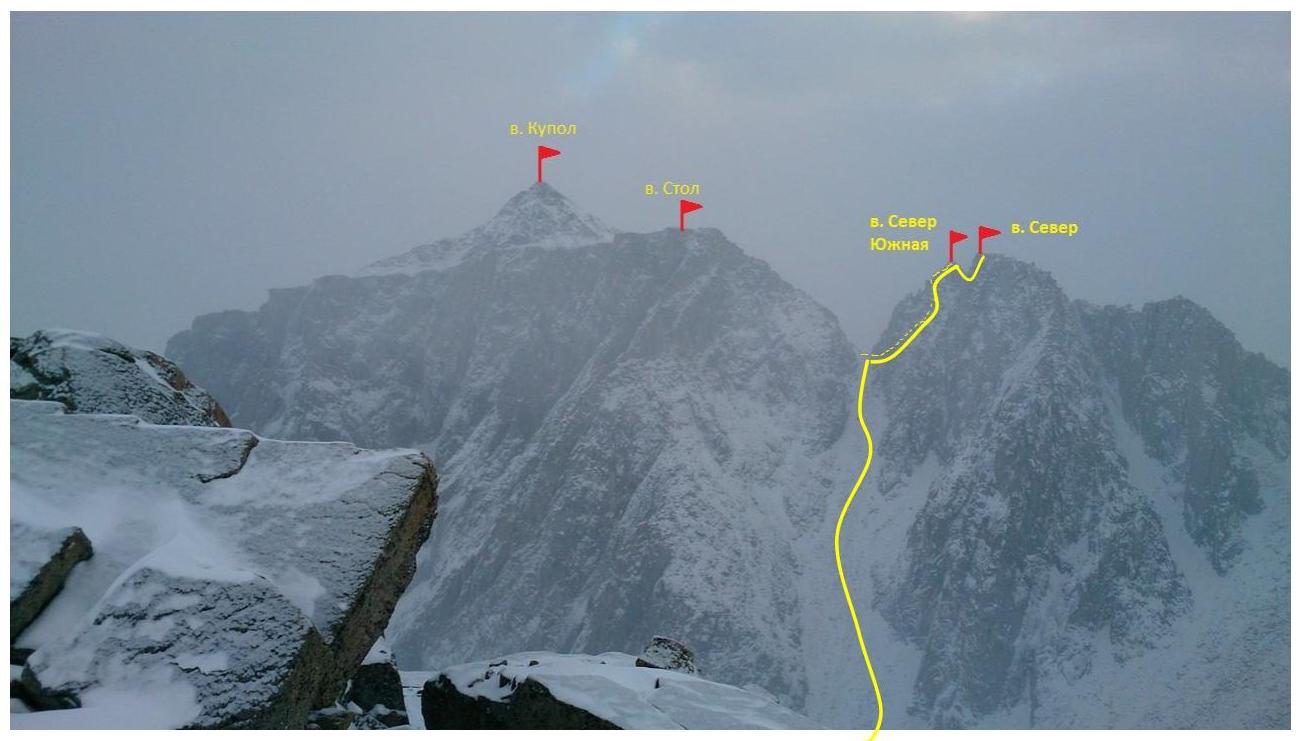
The peak Sever is located in the southern spur of the Tunkin Goltsy ridge, between the Tunka and Barun-Khandagai valleys, near the peak Stol.
The initial development of the Barun-Khandagai valley began in the 1970s and originated from the neighboring Zun-Khandagai valley. Routes were laid on peak Neftekhimik — 5A category of difficulty, Barun — 5B category of difficulty. By the early 1990s, a stationary camp of 4 houses was built in the tundra zone, of which only one remained.
One can reach the Barun-Khandagai valley from Irkutsk. The journey initially takes 4–5 hours by car to the settlement of Arshan, then 15 km (through the village of Tagarkhay) to the Lesnichikha clearing. Then from the Lesnichikha clearing to the entrance of the Barun-Khandagai valley. Further along the river on a trail to the abandoned zimovye — 5–6 hours.
From the base camp, head left upwards along the steep moraine into the cirque formed by peaks Kupol, Stol, and Neftekhimikov, to the couloir leading to the start of the route — 1.5–2 hours.
Exit from the base camp located on the forest boundary — 7:00. Ascend up the river from the base camp, left upwards along the right "counterfort" of the steep moraine into the cirque formed by peaks Kupol, Stol, and Neftekhimikov. (1 hour).
Then move to the end of the valley along the slopes of peak Stol to the start of the couloir separating peak Stol and peak Sever at the top. The 2A category of difficulty route to peak Stol follows this couloir. Peak Sever is opposite peak Monakh and closes the left row (by direction of travel) of peaks.
From the start of the "cushion" of the moraine to the required couloir — 1–1.5 hours. Route description
R0–R1, 350 m, 45°, I category of difficulty — move up the couloir to the col, snow-firn and large rock rubble in the couloir.
R1–R2, 80 m, 45°, I category of difficulty — from the col, go around the first pillar on the right (10 m, 40°, I category of difficulty) upwards and then descend downwards.
R2–R3, 15 m, 70°, IV category of difficulty — here begins the main part of the route. Direction towards the right shoulder of the ridge bastion of the peak.
Sections:
- R2–R3
- R3–R4
R3–R4, 35 m, 60°, III category of difficulty — move upwards, veering slightly left.
R4–R5, 45 m, 45°, II category of difficulty — the third rope goes right-upwards along the rocks of IV–V category of difficulty, in the direction of the shoulder of the ridge.
Section R4–R5 Section R5
R5, R5–R6, 35 m, 70, IV category of difficulty — then an internal corner leads to the ridge, follow it.
Section R5–R6
R6–R7, 50 m, 70, IV category of difficulty — then pass left of the ridge and up a slanting wide crack.
Section R6–R7 Section R6–R7, R7–R8, 40 m, 60, II category of difficulty — then move along the ridge and exit to the southern subpeak of Sever.
R8–R9, 100 m, 45, II category of difficulty. Traverse along the ridge with a descent to the col between the peaks and ascent to the main peak Sever.
From the start of the couloir to the peak, the ascent takes 5–6 hours.
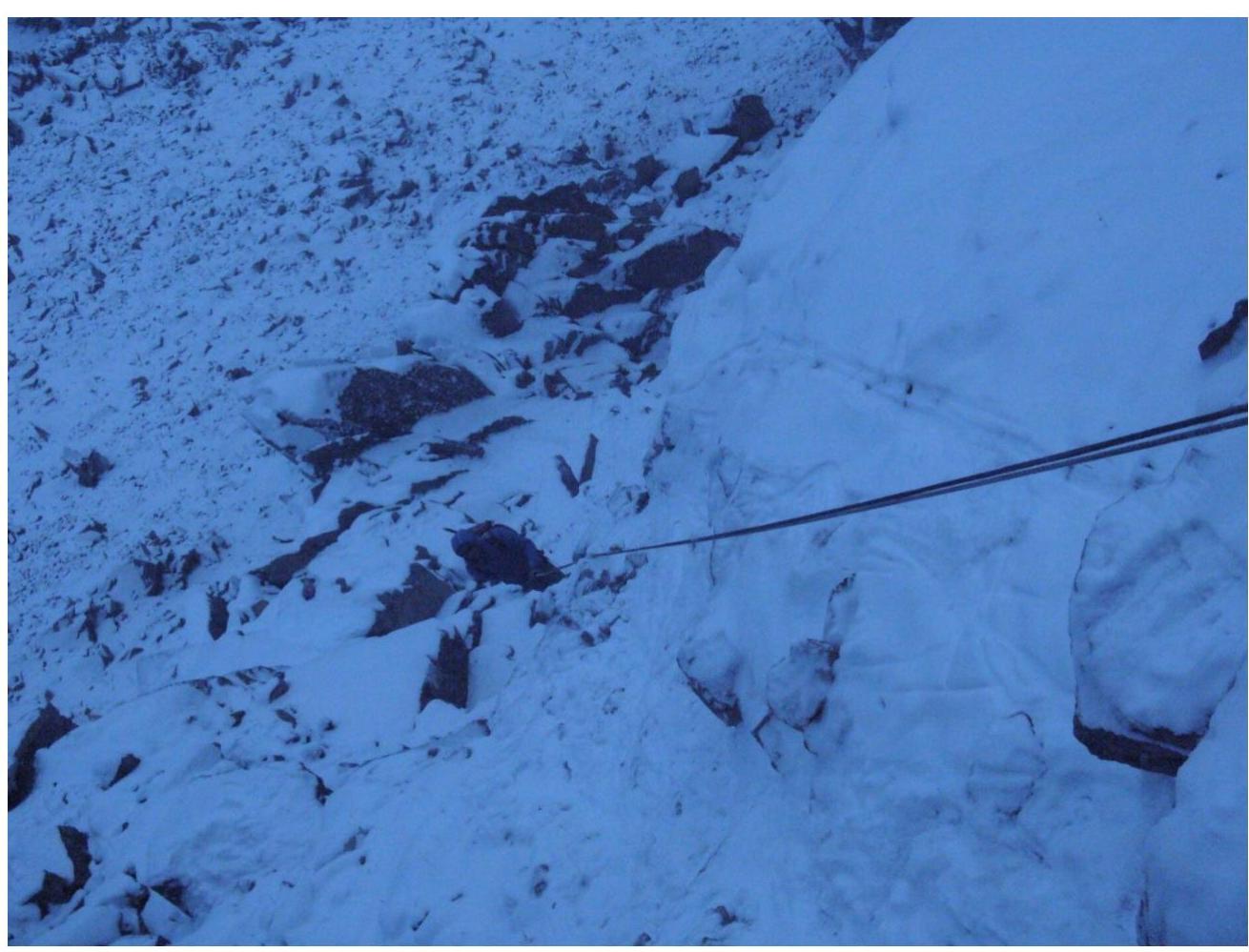
Descent. The descent is made via the ascent route. Return to the first peak, directly below it is a convenient place to organize a rappel. Go down on a full rope (50 m) to section R5. Then on foot downwards, veering slightly right, along the loose rocks to the second rappel. Then another 50 m down, veering slightly left. Then the third rappel (20 m) leads to the start of the route. Return along our tracks through the couloir and turn right, proceed to the col between peak Stol and peak Sever and then down the couloir.
Second "rappel" UIAA scheme on peak Sever via the Eastern ridge, 3A category of difficulty
| | Section | Length (m) | Category of difficulty | Steepness | Chocks | Rock protection | | | :--: | :--: | :--: | :--: | :--: | :--: | :--: | :--: | | | | | 750 | | | | | | | | R6–R9 | 100 | 2 | 45° | 0 | | | | | R7–R8 | 40 | 2 | 60° | 0 | | | | | R6–R7 | 50 | 4 | 70° | 5 | | | | | R5–R6 | 35 | 4 | 70° | 4 | | | | | R4–R5 | 45 | 2 | 45° | 2 | | | | | R3–R4 | 35 | 3 | 60° | 2 | | | | | R2–R3 | 15 | 4 | 70° | 4 | | | | | R1–R2 | 80 | 1 | 45° | 0 | | | | | R0–R1 | 350 | 1 | 45° | 0 | 0 |
General photo of the peak
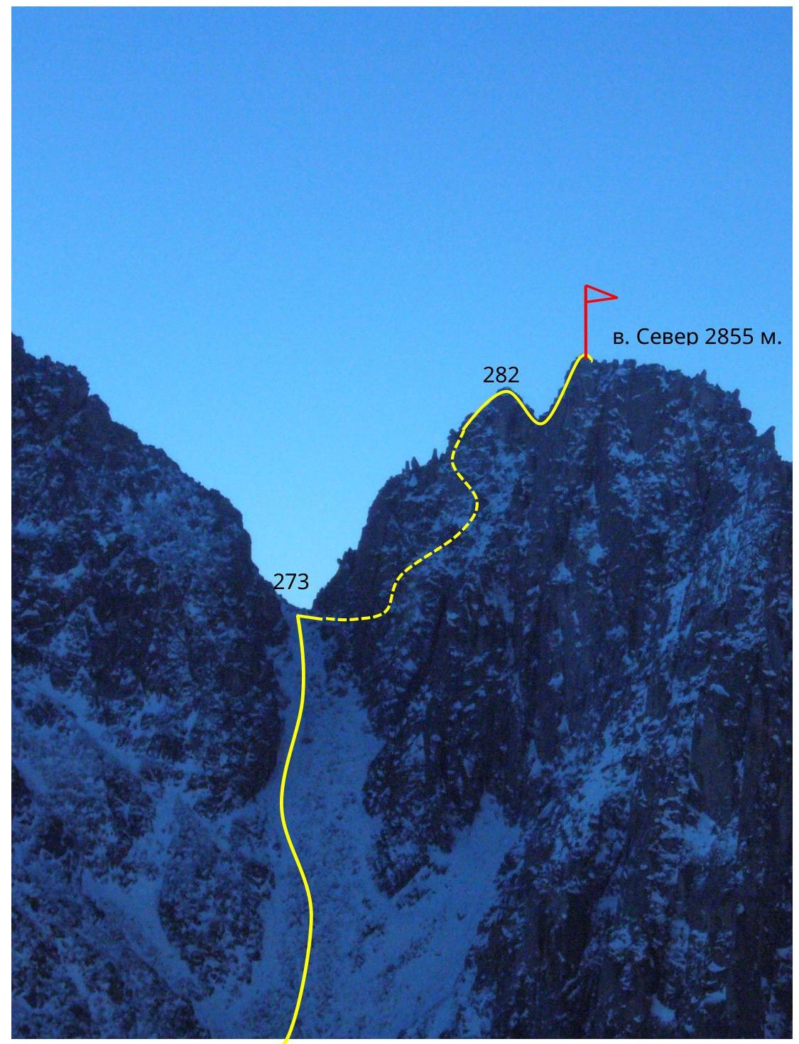
General profile of the route
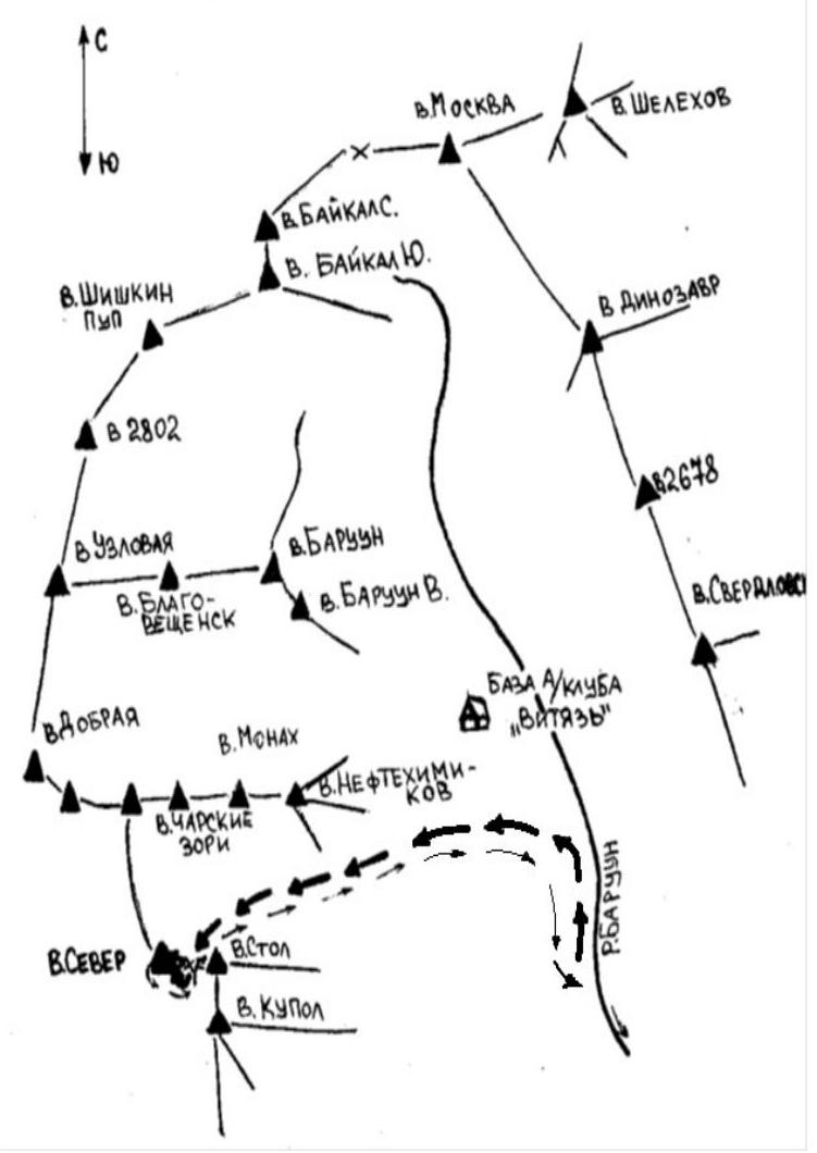
Panorama of the region
Scheme of the Babysy — Hangard area