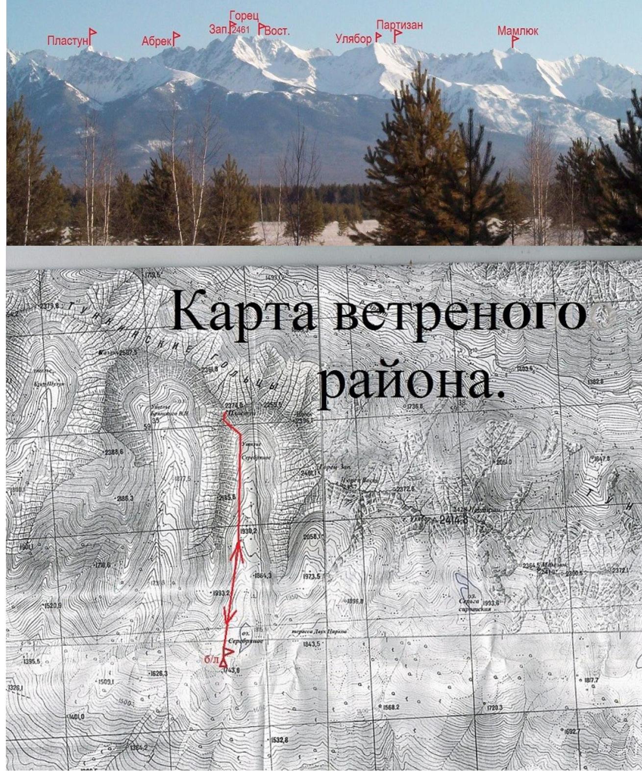
Ascent record for Mt. Plastun (2374 m) via the Southeast wall, rated 3B category.
- Eastern Sayan, Tunkinskie Goltsy ridge, Serebryanoe valley (Vetryany region), section 6.1.2.
- Mt. Plastun (2374 m) via the Southeast wall.
- Rated 3B category, first ascent.
- Route type — rock climbing.
- Elevation gain 350 m, length 570 m, average slope 50°.
- Number of pitons: rock and wired 29 pcs.
- Team's travel time — 7 hours.
- No overnight stays on the route.
- Team: Afanasyev A.E. MS
Geydarov K.G. 2nd sports category, Makarov R.G. 3rd sports category, Rozhin A.Yu. 2nd sports category
- Coach Afanasyev A.E. MS
- Ascent to the summit and return on August 11, 2013.
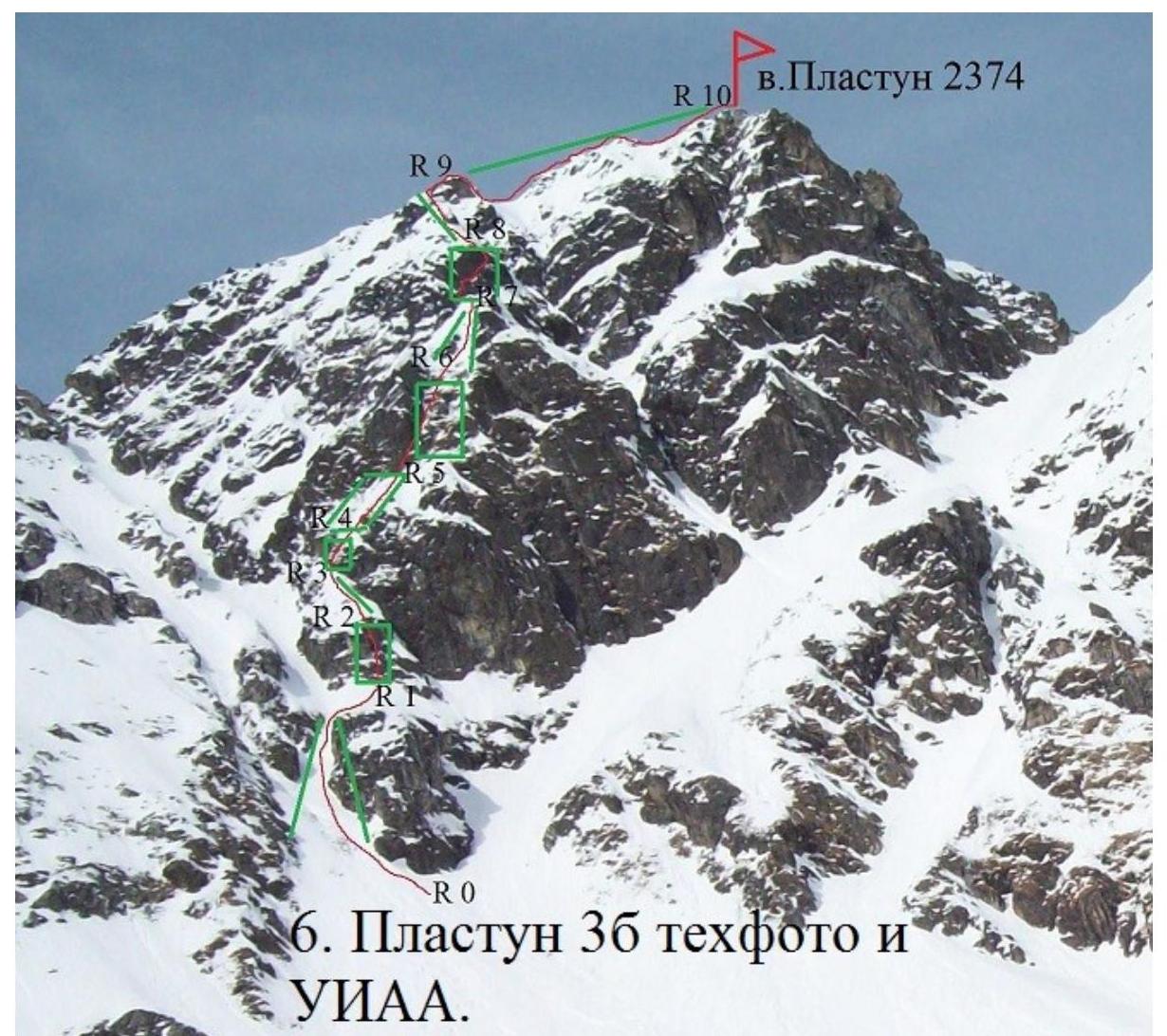
Route description for Mt. Plastun (2374 m) via the Southeast wall, rated 3B category.
From the base camp at Serebryanoe lake to the foot of the mountain, 1 hour walk on snowshoes through the Serebryanoe valley.
The start of the route is at the foot of the snow slope under the Southeast-facing wall at an altitude of 2020 m above sea level.
Section 0–1 200 m, 35°, I category. Approach to the lower rock outcrop of the SE wall of Mt. Plastun via an avalanche-prone snow slope to an altitude of 2150. The lower rock outcrop is bypassed on the left. Exit onto a snowy ridge at the top of a rocky outcrop. Convenient spot for tying in.
Section 1–2 20 m, 70°, III category. Through the left part of the rock wall. 4 pitons.
Section 2–3 25 m, 45°, I+ category. Snowy ridge.
Section 3–4 20 m, 60°, III category. Rocks of moderate difficulty. 4 pitons.
Section 4–5 30 m, 50°, II category. Snowy slope, to the right.
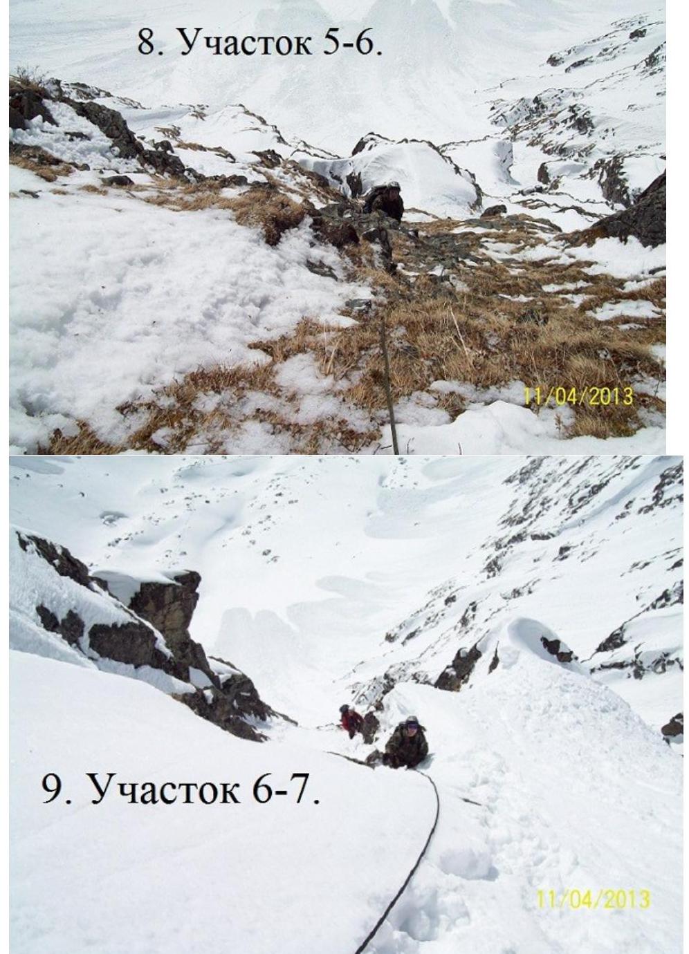
Section 5–6 45 m, 60°, III+ category. Grass-covered internal angle — "trough". 6 protection points.
Section 6–7 45 m, 50°, II+ category. Snowy couloir and ridge. Exit onto a narrow ridge with a snowy cornice. 2 protection points.
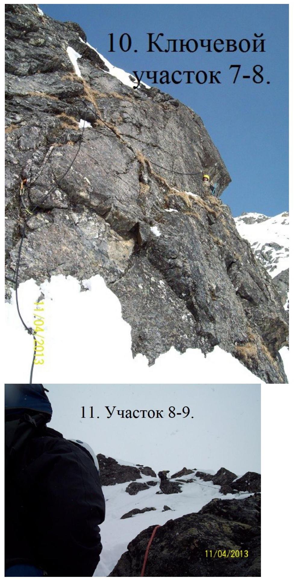
Section 7–8 40 m, 80°, IV-category. Rock wall, to the right around the corner. 8 protection points. Key section of the route. 5 ropes from section 1. Exit onto a ridge in the upper part of the counterfort.
Section 8–9 45 m, 55°, III-category. Rocky, blocky, snowy ridge. Protection via rock outcrops. Exit onto the South ridge.
Section 9–10 100 m, 20°, II+ category. Along the ridge to the summit. Protection via rock outcrops.
Mt. Plastun summit 2374 m. The summit is a jumble of rocks, possibly man-made. No notes, cans, or other items found.
Descent via the ascent route, 6 rappels.
UIAA scheme.
| Mt. Plastun 3B. | Length b m | Slope a° | Difficulty b | Number of pitons | |
|---|---|---|---|---|---|
| pitons B | chocks e | ||||
| □ | |||||
| 100 | 20 | I+ | 1 | ||
| --- | --- | --- | --- | --- | --- |
| 45 | 55 | III− | 1 | 2 | |
| 40 | 80 | IV− | 4 | 4 | |
| 45 | 50 | II+ | 2 | 1 | |
| 45 | 60 | III+ | 3 | 3 | |
| 30 | 50 | II− | 2 | ||
| 20 | 60 | III− | 2 | 2 | |
| 25 | 45 | I+ | |||
| 20 | 70 | III− | 2 | 3 | |
| 100 | 10 | II− | |||
| 100 | 10 | I+ |
- Panorama of Vetryany, from the Tunkinskaya valley to the right.
- Section 1–2.
- Section
5–6.
- Section
8–9.
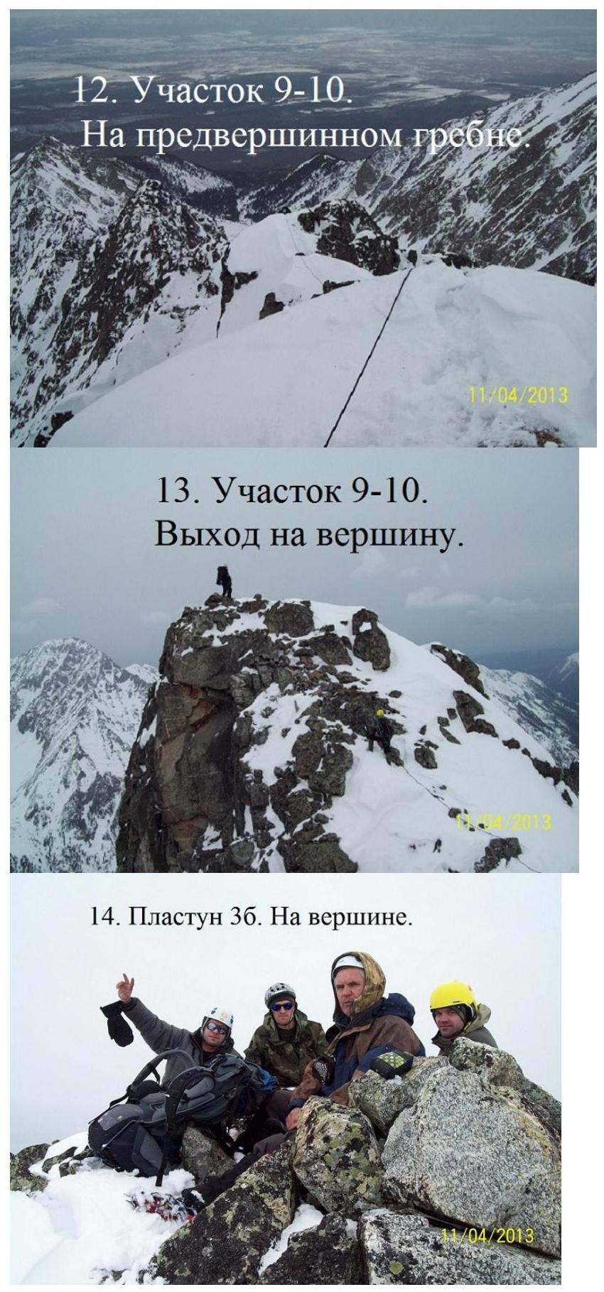
- Section 9–10.
Ascent to
the summit.
- Plastun 3B. On
the summit.
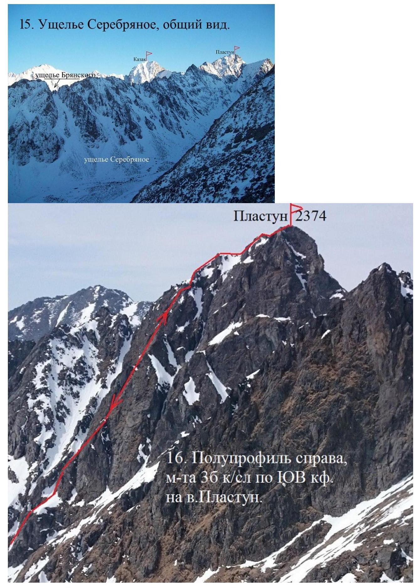
1B. Ascent profile to the right, mett 36 category via the SE ridge to Mt. Plastun