EASTERN SAYANS
IRKUTSK peak (2742 m) via the south ridge, cat. 3B difficulty (year-round)
GEOGRAPHICAL LOCATION
The Irkutsk peak is situated in the main ridge of the Tunkinskiye Belki range in the Eastern Sayan Mountains. It is located at the head of the Pravaya Zun-Khandagai River gorge.
TRANSPORTATION AND APPROACH TO THE BASE CAMP
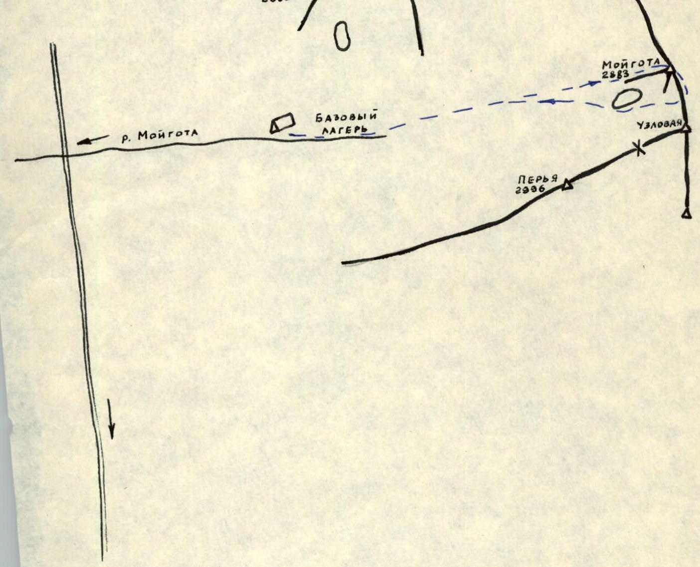
From Irkutsk city, take a bus or drive to Arshan resort — 218 km. From Arshan resort, head west along the main ridge through Tagarkhay village by car or on foot — 12 km.
Continue on foot along the trail on the right side (as you go) of the Zun-Khandagai River gorge until the fork of the left and right Zun-Khandagai rivers — 9 km. The base camp is located at the fork. The tree line is at this elevation, and there is an abundance of firewood.
Time breakdown:
- Irkutsk–Arshan — 7 hours by bus
- Arshan–base camp — 2 days (15 hours of walking time)
APPROACH TO THE ASSAULT CAMP
From the base camp, follow the Pravaya Zun-Khandagai River upstream to the second upper lake, from which it originates. The lake is situated in a cirque bounded by the south and west ridges of the Irkutsk peak.
The assault camp is set up on the lake's shore at an altitude of 2218 m. The walking time is 4 hours.
CLIMATIC CONDITIONS
The ascent to the Irkutsk peak was made in early May. The weather was sunny. The air temperature at the base camp level (1890 m) rose to +5 °C during the day and dropped to −10 °C at night. There was no snow on the lower third of the trail when approaching the base camp. The remaining two-thirds of the path through the gorge were snowy, and the upper part was icy. The base camp area and above were completely snow-covered, with rivers frozen and ice forming. In the afternoon, the snow became soggy and loose, and wet snow formed on the river ice. It is recommended to approach the base camp and assault camp early in the morning when there is still a crust on the snow. In the afternoon (after 12:00), the snow slopes on the approaches to the assault camp and the snow slopes of the Irkutsk peak's cirque are prone to avalanches. While at the assault camp on May 4th at 16:00, we witnessed a massive avalanche that descended into the lake from the slopes of the west ridge of the Irkutsk peak. The assault camp is situated on a high lake shore near the river's source and is safe from avalanches.
ROUTE DESCRIPTION
Ascent to the Irkutsk peak via the south ridge. The peak's elevation is 2742 m. The route is categorized as 3B difficulty year-round. The ascent was completed on May 5, 1975.
Group members:
- Tsionik A.L. — 2nd sports category
- Kharlamov V.M. — 2nd sports category
- Belousov V.M. — Candidate Master of Sports
- Vorobyova N.N. — 1st sports category
APPROACH TO THE START OF THE ROUTE
From the assault camp, cross the lake to approach the snowy slope at the beginning of the route. The approach takes 10 minutes.
Section R0–R1 (Photo #1)
Ascend the snowy slope upwards for 200 m towards the couloir that leads to the right saddle between the first tower and the ridge. Initially, the couloir is wide with a 35° slope, becoming narrower with a 55° slope in the upper part, and has a snow cornice overhanging from the saddle. The couloir is 100 m long. Traverse the lower part simultaneously, and the upper part with alternating rope pitches using an ice axe for protection. Exit onto the saddle via the left edge of the cornice. There is a control cairn #1 on the saddle.
Section R1–R2 (Photo #3)
From the saddle, traverse a sloping shelf at 20° with the first tower on your right for 20 m. Then, ascend 40 m up a 45° rock wall to reach the first tower. Use piton protection, with two pitons placed. The climbing is moderate, with good handholds and monolithic rocks.
Section R2–R2′
Traverse a broad, horizontal ridge for 40 m simultaneously until reaching an ascent.
Section R2′–R2″ (Photo #4)
Bypass the ascent of the first tower on the left via a traverse across a snow-covered wall with a 60° slope. The section is 40 m long, traversed alternately with piton protection and using rock outcrops, with two pitons placed. The difficulty is moderate.
Section R2″–R3 (Photo #5)
Descend from the first tower, keeping to the right side: 20 m down a narrow "knife-edge" at 45°, followed by 10 m down a vertical wall to a saddle. The climbing is moderate. Rocks are monolithic. Move with alternating rope pitches. Use rock outcrops for protection. Place two pitons on the saddle for the last climber's protection as they descend with top-rope. The saddle is very narrow.
Section R3–R4
Ascend onto the third tower from the saddle via monolithic rocks on the right for 10 m, then upwards along a rock wall for 60 m to reach the ridge. Move with alternating rope pitches, using rock outcrops and piton protection; three pitons are placed. The climbing is moderate.
Section R4–R5
Move along a narrow, jagged ridge to its upper part. The section is 90 m long. Move simultaneously, using rock outcrops to secure the rope.
Section R5–R6
Descend 40 m from the second tower onto a narrow saddle via snow-covered rocks at a 40° slope. The climbing is easy. Use rock outcrops for protection, and move with alternating rope pitches. There is a control cairn #2 on the saddle.
Section R6–R7
From the saddle, traverse a snowy shelf: first, 15 m to the left of the third tower, then 20 m upwards along snow-covered rocks. The climbing is below moderate difficulty. Place two pitons on the saddle: one for the last climber's protection from the second tower and one for the first climber's lead onto the third tower. Move with alternating rope pitches. Use piton and rock outcrop protection.
Section R7–R8
Traverse a narrow ridge of the third tower for 70 m. Move with alternating rope pitches, using rock outcrops for protection. Rocks are monolithic and easy to climb.
Section R8–R9
Descend 35 m from the third tower via easy climbing on snow-covered rocks with alternating rope pitches and rock outcrop protection onto a saddle. The saddle is narrow and has a snow overhang.
Section R9–R10 (Photo #6)
From the saddle, ascend 10 m up the ridge of the fourth tower, then bypass it on the right via a traverse along the boundary between rocks and snow lying on slabs. The slope is 45°. Rocks are monolithic slabs. The section is 70 m long. Move with alternating rope pitches, using piton and rock outcrop protection; three pitons are placed. The climbing is of moderate difficulty. Exit onto a saddle between the fourth and fifth towers.
Section R10–R11
Traverse the fifth tower for 50 m along snow-covered slabs at 45°, keeping to the right, and exit onto a wide, talus-filled shelf under the wall. Move with alternating rope pitches, using piton and rock outcrop protection. Three pitons are placed. The climbing is of moderate difficulty.
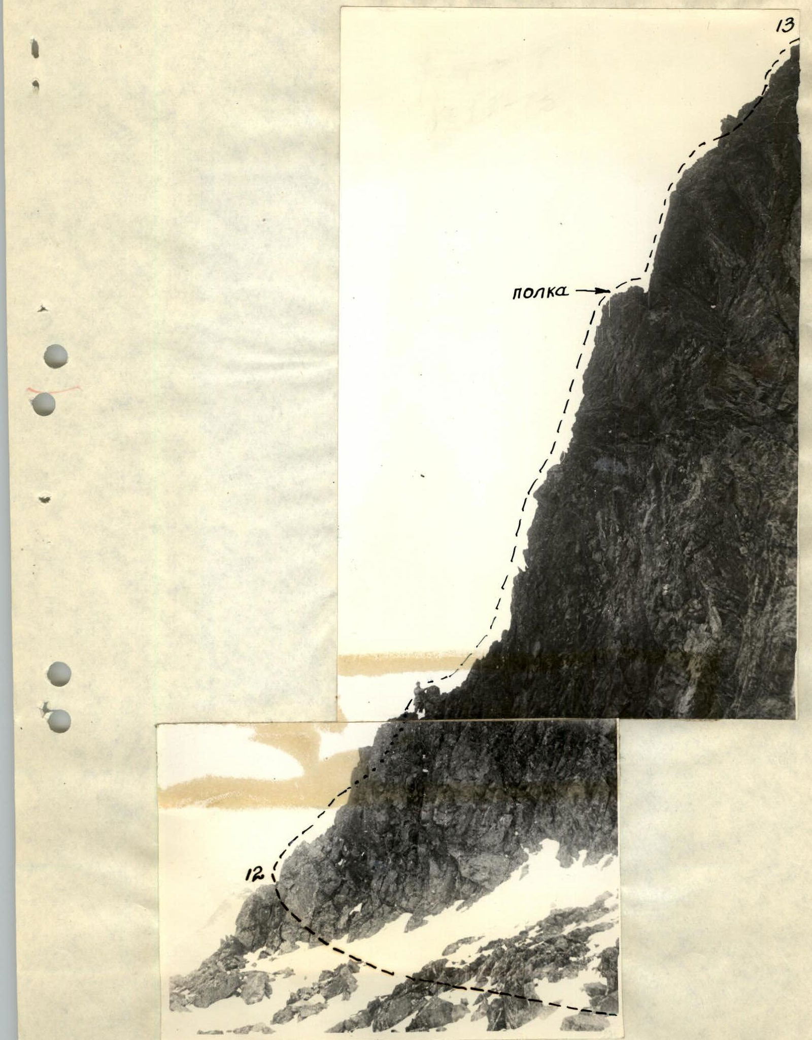
Section R11–R12 (Photo #1, 7)
Traverse a broad, talus-filled ridge that transitions into a shelf on the left of the wall for 100 m. This section is easy and traversed simultaneously. The shelf abuts a pronounced buttress, which is used to overcome a rust-colored wall.
Section R12–R13
The ascent up the wall for 90 m goes to the left of the rust-colored patch via a pronounced buttress (see Photo #7). In the lower part of the buttress, the climbing is easy (15 m), with protection through rock outcrops. Further, 30 m of climbing is above moderate difficulty (Photo 8) until reaching a sloping shelf (Photo 7), with piton protection. The group can assemble on the shelf. Above the shelf, there are 8 m of difficult climbing (Photo 9) with piton protection. The slope of the sections with challenging climbing is 70°. Rocks are clean and monolithic, with good handholds. Then, exit onto the upper part of the wall; the slope is 45°. The wall is snow-covered with loose rocks. The section is 55 m long, traversed alternately with protection through rock outcrops and ice axe. The wall transitions into a pre-summit ridge.
A total of seven pitons are placed on the wall, with good rock outcrops available for protection and self-arrest.
Section R13–R13′ (Photo #1, 2)
The pre-summit ridge is initially horizontal, narrow, very jagged, and snow-covered for 80 m. Traverse this section simultaneously, securing the rope to rock outcrops. The pre-summit ascent of the ridge is 250 m, with a slope of up to 30°, heavily snow-covered. Traverse this section alternately with protection through ice axe and, keeping to the right side of the ridge. Bypass a rock outcrop before the summit on the right. Use rock outcrops for protection. One piton is placed. After the rock outcrop, there is an easy exit to the summit along a broad ridge. The ascent time was 9 hours and 45 minutes.
DESCENT
Descend to the shelf under the wall (sections R14–R13–R12) via the ascent route. Traverse the ridge with alternating rope pitches using an ice axe; descend from the wall via rappel with rope retrieval.
Continue from the broad shelf under the wall downwards along a broad, not very pronounced western couloir. The couloir's slope is up to 50°. In the upper part, 50 m (sect. R15–R16) are traversed alternately with protection through rock outcrops and ice axe; in the middle and lower parts, 80 m are descended via rappel with rope retrieval.
The couloir leads onto a snowy slope with a 35° slope and a length of 250 m. Descend the slope simultaneously until reaching the snowy fields of the cirque. The descent time is 4 hours.
After descending, the path to the assault camp takes 0.5 hours and follows snowy fields and the lake.
The group believes that the route corresponds to category 3B difficulty under year-round conditions.
TABLE OF MAIN ROUTE CHARACTERISTICS
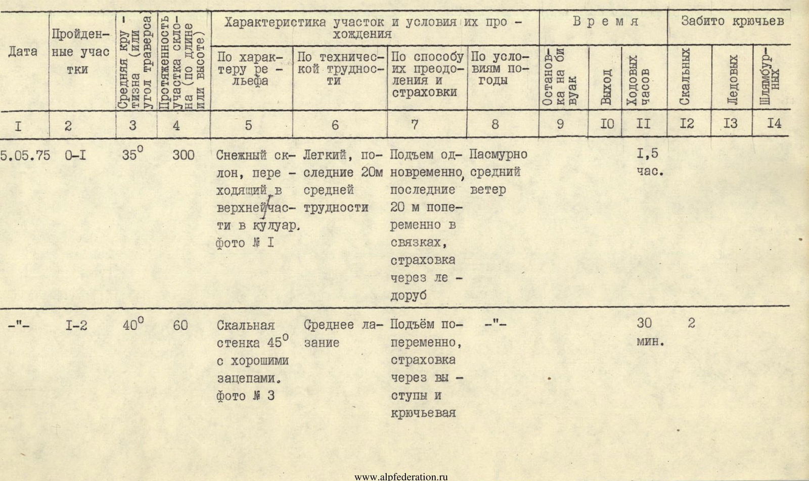

| Date | Sections traversed | Average slope (or traverse angle) | Section slope length (by length or height) | Terrain characteristics | Technical difficulty | Method of overcoming and protection | Weather conditions | Stop for bivouac | Exit | Working hours | Rock | Ice | Bolted |
|---|---|---|---|---|---|---|---|---|---|---|---|---|---|
| 5.05.75 | R0–R1 | 35° | 300 | Snowy slope transitioning into a couloir in the upper part. Photo #1 | Easy, last 20 m of moderate difficulty | Ascent simultaneously, 20 m in teams with alternating rope pitches, protection through ice axe | Overcast, moderate wind | – | – | 1 h 30 min | 0 | 0 | 0 |
| –"– | R1–R2 | 40° | 60 | Rock wall at 45° with good handholds. Photo #3 | Moderate climbing | Ascent with alternating rope pitches, protection through rock outcrops and pitons | –"– | – | – | 30 min. | 2 | 0 | 0 |
| –"– | R2–R2′ | 0° | 40 | Broad ridge | Easy | Simultaneous passage | –"– | – | – | 5 min. | 0 | 0 | 0 |
| –"– | R2′–R2″ | 0° | 40 | Wall at 60°, snow-covered on ledges. Photo #4 | Moderate difficulty | Traverse with alternating rope pitches, piton and rock outcrop protection | –"– | – | – | 30 min. | 2 | 0 | 0 |
| –"– | R2″–R3 | 45° | 30 | Snow-covered rocks, narrow "knife-edge" 20 m, vertical wall 8 m | Moderate climbing | Descent with alternating rope pitches and rock outcrop protection | –"– | – | – | 20 min. | 0 | 0 | 0 |
| –"– | R3–R4 | 50° | 60 | Rocky ridge with steep slopes | Moderate climbing | Ascent with alternating rope pitches and piton protection | –"– | – | – | 1 h | 3 | 0 | 0 |
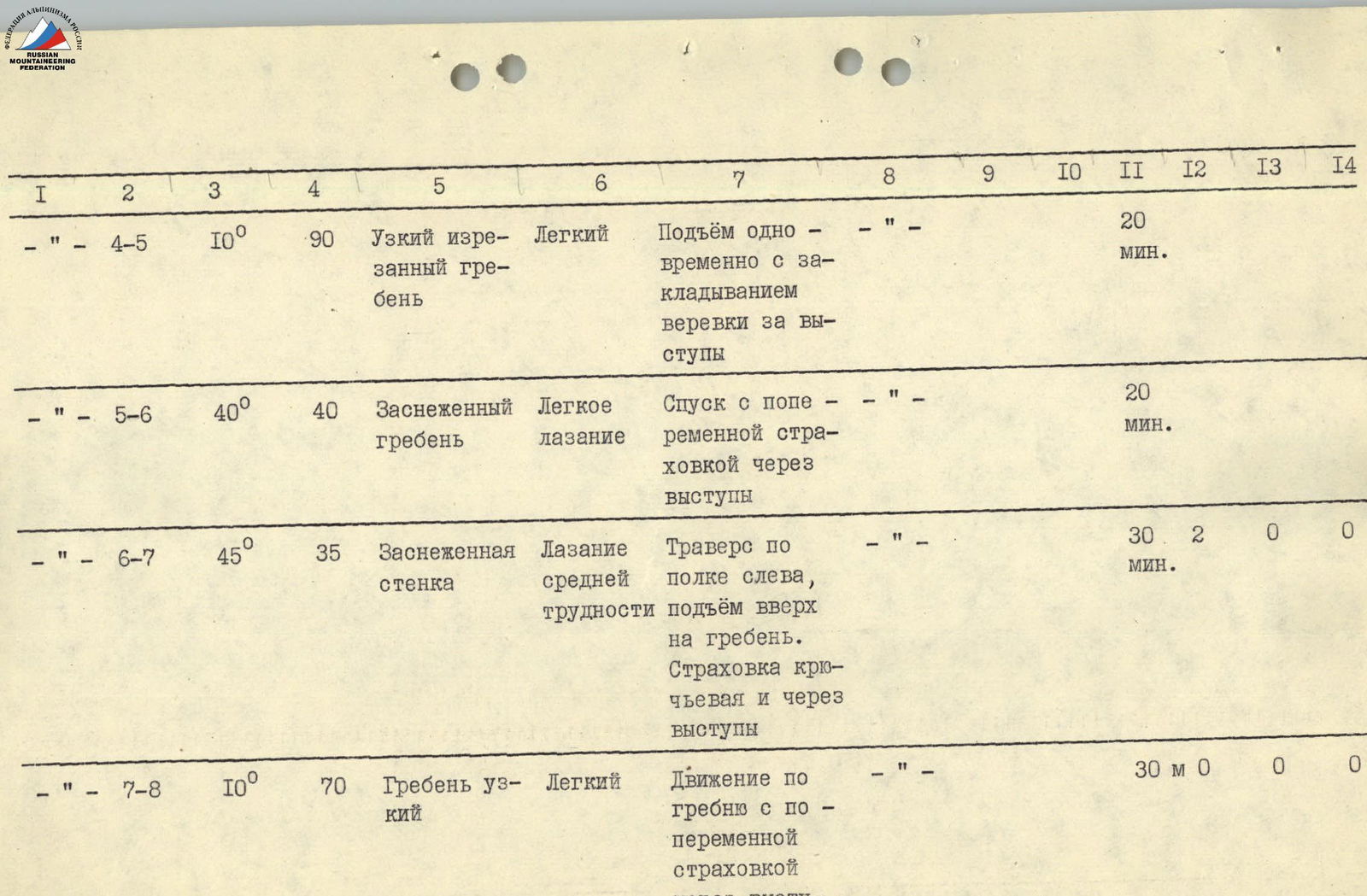
| –"– | R4–R5 | 10° | 90 | Narrow, jagged ridge | Easy | Ascent simultaneously, securing rope to rock outcrops | –"– | – | – | 20 min. | 0 | 0 | 0 |
| –"– | R5–R6 | 40° | 40 | Snow-covered ridge | Easy climbing | Descent with alternating rope pitches and rock outcrop protection | –"– | – | – | 20 min. | 0 | 0 | 0 |
| –"– | R6–R7 | 45° | 35 | Snow-covered wall | Climbing of moderate difficulty | Traverse along a shelf on the left, ascent onto the ridge. Piton and rock outcrop protection | –"– | – | – | 30 min. | 2 | 0 | 0 |
| –"– | R7–R8 | 10° | 70 | Narrow ridge | Easy | Movement along the ridge with alternating rope pitches and rock outcrop protection | –"– | – | – | 30 min. | 0 | 0 | 0 |
| –"– | R8–R9 | 60° | 35 | Snow-covered rocks | Easy climbing | Descent with alternating rope pitches and rock outcrop protection | –"– | – | – | 20 min. | 0 | 0 | 0 |
| –"– | R9–R10 | 0° | 70 | Snow-covered slabs at 45°, Photo #6 | Moderate passage | Traverse along the boundary between snow and rocks. Piton and rock outcrop protection | –"– | – | – | 40 min. | 3 | 0 | 0 |
| –"– | R10–R11 | 0° | 50 | Snow-covered slabs at 45° | Moderate passage | Traverse along the boundary between snow and rocks. Piton and rock outcrop protection | –"– | – | – | 30 min. | 3 | 0 | 0 |
| –"– | R11–R12 | 0° | 100 | Broad, snow-covered ridge | Easy | Simultaneous passage | –"– | – | – | 10 min. | 0 | 0 | 0 |
| –"– | R12–R13 | 70° | 80 | Monolithic wall with good handholds. Photos 7, 8, 9 | 15 m easy climbing, then 40 m difficult climbing. The rest is moderate climbing | Moderate and difficult climbing with piton protection | Quiet, wet snow | – | – | 2 h | 7 | 0 | 0 |
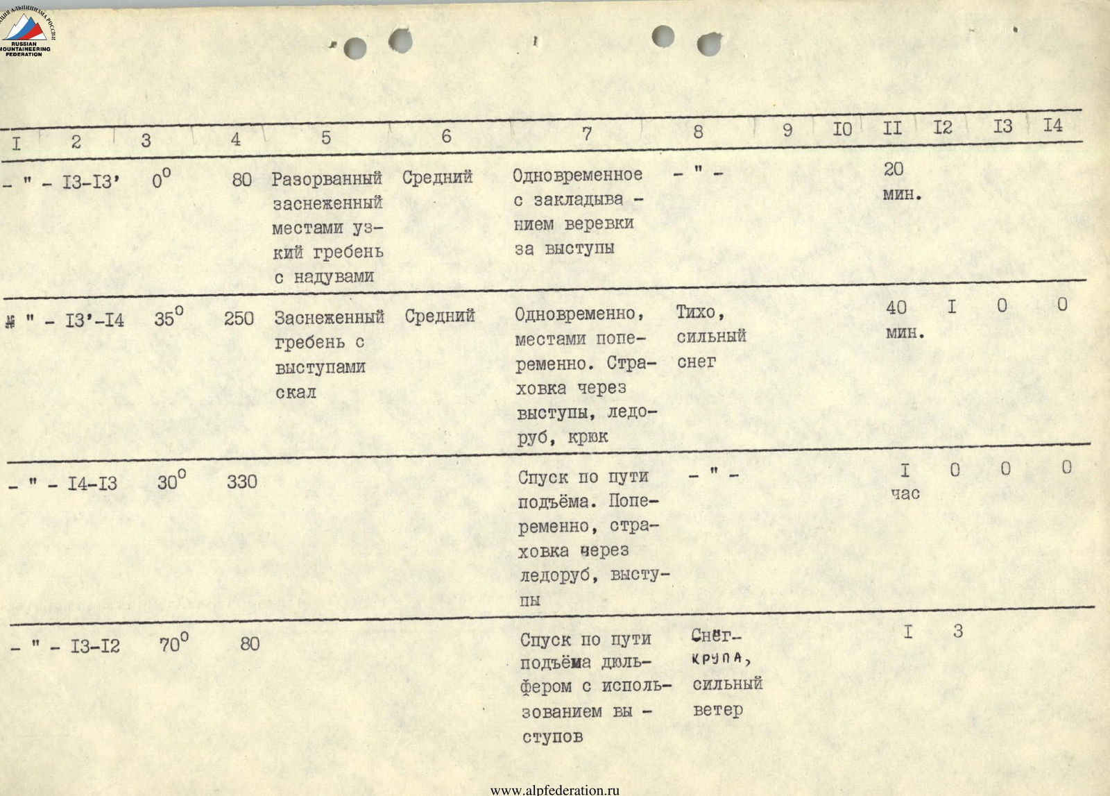
| –"– | R13–R13′ | 0° | 80 | Jagged, snow-covered ridge, partially narrow with snowdrifts | Moderate | Simultaneous passage with securing rope to rock outcrops | –"– | – | – | 20 min. | 0 | 0 | 0 |
| –"– | R13–R14 | 35° | 250 | Snow-covered ridge with rock outcrops | Moderate | Simultaneous, partially alternating. Protection through rock outcrops, ice axe, piton | Quiet, heavy snow | – | – | 40 min. | 1 | 0 | 0 |
| –"– | R14–R13 | 30° | 330 | Descent via the ascent route. Alternating rope pitches, protection through ice axe and rock outcrops | –"– | – | – | 1 h | 0 | 0 | 0 | ||
| –"– | R13–R12 | 70° | 80 | Descent via the ascent route via rappel using rock outcrops | Snow-gravel, strong wind | – | – | 1 h | 3 | 0 | 0 | ||
| –"– | R15–R16 | 35° | 50 | Broad, snow-covered couloir with rock outcrops | Moderate | Descent with alternating rope pitches and rock outcrop and ice axe protection | Blizzard, cold | – | – | 30 min. | 0 | 0 | 0 |
| –"– | R16–R17 | 45–50° | 80 | Broad couloir with rock outcrop steps | Difficult | Sport descent with rope retrieval and use of pitons | Stormy wind with snow | – | – | 1 h | 4 | 0 | 0 |
| –"– | R17–R18 | 40° | 300 | Snowy slope | Easy | Simultaneous descent | –"– | – | – | 30 min. | 0 | 0 | 0 |
| TOTAL: | 14 h 15 min | 30 | 0 | 0 |
13 TOWN OF PAROH.