34
Geographic and Climbing Characteristics of the Area
The Zuun-Khandagai valley is located 15 km from the Arshan resort village.
There is a good trail almost halfway through the valley. The peaks in this area have been explored by climbers for a long time, and the Classification table currently includes routes to:
- Mt. SOAN - 4B and 3B
- Mt. Dinosaur - 4A
- Khandagai Needles - 4B
The first ascent to the left peak of Khandagai Needles is related to ridge routes. This route is distinguished by its logic and complexity, as it runs along the main watershed ridge of the Tunkin Mountains, characterized by sharp alpine forms (narrow jagged ridges, abundant snow, strong winds, etc.).
Winter climbing conditions persist until mid-May.
Protocol 4209 dated February 15, 1977.
343, p/p.
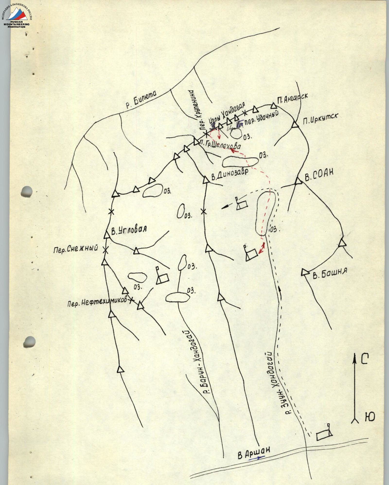
Map of the area
Description
Ascent to Khandagai Needles via the western ridge from Krupenin Pass.
From the base camp at the forest boundary (1700 m), the approach to the pass along a ready-made trail and frozen snow crust took 3 hours 30 minutes. The weather is excellent.
Section R0–R1
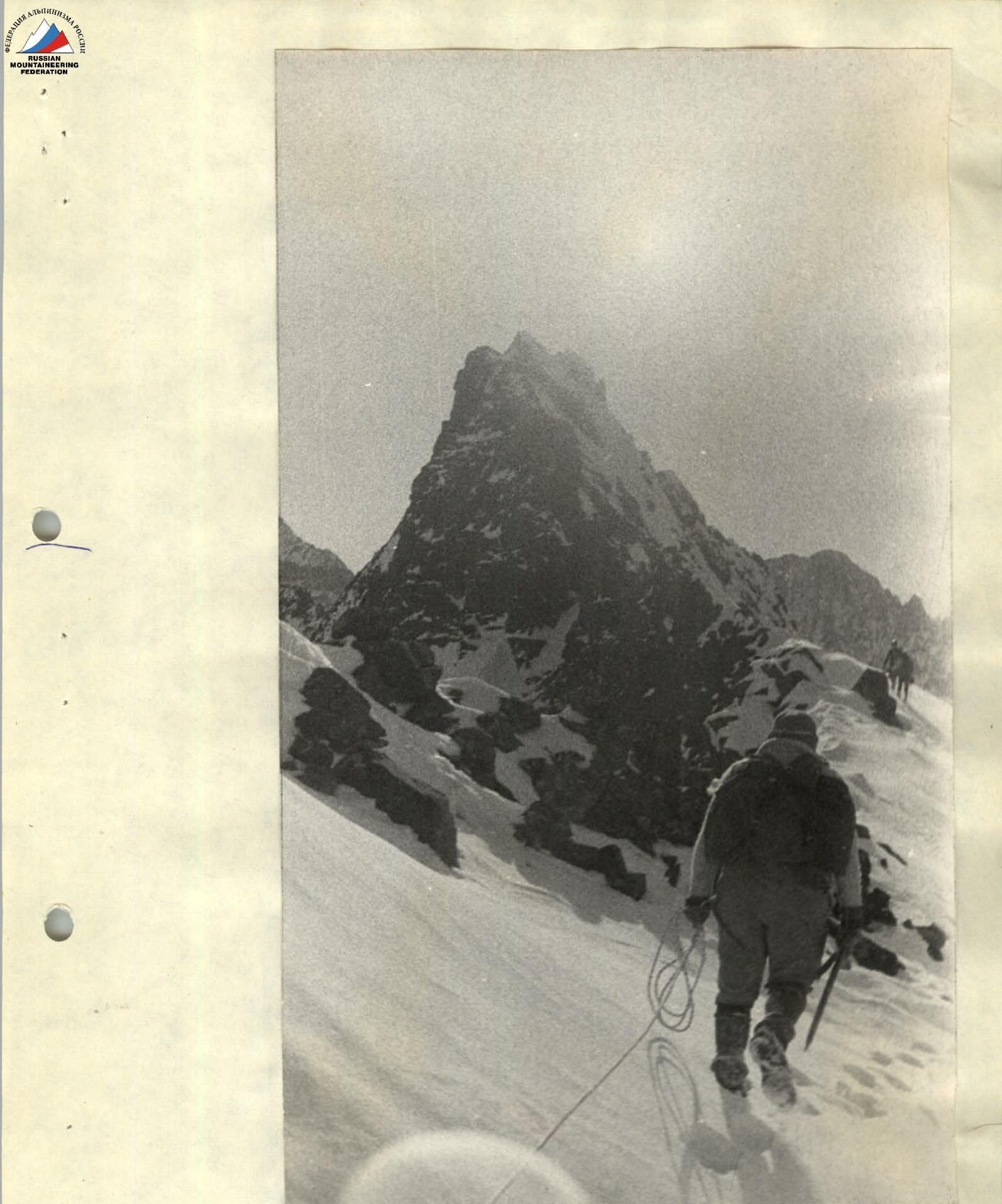
The first part of the route is a snowy ridge, dropping steeply to the left with a large wall. We move 15 minutes along it to the first rise of the ridge (Photo 2).
Section R1–R2
Easy snowy rocks, 40° steep, are traversed alternately, with protection through outcrops (Photo 3), and we approach the second rise.
Section R2–R3
From here, the main work begins. Movement is to the right upwards along snowy ledges and loose rocks to the ridge (Photo 4) alternately. Protection is through outcrops. Before reaching the ridge, there is ice under the snow. We set up a rope. Steepness is 50° (Photos 5,6). Further movement is along a narrow, destroyed ridge (Photo 7) with overcoming rock walls (2–3 m) with assistance (Photo 8). Soon the ridge turns into a rocky "palisade". Climbing is complex, with loose rocks under the snow. Protection is through outcrops (Photo 9).
Descent from the "palisade" is along smooth slabs 80° steep. 30 m rappel with rope retrieval (Photo 10).
Section R3–R4
Bypassing a large boulder on the left, we approach the wall of the "Tooth" (Photo 1). To the right, on a large detached boulder, there is a convenient place for protection (Attention! Between the boulder and the wall, there is a deep crevice filled with snow). The Tooth is bypassed along the wall to the right upwards, with an exit to the next bridge. Protection is with pitons, rope (Photos 11,12). One rope, three pitons.
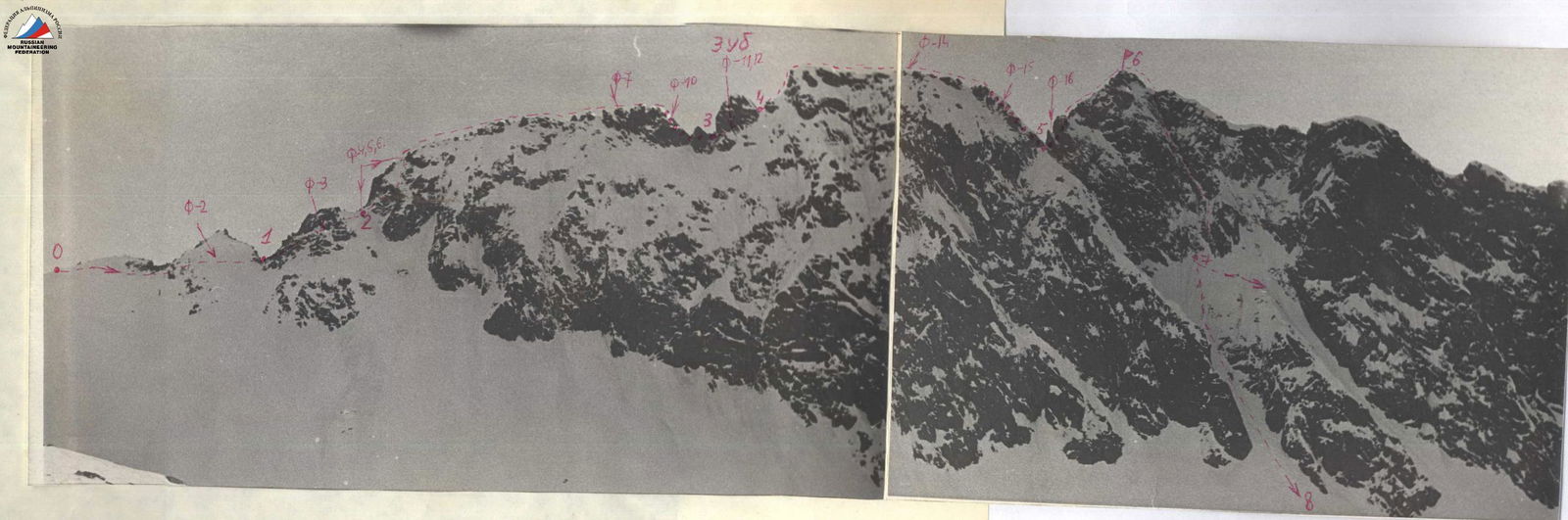
Panorama of the route. Photo 1.
Section R4–R5
Having overcome alternately a snowy rocky rise (Photo 13), we move along a very narrow ridge with snowy cornices. Movement is alternate through outcrops (Photo 14). Descent into the last depression is along a wall 85° steep, rappel with rope retrieval 25 m (Photo 15).
Section R5–R6
The pre-summit rise is bypassed along snowy rocks to the left. Climbing is complex, protection is through outcrops. One rope with protection (Photo 16) leads to the ridge. Further, with alternate and simultaneous movement, three ropes lead to the summit. From the pass to the summit, it takes 5 hours.
Section R6–R7
Descent from the summit is along the 10-B counterfort, 15 m. We tie a loop and, having hacked through a large snowy cornice, descend along a vertical chimney to the right into a couloir. Adhering to the left wall, which provides good protection from falling ice and snow, with piton protection, we organize three rappels with rope retrieval and descend onto a snowy ledge.
Section R7–R8
From the ledge, straight down, alternately and simultaneously, into a large couloir with signs of a recent avalanche, and along it into the cirque (Attention! In case of complex snowy conditions, descent along the left couloir is recommended. It is short, although steep. It was traversed in 1971 after a heavy snowfall). Indicated by an arrow on (Photo 1). From the summit to the cirque, it takes 2 hours. To the base camp, it takes 2 hours.
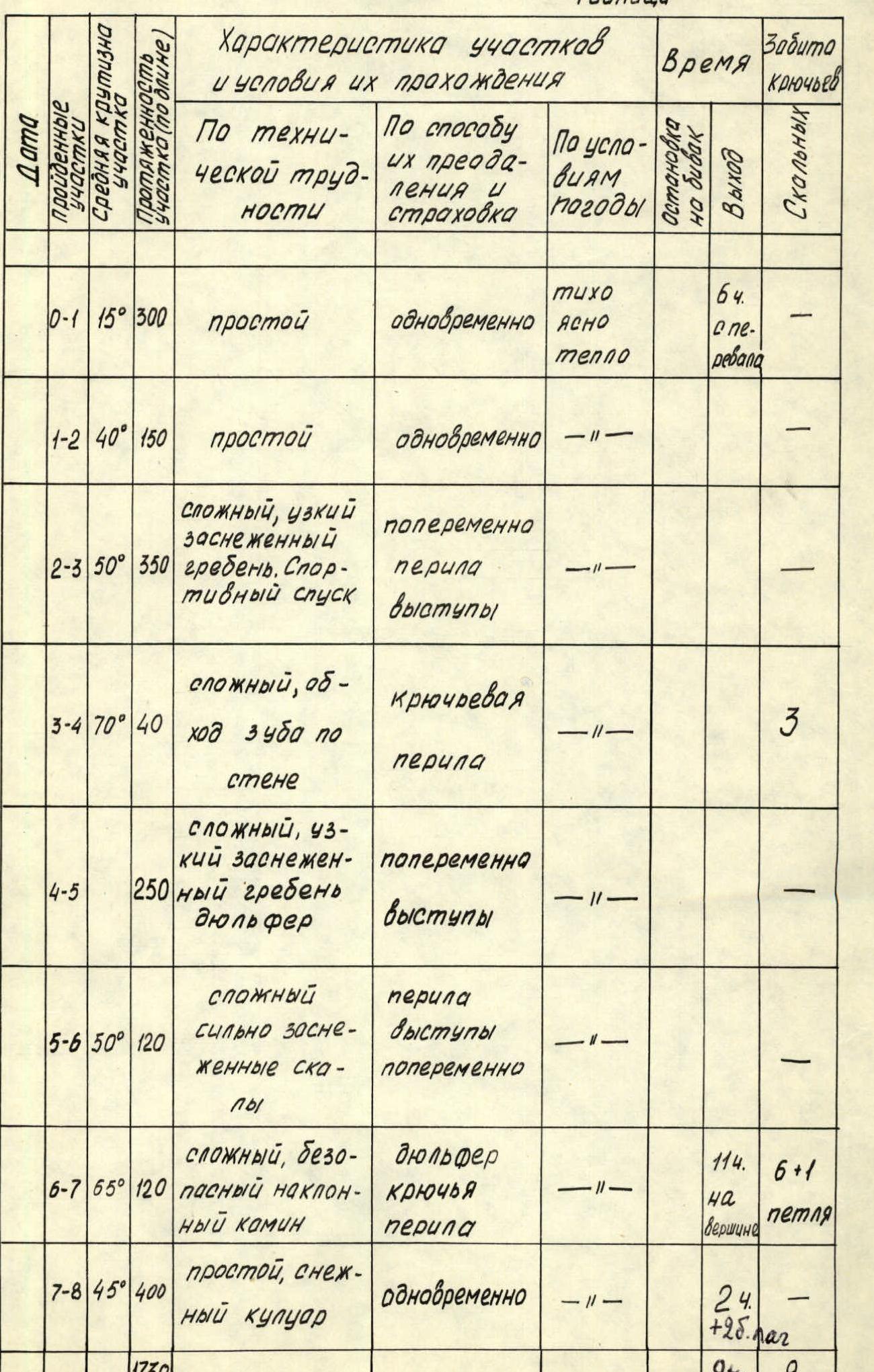
Table
| Section | Steepness | Length (m) | Technical Difficulty | Method of Overcoming and Protection | Weather | Stop for Bivouac | Time Taken | Pitons |
|---|---|---|---|---|---|---|---|---|
| R0–R1 | 15° | 300 | simple | simultaneous | calm, clear | 6 hours (from pass) | ||
| R1–R2 | 40° | 150 | simple | simultaneous | — | |||
| R2–R3 | 50° | 350 | complex, narrow snowy ridge. Sporty descent | alternate, rope, outcrops | — | |||
| R3–R4 | 70° | 40 | complex, bypassing the Tooth along the wall | piton, rope | — | 3 | ||
| R4–R5 | 250 | complex, narrow snowy ridge, rappel | alternate, outcrops | — | ||||
| R5–R6 | 50° | 120 | complex, heavily snowy rocks | rope, outcrops, alternate | — | |||
| R6–R7 | 65° | 120 | complex, safe inclined chimney | rappel, pitons, rope | — | 1 hour on summit | 6+1 (summit) | loop |
| R7–R8 | 45° | 400 | simple, snowy couloir | simultaneous | — | 2 hours (+2 hours to camp) | ||
| TOTAL | 1750 | 9 hours | 9 |
Section R0–R1. Photo 1

Section R2–R3. Photo