Irkutsk, 2011
Climbing Passport
- Eastern Sayan, Tunkin Goltsy ridge, Zuun-Khandagai river gorge.
Section number according to the classification table: 6.1.
- Domashnaya peak 2350 m (peak coordinates: 51°55′32.55″ N 102°13′4.44″ E), via the East Face
- Route difficulty category: proposed 5A category, first ascent
- Route type — rock climbing.
- Route elevation gain: 650 m
Route length: 1200 m
Length of sections:
- V category — 80 m
- VI category — 105 m
Average steepness:
- wall part of the route — 75°
- entire route — 50°
- Pitons left on the route: (total 4) 4 anchor pitons (including 1 for rappelling on section 9–10)
Used on the route:
- anchor pitons: 67/18
- chocks: 23/0
- bolt pitons: 0/0
-
- about 50 points of ITO on fifi hooks.
- Team's climbing hours: 11 h 40 min, No overnight stays
- Team leader: Glazunov Evgeny Vladimirovich (Candidate for Master of Sports)
Team members:
- Otmakhov Alexander Sergeevich (2nd sports category)
- Cherepanov Vladimir Valerievich (2nd sports category)
- Coach: Glazunov Evgeny Vladimirovich (Candidate for Master of Sports)
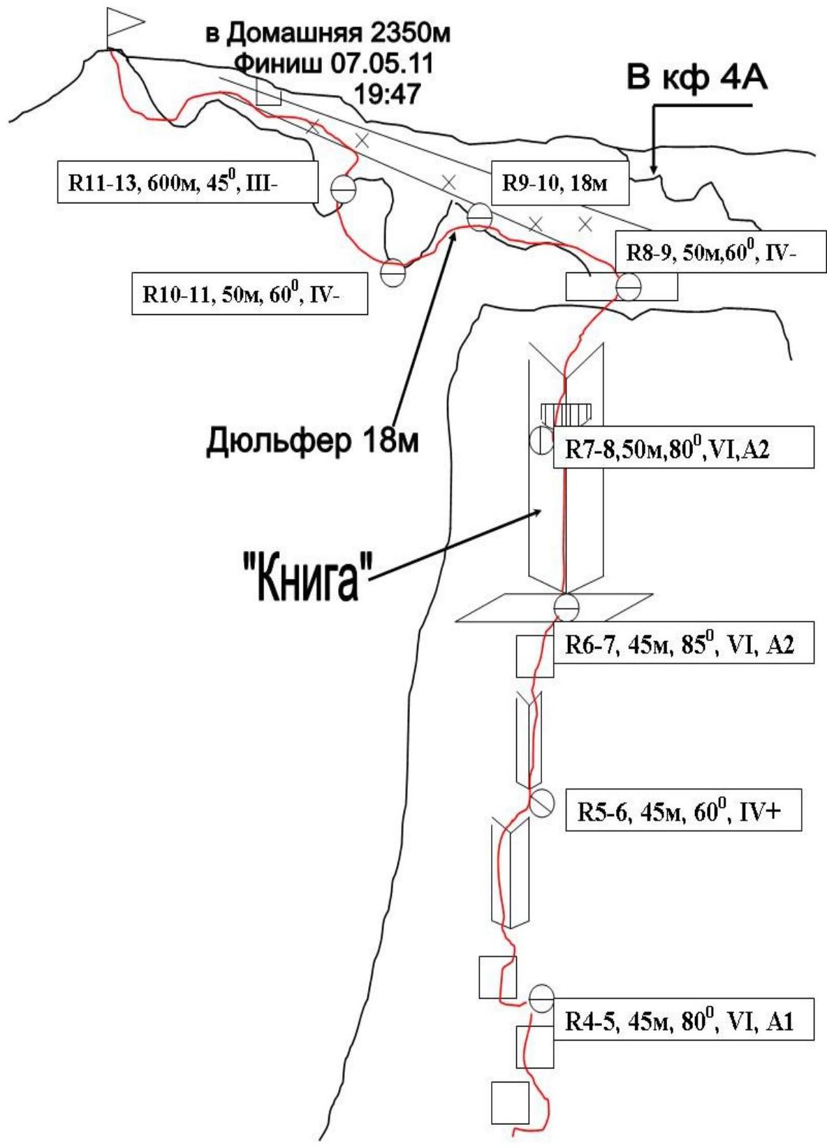
Exit to the route from the base camp: 7:00, May 7, 2011. Reached the summit — 19:47, May 7, 2011. Returned to the base camp — 21:30, May 7, 2011.
- Irkutsk Region Alpine Federation
Climbing Area and Route Characteristics, Team's Tactical Actions.
Domashnaya peak is located in the southeastern spur of the Tunkin ridge of the Eastern Sayan, which is the watershed between the Zuun-Khandagai and Baruun-Khandagai gorges. The treeline here is at an altitude of 1700 m, so in the lower part of the route, there is vegetation and individual trees, which complicates the passage and creates some inconvenience.
One classified route (4A, Afanasiev 79) has been laid on the peak, and there are several independent routes that have not been освоined yet.
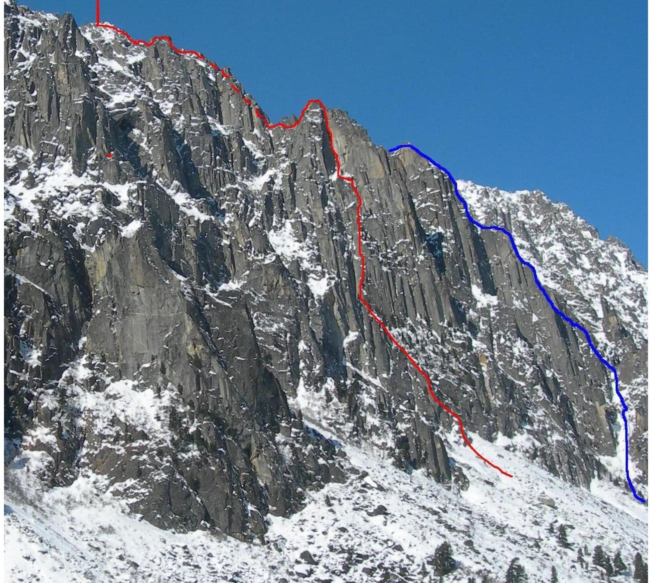
The route we chose passes through the steepest part of the East Face of the peak, through a hundred-meter vertical internal angle "Kniga" ("Book"), which is clearly visible and readable from below.
The route we completed is independent and the most logical on the face.
Observations of the face's condition were made over several days, and the optimal path was determined based on the terrain. The team started the ascent after a three-day prolonged snowfall: the leader constantly switched between rock shoes and crampons.
The ascent took place in diverse weather conditions:
- The wall part, including "Kniga", was climbed in sunny weather;
- As we moved along the ridge, the weather worsened: it started snowing;
- The descent took place in snowfall conditions.
The route we completed is characterized by a combination of interesting free climbing and challenging ITO on deaf cracks and terrain. The overall difficulty and intensity of climbing allow us to assess it as a very strong 5A. The route is significantly stronger than the classic "fives" on "Forossky Kant" peak in Crimea and rock "fives" A on Erydag peak. The line is comparable in difficulty to 5A routes in the following areas and on the following peaks:
- Eastern Sayan: "SOAN" peak, "Opasnaya" peak, "Bronenosets" peak
- Ergaki
- Baruzinsky ridge
- Kodar
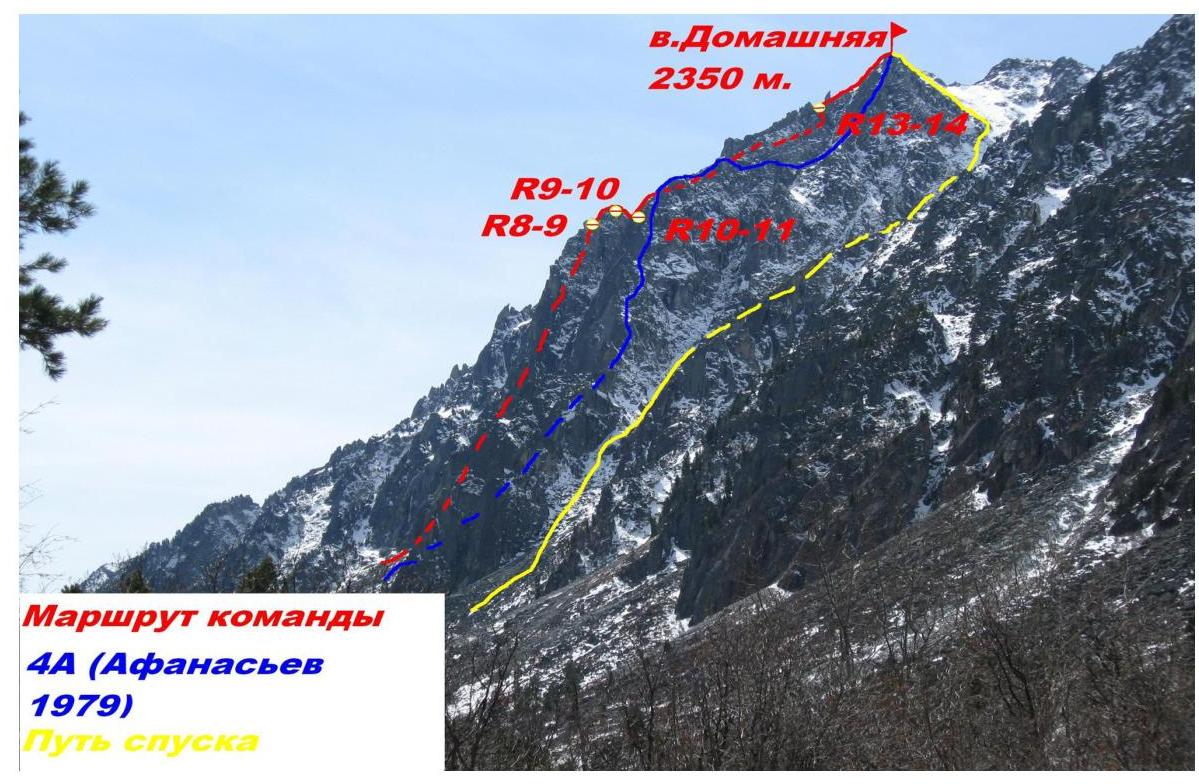
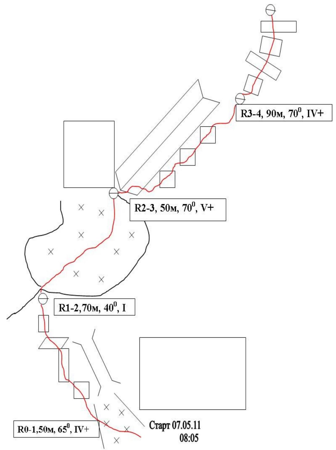
Route profile on the right and general view of the peak
Mt. Domashnaya 2060 m.
4A category route by Afanasiev 79 (visible part) Route of the first ascent General view of the peak
on the left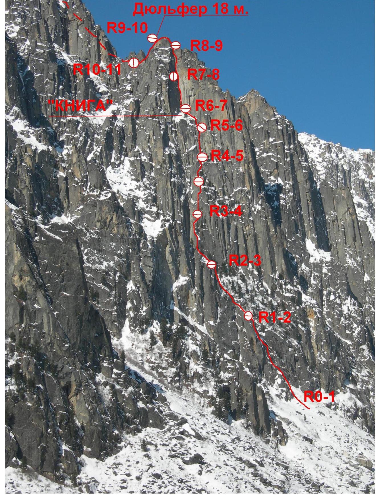
Wall part of the route
Route Description by Sections
R0–R1 Start from a characteristic snowfield towards an icy chimney, which is bypassed on the left by a series of walls. (With ice climbing gear, it's possible to climb the chimney.) Exit onto a small shoulder at the base of a snow mulde. (50 m. 65° IV+)
1–2 From the shoulder, climb up the snowfield, crossing the mulde, to reach the base of a large internal angle with a big rock at the bottom. (70 m. 40° I)
2–3 Two possible variations:
- Climb up the angle — mixed climbing + ITO.
- (In our case, the angle was filled with snow and water) Complex climbing to exit onto the right wall of the angle and move up along the edge. (Photo 1)
Both options are roughly equal in difficulty. (50 m. 70° V+)
3–4 Move towards "Kniga" — a series of logical moves with walls and ledges, a two-rope-length section. Exit under the base of the internal angle with deaf cracks filled with grass. (90 m. 70° IV+)
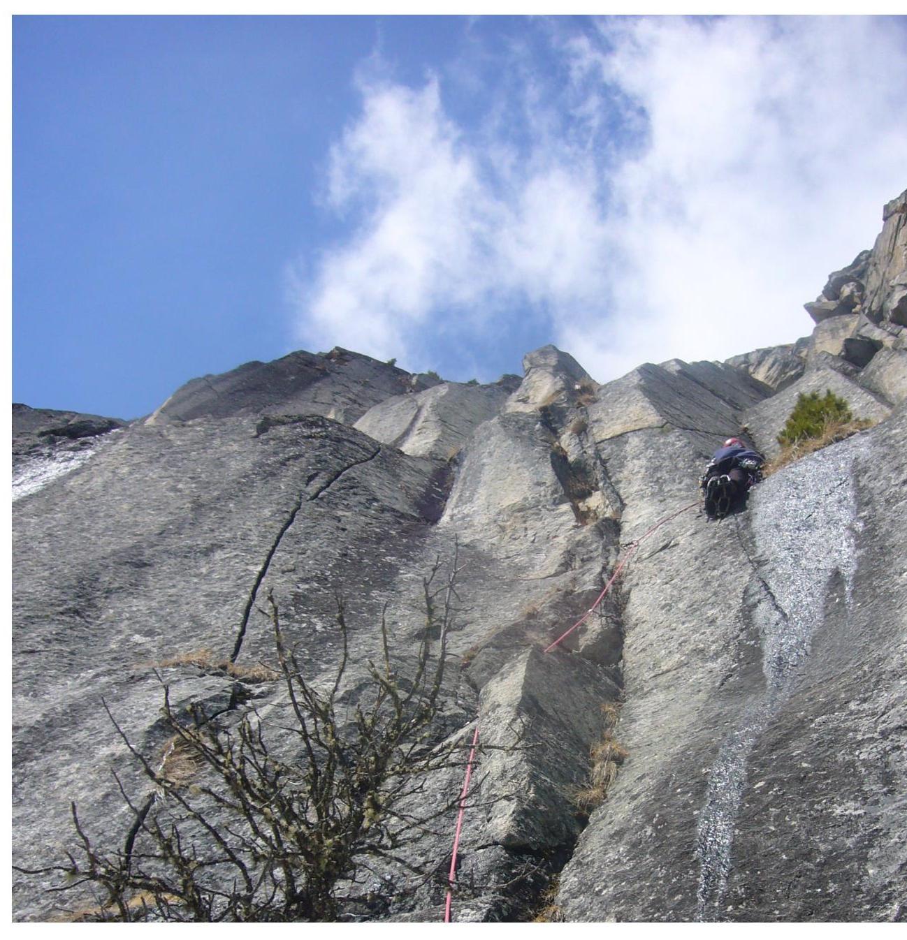
4–5 Climb a series of cracks (photo 2), alternating between free climbing and ITO, to reach a small ledge, slightly to the right (photo 3). Move towards "Kniga". (45 m. 80° VI A1)
5–6 Return slightly to the left into the angle, then climb up the angle to reach a large ledge at the base of "Kniga". (45 m. 60° IV+)
6–7. Key section — internal angle "Kniga". In the lower part, there are 2 rusty bolts with a rappel loop (not recommended for use!!!). No further signs of passage. Complex climbing alternates with long sections of ITO on deaf cracks filled with earth and crumbling rock. Exit onto a small ledge under an overhang. Station is inconvenient. (Photo 4) (45 m, 85°, VI A2)
7–8 Climb the overhang on deaf cracks (careful! rock crumbles under load). Then, the internal angle becomes less steep, and more destroyed terrain leads to a ridge. "Kniga" is completed! (50 m. 80° VI A2)
8–9 Climb monolithic cracks and walls on the ridge (photo 5). (50 m. 60° IV–)
9–10 Rappel 18 m from the ridge to a col in front of a gendarme. (Photo 6)
10–11 Bypass the gendarme on the left, then descend slightly, bypassing a monolithic gendarme on the right, to exit into a couloir between the ridge and the East counterfort, where the 4A route passes. (50 m. 60° IV–)
11–12 Climb up the couloir, bypassing the monolithic gendarme on the right, through small walls and a long angle, to return to the ridge. (300 m, 45°, III–)
12–13 Climb along the ridge through short rock walls to reach the summit. (300 m, 45°, III–)
UIAA Scheme (sheet 2)
UIAA Scheme (sheet
1)
11 (Photo 3) End of section
R4–R5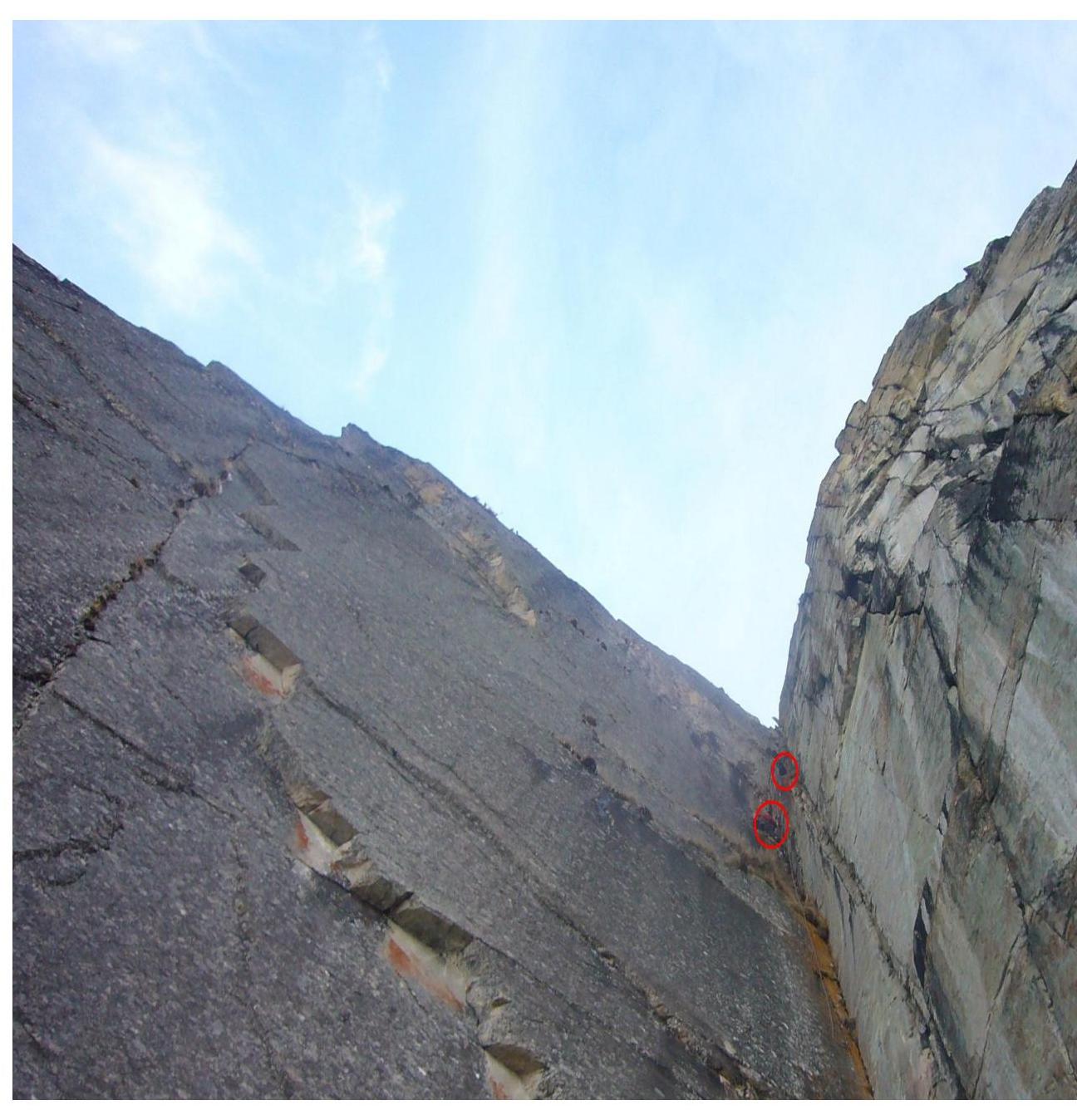
13 (Photo 4: "Kniga" angle) Work on section R7–R8 and railing on section R6–R7
Photo 6 (Rappel on section R9–R10)