Brief geographic overview of the area, sporting characteristics
The Dомашняя peak is located in the south-eastern spur of the Tunkinsky ridge of the Eastern Sayan, which is a watershed between the Zuun-Khandagai and Baruun-Khandagai gorges. Its height is 2352 m above sea level. In the same spur, there are two unnamed peaks, 2693 m and 2678 m, and the Dinosaur peak, 2820 m, for which there are classified routes 2B and 4A cat. sl.
The Tunkinsky Goltsy are the highest part of the Eastern Sayan. The highest point is 3226 m, located in the upper reaches of the Ganga-Khairym stream.
The approach to the base camp starts from the Lesnichikha clearing, located 10 km from the Arshan resort, through the Zuun-Khandagai river gorge.
The base camp is located:
- on the left orographic bank of the Zuun-Khandagai river
- 6 hours walk from the clearing
- opposite the Dомашняя peak
- at the forest boundary
The forest boundary here is at an altitude of 1700 m above sea level.
The weather in the area is unstable, the climate is harsh, sharply continental, and the summer is short.
A. Afanasiev, S. Akhmedzhanov, V. Galygo, N. Taran (weights) May 1, 1979 550 m, 45°, 27 pitches, 12:00
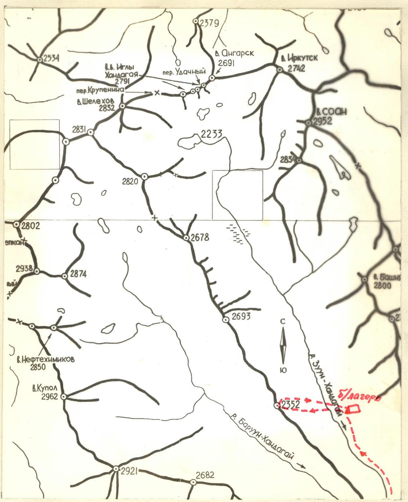
Map of the area
Description of the ascent route
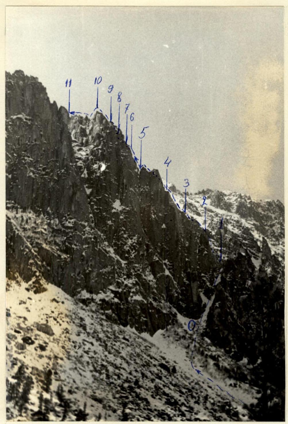
From the base camp, located at the forest boundary, the approach to the route crosses the Zuun-Khandagai river. The approach from the base camp to the start of the route takes 0.5 hours.
The route begins from a snow couloir leading to a saddle on a counterfort. The couloir approaches the counterfort from the south, its length is four ropes (R0–R1), the last rope is on an ice slope, exit to the saddle. Insurance is simultaneous and alternate, using pitons.
Further, the route passes on the right side of the counterfort, sometimes leading to the ridge. 15-meter inner corner (50°). The last 5 m are complex climbing, and then 20 m of ruined easy rocks (R1–R2). Insurance is piton.
Exit to the right under the system of inner corners, along them 60 m under the red "beak" (R2–R3). The steepness of the section is 60–65°. Insurance is piton.
Then 5 m to the right behind the bend. Inner corner 45°, 20 m long. Exit to the ridge of the counterfort. To the right on a shelf is a control cairn. 60 m along the scree easy rocks. Exit under the first pillar (R3–R4). Insurance is piton.
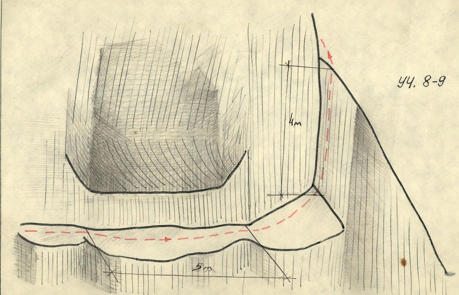
2-meter cornice, passed with the help of a ladder. On the cornice, there are loose rocks. Further, snow-covered slabs 40 m. Exit to the ridge. A gap in the inner corner 85°, 5 m. Then 30 m of easy rocks along the ridge. 5-meter drop (R4–R5). Insurance is piton.
Inner corner 70°, 20 m long, with loose rocks on top. Scree mulda 20 m. 10-meter inner corner 45° with a plug at the top (R5–R6). Insurance is piton.
From the plug to the right, two ropes of oblique, not clearly defined shelves (R6–R7). Insurance is through ledges.
At the top, a finger is visible, bypassing the finger to the right. Inner corner 20 m. The lower 3 m are steepness 90°, passed with the help of a ladder (R7–R8). Insurance is piton.
To the right along the shelf, traverse crawling under the cornice 5 m. 4-meter mirror on the right wall of the inner corner, steepness 85°. Insurance is piton. 10 m of easy rocks. Exit to the ridge. 40 m bypassing the ridge to the right. Exit under the pillar (R8–R9). Insurance is piton.
15 m steepness 80°, complex climbing. Insurance is piton (R9–R10).
Exit to the pillar. Descent by climbing simultaneously 20 m under the summit tower (R10–R11).
Further, 3 ropes of simultaneous movement traverse, crossing the snow couloir to the right along the path. Exit to the summit ridge (R11–R12).
From here, 60 m of rocks of medium difficulty. Insurance is piton. 10 m traverse to the right, 20-meter inner corner 50° with a plug. Bypassing the plug to the left. Ladder (R12–R13).
Exit to the ridge. 15 m traverse to the left from the ridge and up under the 20-meter chimney with plugs (R13–R14). Insurance is piton. Exit to the summit ridge.
Further, 150 m of simultaneous movement along the ridge and easy rocks to the summit.
Summit. Descent from the summit along the ruined ridge and snow couloir north of the summit. The couloir ends with a wide scree cone, at the foot of which flows the Zuun-Khandagai river.
Base camp. The group left the base camp at 7:00, approached the route in half an hour, was at the control cairn at 11:00, reached the summit at 19:30, and returned to the base camp at 21:00. A total of 27 pitons were hammered on the route.
According to the difficulty, length, and weather conditions of the ascent, the group evaluates the route along the Eastern counterfort as a 4A category route.
Group leader A. Afanasiev.
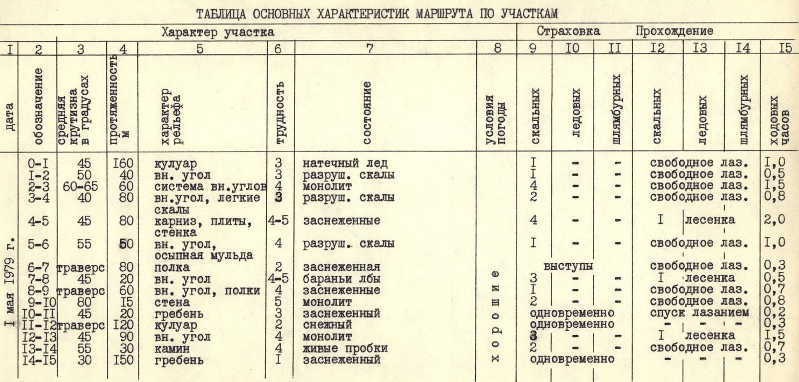
Table of main characteristics of the route by sections
Route profile
Photo 2