Passport
I. Class of ascent — rock.
2. Region of ascent, ridge — Tunkinskie Goltsy, Zuun-Khandagai and Baruun-Khandagai gorges.
3. Peak, its height, ascent route — p. Dinosaur, 2820 m, via the northwestern ridge with ascent along the left western counterfort.
4. Proposed category of difficulty — 4A category.
5. Characteristics of the route:
height difference — 450 m; average steepness — 38°; length of sections:
2 — 400 m,
3 — 220 m,
4 — 270 m.
6. Number of pitons for belay — 15 pcs.
7. Number of walking hours — 9 hours.
8. No overnight stays.
9. Leader: Gnoevsky I. P. — CMS,
participant: Nikonov V. P. — CMS,
participant: Yushkevich V. I. — CMS,
participant: Stanevich A. M. — CMS.
10. Team coach — Petrashko G. A.
11. Date of departure and return from the route — May 4, 1981.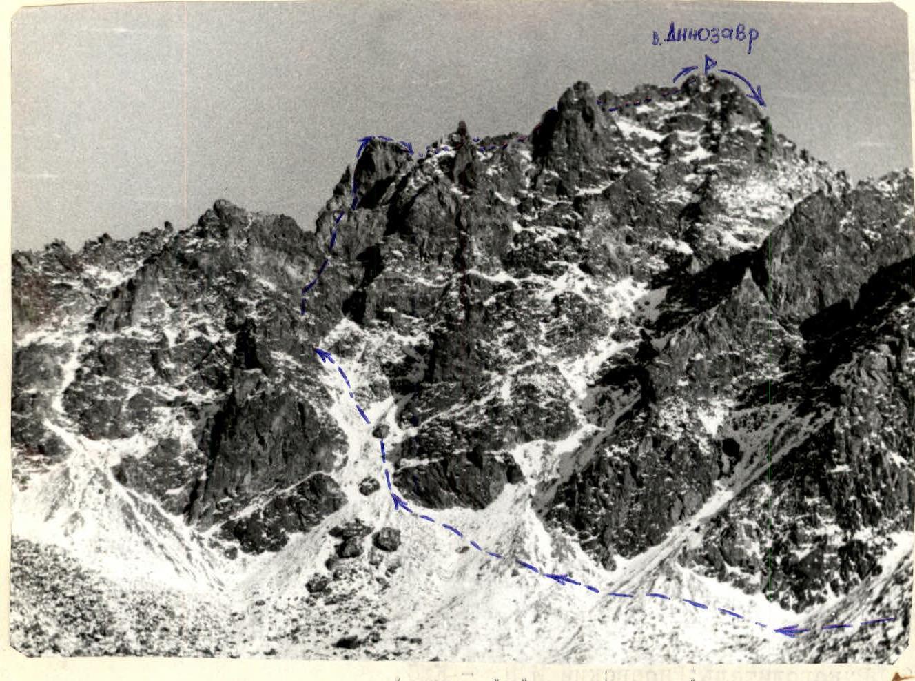
Table of main characteristics of the first ascent to p. Dinosaur
| Date | Average steepness, ° | Designation | Length, m | Character of relief | Difficulty (category) | Condition | Weather conditions | Pitons (rock) |
|---|---|---|---|---|---|---|---|---|
| May 4, 1981 | 35 | R0–R1 | 400 | Snow couloir | 2 (simultaneous movement) | Satisfactory | Good | - |
| 60 | R1–R2 | 120 | Destroyed rocks, walls | 4 (alternate belay) | Good | Good | 6 | |
| 0 | R2–R3 | 120 | Narrow ridge | 3 (alternate belay) | Good | Good | 1 | |
| 50 | R3–R4 | 150 | Snow couloir, inner angle, ridge | 4 (simultaneous, alternate) | Satisfactory | Good | 4 | |
| 30 | R4–R5 | 100 | Steep, destroyed rocks, ridge | 3 (simultaneous, alternate) | Satisfactory | Good | 4 |
Brief description of the approach to the route and explanation of the table (to p. Dinosaur via the northwestern ridge with ascent along the left western counterfort)
The route starts from the Baruun-Khandagai gorge. From the base camp to the Dinosaur pass — 3 hours. From the Dinosaur pass to the start of the route — 1.5 hours of walking.
Enter the 3rd large couloir (on the right as you go), ending in a cirque.
Climb to the top of the cirque and exit left onto the counterfort shoulder.
Control tour.
One rope to the left — bypass the wall with a spalled stone, then up to the right along an oblique ledge and up the wall head-on (12 m 65°) under the overhanging wall. Then up to the right along the wall — exit to the main ridge to the left of the rusty gendarme (40 m 60°). Bypass the gendarme on the left up steep destroyed rocks. Then 3 ropes of horizontal narrow knife-like ridge and descent to the saddle 15 m.
Here, in the saddle of the ridge, a hole is visible on the right under a huge stone. Descent into the hole to the left side along the couloir — 1 rope, then straight up, sticking to the right side of the couloir — 2 ropes of simultaneous movement. Exit to the right — 1 rope to the main ridge. Go to the right, bypassing the gendarme — 2 ropes. Then along the narrow knife-like ridge to the wall, which is bypassed on the left to exit to the main ridge — 60 m of difficult climbing on snowy destroyed rocks. Then 60 m — exit to the summit.
Descent via route 2B category of difficulty along the southern ridge.
Leader: Gnoevsky I. P. — CMS, Nikonov V. P. — CMS, Yushkevich V. I. — CMS, Stanevich A. M. — CMS.
The route corresponds to 4A category of difficulty.