Irkutsk
Regional Alpine Federation
Protocol №–304 from 6.71 г. To first ascenders.
Description
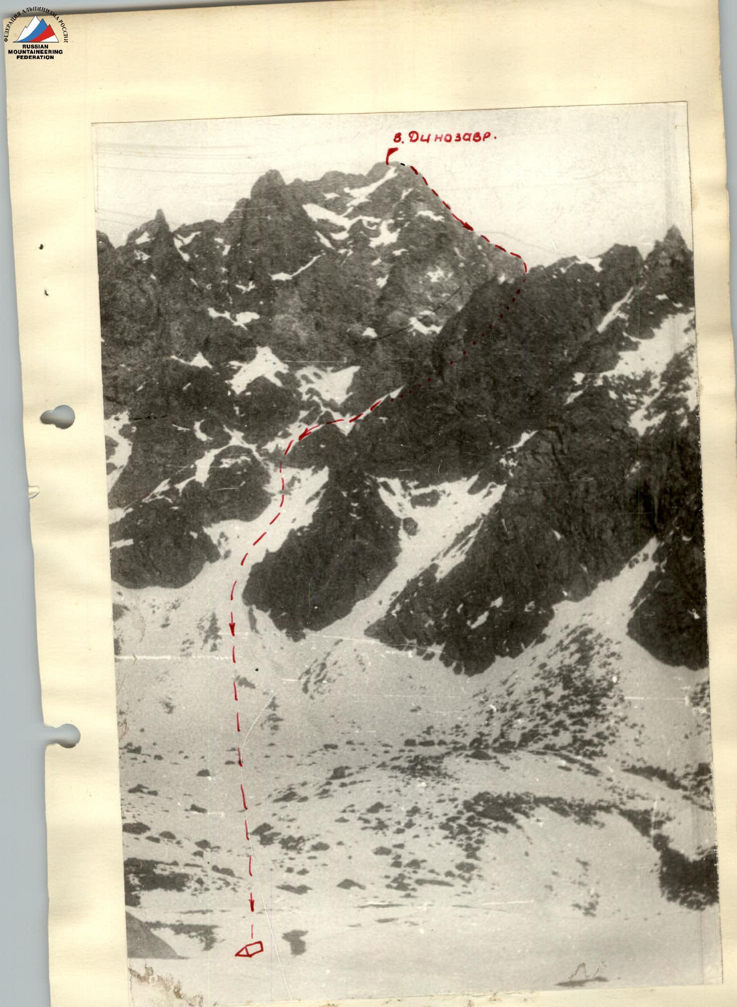
Ascent to v. Dinosaur (Tunkin Alps). via the eastern ridge (EASTERN SAYAN) Angarsk, 1971 г.
Geographical location, sporting characteristics, and history of exploration of the Zuun-Khandagai valley
The Zuun-Khandagai valley is located in the central part of the Tunkin Alps in the Eastern Sayan. The Dinosaur peak is situated somewhat to the left of the Tunkin Alps' watershed ridge, which closes the Zuun-Khandagai valley. Although the peak heights in the area do not exceed 3000 m, exploration is significantly hampered by complex climatic conditions and alpine landforms.
In 1969, this valley was explored by an expedition from the USSR Alpine Federation led by V. Abalakov.
In the same summer, a group of climbers from Irkutsk led by V. Belousov completed a first ascent of the southern wall of the SOAN peak and classified the route in summer conditions as 4B category of difficulty. They also classified a route via the southeast edge to the same peak as 2B category of difficulty. In May 1971, a combined team from Angarsk completed a first traverse of the Igly Khandagaya peaks, estimated at approximately 4B–5A category of difficulty.
It should be noted that winter conditions in the Eastern Sayan often persist until the end of May, when prolonged snowstorms and frosts unexpectedly thwart climbers' efforts. By the end of summer, the snow cover almost completely disappears. The area has over ten peaks of interest to climbers, and only the SOAN peak currently has classified routes.
The first attempt – twice unsuccessful – to conquer the Dinosaur peak was made by the same group in a slightly altered composition in May 1971.
Conquering the Dinosaur peak is another attempt to classify the peaks in this interesting and promising area. From the base camp at the confluence of the left and right Zuun-Khandagai rivers to the start of the route is a 2–2.5 hour approach.
Route description
October 17, 1971
The route began at 9:00.
Section R0–R1 (photo 1, 2)
Ascent via a couloir to a ridge saddle. On the saddle, there's a control cairn.
Section R1–R2 (photo 3)
From the saddle, we traverse a destroyed section of the ridge along a slope with a 45° incline to the 2nd main pinnacle №1. The pinnacle is traversed on the left along the slope with a 60° incline, with small snowy ledges under the ridge ascent.
Section R2–R3 (photo 4)
The ascent is made alternately via destroyed rocks. Under the ascent peak, we traverse right along slabs to the 2nd pinnacle.
Section R3–R4 (photo 5, 6)
The 2nd pinnacle is bypassed on the right, upwards along snowy slabs to the wall on the ridge.
Section R4–R5 (photo 7, 8, 9, 10)
We ascend the wall (80°) directly. Climbing is very difficult. We pull up backpacks. After 30 m, we reach the top of the 3rd pinnacle. On the pinnacle top, there's a control cairn. Descent from the pinnacle via a vertical wall with a 40 m rappel to a ledge. Convenient overnight stop. We stopped for the night at 19:00. The first day's route took 10 hours.
October 18, 1971
In the morning, the weather worsened, with fog and snow approaching. One rope team (two climbers) went on reconnaissance and route preparation. After two hours, having fixed 70 m of rope, the team returned. We decided to continue. We started the route at 10:00.
Section R5–R6 (photo 11, 12, 13)
From the overnight stop, we ascend the wall of the 4th pinnacle (70°) and traverse left along the entire pinnacle via the wall (80°) made of snowy slabs. The section is difficult; we hammered in 6 pitons. We reach a "window" on the ridge under the Bый pinnacle.
Section R6–R7 (photo 14, 15)
We bypass the Bый pinnacle on the right along narrow rock ledges and ascend the wall (80°) to the pinnacle top. Climbing is complex; we hammered in 3 pitons. We pull up backpacks. From the pinnacle top, we descend using climbing techniques to a scree ledge.
Section R7–R8 (photo 17, 16)
We move simultaneously, bypassing the "tooth with a crack" on the left under the sub-summit. We ascend the wall (80°) to the sub-summit directly. Very complex climbing; we pull up backpacks. Further along a narrow, gentle, heavily destroyed ridge, we reach the summit. The second day's route took 8 hours.
Section R8–R9 (photo 18)
Descent from the summit via the southwest ridge (45°) using climbing techniques to a saddle. From there, we descend via a wide couloir (30°) to the Barun-Khandagai valley. The descent from the summit to the overnight stop took 3 hours. Overnight stop.
October 19, 1971
The transition through the pass to the Zuun-Khandagai valley to the base camp took 4 hours.
Route and team assessment
This route requires good rock climbing skills. Throughout the route, there are many complex sections, including several wall sections with difficult climbing on small holds. To overcome these, a wide range of pitons, especially angled ones, is necessary.
The route's complexity increases significantly in the presence of abundant snow. It should be noted that literally after section R2–R3, there are practically no more or less simple emergency descents on the route. All descents must be carried out mainly by organizing rappels down wall couloirs.
The group is a cohesive team with previous routes of 4B and 4A category of difficulty. According to the group's consensus, the route in the given conditions corresponds to 4A category of difficulty.
Group composition:
- Nikolaeva I.M. – II sports category + 4A + 4B – leader.
- Putilov Yu.P. – II sports category + 4A + 4A – participant.
- Zarechnyuk I.P. – II sports category + 4A + 4A – participant.
- Zubova V.Ya. – II sports category + 4A + 4A – participant.
- Sazanov V.V. – II sports category + 4A + 4A – participant.
Leader /I. Nikolaeva/
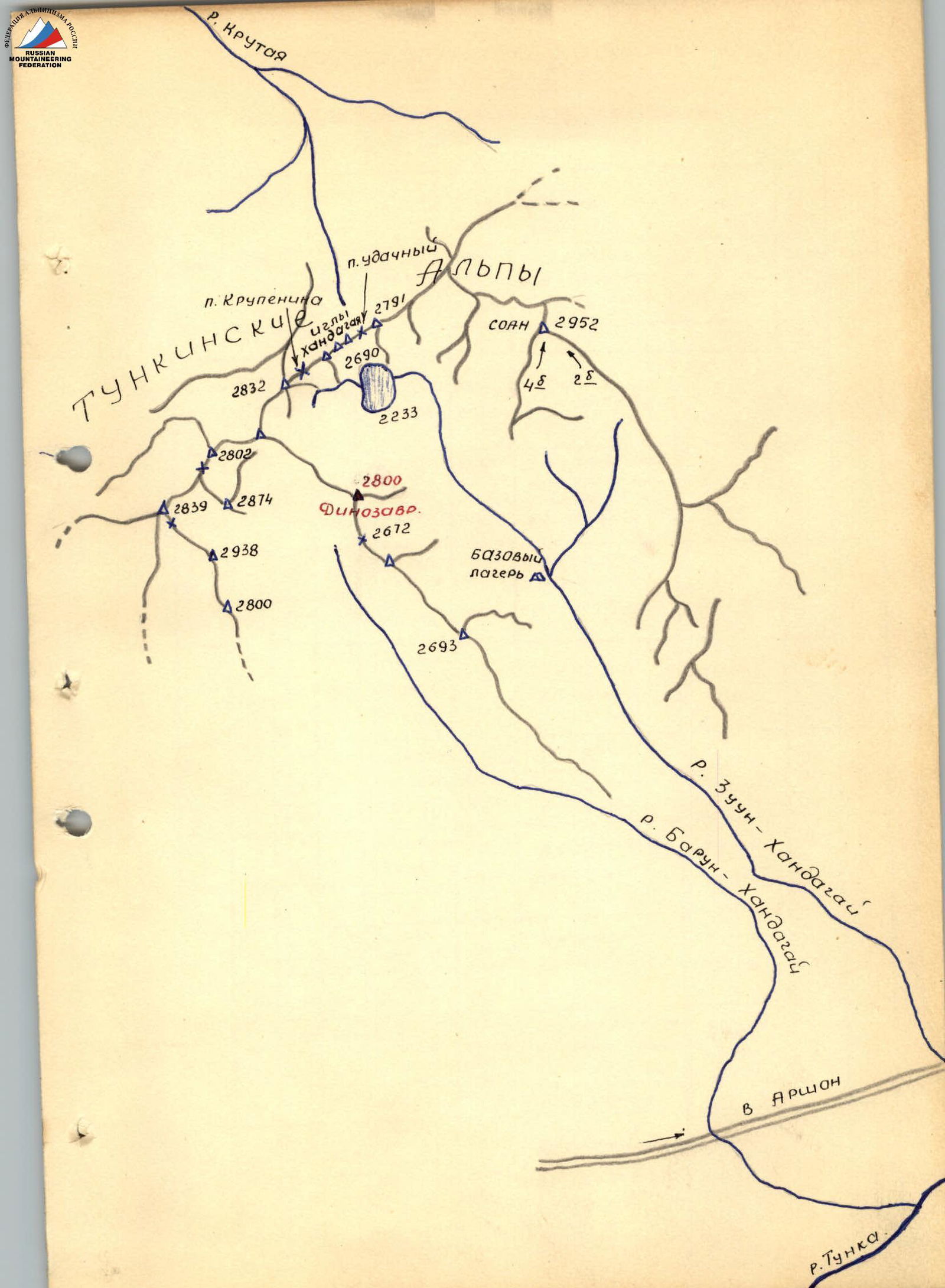

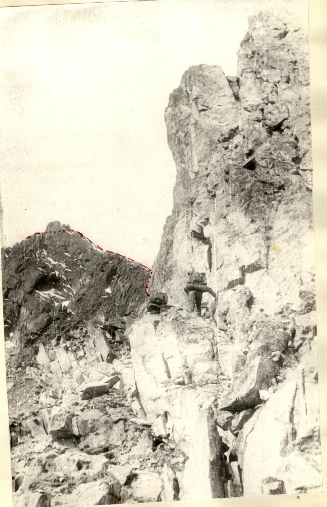
Photo 3
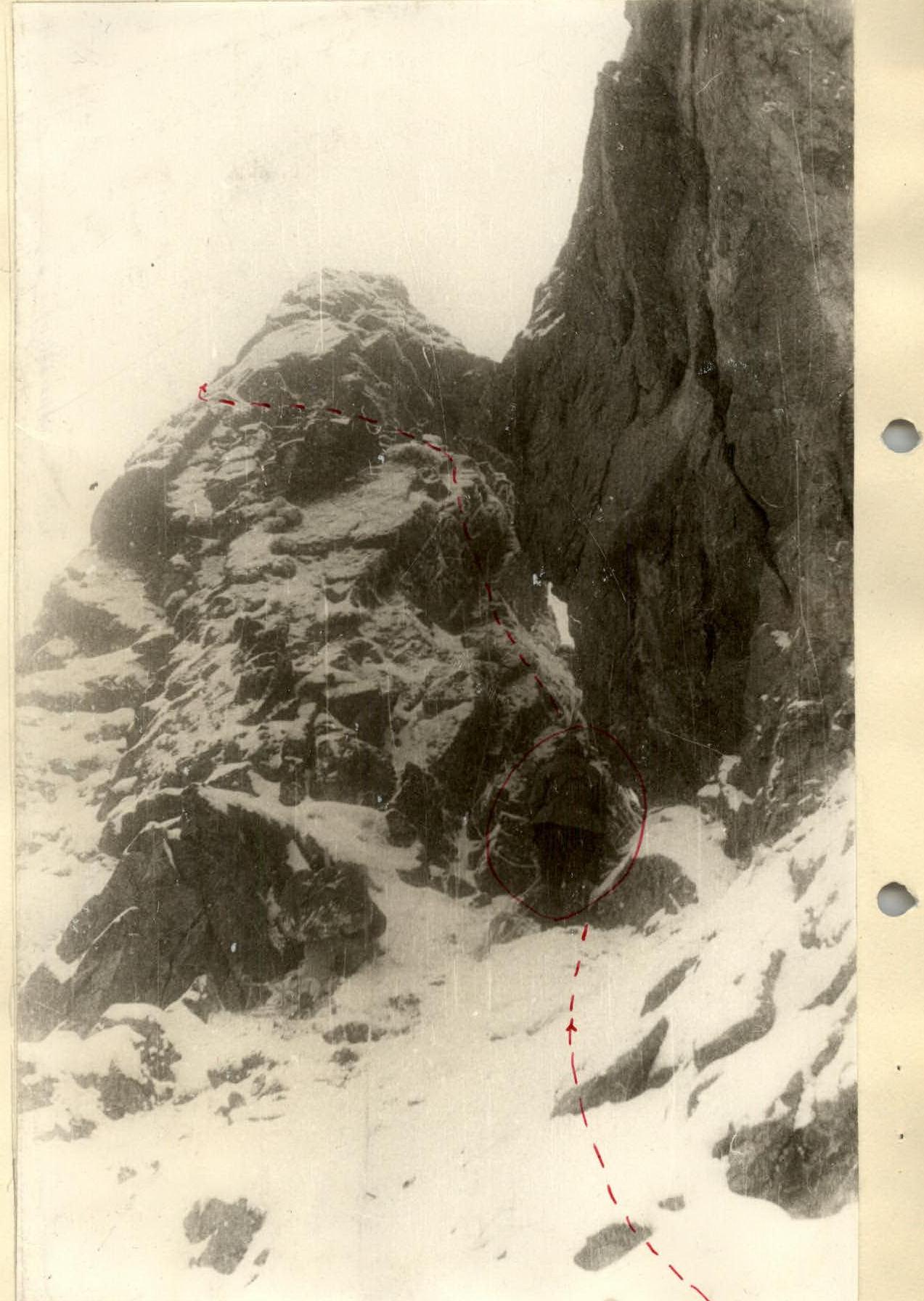
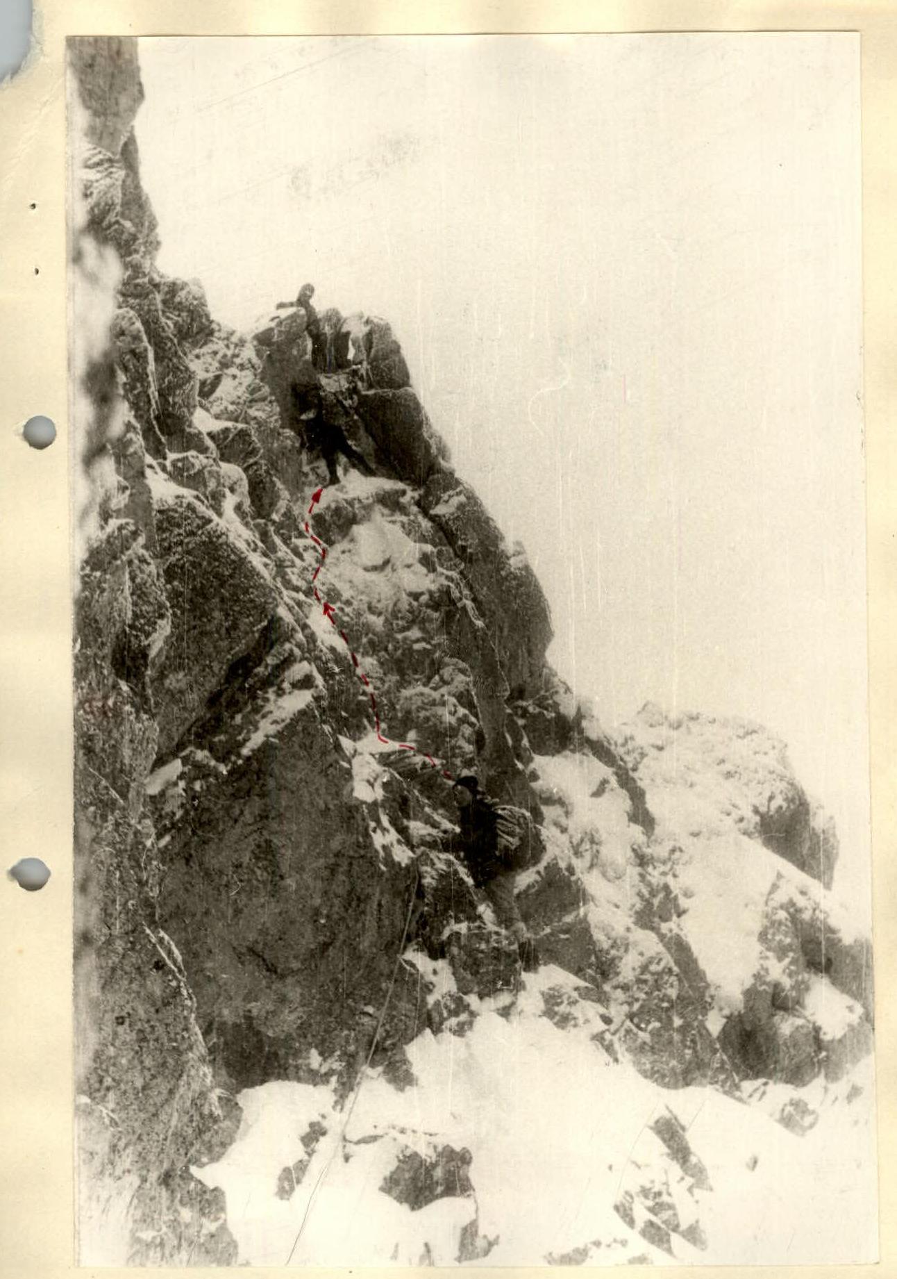
Photo 14