The summit of Bronenosets (about 2450 m) Tunkinskie Goltsy, Eastern Sayan
The summit is located in the upper reaches of the Levaya Kyngarga River. The Kyngarga River gorge has already been explored for mountaineering. Routes ranging from 1B to 4B difficulty category have been laid out to the peaks of this area. One of the last uncharted peaks for climbers was the Bronenosets summit.
The first ascent via the North (Central) ridge was made during the Irkutsk regional alpinade on May 10, 1976, by a group consisting of:
(see general view)
Alpinade leader MS - T. V. Trubnikova Detachment commander - V. P. Bryanskogo - 1st sports category.
Participants:
- G. A. Moskalev - CMS
- A. S. Kodachikov - CMS
- V. P. Nikonov - 2nd sports category
- A. F. Cheremnykh - 2nd sports category
- E. A. Frizen - 2nd sports category
- Yu. P. Drinskiy - 2nd sports category
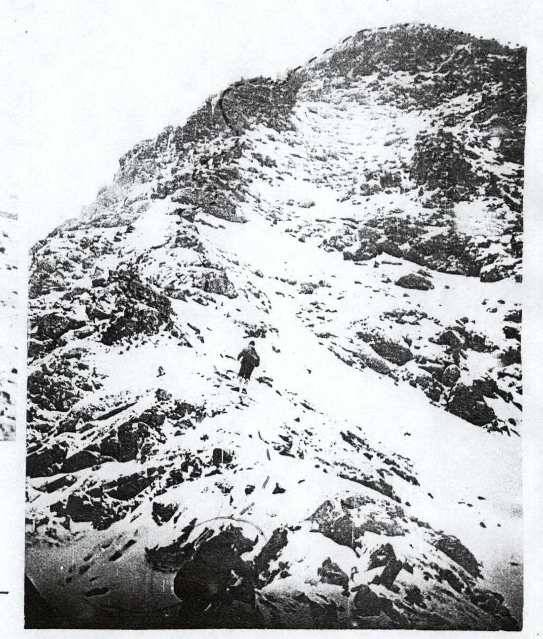
From the base camp on the Kyngarga River to the tributary of the Levaya Kyngarga River along its right bank to the North ridge (about 2 hours). The ascent to the ridge does not present technical difficulties (see photo 1 and 2).
Section R1
A wide rocky ridge is traversed with simultaneous insurance on the right (rocky drop-offs on the left). Gradually, the ridge becomes narrow, insurance is provided through ledges.
Section R2
Ascent to a narrow isthmus before the rocky wall (photo 3, 4).
Rocky wall:
- Height: 20–25 m
- Steepness: 50–60°
- Rocks of medium difficulty (3)
- Piton belay
Loose rocks are possible! It's better to set up a rope barrier.
Overcoming this section takes 1–1.65 hours.
The wall gradually becomes less steep and turns into a heavily jagged rocky ridge. Movement is done with simultaneous and alternating insurance (photo 5, 6).
Section R3
A narrow ridge leads to an ascent. Rocks are of medium difficulty, with good holds, insurance through ledges. The section is 40 m long. Difficulty 2–3.
The ascent ends with a steep rocky ridge leading to a pre-summit snow plateau. Insurance is simultaneous and alternating through ledges (Photo 7, 8, 9).
The ascent to the summit across the snow plateau is not technically difficult, movement is simultaneous. The descent from the summit along the eastern ridge to the pass is not difficult (1B category). (Photo 10) It takes about 3 hours to reach the base camp. The ascent took the first ascenders 10 hours. Departure from the base camp was at 5:30, return at 15:30. The ridge route is logical and clearly visible during the approach.
Recommendations of the ascent participants
1: On sections II and III, when passing with two detachments, it's better to set up a rope barrier.
- On section II, loose rocks are possible!
2: In the Sayan Mountains with unstable weather in May, it's recommended to carefully observe the descent path from the summit when ascending to the pre-summit plateau.
Equipment for a group of 6 people
- Main ropes — 3 pcs. (40 m)
- Rock pitons — 3–4 pcs.
- Hammers — 2 pcs.
The group evaluates the route as a combined 2A category. In the following 3 days, 4 more sports groups made ascents, also evaluating the route as 2A category and emphasizing that it's even somewhat more difficult than the training routes of 2A category in the T algar, Dugoba, and Ala-Archa alpinist camps.
The ascent analysis was conducted in the presence of a representative of the USSR Alpinism Federation MS L. A. Aleksashin.
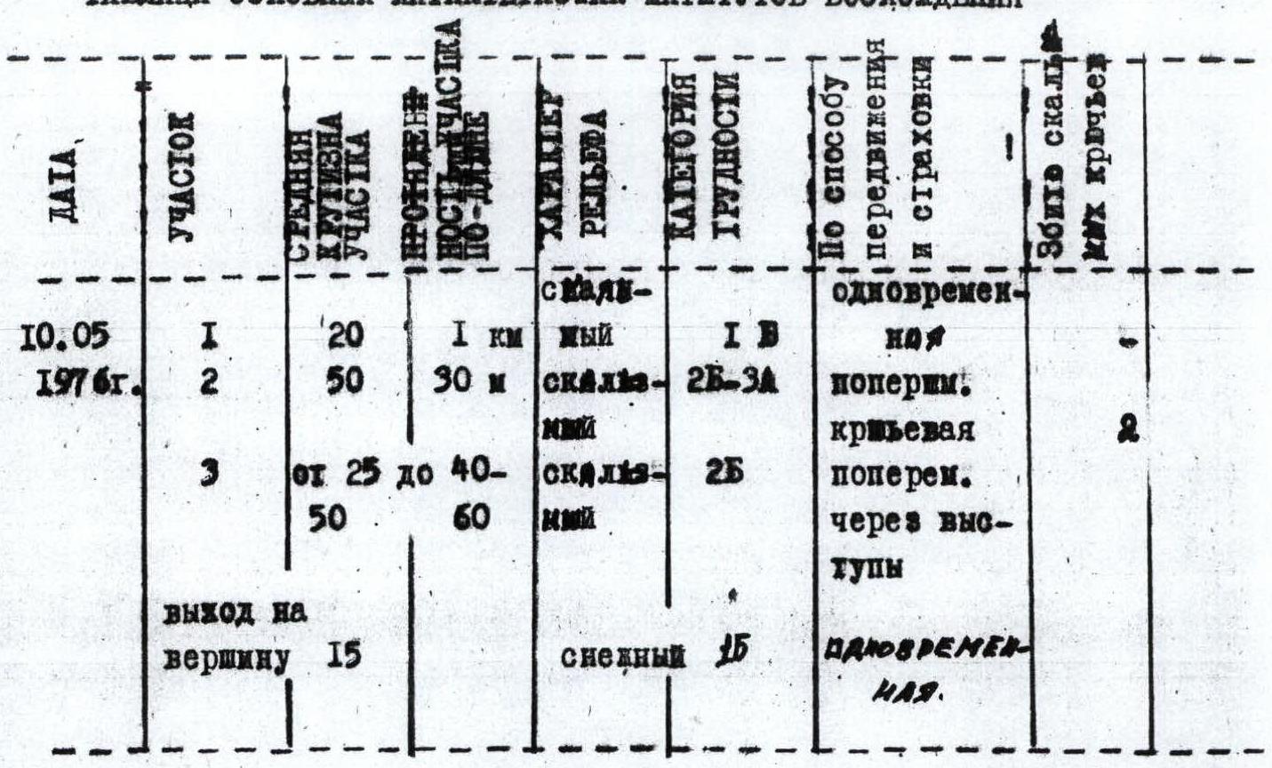
TABLE OF MAIN CHARACTERISTICS OF ASCENT ROUTES
| DATE | SECTION | SECTION LENGTH (m) | DISTANCE (m) | TERRAIN TYPE | DIFFICULTY | INSURANCE METHOD | PITONS DRIVEN |
|---|---|---|---|---|---|---|---|
| May 10, 1976 | 1 | 20 | 1000 | rocky | 1B | simultaneous | |
| 2 | 50 | 30 | rocky | 2B–3A | alternating, piton belay | 2 | |
| 3 | 25–50 | 40–60 | rocky | 2B | alternating through ledges | ||
| Summit ascent | 15 | snowy | 1B | simultaneous |