Arshan (3)
DESCRIPTION OF THE ASCENT TO THE "BRONENOSETS" PEAK VIA ROUTE 2B CAT. DIFF.
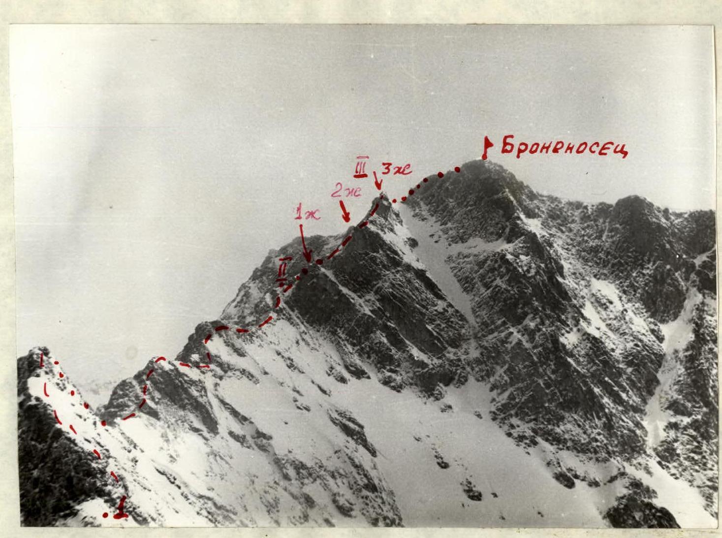
The "Bronenosets" peak is located in the upper reaches of the Levaya Kyngarga River (Tunkinskie Goltsy; Eastern Sayan Mountains). Its height is approximately 2,450 meters above sea level. It is the last unclimbed peak in the area, due to its remoteness. The group made the first ascent of the route on May 9, 1976.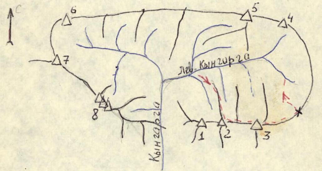
- "Druzhba" peak
- "Arshan" peak
- "Bronenosets" peak
- "Piramida" peak
- "Obzorny" peak
- "Bratchanка" peak
- "9 Maya" peak
- "Trehglavaya" peak
Section 1
From the base camp, along the right (orographic) bank of the first left tributary of the L. Kyngarga River - ascent along the Northern ridge of the Arshan peak (photo 1). The ascent does not present technical difficulties. In the upper part, there is 1 gendarme that is bypassed on the right along a characteristic "tooth" (photo 2). The exit to the ridge leading to the "Bronenosets" peak is between the 1st and 2nd gendarmes of the Arshan peak. The journey takes 3-4 hours from the base camp.
Section 2 (photo 3)
Connect on the saddle. The path along the ridge leading from the Arshan peak to the "Bronenosets" peak is logical. Difficulty is 2A cat. diff. Small gendarmes are overcome with simultaneous or alternate belay (photos 4, 5). Time taken to complete this section is 1-1.5 hours.
Section 3. The first gendarme of the pre-summit ridge of the "Bronenosets" peak is bypassed on the left along snowy slabs (photos 3 and 6). The second gendarme is overcome "head-on". The ascent consists of two sections, each 10-15 meters long and with a slope of about 60° (photos 7, 8). Between the sections, on a wide ledge, it is necessary to organize belay. Ropes are desirable. Difficulty is 2B cat. diff. The third gendarme is bypassed on the left along slabs, exiting onto the summit of the gendarme (photos 9, 3). The length of the difficult section is 30 meters. Difficulty: 2B-3A. The passage of this section takes 1.5 hours. From the third gendarme, there is a straightforward ascent to the summit (15-20 minutes). From the summit, descend along the straightforward, wide eastern ridge to the saddle, and then along the L. Kyngarga River to the base camp (photo 1). The journey from the summit to the base camp takes about three hours.
Recommendations for climbers: When descending, beware of small avalanches from the right side of the L. Kyngarga River valley.
Equipment for a group of 6 people:
- ropes 3/40
- rock pitons 3-4 pcs.
- hammers (ice axes) 2 pcs.
Composition of the group that made the ascent:
- Adov V.G. - CMS
- Pologrudov V.V. - CMS
- Filippova T.M. - 1st sports category
- Nemirovsky Yu.B. - 1st sports category
- Ponamarchuk V.S. - 1st sports category
- Stanevich A.M. - 1st sports category
The group evaluates the route in these conditions as rock climbing 2B cat. diff. The next day, the route was repeated by a training group under the guidance of CMS Yanochkin R. (Moscow), which also rated the route as 2B cat. diff. A representative of the USSR Alpine Federation, MS Aleksashin L.V. (Moscow), was present at the debriefing.
Table of main characteristics of the ascent route
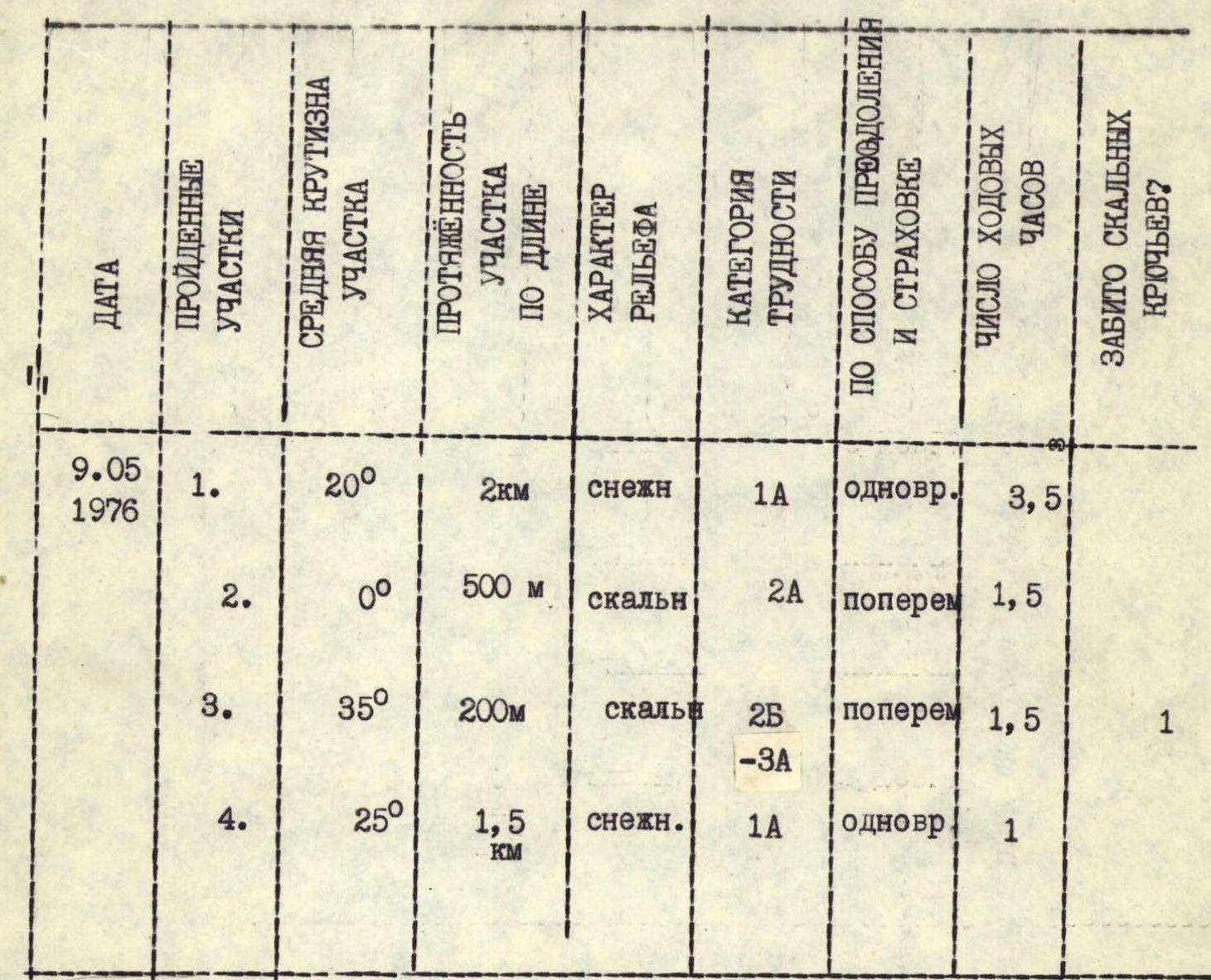

Photo #2