Bronenosets (about 2450 m) Tunkinskie Goltsy, Eastern Sayan
The summit is located in the upper reaches of the Levaya Kyngarga River. The Kyngarga River gorge has already been explored for alpinism. The peaks in this area have routes ranging from 1B to 4B category of difficulty. One of the last uncharted peaks for climbers was the Bronenosets peak.
The first ascent via the North (Central) ridge was made during the Irkutsk Regional Alpinade on May 10, 1976, by a group consisting of:
(see general view, photo)
Head of the Alpinade MS — T.V. Trubnikova Detachment Commander — V.P. Bryansky — 1st sports category
Members:
- G.A. Moskalev — CMS
- A.S. Kodachikova — CMS
- V.P. Nikonov — 2nd sports category
- A.F. Cheremnykh — 2nd sports category
- E.A. Frizen — 2nd sports category
- Yu.P. Yurinsky — 2nd sports category
From the base camp on the Kyngarga River to the tributary of the Levaya Kyngarga River along its right bank to the North ridge (about 2 hours). The ascent to the ridge does not present technical difficulties (photo 1 and 2).
R1
A wide rocky ridge was traversed with simultaneous belay on the right (to the left are rock falls). Gradually, the ridge narrows, and belay is done through outcrops.
R2
Ascent to a narrow saddle before a rocky wall (photo 3, 4). The rocky wall is 20–25 m high with a steepness of 50–60°. The rocks are moderately difficult (3A category of difficulty). Piton belay is used. Live rocks are possible! It's better to set up a rope. The passage takes 1–1.5 hours. The wall gradually becomes less steep and transitions into a heavily jagged rocky ridge. Movement is done with simultaneous and alternate belay (photo 5, 6).
R3
A narrow ridge leads to an ascent. The rocks are moderately difficult with good holds, and belay is done through outcrops. The length of this section is 40 m. The difficulty is 2B–3A category.
The ascent ends with a steep rocky ridge leading to a pre-summit snow plateau. Belay is simultaneous and alternate through outcrops (photo 7, 8, 9).
The ascent to the summit via the snow plateau is not technically difficult; movement is simultaneous. The descent from the summit along the eastern ridge to the pass is not difficult (1B category of difficulty) (photo 10). To the base camp is about 3 hours. The ascent took the first ascenders 10 hours. Departure from the base camp was at 5:30, return at 15:30. The route is ridge-like, logical, and clearly visible on the approach.
RECOMMENDATIONS FOR CLIMBERS
- On sections R1 and R3, when traversed by two groups, it's better to set up a rope.
- On section R2, live rocks are possible!
- In the Sayan Mountains with unstable weather in May, it's recommended to carefully examine the descent route from the summit when reaching the pre-summit plateau.
EQUIPMENT FOR A 6-PERSON GROUP
- Main ropes — 3 pcs. (40 m)
- Rock pitons — 3–4 pcs.
- Hammers — 2 pcs.
The group rates the route as a combined 2A category of difficulty. Over the next 3 days, 4 more sports groups ascended, also rating the route as 2nd category of difficulty and noting it was somewhat more challenging than training routes of the 2nd category of difficulty in alpinist camps:
- "Talgar"
- "Dugoba"
- "Ala-Archa"
The ascent review was conducted in the presence of a representative from the USSR Alpinism Federation, CMS L.A. Aleksashin.
Table of Main Characteristics of Ascent Routes

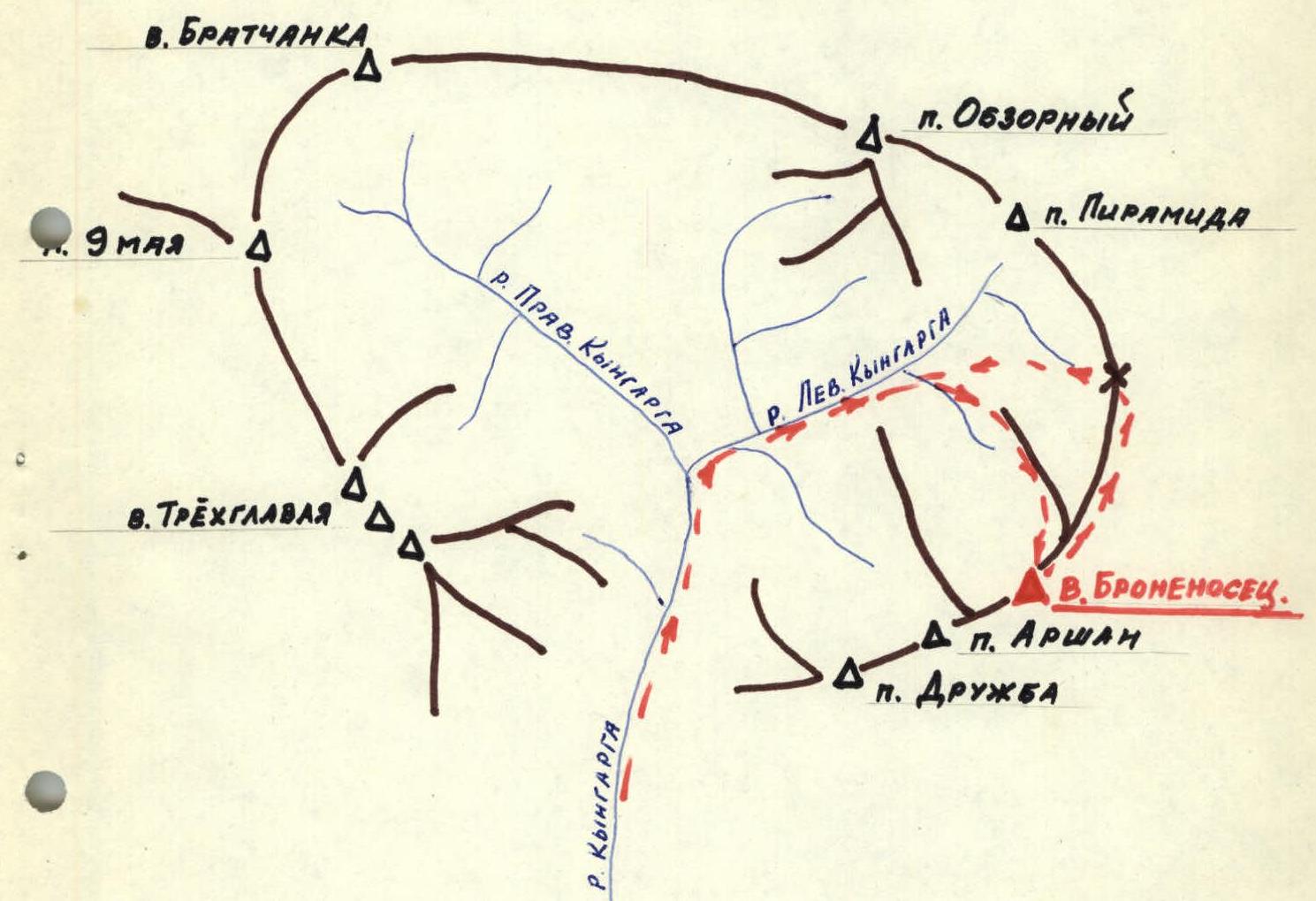
Orographic Scheme
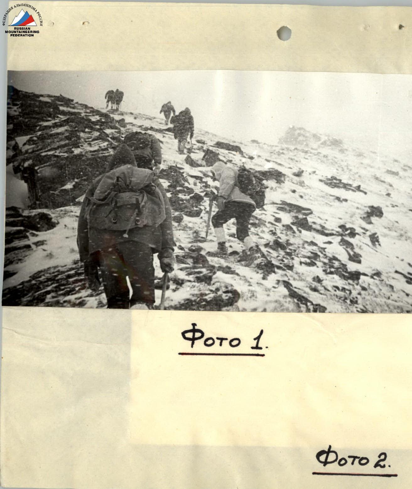
Photo 1.
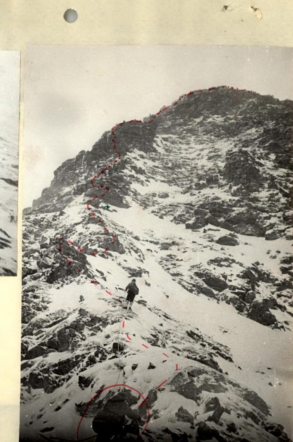
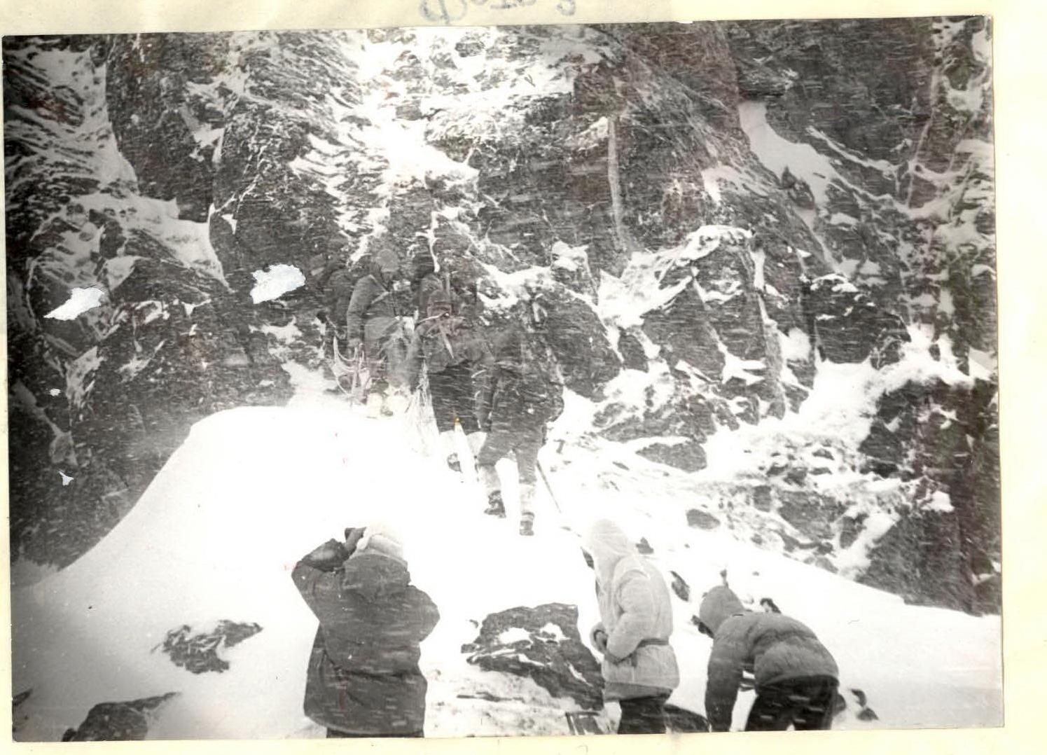
Photo 3.

R0–R1, R1–R2, R2–R3 — route sections — small twigs.
Irkutsk Regional Alpinism Federation
Description of the Ascent to the "Arshan" Peak via the North Ridge
(Tunkinskie Goltsy, Eastern Sayan, 2546 m)
Irkutsk, 1971
Geographical Background, Sports Characteristics, and History of Exploration of the Kyngarga Gorge
Tunkinskie Goltsy is the highest ridge in the Eastern Sayan. The highest point is 3266 m in the upper reaches of the Ganga-Khairym gorge. The ridge has alpine relief forms. There are many peaks of interest to climbers.
The gorges are deep, covered with dense taiga. The forest boundary lies at an altitude of 1700 m. The snow cover almost completely disappears by the end of summer. There is no glaciation.
The "Arshan" peak is located in the upper reaches of the Kyngarga River gorge. This gorge is the closest to the roads, making it the most accessible, popular, and explored. Many routes have been laid to the peaks in this area, with 6 of them being classified. Regional alpinades are held here annually. Despite this, there are still opportunities for new routes.
From the resort to the base camp is a 4-hour ascent up the gorge. The height of "Arshan" peak is 2546 m (photo 1, 2).
Route Description
From the base camp at the confluence of the rivers (1202 m), ascend along the Levaya Kyngarga River, then right onto a forested spur (photo 1, 2). From the forest boundary, follow the ridge (photo 4, 5) to the rocks. Ascend to the first pillar, along the ridge, bypassing rocks on the left, with alternate belay (photo 6, 7). Then, along a snowy slope, not reaching the top of the pillar, pass through a window between the "tooth" (photo 8, 9). Descend to a saddle. Then, ascend to the 2nd pillar, in the lower part, bypassing rocks on the right (photo 10), then "head-on," with some complex sections having ropes (photo 11, 12, 13).
Descend to a saddle with alternate belay (photo 14, 15). The next rocky ascent to the next saddle is bypassed on the right. Ascend to the 3rd pillar along a wide ridge (photo 16, 17, 18), with simultaneous and alternate belay. Upon reaching the rocky wall of the 4th pillar:
- descend along the rocky wall (ropes or a sports piton, photo 19);
- along a wide ledge, bypass the pillar and ascend to the ridge (photo 19);
- move along the ridge with alternate belay, taking small pillars "head-on" (photo 20, 22) or bypassing them (photo 21).
In the upper part, the ridge turns right and leads to the summit (photo 23, 24). Descend via the ascent route.
The entire route from camp to camp takes 11–12 hours, and for training groups, up to 14 hours.
The route has been traversed multiple times and rated by all groups as 2A category of difficulty.
This description was compiled by alpinism instructor V.P. Bryansky — 1st sports category, who ascended with a group of badge holders. I confirm the difficulty category.
Table of Main Characteristics of "Arshan" Peak, 2A Category of Difficulty
| Date | Section | Steepness | Length in m | Character of Relief | Tech. Difficulty | Method of Overcoming and Belay | Weather Conditions | Time Taken | Rock Pitons |
|---|---|---|---|---|---|---|---|---|---|
| 29.10.1971 | R0–R1 | 25° | 2250 m | wide ridge | 1A | simultaneous | cloudy | 2.5 | – |
| R1–R2 | 30° | 180 m | rocks | 2A | simultaneous, alternate | wind | 0.5 | – | |
| R2–R3 | 25° | 300 m | rocks | 2A | alternate | wind | 0.5 | – | |
| R3–R4 | 35° | 200 m | rocks, slabs, wall | 2B | alternate | wind | 1 | 1 | |
| R4–R5 | 25° | 350 m | rocks | 2A | alternate | wind | 1 | – | |
| R5–R6 | 20° | 200 m | rocks | 2A | alternate | wind | 1 | – | |
| R6–R7 | 30° | 250 m | ridge, snowy boulders | 2A | alternate | strong wind | 1 | – | |
| Total Length: 3850 m | Total Time: 7.5 | Pitons: 1 |


Photo 1.
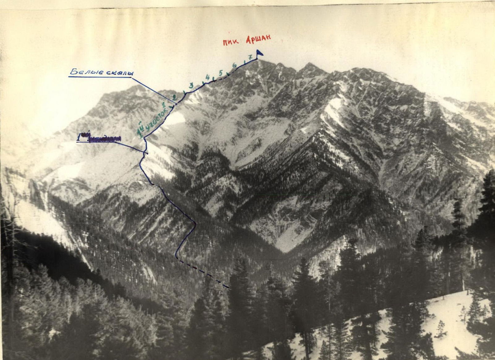
Photo 2.
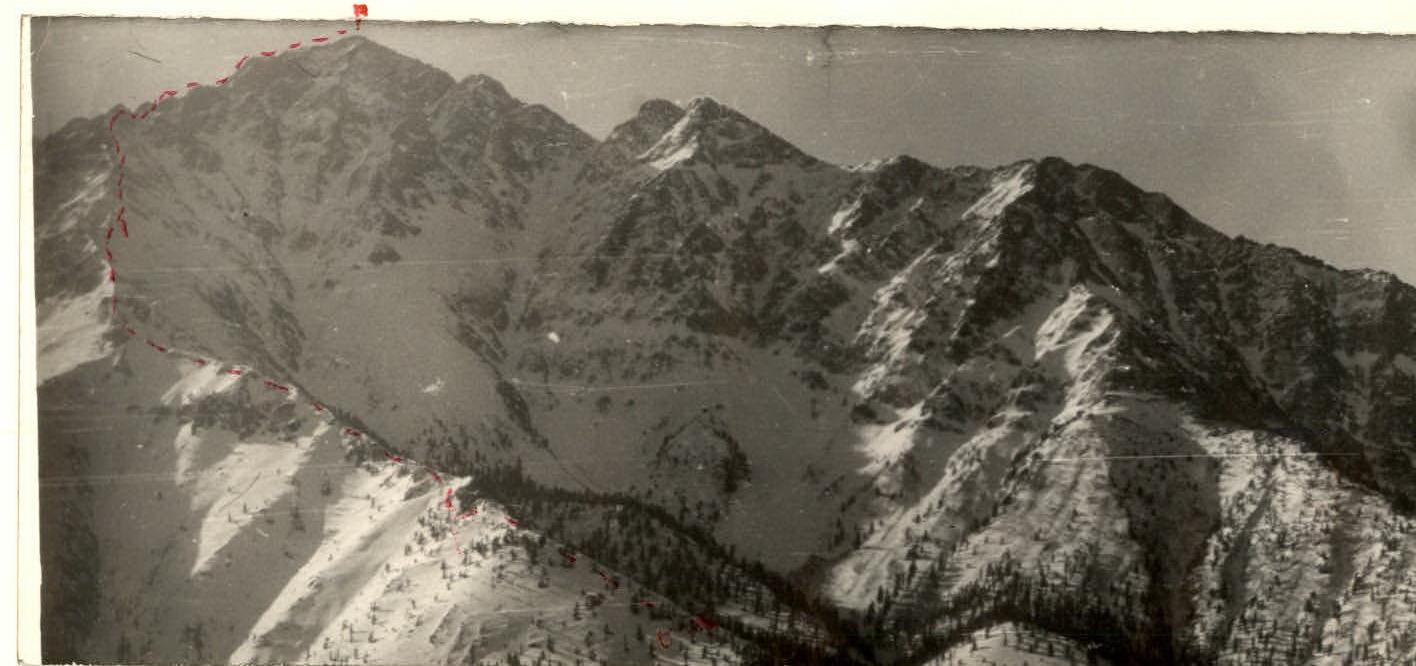
Photo 4.
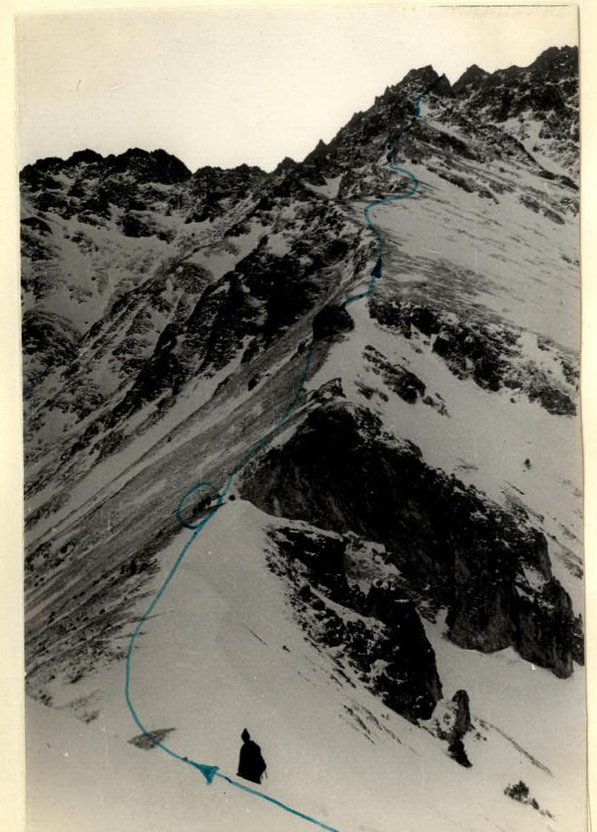
Photo 5.
