Ascent passport.
- East Sayan, Bolshoy Sayan ridge, Muguvek gorge, section 6.1.
- Trudnaya peak, 3185 m, via East counterfort.
- Proposed category: 5A, first ascent.
- Route type: combined.
- Height difference: 500 m,
- Route length: 675 m, average slope: 60°.
- Pitons used: rock and wired — 75 pcs.
East counterfort. 3. Proposed category: 5A, first ascent. 4. Route type: combined. 5. Height difference: 500 m,
length: 675 m, average slope: 60°. 6. Pitons used: rock and wired — 75 pcs.,
bolted — 3 pcs.
-
Team's travel time — 18 hours.
-
No overnight stays on the route.
-
Team:
- Afanasiev A.E. MS
Muravyev O.Yu. CMS Krivosheev K.P. 2nd sports rank
- Coach Afanasiev A.E. MS
- Route reconnaissance — August 6, 2009, ascent — August 7, 2009, descent — August 8, 2009.
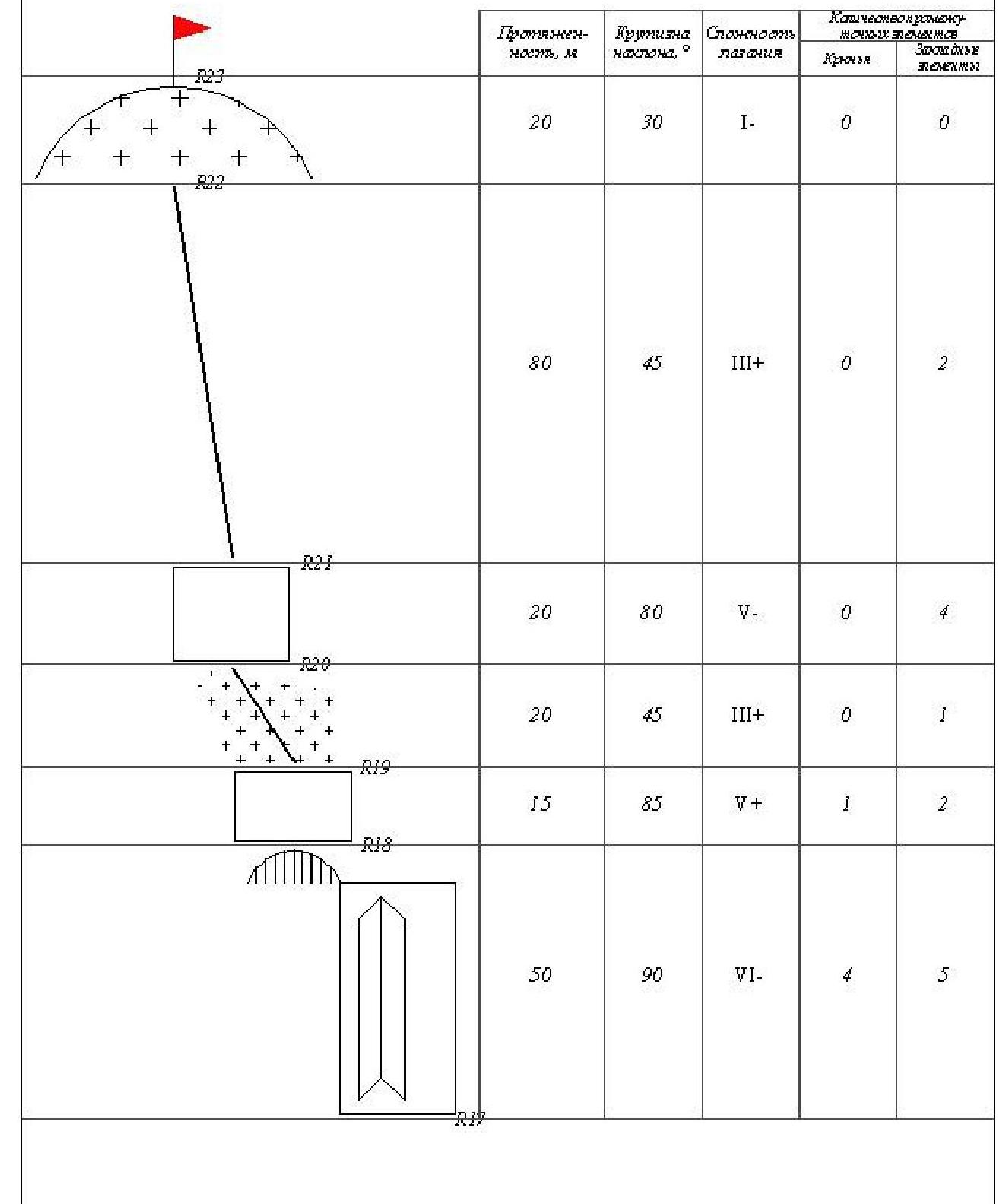
Description of the ascent route to Trudnaya peak 3185 m via Southeast counterfort, cat. 5A.
Approach to the route from the base camp at the forest boundary takes 2 hours 30 minutes.
The route can be started from the right of the ridge along a ledge or from the left — up the rope along a
ledge leading to the ridge of the counterfort. Sect. 0–1, 20 m, 80°, IV+, Inner corner to the right
of the ridge. Upper part has a rock plug and a slight overhang. Sect. 1–2, 40 m,
40°, III — System of inclined ledges along the ridge. Sect. 2–3, 45 m, 65°, IV — Slabs
to the left of the ridge. (If starting from the left along the ledge, this section becomes the first). Sect. 3–4, 35 m, 60°, III+ — System of slabs and grassy ledges. Sect.
4–5, 30 m, 55°, III — System of slabs and grassy ledges. Sect. 5–6, 10 m, 90°, V —
Rocky, icy gutter. Sect. 6–7, 15 m, 40°, I+ — Snowy couloir. Sect. 7–8, 20
m, 85°, V — Rocky wall. Sect. 8–9, 30 m, 65°, IV+ — Rocky gutter filled with
ice. Sect. 9–10, 20 m, 80°, V — Destroyed, rugged wall. Sect. 10–11, 30 m,
85°, V+ — Inclined chimney to the right. Left side overhangs. Key section of the lower bastion
of the route. Sect. 11–12, 20 m, 50°, III+ — Snow-ice couloir. Sect. 12–13, 30 m,
70°, V — Icy chimney. Passed on the left side. Sect. 13–14, 25 m, 50°,
III — Frozen, snowy, icy couloir. End of the section has a control cairn on a
bolted piton. Sect. 14–15, 50 m, 85°, V — Destroyed rocky wall. Exit to the upper, gentle ridge of the counterfort, leading to a global ledge at the foot of the
summit tower. Sect. 15–16, 40 m, 30°, II+ — Sharp snowy ridge. Sect. 16–17,
30 m, 65°, IV — Bypass of a gendarme on the left along an icy slab. Exit to a large
ledge, from which one can descend to the right upwards via Solnechnaya or to the left
downwards between Opasnaya and Trudnaya. Sect. 17–18, 50 m, 90°, VI — Grey wall along the center of the outer corner of the summit tower. Large, destroyed blocks. Exit to the left of the final, overhanging gendarme onto a balcony (2 meters) made of destroyed, hanging
blocks. Sect. 18–19, 15 m, 85°, V+ — Rocks, exit to the ridge on the left. Sect. 19–20, 20
m, 45°, III+ — Snowy ridge with rock outcrops. Sect. 20–21, 20 m, 80°, V —
Rocky wall. Sect. 21–22, 80 m, 45°, III+ — Pre-summit ridge. Sect. 22–23,
20 m, 30°, I — Summit slope of Trudnaya peak. Descent can be made via three
options: 1) Along the couloir with two drops to the northwest and further via Belый Irkut gorge. 2) Rappel towards Solnechnaya and further bypassing the Summit tower along a ledge
to the right and via route 2B. 3) Descent and ascent (1 rope of medium difficulty) to Opasnaya peak
and further via route 2A.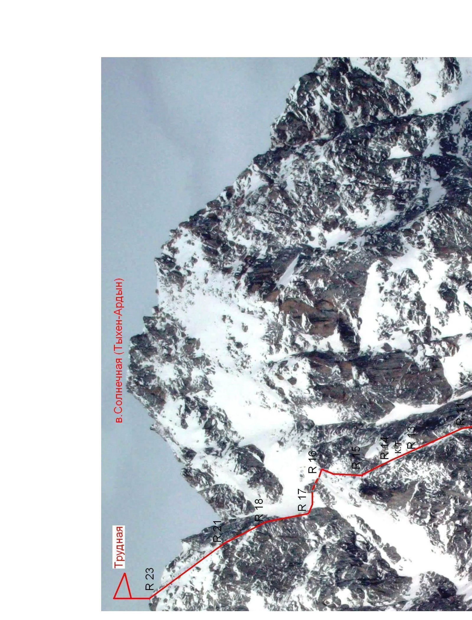 □.
□.
 |  |  |  | 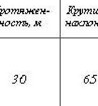 | |
| 30 | 65 | IV+ | 0 | 3 | |
| 20 | 85 | ∇ | 0 | 2 | |
| 15 | 40 | I+ | 0 | 0 | |
| 10 | 90 | ∇ | 1 | 1 | |
| 30 | 55 | III | 0 | 2 | |
| 35 | 60 | III+ | 0 | 2 | |
| 45 | 65 | IV | 1 | 3 | |
| 40 | 40 | III | 0 | 0 | |
| 20 | 80 | IV+ | 0 | 4 | |
| :--: | :--: | :--: | :--: | :--: | :--: |
2. Trudnaya (5A)