42
GENERAL PHOTO OF MUNKU-SARDYK PEAK.
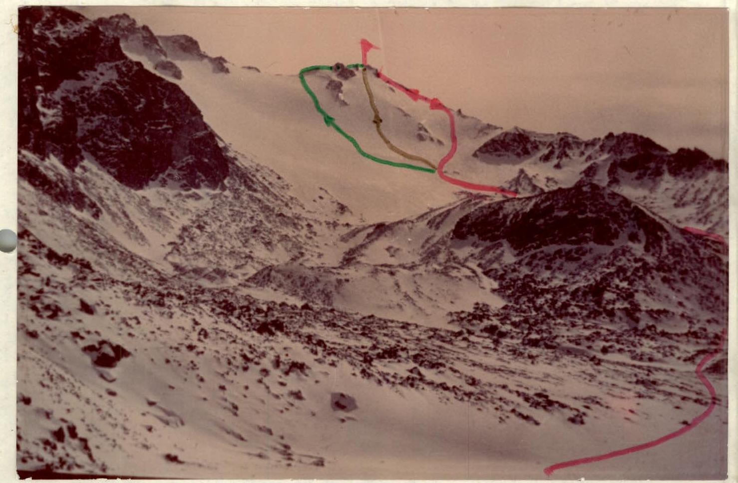
Legend:
- 1B category difficulty route
- 2A category difficulty route
- 2B category difficulty route
BRIEF DESCRIPTION OF THE CLIMBING AREA.
The Eastern Sayan is a vast mountain system stretching from the upper reaches of the Yenisei to the southern tip of Lake Baikal. It is characterized by striking contrasts:
- vast, almost flat watershed uplands alternate with picturesque, rugged mountain ranges,
- some significant rocky peaks are covered with glaciers.
A general feature of the Eastern Sayan relief is a step-like rise to the southeast, where the Tunkin and Kitoi Goltsy mountains and the Bolshoy Sayan ridge are located. This ridge is home to the highest peak in the Eastern Sayan — Munku-Sardyk (3491 m).
The Bolshoy Sayan ridge is bounded to the east by the Tunkinskaya depression and to the south by the Khubsugul depression. The Beliy and Cherniy Irkut rivers originate here, merging into a single stream — the Irkut River. The Cherniy Irkut area is extremely picturesque. Narrow gorges covered with diverse vegetation, fast rivers, and streams give this area a unique character and distinctiveness.
In winter and spring, the rivers are filled with numerous icings and icefalls, making it easier to traverse these places.
The cirque of Munku-Sardyk peak is of glacial origin, surrounded by sheer walls of unnamed peaks. The average height difference of the wall sections is 400–500 m. A small glacier is located just below the peak, fed by the slopes of the summit. The forest boundary is at an altitude of 1600–1800 m. Above this lies a zone typical of polar tundra. The wildlife is diverse.
The difficulty of mountaineering in this area is related to its great remoteness from populated areas (compared to the Tunkin Goltsy range). The Munku-Sardyk peak is on the USSR state border, which requires official registration for access to the border zone.
CLIMBING AREA MAP.
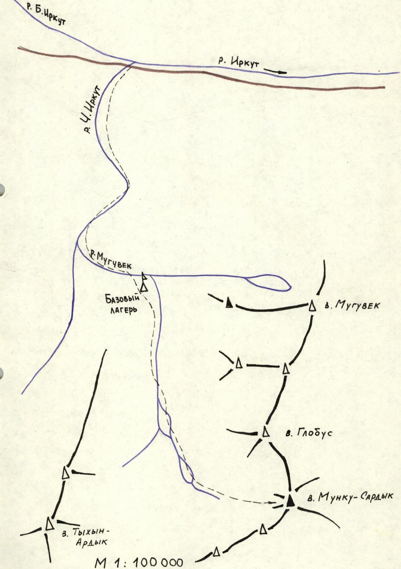
DESCRIPTION OF THE APPROACH TO THE ROUTES.
One can reach the area as follows:
- Take a regular bus along the Tunkinskaya valley to the Mondy settlement.
- Mondy has a border outpost.
- Drive along the Mondy-Orlik road to the confluence of the Beliy and Cherniy Irkut rivers (25 km).
Follow the Cherniy Irkut, directly on the icings, to the mouth of the Muguvek River. The first kilometer is through the Muguvek gorge, which features icefalls and ice cascades. Upon exiting the narrow gorge, the forest ends, and about half a kilometer further, at the forest boundary, is the base camp site. The area has thickets of:
- caragana,
- kashkara,
- chandalash
with rare coniferous trees.
The approach from the highway to the base camp takes 2.5–3 hours. Along the left bank of the Muguvek River, the ascent to Munku-Sardyk peak takes 3–3.5 hours. The route to the first lake is via large scree slopes, and to the second lake via a couloir filled with large boulders.
After the second lake, Munku-Sardyk peak comes into full view. The approach is to the right, through two glacial terraces.
ASCENT DETAILS.
- Climbing area, ridge: Eastern Sayan, Bolshoy Sayan ridge.
- Peak, its height, ascent route, route type: Munku-Sardyk peak, 3491 m via the North Ridge, combined.
- Expected category difficulty: 2A category difficulty.
- Route characteristics: height difference 1100 m, average slope 25°.
- Number of pitons used: rock 2, ice 1.
- Number of travel hours: 4 hours.
- Leader's name, participants, their qualification: Yakovenko A.N. — CMS, participant Belyaev S.A. — CMS, participant
- Date of departure and return: March 5, 1987.
- Organization: year-round mountaineering event under the auspices of the Irkutsk Regional Sports Committee.
ASCENT SCHEME IN SYMBOLS.
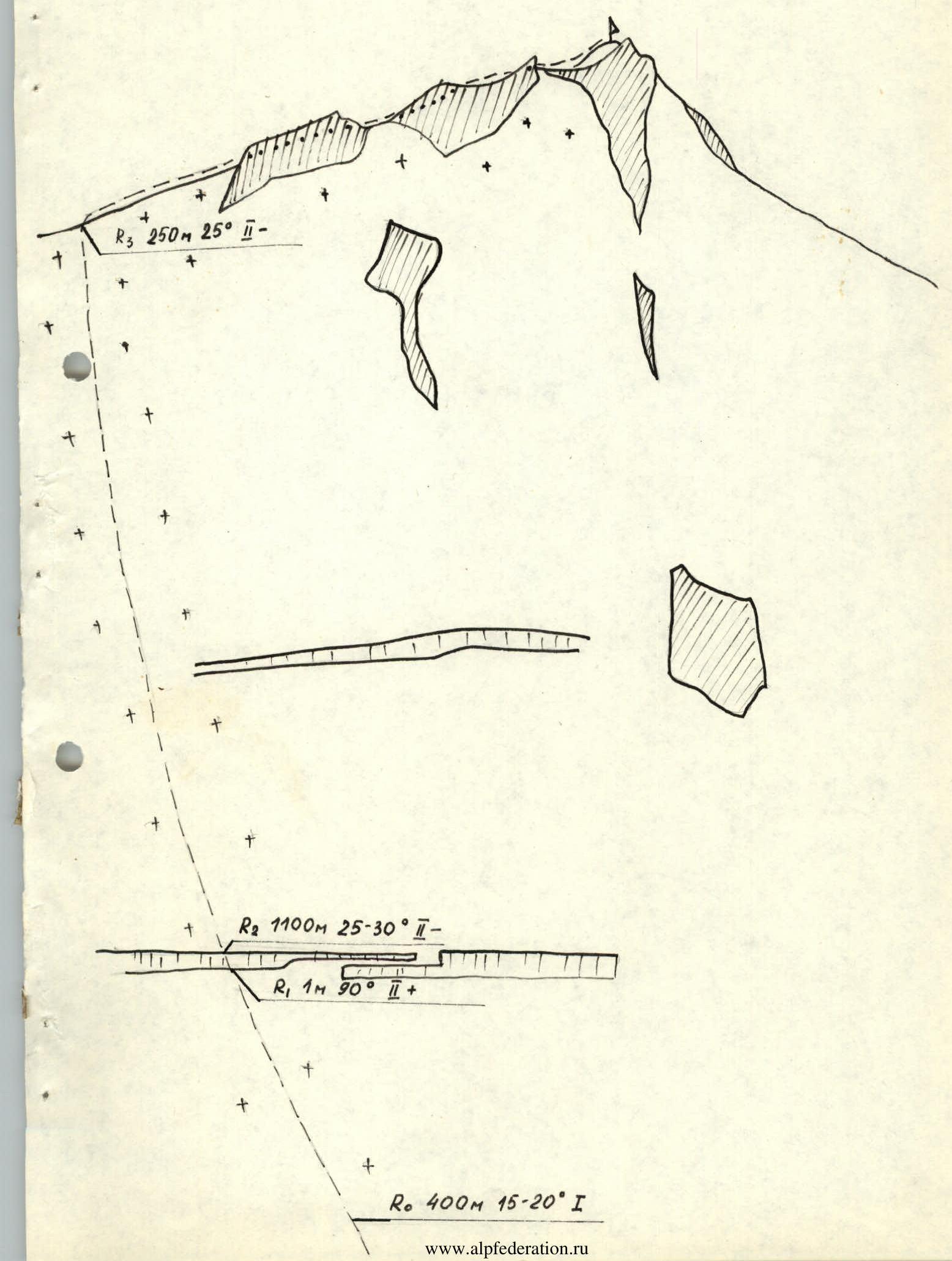
- R3 (250 m, 25°)
- R2 (1100 m, 25–30°)
- R1 (1 m, 90°)
- R0 (400 m, 15–20°, 1)