Report
on the first ascent of Peak 4900 m via the Northwest wall through the Big Gendarme
South-Western Pamir, North Shugnansky Ridge, "Varzob" altitude camp
Leader: PANCHENKO E. G. Participants:
- SLAVINSKAYA L. V.
- GUROV V. N.
- BOVKUN V. R.
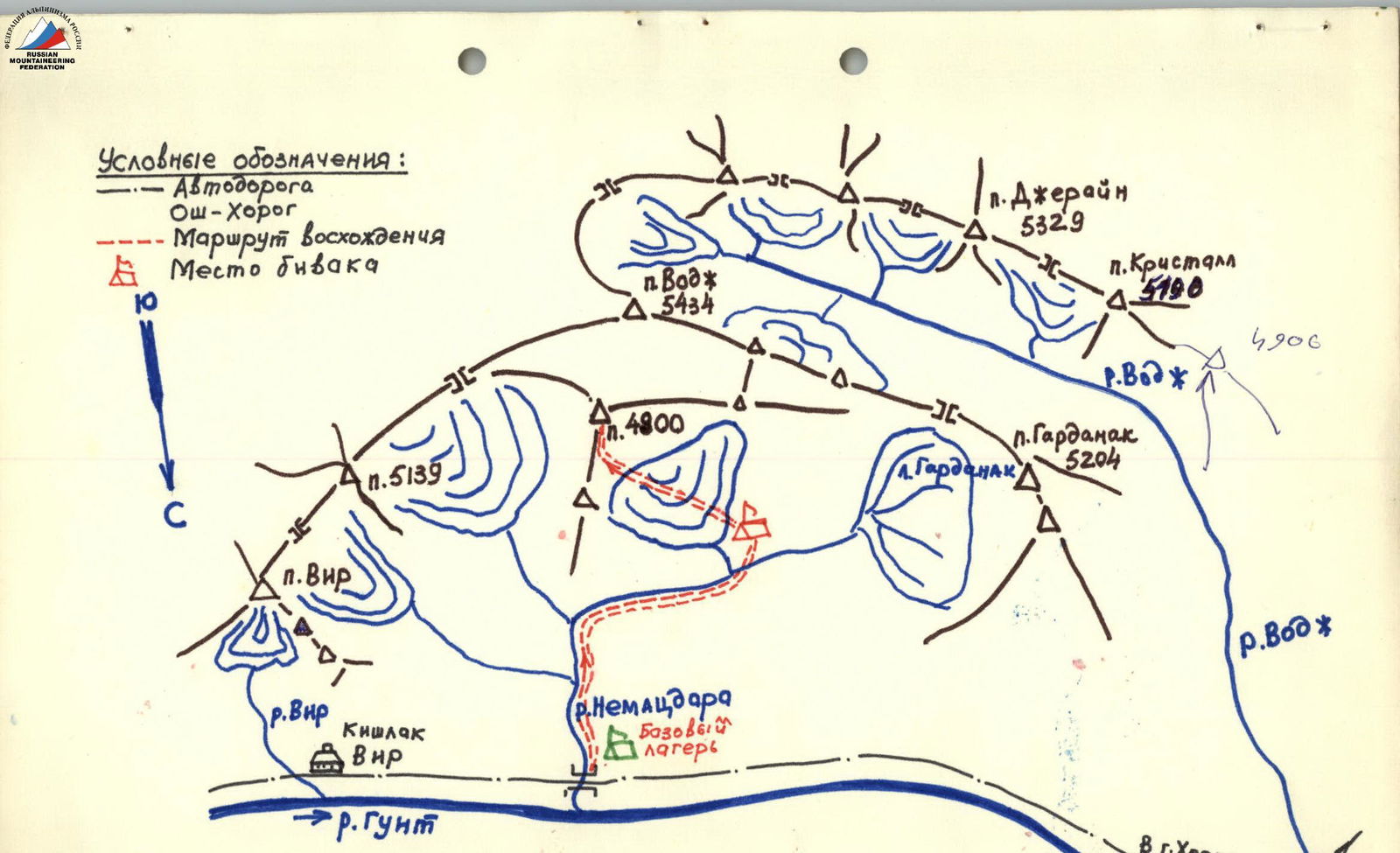
Map of the ascent area
Brief description of the approach to the route
Peak "4900" is located in the north-eastern spur of Peak Vodj (5434 m), which is situated in the North Shugnansky Ridge (South-Western Pamir).
The approach to the cirque, where Peak "4900" is located, is made from the base camp. The site for the camp is:
- near the Horog-Osh road (59 km from Horog)
- by the Gunt River
- close to the confluence of the Nemadara River
- on a green glade
There are sources of drinking water.
Nearby are the villages of Vir and Itap.
Thanks to the road, the necessary conditions for communication are created:
- with settlements along the Pamir Highway
- with the city of Horog
From the base camp on the left bank of the Gunt River, follow the pedestrian path along the stream that flows past the base camp. Passing by a lake and then a large green glade, ascend to the fork near the north-eastern rocky spur of Peak Vodj, which is clearly visible from the base camp. From here, turn right along the stream via medium and large scree - exit into the cirque formed by Peaks "4900" and "5304". The bivouac site is located on the medial moraine of the glacier.
Travel time from the base camp by the Gunt River: 3-4 hours.
Table of main route characteristics
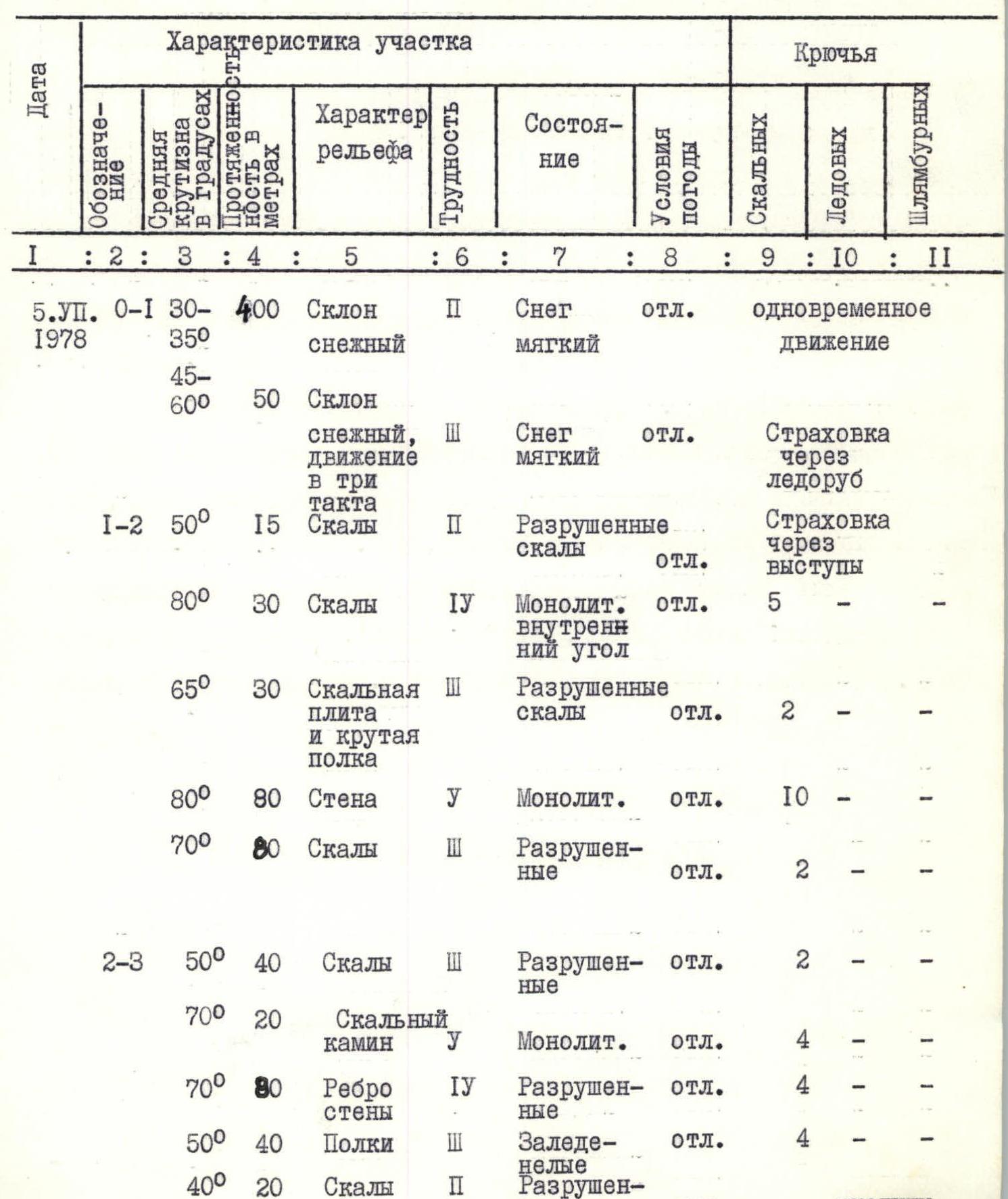
| Designation | Steepness | Length (m) | Nature of relief | Difficulty | Condition | Weather conditions | Rock | Ice | Bolts |
|---|---|---|---|---|---|---|---|---|---|
| R0–R1 | 30–60° | 400 | Snow slope | 2 | Soft snow | excellent | Simultaneous movement | — | — |
| 45–60° | 50 | Snow slope, movement in three paces | 3 | Soft snow | excellent | Ice axe belay | — | — | |
| R1–R2 | 50° | 15 | Rocks | 2 | Destroyed rocks | excellent | Belay through outcrops | — | — |
| 80° | 30 | Rocks | 4 | Monolithic. inner corner | excellent | 5 | — | — | |
| 65° | 30 | Rock slab and steep ledge | 3 | Destroyed rocks | excellent | 2 | — | — | |
| 80° | 80 | Wall | 5 | Monolithic | excellent | 10 | — | — | |
| 70° | 80 | Rocks | 3 | Destroyed | excellent | 2 | — | — | |
| R2–R3 | 50° | 40 | Rocks | 3 | Destroyed | excellent | 2 | — | — |
| 70° | 20 | Rock chimney | 5 | Monolithic | excellent | 4 | — | — | |
| 70° | 80 | Wall edge | 4 | Destroyed | excellent | 4 | — | — | |
| 50° | 40 | Ledges | 3 | Icy | excellent | 4 | — | — | |
| 40° | 20 | Rocks | 2 | Destroyed | excellent | Outcrops | — | — | |
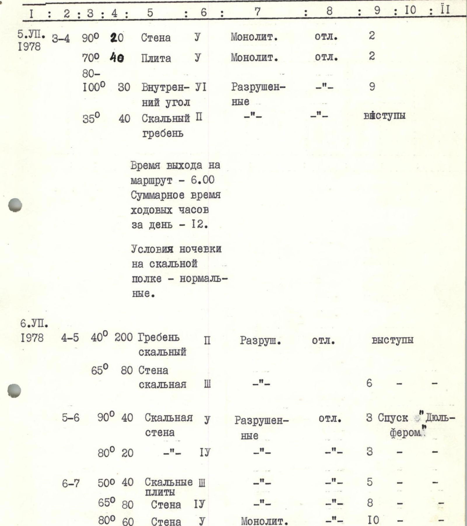
| R3–R4 | 90° | 20 | Wall | 5 | Monolithic | excellent | 2 | — | — |
| 70° | 40 | Slab | 5 | Monolithic | excellent | 2 | — | — | |
| 80–100° | 30 | Inner corner | 6 | Destroyed | excellent | 9 | — | — | |
| 35° | 40 | Rocky ridge | 2 | Destroyed | excellent | Outcrops | — | — | |
| R4–R5 | 40° | 200 | Rocky ridge | 2 | Destroyed | excellent | Outcrops | — | — |
| 65° | 80 | Rocky wall | 3 | Destroyed | excellent | 6 | — | — | |
| R5–R6 | 90° | 40 | Rocky wall | 5 | Destroyed | excellent | 3 | Rappelling | — |
| 80° | 20 | — | 4 | Destroyed | excellent | 3 | — | — | |
| R6–R7 | 50° | 40 | Rocky slabs | 3 | Destroyed | excellent | 5 | — | — |
| 65° | 80 | Wall | 4 | Destroyed | excellent | 8 | — | — | |
| 80° | 60 | Wall | 5 | Monolithic | excellent | 10 | — | — | |
| R7–R8 | 60° | 50 | Rocky ridge, couloir | 3 | Destroyed | excellent | 2 | — | — |
| 15° | 200 | Rocky ridge | 3 | Destroyed | excellent | Belay through outcrops | — | — |
Exit to the route - 7:00.
Exit to the summit - 14:00.
Total time of walking hours - 7 hours.
Total time of walking hours on sections R0–R7 - 19 hours.
Descent to the Big Gendarme:
- via the ascent route
- then along the northern ridge - 5 hours.
During the passage of the route, the following were hammered for belaying:
- rock pitons - 75
- ice screws - 10
For creating artificial points of support - 4.
Brief explanation of the table
Peak "4900" is located in the North Shugnansky Ridge, in the north-eastern spur of Peak Vodj. The route is mainly rocky. However, the beginning of the route is on a glacier with a gentle snow slope, the steepness of which gradually increases to 60°. Then there is an exit to the rocks under the first wall. The route further passes along the north-western wall of Peak "4900" with an exit to the Big Gendarme of the Northern ridge, after descending from which into the col - exit to the summit.
By its nature, the entire route can be divided into the following sections:
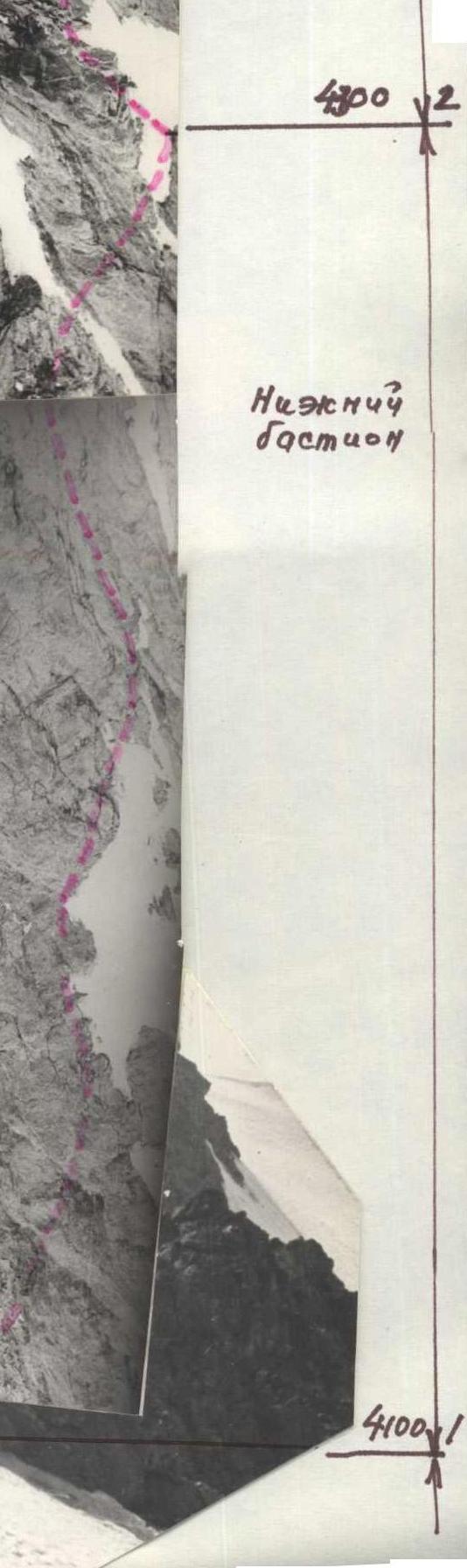
R0–R1 - snow slope R1–R2 - lower bastion R2–R3 - middle bastion - "black wall" R3–R4 - upper bastion R4–R5 - ridge of the Big Gendarme R5–R6 - col R6–R7 - pre-summit ascent R7–R8 - ridge
Below is a description of the route with detailed instructions on the characteristic sections of the ascent path.
R0–R1. From bivouac site No. 1, located on the moraine, move along the snow slope in the direction of the north-western wall of "4900" (1 hour). Initially (400 m), the snow slope is gentle, 30-45°, and at the end, before exiting to the rocks, its steepness increases to 60° (50 m). The upper part of the snow slope is passable "in three paces", belay via ice axe. Exit to a rocky narrow scree ledge 20 m to the left of a rocky outcrop, clearly visible on the snow.
R1–R2. Above the rocky scree ledge hangs a cornice, which is bypassed to the right along rocks of medium difficulty (15 m, average steepness 50°), and then move straight up along the inner corner formed by a large stone and a section of the wall (30 m, 80°). Belay initially through outcrops, and then (in the inner corner) - via pitons. It should be emphasized that on the route, rocks composed of sandstone are often encountered, in which ordinary rock pitons do not create a sufficiently reliable belay. Therefore, it is advisable in some places to use ordinary ice screws instead of rock pitons. After the inner corner, exit to a slab 8 m (steepness 70°), which is passed along a crack and leads to a steep scree ledge (22 m, 60°). From the ledge straight up the wall (20 m, 85°), and then left and up (20 m, 60°) in the direction of a clearly defined inner corner. In the inner corner, there is remnant ice, so it is passed along the left wall (40 m, 85-90°), exit to a small scree ledge. From the ledge straight, and then right and up (80 m, 70°), be cautious, live rocks! - along rocks of medium difficulty, exit to a wide scree ledge with snow under the "second bastion" - "black wall" - Control Point R2. From the bivouac, 8-9 hours.
R2–R3. The second bastion is a wall, along which in some places streams flow from the snow slope located above, which gives the wall a characteristic black color. The wall is smooth, has in some places overhanging sections, so it is passed along the left edge. Bypassing the wall along the snowy couloir in the upper part is dangerous due to the unreliability of the snow, which lies in a thin layer, and also due to rockfall hazard in the couloir.
From the wide scree ledge, move left and up along rocks next to the snow lying on the ledge (40 m, 50°), then right into the inner corner turning into a chimney, which is closed at the top by a probe passage to the black wall and exit to a small (for 2 people) ledge (20 m, 70°). From here, left and up along the edge of the wall (right part of the snowy couloir, turning below into a chimney), and then right and up along the steep left edge of the wall - exit to a steep ledge on which snow lies (60 m, 75°). Above the ledge hangs the upper bastion, which is passed to the right. Therefore, further movement - traverse of the steep ledge with snow and remnant ice to the right (40 m, 50°) and ascent along a small ridge under the right part of the upper bastion (20 m, 40°) along destroyed rocks of medium difficulty. Control Point R2.
R3–R4. The upper bastion - "Red Wall" - is passed along the right vertical edge. The overhanging cornice is bypassed to the right along a "psychological" narrow (20 cm) ledge - 5 m, and then ascent straight up the wall 20 m (90°), further movement along a steep slab 40 m (70°) and inner corner with overhanging cornices - exit to the ridge (30 m, 80-100°). The passage of the upper bastion is one of the key sections of the route. Here, complex climbing, backpacks are pulled up, the first person goes in galoshes on a double rope, ladders are used. When overcoming the bastion, 13 pitons were hammered, 4 of them for creating artificial points of support. Movement is complicated by the presence of a significant number of "live rocks" on the section, especially in the upper part of the inner corner. On the ridge formed by destroyed rocks (30-35°) - a bivouac site, on one of the ledges of the ridge. From the second control point - 4 hours.
R4–R5. From the ledge, move straight up along the destroyed ridge along rocks of medium difficulty (200 m, 40°) in the direction of the Big Gendarme on the northern ridge. Exit to the right shoulder of the gendarme along large rocky blocks (80 m, 65°).
R5–R6. Descent from the Big Gendarme into the col initially to a small ledge (15 m, 90°), and then to the next ledge (35 m, 90°). Further along small ledges on the left part of the gendarme, descend to the saddle behind the gendarme (20 m, 80°). The gendarme is composed of sandstone, which complicates the organization of descent due to a large number of "live" rocks. For organizing the descent, only standard ice screws are used. Control Point R3. From the bivouac - 3 hours.
R6–R7. From the col straight up in the direction of the summit. Initially, move along slabs (40 m, 50°), then a strongly destroyed wall (80 m, 60-65°). Be cautious, many live rocks. Further straight up along the steep black wall, which is passed in the left part along holds (60 m, 80°), and exit through the pre-summit ascent (50 m, 60°), rocks of medium difficulty, destroyed.
From the col 2-3 hours. R7–R8. To the summit, move along a sharp, slightly rising ridge (200 m), 1-1.5 hours.
Descent from the summit to the col via the ascent route, and from here through the Big Gendarme along the northern ridge to the bivouac on the onion glade.
Descent from the summit:
- 6-8 hours.
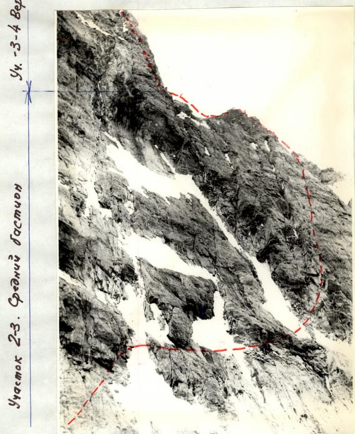
Photo 4. Section R2–R3. Upper part of the middle bastion.
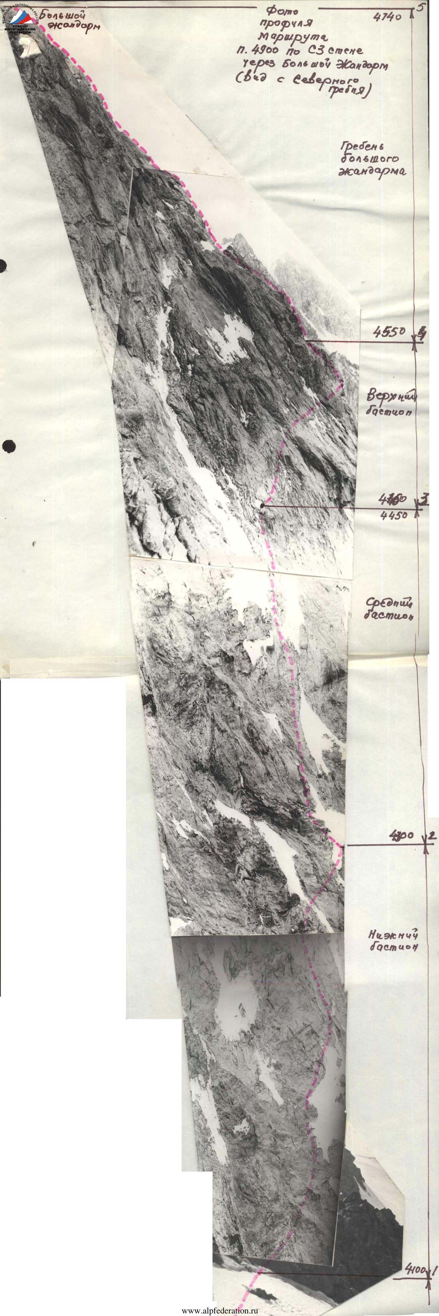 Photo of the profile of the route to Peak 4900 via the NW wall through the Big Gendarme.