REPORT
ON THE FIRST ASCENT OF PEAK 4900 VIA THE EAST RIDGE
SOUTH-WESTERN PAMIR
NORTHERN SHUGNAN RANGE a/l "VARZOB"
Leader: KOSTRICHENKO V.V. Participants: VESELOV A.N. NICHIPORENKO A.N. TRONOV Y.N. BELINSKY S.F. SENTSOV S.K.
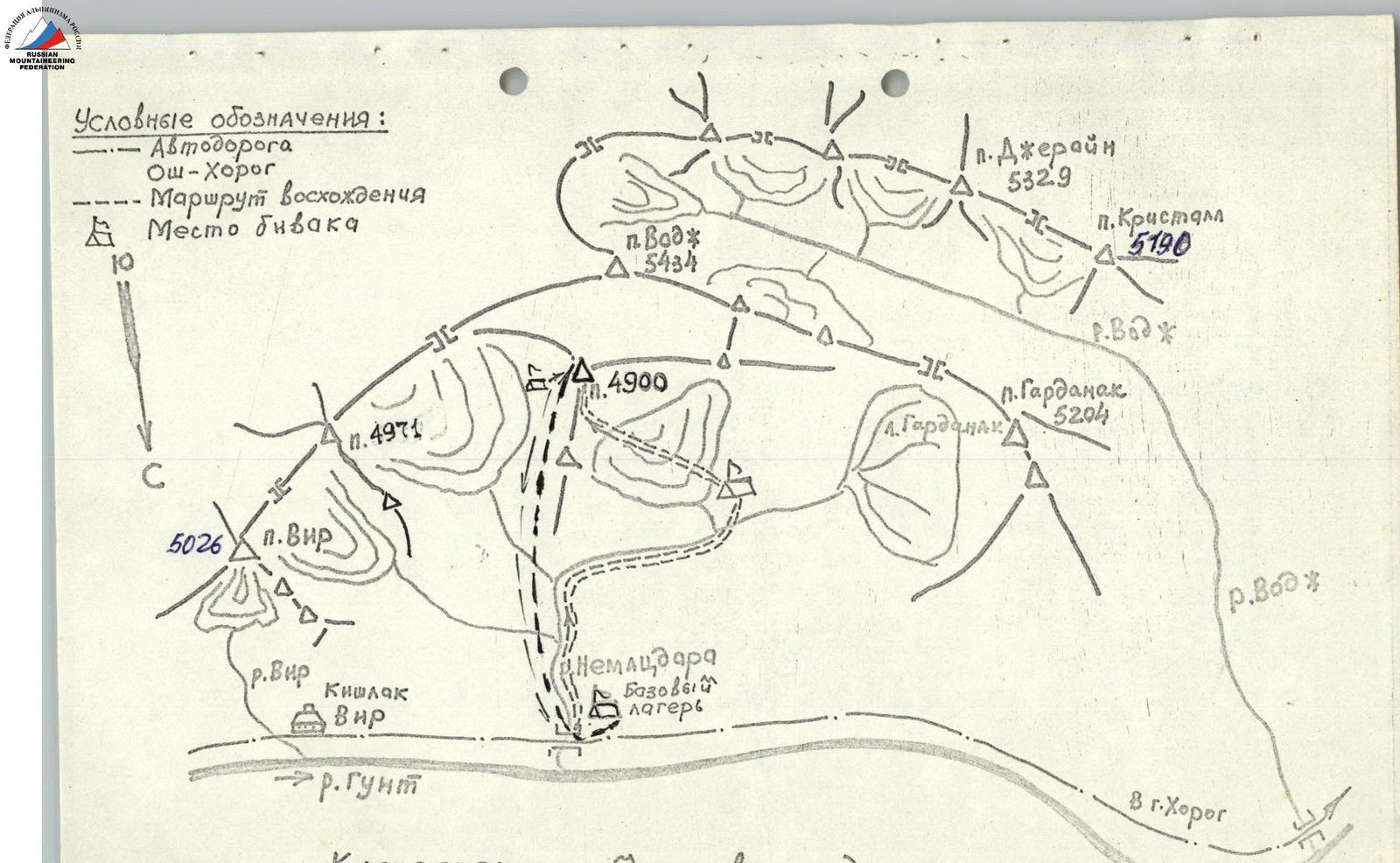
MAP OF THE ASCENT AREA
BRIEF DESCRIPTION OF THE APPROACH TO THE ROUTE
Peak 4900 is located in the north-eastern spur of the Shugnanskiy Range in the South-Western Pamir, in the spur of Peak Vodzh.
The approach to the route is made from the base camp, which is located near the Khorog-Osh road (59 km from Khorog), by the Gunt River. There are sources of drinking water. Nearby are the villages of Vir and Shtam. Convenient conditions for communication with both Khorog and Osh.
From the base camp on the left bank of the Gunt River, the route goes right along the trail up the gorge in the direction of Peak 4900, which is clearly visible from the base camp. After 2.5 hours of walking, there is a good place to spend the night under the route. Lukovaya Polyana is a safe place. There is drinking water and flat areas.
EXPLANATION OF THE TABLE
Peak 4900 is located in the spur of Peak Vodzh 5434. The route is a purely rocky ridge with an average steepness of 60°.
By its nature, the entire route can be divided into the following sections:
- R0–R1 Destroyed rocky ridge
- R1–R2 Monolithic ridge
- R2–R3 Ridge
- R3–R4 Ridge
- R4–R5 Ridge
- R5–R6 Ridge
- R6–R7 Ridge
- R7–R8 Ridge wall
- R8–R9 Ridge
- R9–R10 Ridge
- R10–R11 Summit ridge
BRIEF DESCRIPTION OF THE ROUTE
R0–R1 The route begins along the destroyed ridge 120 m under the wall. Movement is simultaneous, insurance is provided by rock outcrops on the ridge.
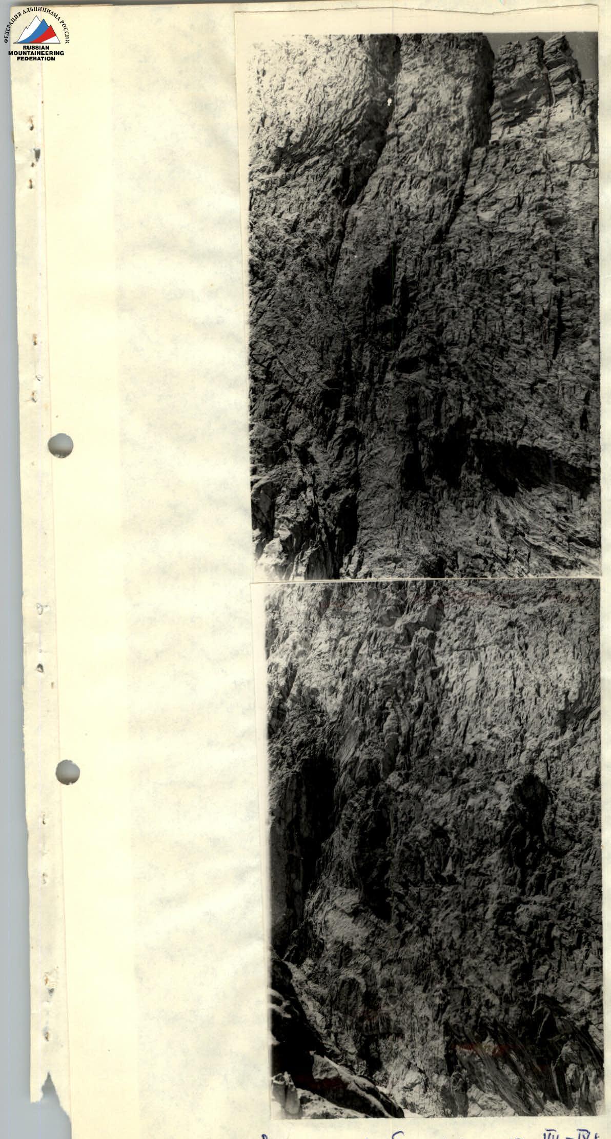
R1–R2 The ridge leads to a steep edge 85°, it is necessary to go along the inner corner in the direction of the cornice. The cornice is passed along a crack on artificial footholds. Above the cornice is a steep 70° sharp plate ridge. The rocks are strong monolithic blocks. Climbing is very difficult, of the highest category. It is climbed in places using ladders.
R2–R3 Further along the ridge 70° in the direction of a gendarme in the form of a tooth. Here, above the "Tooth", a control cairn was left.
R3–R4 The group reached this place by 14:00. From the "Tooth" to the cairn, there is one rope of complex climbing. In front of the cairn, driven pitons were left. Here is a place to spend the night. A small shelf between two walls. There is snow.
R4–R5 Further along the ridge to the right, bypassing the wall along indistinct chimneys with blind cracks. The steepness of the section is 70°. Climbing is complex. After 80 m, there is an exit to the slabs. There are driven pitons.
R5–R6 Along the slabs, there is an exit to the destroyed ridge 40° and along it to a saddle. The ridge is approximately 4th category of difficulty. The ridge leads to a wall on the ridge. Here the group stayed overnight. The place is a destroyed ridge. You can set up a tent. There is snow.
R6–R7 The wall is climbed along the right third of the wall along a crack on artificial footholds, after 20 m there is a reception point. Pitons were left. Further along the right part of the monolithic slabs of the ridge, there is an exit to the ridge itself. These 80 m are the most difficult section of the route, both technically and psychologically. Further along the sharp ridge with a steepness of 80° under the summit tower.
R7–R8 Passage of the summit tower. Movement upwards along the slabs in the direction of the yellow wall. Exit to a narrow shelf. Climbing is complex. Wide cracks. For insurance, wedges, ice screws, and shвеллеры are better. Holds are minimal. From the shelf along the chimney to the pull-off and further on ladders along the system of cracks to the right along the shelf on the wall to the control cairn.
R8–R9 From the control cairn straight up 120 m of complex climbing, exit to the pre-summit ridge.
R9–R10 Further, the ridge becomes gentler, up to 35°. The rocks are destroyed, approximately 3rd category of difficulty. Movement is simultaneous. After 120 m, there is an exit to the ridge leading to the summit and along it.
R10–R11 The ridge consists of sharp slabs. Insurance is provided by outcrops. Approximate steepness is 30°, length is 120 m.
The summit is a rocky tower 6 meters high, 3 × 3 m in size.
The descent from the summit is along the ridge towards Peak Vodzh to a snowy couloir. From the ridge to the couloir to the snow, 1 rope is used on the rocks. Descent is by rappel and further 4 ropes of steep snow until the couloir becomes gentler, and along it to the glacier, and bypassing the icefall to the right down to the overnight stay. Movement on the glacier is in teams. The descent from the summit to the overnight stay takes 4 hours.
Appendix No. 2
TABLE OF MAIN CHARACTERISTICS OF THE ASCENT ROUTE TO PEAK 4900 ALONG THE EAST RIDGE 5B CAT. DIFF.
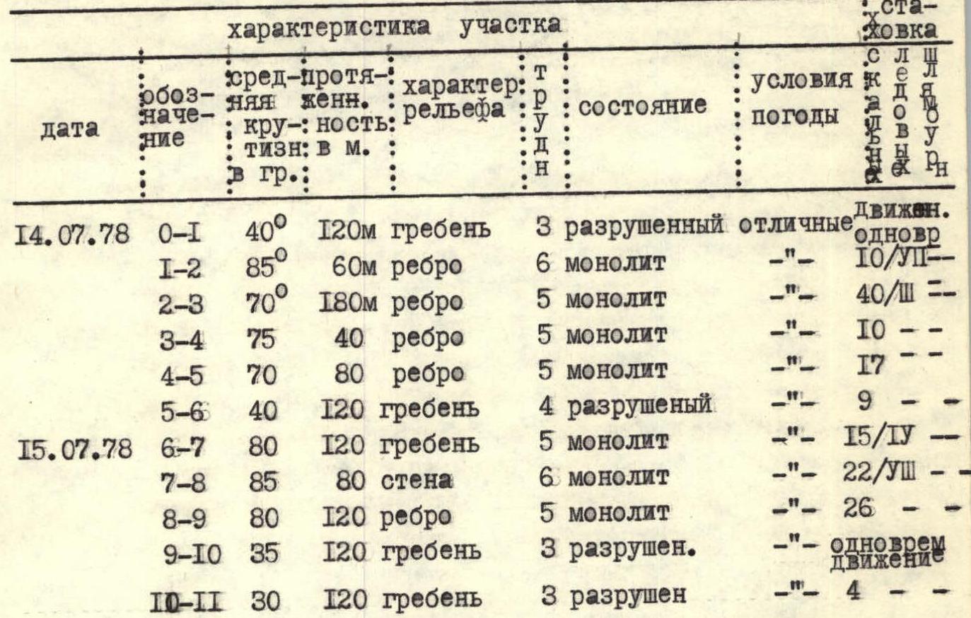
| Date | Designation | Average steepness in degrees | Length in meters | Character of relief | Condition | Weather conditions | Insurance | Movement |
|---|---|---|---|---|---|---|---|---|
| July 14, 1978 | R0–R1 | 40° | 120 m | ridge | 3 destroyed | excellent | simultaneous | |
| R1–R2 | 85° | 60 m | edge | 6 monolithic | " | 10/VII | ||
| R2–R3 | 70° | 180 m | edge | 5 monolithic | " | 40/III | ||
| R3–R4 | 75° | 40 m | edge | 5 monolithic | " | 10 | ||
| R4–R5 | 70° | 80 m | edge | 5 monolithic | " | 17 | ||
| R5–R6 | 40° | 120 m | ridge | 4 destroyed | " | 9 | ||
| July 15, 1978 | R6–R7 | 80° | 120 m | ridge | 5 monolithic | " | 15/IV | |
| R7–R8 | 85° | 80 m | wall | 6 monolithic | " | 22/VIII | ||
| R8–R9 | 80° | 120 m | edge | 5 monolithic | " | 26 | ||
| R9–R10 | 35° | 120 m | ridge | 3 destroyed | " | simultaneous movement | ||
| R10–R11 | 30° | 120 m | ridge | 3 destroyed | " | 4 |
Exit to the route on July 14, 1978, at 5:20. Exit to the summit on July 15, 1978, at 15:00. Total time of walking hours - 21 hours. Descent time - 4 hours. During the passage of the route, 163 rock pitons were driven for insurance, 22 for creating artificial footholds, and 0 ice screws. The table is compiled based on the Regulations on the classification of routes.
Section R1–R2
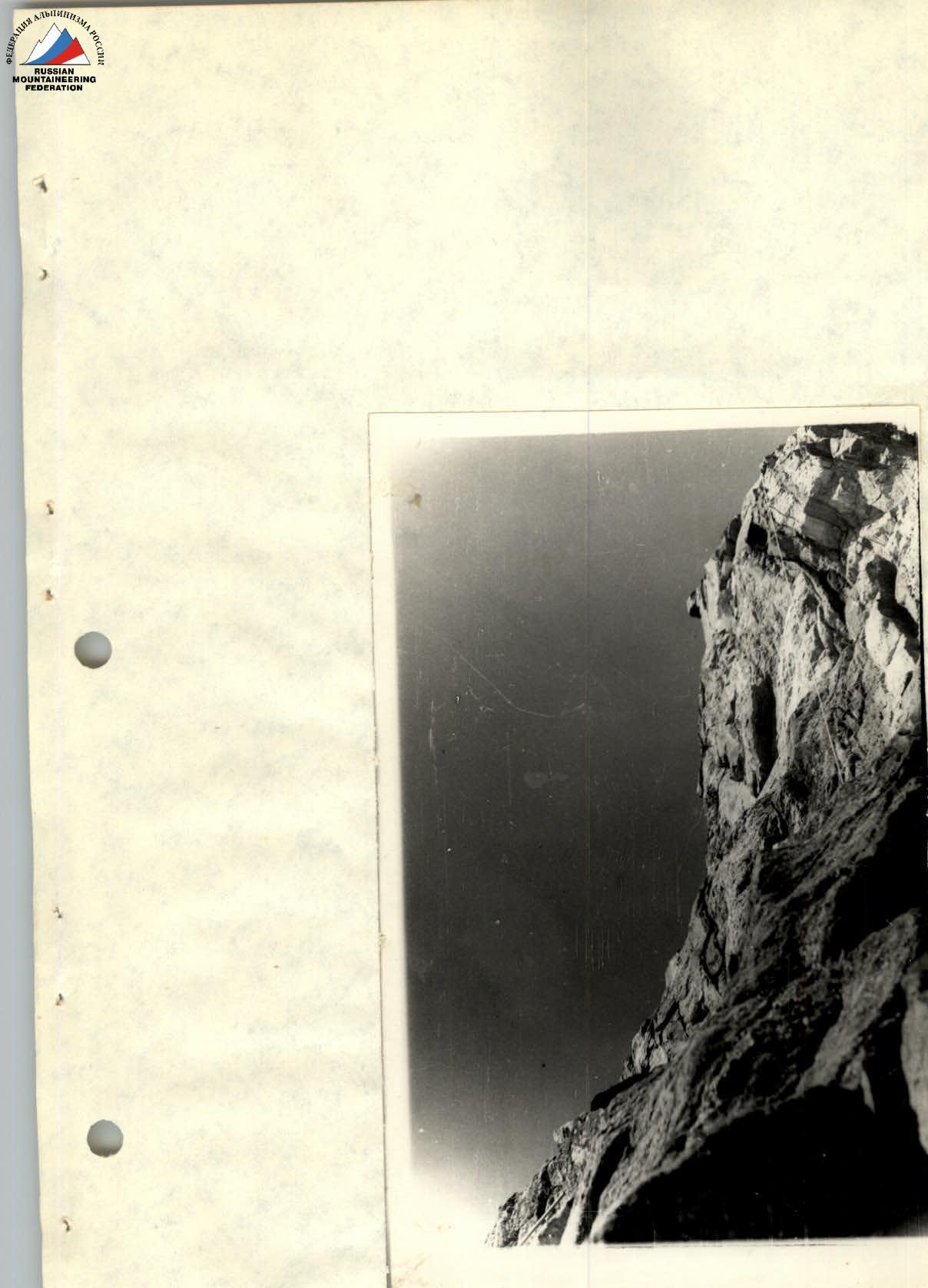
Summit tower R7–R8