Ascent Passport
- Climbing category: technical
- Climbing area (according to KTMGV): South-West Pamir, Shugnan Range.
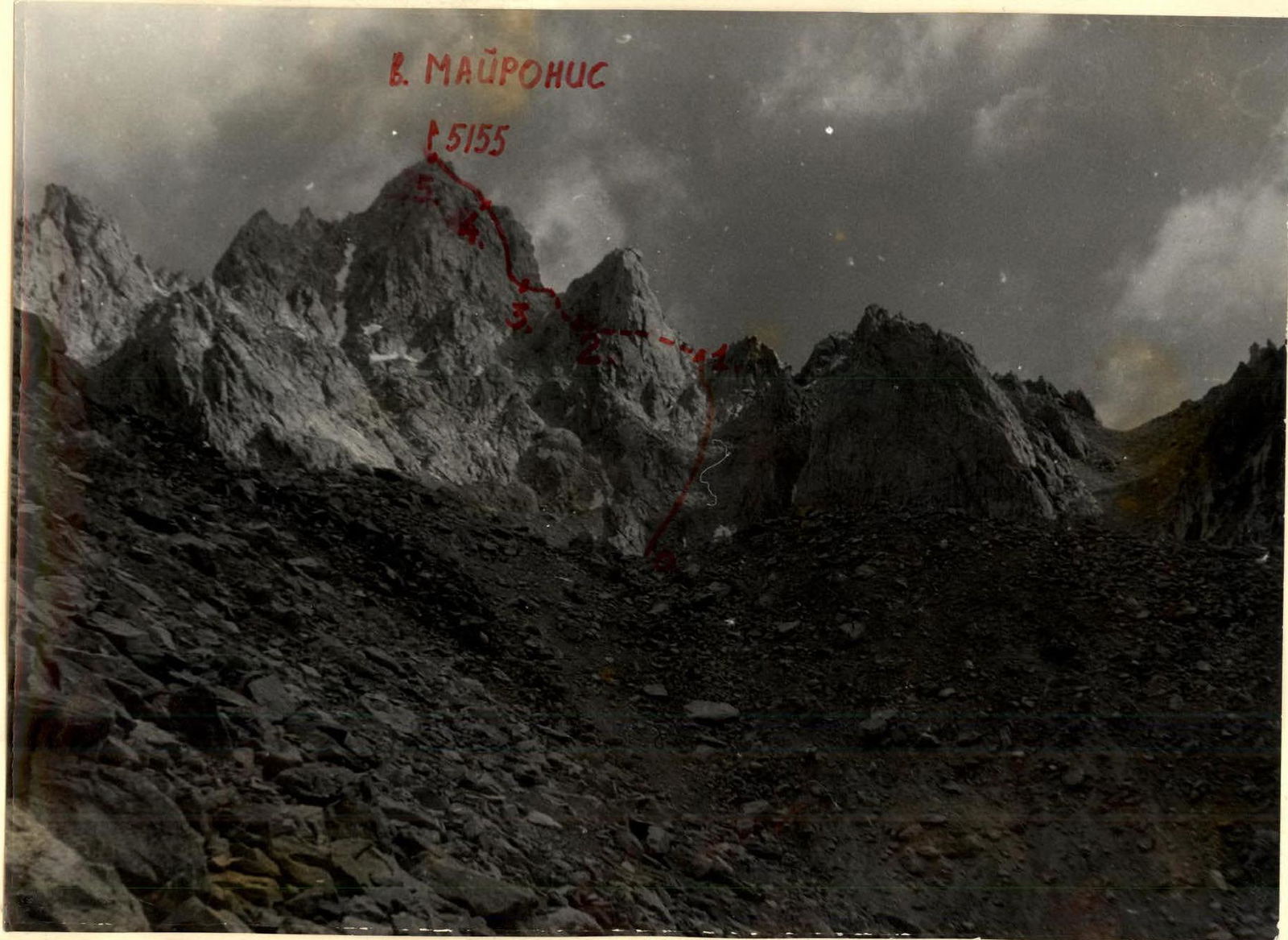
- Peak, its height, and ascent route: p. Mayronis, 5155 m via the South-West ridge.
- Proposed difficulty category: 4B cat. diff., IV.
- Route characteristics: height difference — 955 m; average steepness 55°; length of sections: I — 300 m, II — 200 m, III — 100 m, IV — 80 m, V — 100 m.
- Number of pitons hammered for belaying: rock — 17; ice — none; bolt — none; for creating ITO — none.
- Number of travel hours: 14 h.
- Number of nights and their characteristics: one night at an altitude of 4200 m.
- Team coach: MS Dainius Makauskas.
- Team composition and their sports qualification:
- Virbalis K. A. — 1st sports category, leader.
- Baeras E. A. — 1st sports category.
- Baeras R. A. — 1st sports category.
- Kovalenko A. — CMS.
Brief geographical description of the climbing area
Pamir is one of the highest plateaus in the world, with the majority of it located within the USSR. Within the Soviet Union, Pamir is usually divided into Western (Badakhshan) and Eastern (Pamir proper).
Western Pamir has a sharply erosive relief. In addition to the Akademiya Nauk, Vanch, and Yazgulamsky ranges, there are:
- Rushan;
- Shugnan;
- South-Alichur;
- and Ishkashim ranges.
High-altitude areas are characterized by a sharply continental climate. A harsh, long winter gives way to a short and cool summer.
In Badakhshan and Pamir proper, one can find:
- mountain sheep (argali);
- mountain goat;
- stone marten;
- snow leopard;
- marmot;
- Himalayan monal;
- griffon vulture;
- bears.
The highest peak of the Shugnan Range is Peak Skalisty, 5700 m. The highest peak in the area of our ascents is Peak Pathur (6080 m).
Brief description of the approach to the route
The base camp of expedition No. 222 is located in the village of Jilandy. The approach to the peak is made along the Pamir Highway from the village of Jilandy to the village of Rivak, which is 25 km from the capital of GBAO, the city of Khorog, towards the city of Osh. From here, the road continues to the narzan towards the Bijandara gorge. It was impossible to drive further as a mudflow had blocked the road. We had to walk 12 km on foot with a heavy load.
We set up a bivouac on the bank of the Bijandara River at the foot of nameless peaks.
The next day, we ascended directly up the slope on the left side of the gorge until the trail disappeared, and then continued up to the glacier. From here, the route begins via a steep, narrow couloir.
Route description
The bivouac is located near the Bijandara River at an altitude of 4200 m. Departure at 6:30.
The approach is made directly up the slope. The trail soon disappears. We frequently encountered icy rocks. At 10:30, we reached the glacier. From here, the route begins.
First, we had to ascend via a narrow, steep, scree-filled couloir — 2 h 30 min of work. We had to rope up. Rockfall hazard!
Sections of ice and snow are encountered along the way. We exit the couloir onto a ridge.
From here, the first 5–6 ropes involve traversing rocks. Belaying is done through rock outcrops. The most difficult spot is bypassing the first large boulder, which is encountered immediately from the ridge. The rocks are fragile. Many loose rocks.
The route continues up a 100 m high wall (4–5 ropes):
— First, one rope directly upwards — free climbing, belaying through rock outcrops and rock pitons; — Instead of rock pitons, we used American-type cams; — Then, one rope to the left and upwards — rocks of moderate difficulty, belaying through rock outcrops; — Two to three ropes to the right and upwards — this is how we reached the ridge behind a large gendarme.
From here, we followed a couloir to the most difficult part of the route. Caution! Many loose rocks. It can be especially hazardous in spring and autumn when there is a lot of snow.
The key section of the route is a 70–80 m high wall with a steepness of 80–85%, covered in flow ice. Few holds. We ascended directly upwards, then to the right. Belaying was done through rock pitons and cams. The rocks are very difficult. The wall can be exposed to rockfall, especially in spring and autumn.
The route then leads to the left and upwards for 100 m, and the summit is very close. Rocks of moderate difficulty. We ascended using free climbing. Belaying was done through rock outcrops. This wall, with a steepness of 60–70°, ends at the summit.
The first ascent team assessed the route as 4B cat. diff., as it is much more challenging than all previously classified 3B cat. diff. routes.
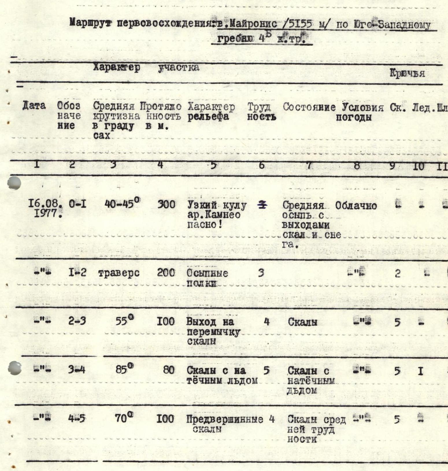
Table of main characteristics of the first ascent route
First ascent route: p. Mayronis (5155 m) via the South-West ridge, 4B cat. diff.
| Date | Section designation | Average steepness, ° | Length, m | Relief characteristics | Difficulty | Condition | Weather conditions | Rock pitons | Ice pitons | Bolt pitons |
|---|---|---|---|---|---|---|---|---|---|---|
| 16.08.1977 | 0–1 | 40–45 | 300 | Narrow couloir. Rockfall hazard! | – | Average scree with rock outcrops and snow. | Overcast | – | – | – |
| – | 1–2 | traverse | 200 | Scree shelves | 3 | – | – | 2 | – | – |
| – | 2–3 | 55 | 100 | Exit to ridge rocks | 4 | Rocks | – | 5 | – | – |
| – | 3–4 | 85 | 80 | Rocks with flow ice | 5 | Rocks with flow ice | – | 5 | 1 | – |
| – | 4–5 | 70 | 100 | Pre-summit rocks | 4 | Rocks of moderate difficulty | – | 5 | – | – |
Team coach: MS Dainius Makauskas.