
SOUTH-WESTERN PAMIR p. KAUNAS (5400 m) via western ridge
| VIRBALIS KESTUTIS | — II grade "ZALGIRIS" |
|---|---|
| KIKAN VALDIS | — 1st sp. grade "DAUGAVA" |
| BAJORAS EUGENIJUS | — II grade "ZALGIRIS" |
| BAJORAS ROMUALDAS | — II grade "ZALGIRIS" |
Brief geographical description of the climbing area
Pamir is one of the highest plateaus in the world, mostly located within the USSR. Within the Soviet Union, Pamir is usually divided into Western (Badakhshan) and Eastern (Pamir proper).
The Western Pamir has a sharply erosive relief. In addition to the Academy of Sciences, Vanch, and Yazgulsky ranges, there are:
- Rushan,
- Shugnan,
- South-Alichur
- and Ishkashim ranges.
High-altitude areas are characterized by a sharply continental climate. A harsh, long winter is followed by a short and cool summer.
In Badakhshan and Pamir proper, there are:
- argali (Marco Polo sheep),
- ibex,
- stone marten,
- snow leopard,
- marmot,
- Himalayan snowcock,
- vulture,
- bears.
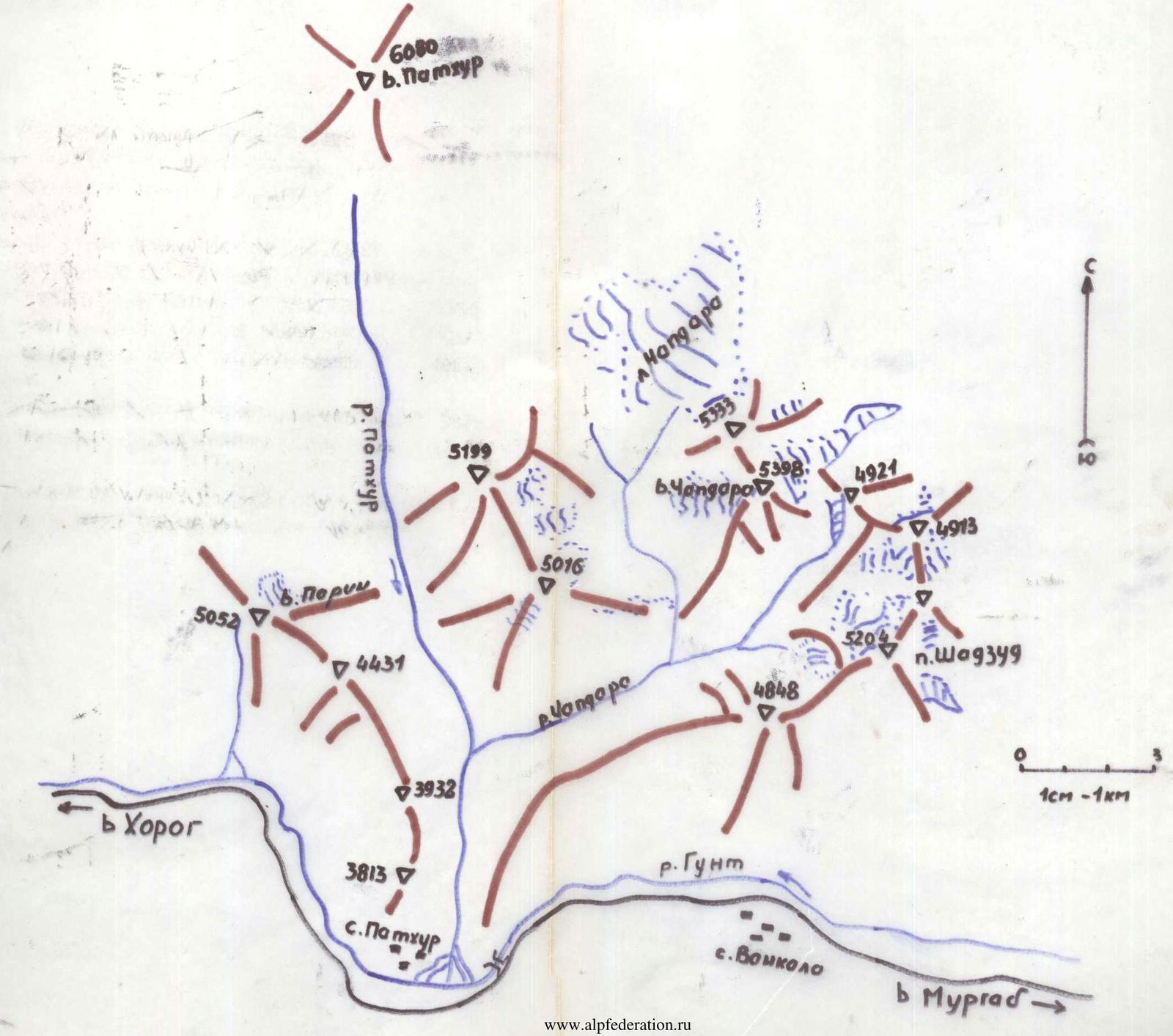
The highest peak of the Shugnan range is Peak Skalisty, 5700 m. The highest peak in the area of our ascents is Peak Pathur (6080 m).
Climbing area map
South-Western Pamir – Rushan range
Brief description of the approach to the route
The base camp of OKE No. 222 is located in the village of Dzhilandy, 125 km from the city of Khorog. The approach to the peak of interest is made along the Pamir Highway from Dzhilandy to Akmamad village, 43 km. Here, on the right side of the road, beyond the Gunt River, lies the village of Pathur, and far at the end of the gorge, the 6080 m Pathur peak is visible.
We went to the left side of the road along the Akmamad gorge, on the left side of the Akmamadar River (in the direction of travel), up the path. The approach to the bivouac takes 3–4.5 hours.
The bivouac was set up in a meadow clearing at an altitude of 3800 m, at the foot of Kaunas peak.
The next day, the approach to the route is made on the left side of the Akmamadar River (in the direction of travel). There was no longer a trail. On the left side, there were vertical walls of the western ridge of Kaunas peak. We walked mainly on medium and large scree. It was visible that a mudflow had passed in some places recently. The approach took 4 hours. The route begins from the moraine along a narrow couloir, with an exit to the ridge.
Route description
The bivouac is located in a meadow clearing at an altitude of 3800 m at the foot of Kaunas peak. Departure for the ascent is at 5:30. The approach to the start of the route is made on the right side of the Akmamadar River (orographically). The river originates at the western ridge of Kaunas peak, flowing from the glacier located there. The path goes along the left side of the glacier (in the direction of travel).
On the left:
- steep cliffs, 350–400 m high;
- immediately behind them, it is necessary to climb up to the left along the moraine to a narrow couloir on the left side.
Next:
- climb the couloir, which leads to the ridge;
- the couloir is narrow, with small and medium scree;
- rockfall hazard!
The approach from the bivouac to the start of the route takes 4 hours. Then, to the right along the ridge wall. First, two ropes (60 m) up to the right. The rocks are very degraded, with many "live" stones. Rockfall hazard! Belay through outcrops and cams (instead of pitons). Steepness 60–70°.
Then, 80 m, traverse to the left. Rocks of medium difficulty, with snow in places. Cams and outcrops are used for belay.
Further, it is necessary to climb 130 m up along degraded rocks. Belay through outcrops, cams are used in places. Rockfall hazard! Then, along the rocks, we reach a narrow couloir. It is necessary to climb up the couloir. In the middle of the couloir, there is a 10 m wall with overhanging rocks at the top. Steepness 80–90°. To reach the wall, climb rocks that are icy in places. Cams were used for belay.
Further along the couloir and rocks of medium difficulty, 100–120 m, is the exit to the ridge. Then along the ridge, 250–280 m. Belay through outcrops.
We approach a large "gendarme". The "gendarme" is bypassed on the left side (in the direction of travel):
- First, one rope (40 m) up along a ledge and through a chimney, 8 m with two "corks";
- Then, along very difficult rocks, partly vertical, — traverse — one rope.
Belay through cams (in their absence, pitons can be used). After the traverse, descent into a large depression onto an ice balcony. Belay through cams.
Further, 80 m along the ridge wall, along rocks of medium difficulty. Belay through outcrops.
Then, an exit to the pre-summit ridge and directly to the summit. Rocks of medium difficulty, belay through outcrops.
We reached the summit at 16:00. Descent along the eastern ridge to a saddle and further to the right along a scree-filled couloir. Down the couloir to the glacier and along the edge of the glacier to the river. Along the riverbank — to the bivouac.
The participants of the ascent rated the first ascent route as category 4A, as it is much more complex than all classified routes of category 3B that were previously climbed.
Table of main characteristics of the first ascent route
First ascent route: p. Kaunas (5400 m) via western ridge, category 4A.
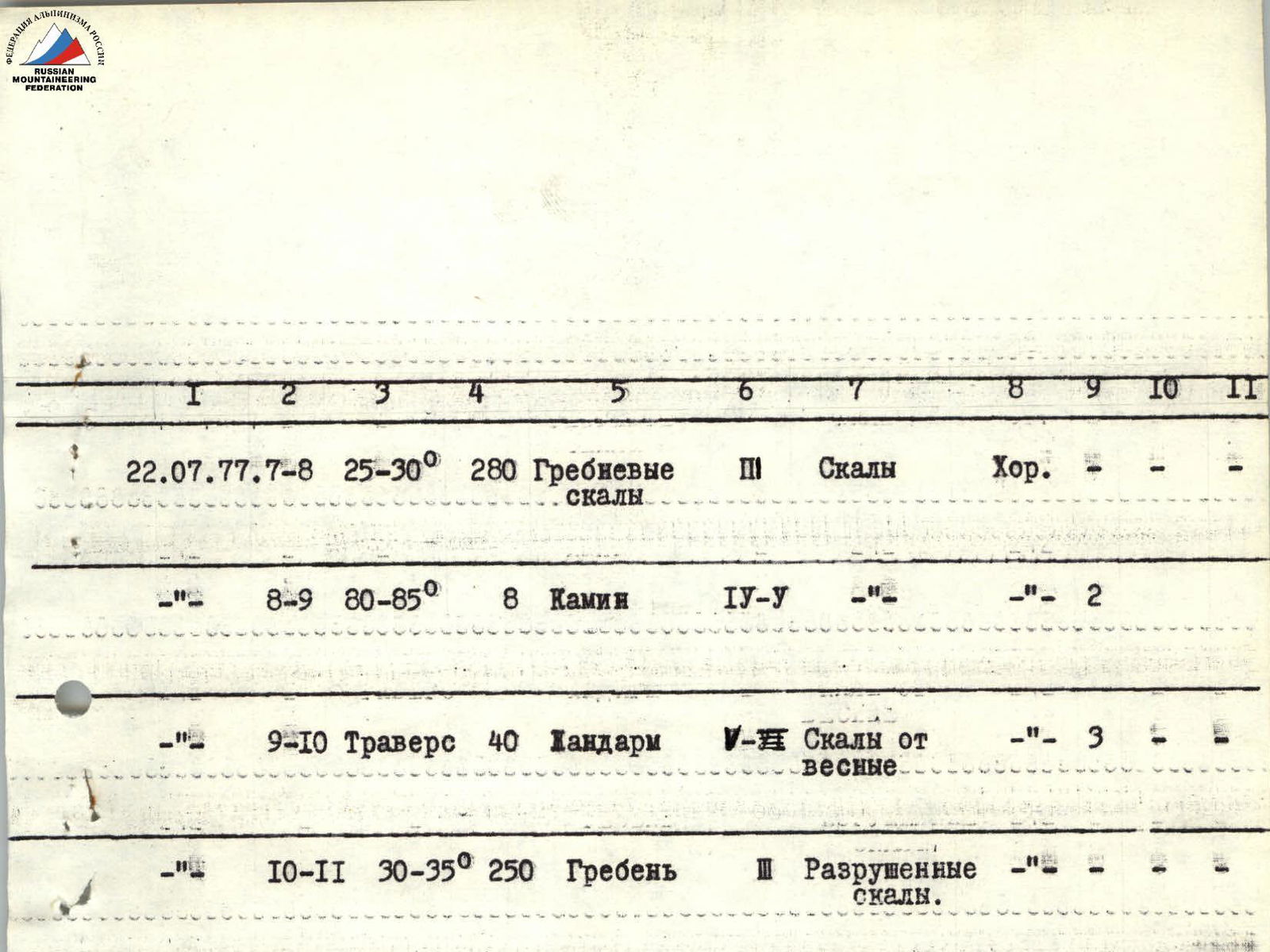
| Date | Section | Steepness | Length | Character of relief | Category of difficulty of section | State | Weather conditions | Pitons / Belay points |
|---|---|---|---|---|---|---|---|---|
| 22.07.1977. | R0–R1 | 40–45° | 300 m | Narrow couloir | Medium | good, scree with rock outcrops. Rockfall hazard! | ||
| 22.07.1977. | R1–R2 | 60–70° | 60 m | Degraded rocks | 4 | Degraded rocks, snow in places | Cams: 4 | |
| 22.07.1977. | R2–R3 | traverse | 80 m | Rock ledges | 3 | Cams: 2 | ||
| 22.07.1977. | R3–R4 | 50–65° | 80 m | Degraded rocks | 3–4 | Degraded rocks | 1 | |
| 22.07.1977. | R4–R5 | 50° | 50 m | 2–3 | Icy rocks. | 1 | ||
| 22.07.1977. | R5–R6 | 90° | 10 m | Rocks | 6 | 3 | ||
| 22.07.1977. | R6–R7 | 60° | 100 m | Couloir | 4 | Degraded rocks. Icy. | 7 | |
| 22.07.1977. | R7–R8 | 25–30° | 280 m | Ridge rocks | 3 | Rocks | Good | |
| 22.07.1977. | R8–R9 | 80–85° | 8 m | Chimney | 4–5 | 2 | ||
| 22.07.1977. | R9–R10 | traverse | 40 m | Gendarme | 5–6 | Vertical rocks | 3 | |
| 22.07.1977. | R10–R11 | 30–35° | 250 m | Ridge | Degraded rocks. |
Team coach: MS D. Makauskas