ASCENT LOG
- Ascent category — technical
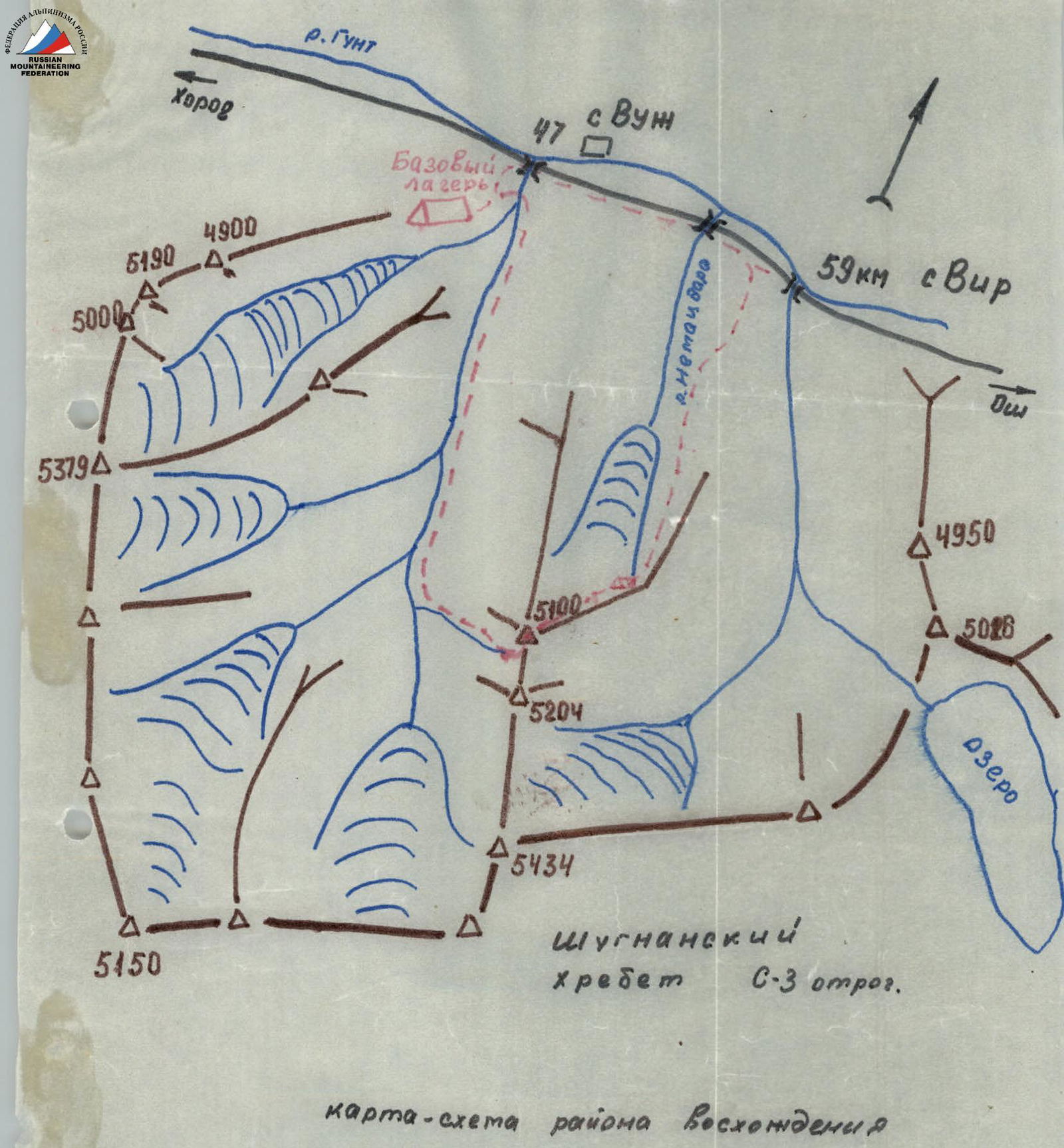
- Ascent area — Shugnan Range
- Peak, its height, and ascent route — northwest spur of GondoRак West (5100) via counterfort of the N wall
- Estimated difficulty category — 5B (2nd ascent)
- Route characteristics:
- height difference — 1100 m
- average slope — 55°
- length of sections:
- III — 780 m
- IV — 560 m
- V — 200 m
- Pitons driven for belaying, including for creating belay anchors:
- chocks 41
- rock 33
- ice 49
- bolt pitons — 2
- Number of climbing hours — 21 hours
- Number of bivouacs and their characteristics — 1 (good)
- Full name of the leader, participants, and their sports qualification:
- Khankevich Andrey Georgievich — 1st sports category (leader)
- Degtyarev Alexander — 1st sports category
- Zybin Alexander Nikolayevich — 1st sports category
- Stepanov Vitaly Alekseyevich — 1st sports category
- Team coach — Honored Master of Sports Kavunenko Vladimir Dmitrievich
- Date of departure for the route — July 18, 1978
Ascent Area Map
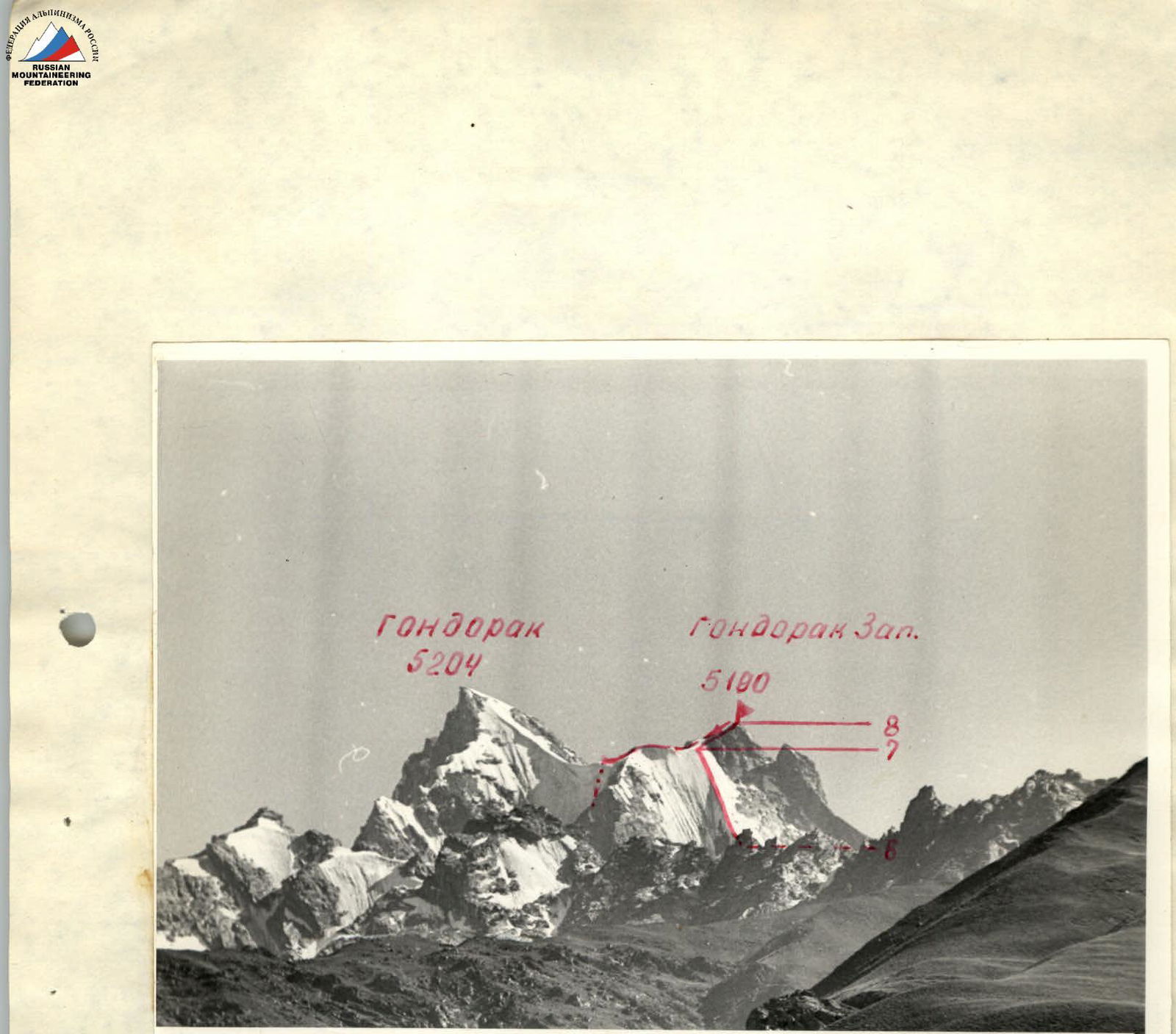
Photo 1. View from the Osh–Khorog road
Route Description
I. Brief description of approaches to the route
From the 51/671 kilometer marker of the Osh–Khorog highway, ascend towards the Gondoрак peak past the ranger's hut via goat trails. After 2 hours of ascent, exit onto a grassy ridge, from where the Gondoрак peak is visible (photo 2).
Further ascent:
- past a destroyed shepherd's hut
- to the 1st step of the glacier's icefall
The first step of the icefall is bypassed on the left (in the direction of travel) via talus shelves and goat trails. Exit into the upper cirque of the glacier, bypassing the 2nd icefall via a large talus shelf that ends at the icefall with a sheer rock wall. The shelf begins midway down the lower step of the glacier, on the left in the direction of travel. The talus shelf leads directly to the bivouac site under the peak (point A in photo 2).
II. Brief explanation of the table of main route characteristics.
From the bivouac site under the route, traverse the glacier, approach the ice ledges, and ascend a snow slope on the left (in the direction of travel) to the bergschrund and then to the ice gorge above the ledges (R0–R1). Cross the gorge from left to right towards the rocks (R1–R2). Ascend a not clearly defined rock counterfort to a couloir (R2–R3). Ascend 60 m up the rock wall of the couloir and then ascend snow to exit under the N wall (R3–R4). The couloir leads to a platform with a cairn. The platform is suitable for a bivouac. Ascend the wall to the counterfort (R4–R5). Ascend the counterfort to the base of the ice "knife" (R5–R6). Bivouac. Ascend the ice "knife" to the saddle between Gondoрак West and Gondoрак Central (R6–R7).
From the saddle:
- ascend a snowfield
- then ascend the SE ridge to the summit (R7–R8)
From the summit, descend to the saddle and then down a snowy couloir towards the Shak-Lar valley. Descent from the saddle to the river takes 3 hours.
Route Conclusion
The route to Gondoрак West via the counterfort of the North wall is a combined route requiring climbers to have skills in overcoming complex rock and ice sections.
The ice "knife" is a protruding counterfort on the large North ice wall. It is impossible to bypass the "knife" on the route, as the wall to the right and left of the "knife" is constantly exposed to falling rocks.
The route itself is not rockfall-prone, except for the beginning of the route. The eastern ridge of Gondoрак West is destroyed, and with sunrise, rockfall often occurs from the East Ridge down the Northeast wall onto the start of the route.
Thus, an early start is recommended for the route (4:00–5:00).
The route corresponds to the 5B difficulty category and is recommended for gaining experience in ice-rock ascents.
Table of Main Characteristics of the Route to Gondoрак West
Route Section Characteristics
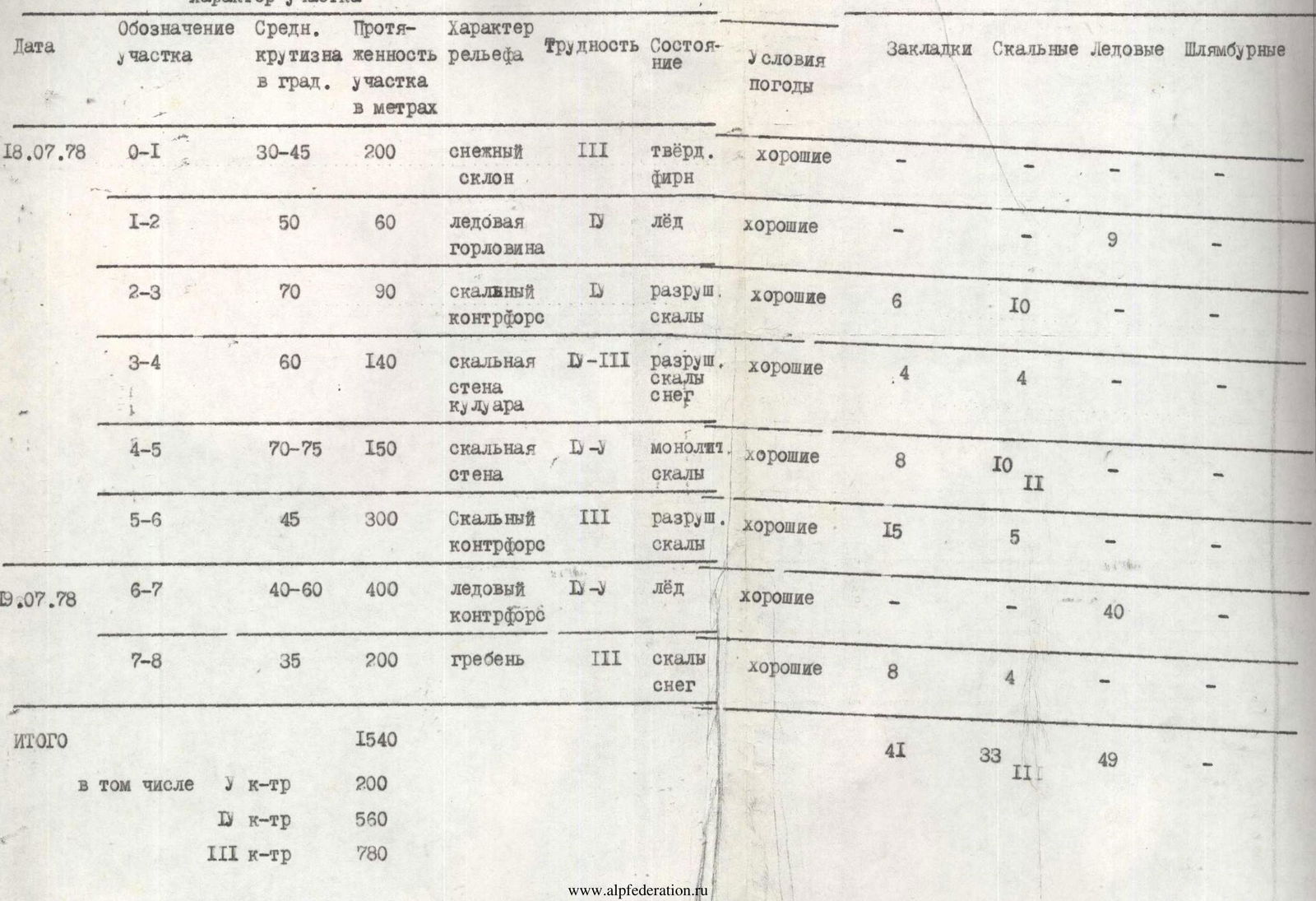
| Date | Route Section | Average Slope, ° | Section Length, m | Relief Type | Difficulty | Condition | Weather Conditions | Pitons: Chocks | Rock | Ice | Bolt |
|---|---|---|---|---|---|---|---|---|---|---|---|
| July 18, 1978 | R0–R1 | 30–45 | 200 | snow slope | III | hard firn | good | – | – | – | – |
| R1–R2 | 50 | 60 | ice gorge | IV | ice | good | – | – | 9 | – | |
| R2–R3 | 70 | 90 | rock counterfort | IV | destroyed rocks | good | 6 | 10 | – | – | |
| R3–R4 | 60 | 140 | rock wall couloir | IV-III | destroyed rocks, snow | good | 4 | 4 | – | – | |
| R4–R5 | 70–75 | 150 | rock wall | IV–V | monolithic rocks | good | 8 | 10 | – | – | |
| R5–R6 | 45 | 300 | rock counterfort | III | destroyed rocks | good | 15 | 5 | – | – | |
| July 19, 1978 | R6–R7 | 40–60 | 400 | ice counterfort | V | ice | good | – | – | 40 | – |
| R7–R8 | 35 | 200 | ridge | III | rocks, snow | good | 8 | 4 | – | – | |
| Total | 1540 | 41 | 33 | 49 | 2 | ||||||
| including | IV | 200 | |||||||||
| V | 560 | ||||||||||
| III | 780 |