
Ascent Passport
I. Ascent Class — Technical 2. Ascent Area — North Shugnanskiy Ridge 3. Peak, its height, and ascent route — Peak "5204" via the center of the eastern wall. 4. Proposed Difficulty Category — 5B 5. Route Characteristics: height difference — 1750 m, average steepness — 61° Length of sections:
- I — none
- II — 300 m
- III — 710 m
- IV — 150 m
- V — 760 m
- VI — 105 m
- Number of pitons:
- Rock: 179 pcs. (for belay), X (for creating ITO)
- Ice: —
- Bolted: —
- Number of travel hours — 35 hours
- Number of overnight stays and their characteristics — 3 overnight stays, normal conditions.
- Surname, name, patronymic of the leader and participants, their sports qualification:
- KORNYS' Jorge-Miguel Nikitovich — CMS, leader;
- BERESNEV Valeriy Prokhorovich — CMS, participant;
- MOLDOVANOV Aleksandr Anatol'evich — CMS, participant;
- KULYAMIN Vladimir Romanovich — CMS, participant;
- Team Coach — KENSITSKIY Leopold Vsevolodovich — Master of Sports of the USSR, senior instructor.
- Departure to the route July 5, 1978. Return to the camp July 9, 1978.
 www.alpfederation.ru↗
 www.alpfederation.ru↗
 www.alpfederation.ru↗
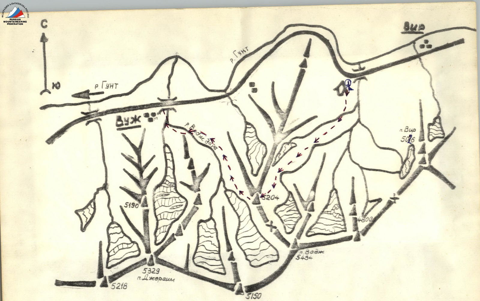
Brief Description of the Approach to the Route
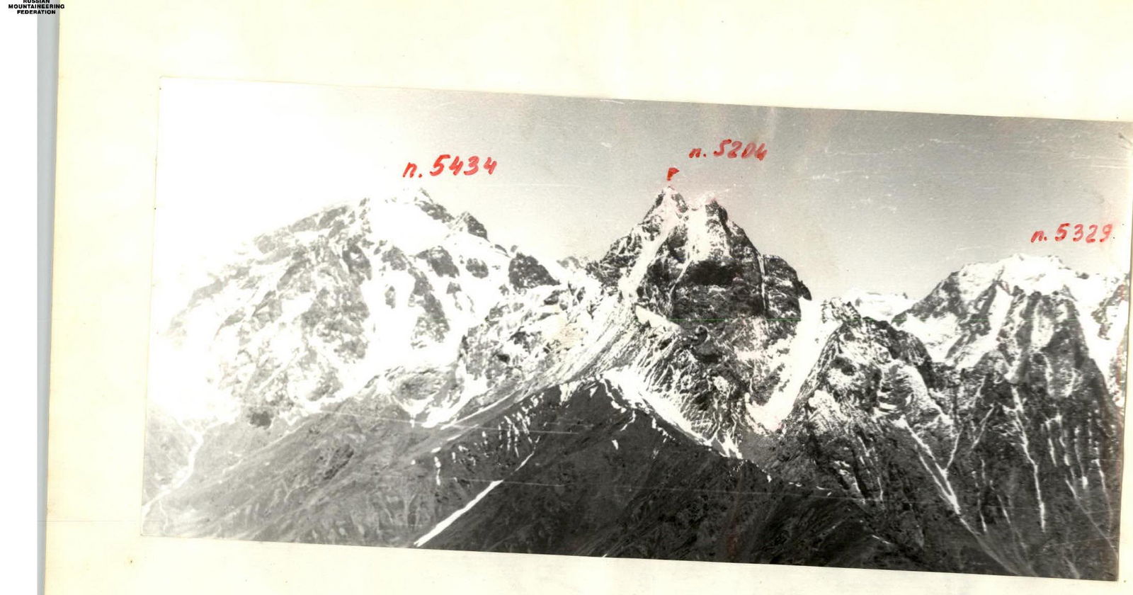
Peak "5204" is located in the North Shugnanskiy Ridge of the Northwest Pamir. The approach to the cirque, above which the peak "5204" is situated, is made from the base camp located at the 59th kilometer of the Osh-Khorog highway, near the confluence of the Nematsdara river into the Gunt river, in a small willow grove.
- There is a good source of drinking water.
- 2 km to the east is the village of Vir.
- There is good transportation communication with the city of Khorog and neighboring villages along the Osh-Khorog road.
The approach to the peak begins from the 59th km of the Osh-Khorog highway. Up the trail to the south along the left bank of the Nematsdara river — exit to the cirque of the glacier flowing from peak "4900" and peak "5204". Time to approach — 3–4 hours.
Brief Explanation of the Table
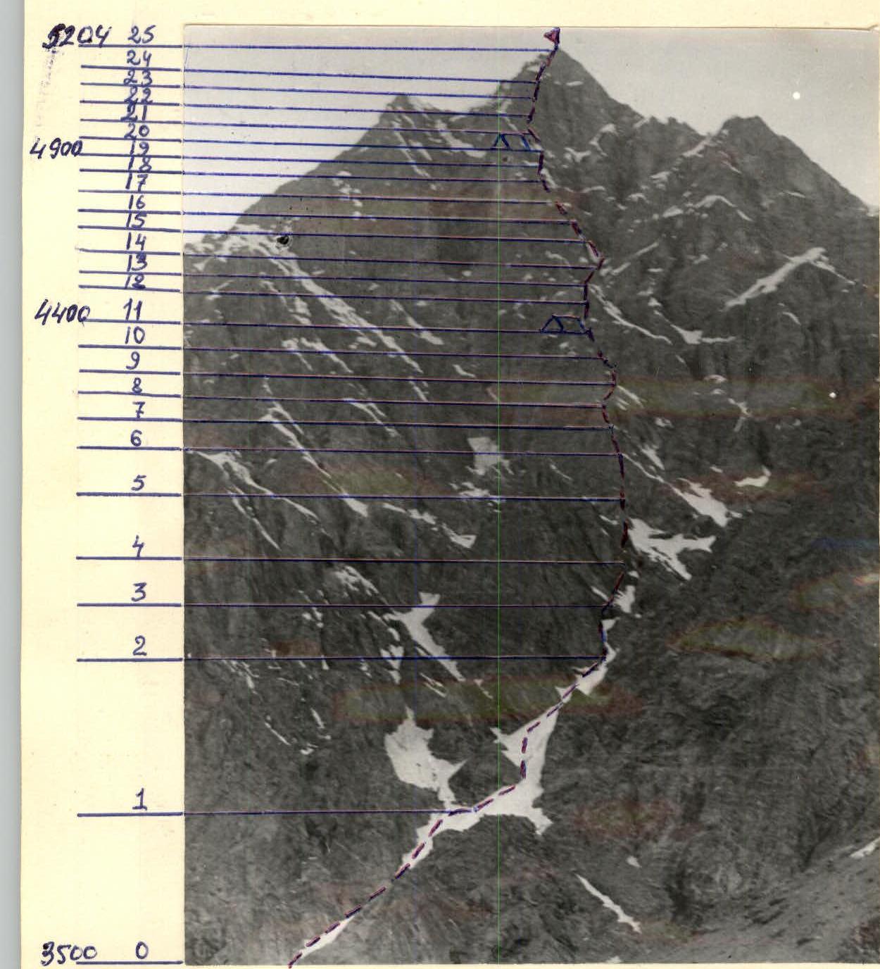
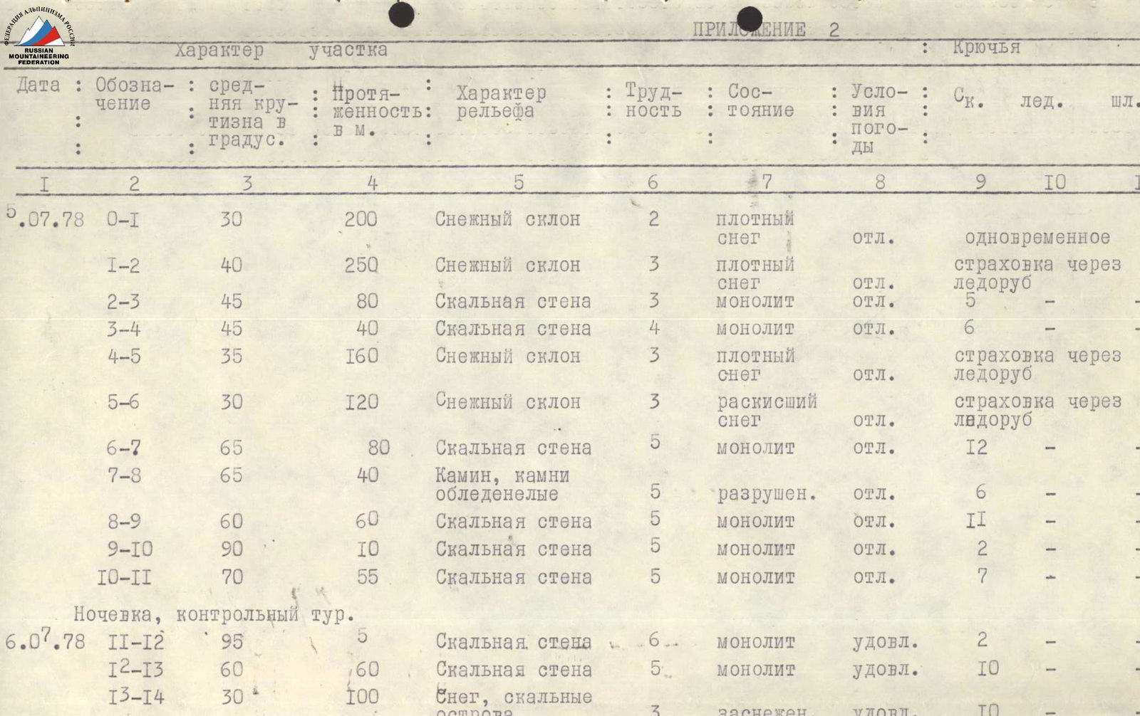
Peak "5204" is located in the North Shugnanskiy Ridge. The route is rock. It begins from the second snow couloir on the right. The couloir leads to the base of the counterfort. Along the counterfort to the base of the summit tower, along the wall of the summit tower — exit to the summit. The entire route can be divided into the following sections:
- Section R0–R1 — snow slope
- Section R1–R2 — snow slope
- Section R2–R3 — rock wall
- Section R3–R4 — rock wall
- Section R4–R5 — snow slope
- Section R5–R6 — snow slope
- Section R6–R7 — rock wall
- Section R7–R8 — chimney, rocks iced
- Section R8–R9 — rock wall
- Section R9–R10 — rock wall
- Section R10–R11 — rock wall
- Section R11–R12 — rock wall
- Section R12–R13 — rock wall
- Section R13–R14 — snow, rock islands
- Section R14–R15 — rock wall
- Section R15–R16 — rock wall
- Section R16–R17 — rock wall
| Section | Description |
|---|---|
| R17–R18 | Rock wall |
| R18–R19 | Rock wall |
| R19–R20 | Rock wall |
| R20–R21 | Rock wall |
| R21–R22 | Rock wall |
| R22–R23 | Rock wall |
| R23–R24 | Rock wall |
| R24–R25 | Snow slope |
Below is a description of the route with a detailed indication of the characteristic sections of the ascent:
- R0–R1: From the bivouac on the moraine along the talus to the base of the second snow couloir on the right. In the middle of the couloir is a landmark — a rock island in the form of a rhombus. The route goes in the direction of this rhombus.
- R1–R2: Along the snow, bypassing the rhombus to the base of the island of the rock ridge. Belay through an ice axe. There may be ice in the couloir.
- R2–R3: The rock ridge is bypassed on the right along rocks of medium difficulty.
- R3–R4: Further to the right along monolithic rocks — exit to a snow couloir.
- R4–R5: Along the couloir 160 m to the base of the sickle-shaped ridge. To the right is a wall with characteristic light stripes; one should go under the wall.
- R5–R6: A 120-meter snow slope leads under the wall.
- R6–R7: Along the wall with a steepness of 65° — exit to a shoulder with snow.
- R7–R8: From the shoulder 40 m in the direction of the waterfall — a chimney filled with ice. First on its right side, then in the center — exit to a ledge under an overhanging rock with black streaks.
- R8–R9: From under the overhanging rock 10 m to the right onto a ledge, then 50 m along monolithic rocks on the right side of the ridge — exit under a small wall.
- R9–R10: The wall turns into a slab. Along the slab to the left 50 m in the direction of an internal corner with a steepness of up to 90°. From the corner — exit to a ledge. Overnight stay. It is not possible to set up a tent. First control point.
- R10–R11: Segment to the left upwards through a cornice — exit to the ridge and along it 60 m upwards under the wall.
- R11–R12: Along the wall, a traverse along the snow in the direction of the yellow belt, clearly visible from the bivouac site on the moraine. On the traverse, a couloir is intersected. In the place of transition through the couloir, falling stones are possible. It is better to cross early in the morning.
- R12–R13: Above the yellow belt, a counterfort begins, leading to the base of the summit tower. The route goes along the right side of the counterfort. Steep, smooth rocks.
- R13–R14: Then exit to a shoulder. On the shoulder — a snow cornice, which is bypassed on the right.
- R14–R15: Further upwards 40 m along steep, wet rocks.
- R15–R16: Along the rocks — exit to a shoulder of the ridge. Very difficult climbing. Steep rocks with a small number of holds. At this place, the route goes to the left side of the counterfort.
- R16–R17: Along the left side of the ridge in the direction of the couloir. When entering the couloir — a very difficult place. Passed using ITO. The couloir leads to a ledge suitable for an overnight stay.
- R17–R18: From the ledge straight upwards along very steep, destroyed rocks under the base of the summit tower. Overnight stay. Second control point.
- R18–R19: Along the wall with a steepness of up to 90° and further along steep snow under the base of the wall of the summit tower.
- R19–R20: The wall of the summit tower is a key section of the route. The route goes along the wall slightly to the right in the direction of an overhanging chimney turning into an internal corner, ending...