
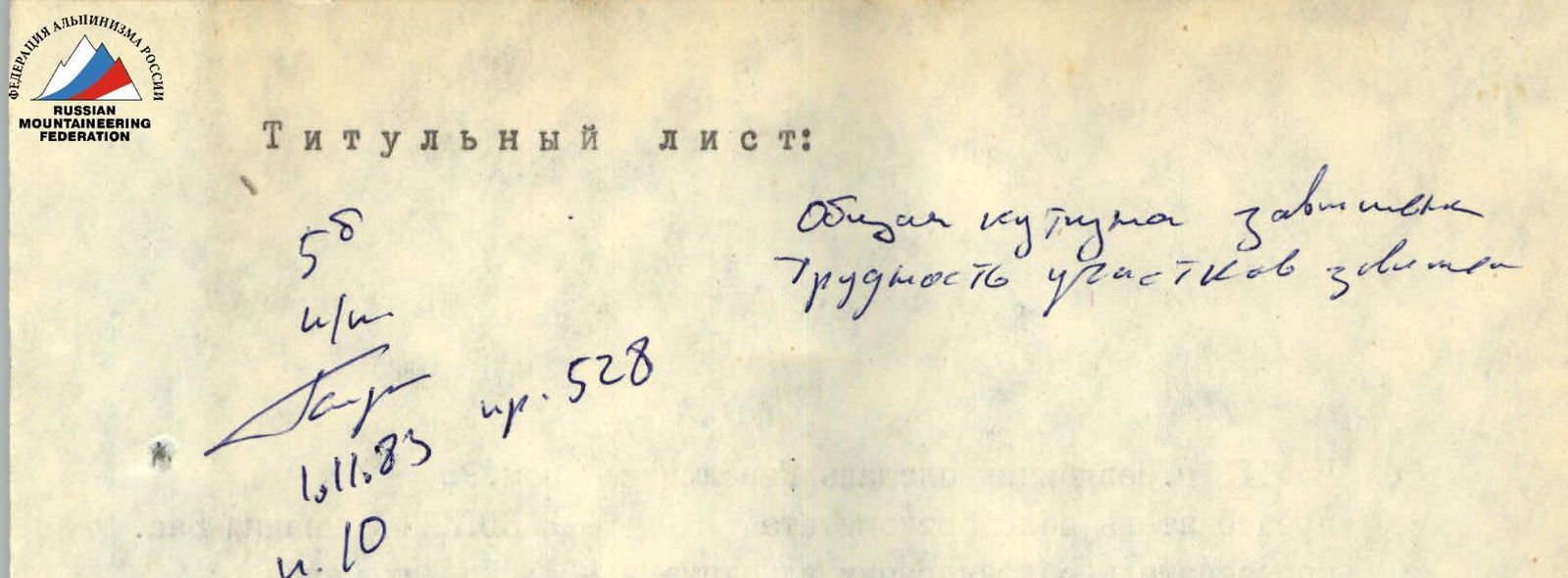
The First RSFSR Climbing Championship
1983
First Ascent Category
Peak Vodzh 5434 m via the counterfort of the northeast wall (first ascent)
Team of the Chelyabinsk Regional Sports Committee
- captain — Kaigorodtsev S.A.
- coach — Tarkhanov V.G.
454043, Chelyabinsk, Revolution Square, 4, room 96 chairman of the regional sports committee — Vanitkin Gennady Vasilyevich, chairman of the regional mountaineering federation — Devin Mikhail Semyonovich
454150, Chelyabinsk-70, Dzerzhinsky St., 31, apt. 10 (for correspondence) Kaigorodtsev Sergey Alexandrovich (captain)
454122, Chelyabinsk, Kuibyshev St., 37, apt. 66, Tarkhanov Vladimir Grigoryevich (coach)
The heights given in the report are determined as follows: the height of the summit — according to topographic survey data obtained in TEC No. 222 of the Main Directorate of Geodesy and Cartography other heights — by altimeter
Ascent Passport
- CLASS — ALTITUDE-TECHNICAL
- REGION — Southwestern Pamir, Shugnan Range
- PEAK — Peak Vodzh 5434 m, first ascent via the counterfort of the northeast wall
- PROPOSED category of difficulty — 5B
- ELEVATION GAIN — 1065 m.
Length of sections with 1st-4th category difficulty — 600 m. Average steepness — 62°.
- NUMBER OF PITS:
| For belay | For creating IT |
|---|---|
| Ice 22 | 1 |
| Rock 57 | 6 |
| Bolt — | — |
Used 64: 8 chocks
-
NUMBER of walking hours (for ascent) — 28
-
NUMBER of bivouacs on the route — two, both comfortable, with water
-
Captain: 1. Kaigorodtsev Sergey Alexandrovich — CMS
Participants:
- 2. Kocherga Yuri Ivanovich — CMS
-
- Mosiychuk Igor Grigoryevich — CMS
-
- Shidlovsky Sergey Vladislavovich — CMS
Coach: Tarkhanov Vladimir Grigoryevich — MS
-
DATES of departure and return — August 23-26, 1983
Mountaineering Federation of Chelyabinsk Region 1983 www.alpfederation.ru ↗
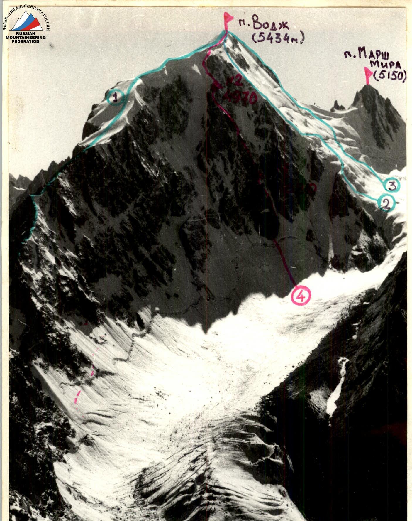
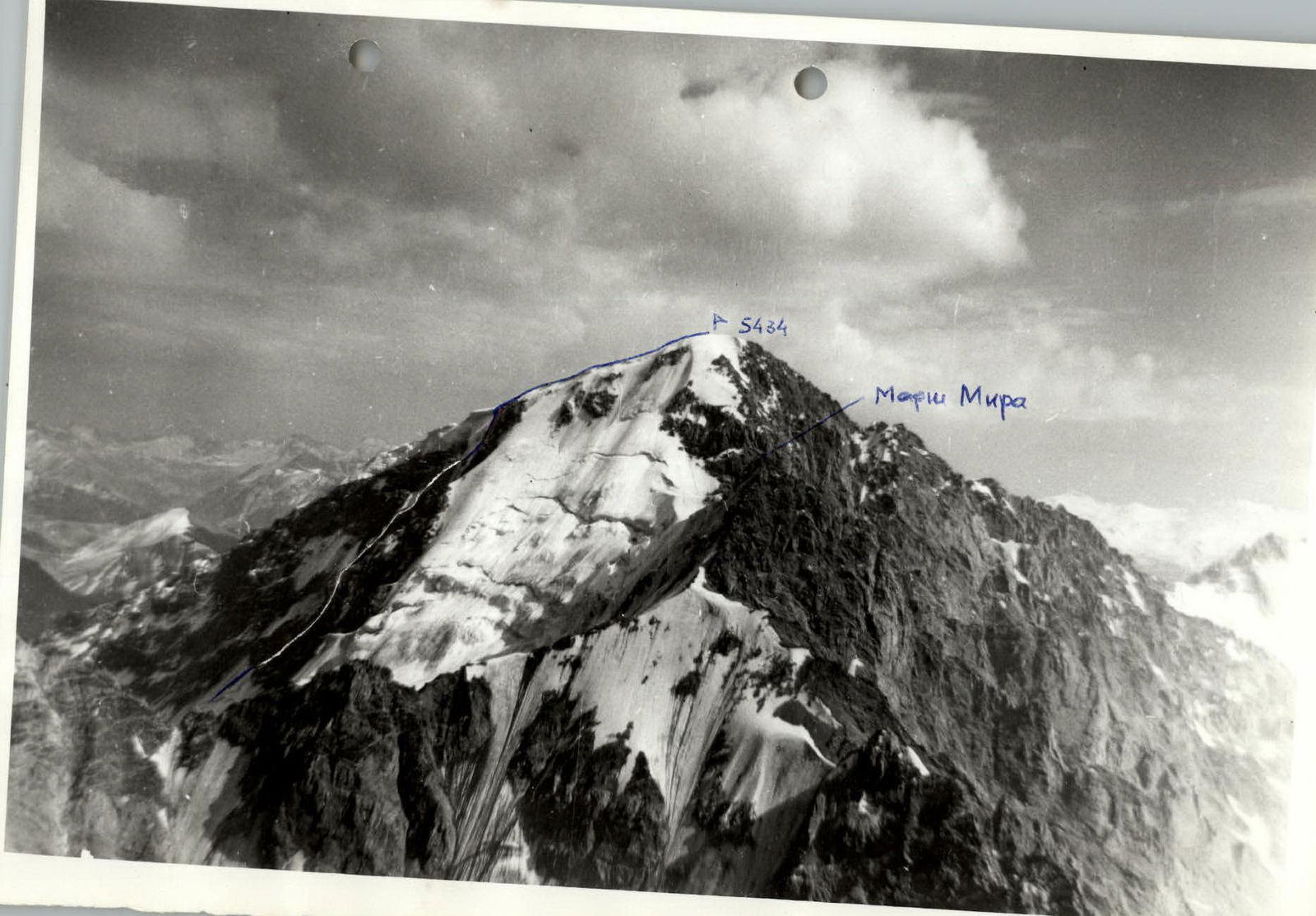
General photo of the summit. Taken on August 15, 1983 at 18:00 from the SW ridge of Peak 4971. Height — 4750 m. Lens: "Helios-44", f=58 mm.
First ascents:
- First ascent of approx. 3A category via the E ridge — V. Tarkhanov +5, August 13, 1983
- 5A category (approx.) via the left edge of the N wall — Yu. Kocherga +3, August 16, 1983
- 5A category (approx.) via the right edge of the N wall — A. Fedyaev +3, August 19, 1983
- The described route
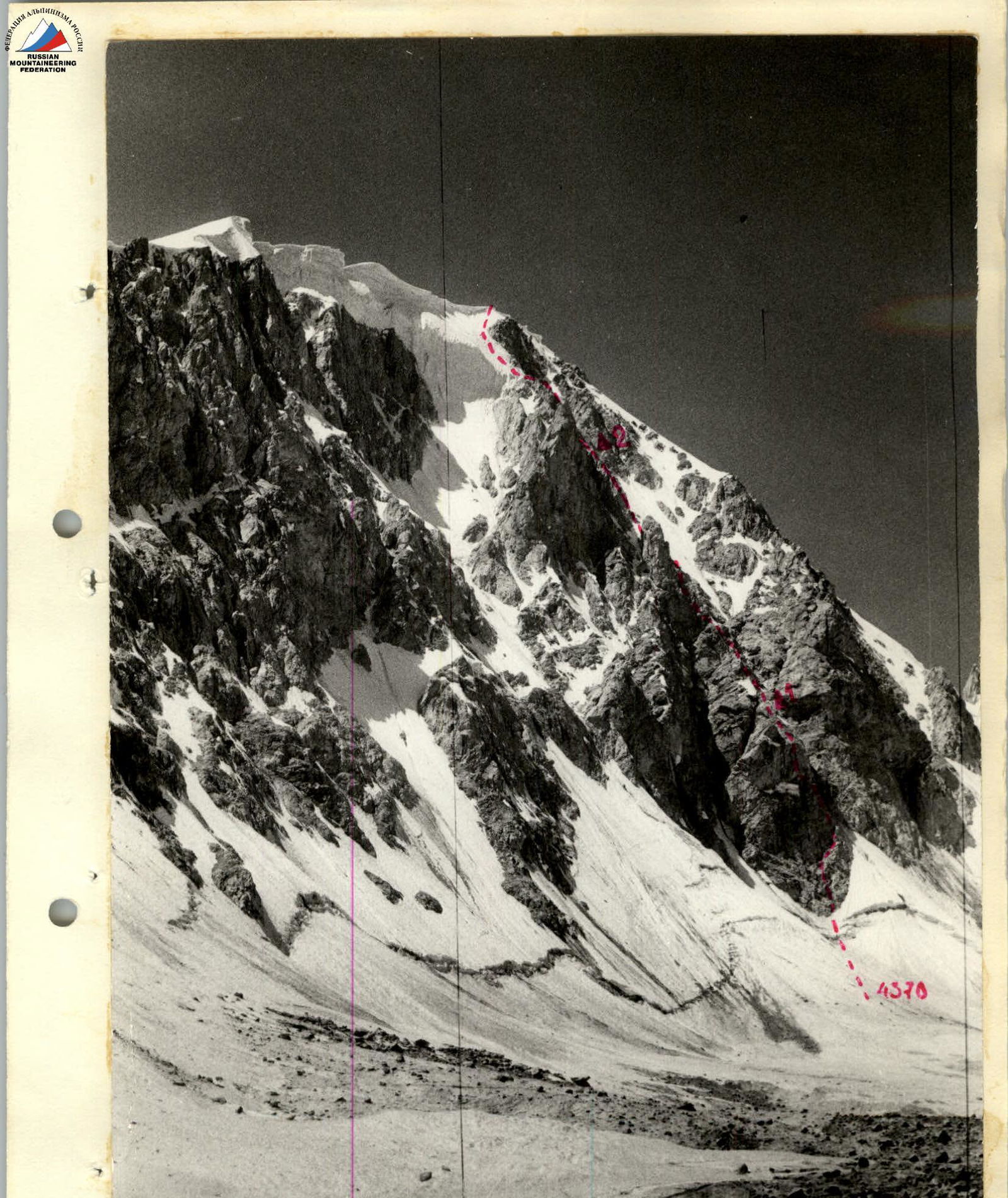
Photo 2: Profile of the NE wall of Peak Vodzh from the east. Taken from the glacier. Height — 4380 m. August 21, 1983, 13:00. Lens "Helios-44", f=58 mm.
 Right profile of the NE wall of Peak Vodzh. Taken from the summit of Gondorak on August 23, 1983 at 18:00 (5200). "Helios-44", f=58 mm.
Left profile of the NE wall of Peak Vodzh. Taken from the ridge of Peak 4971, — August 14, 1983 at 9:30 (4900). "Helios-44", f=58 mm.
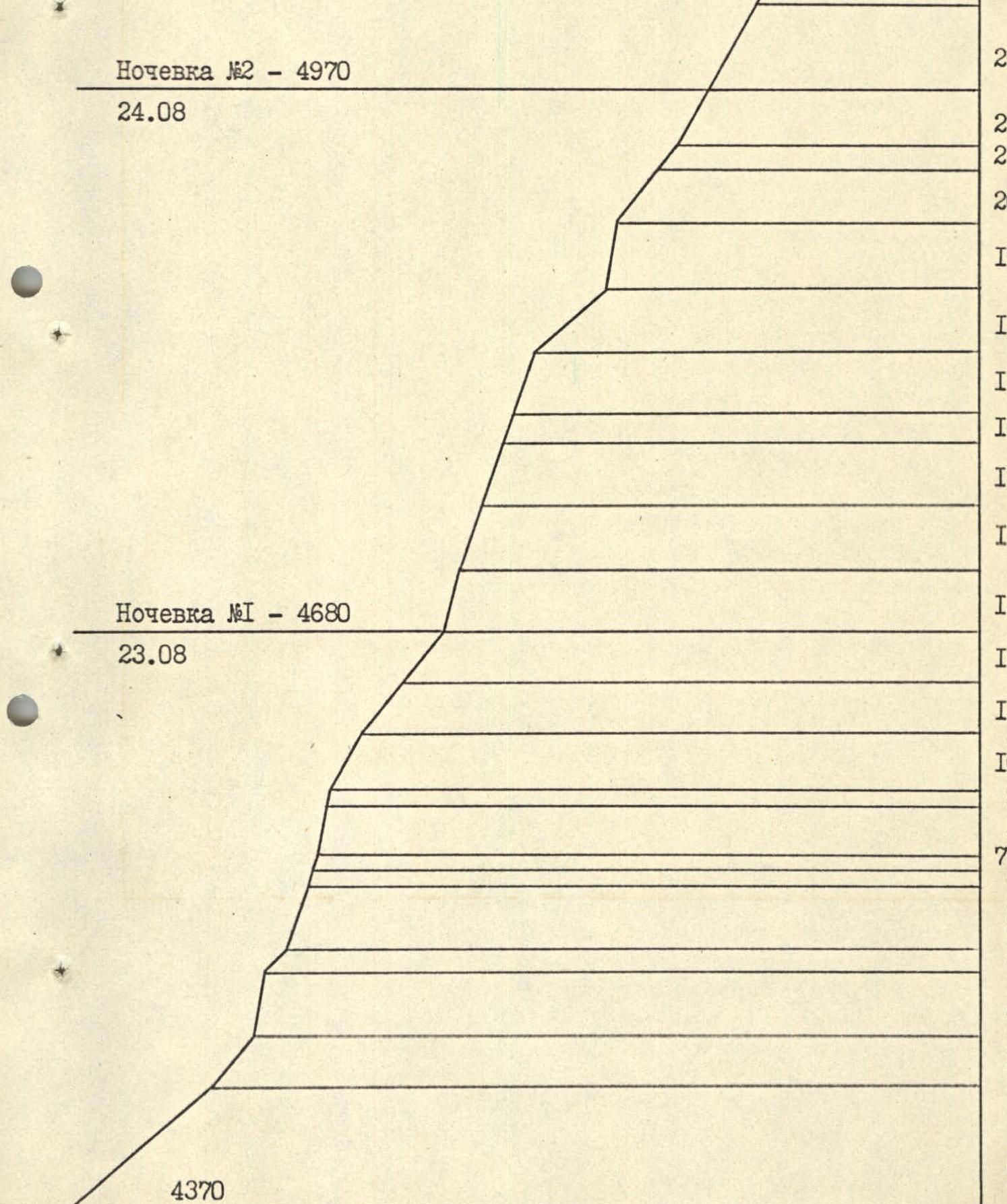
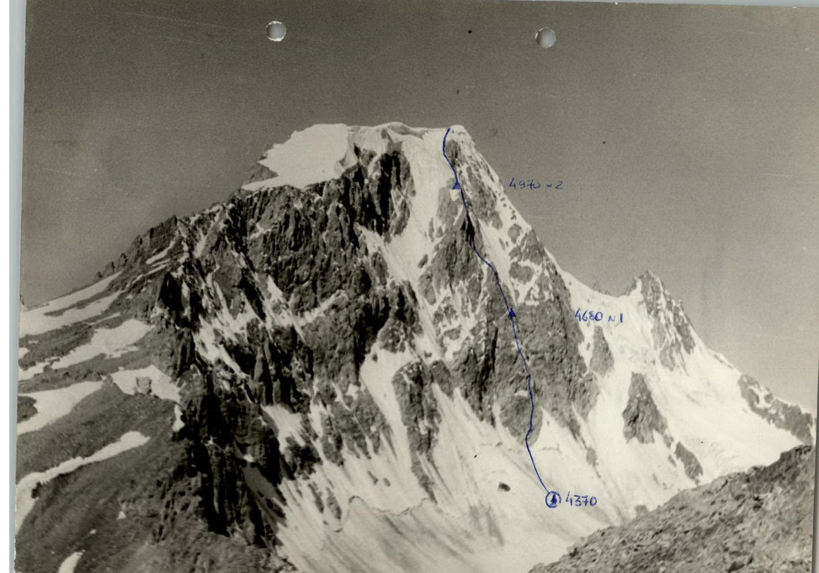
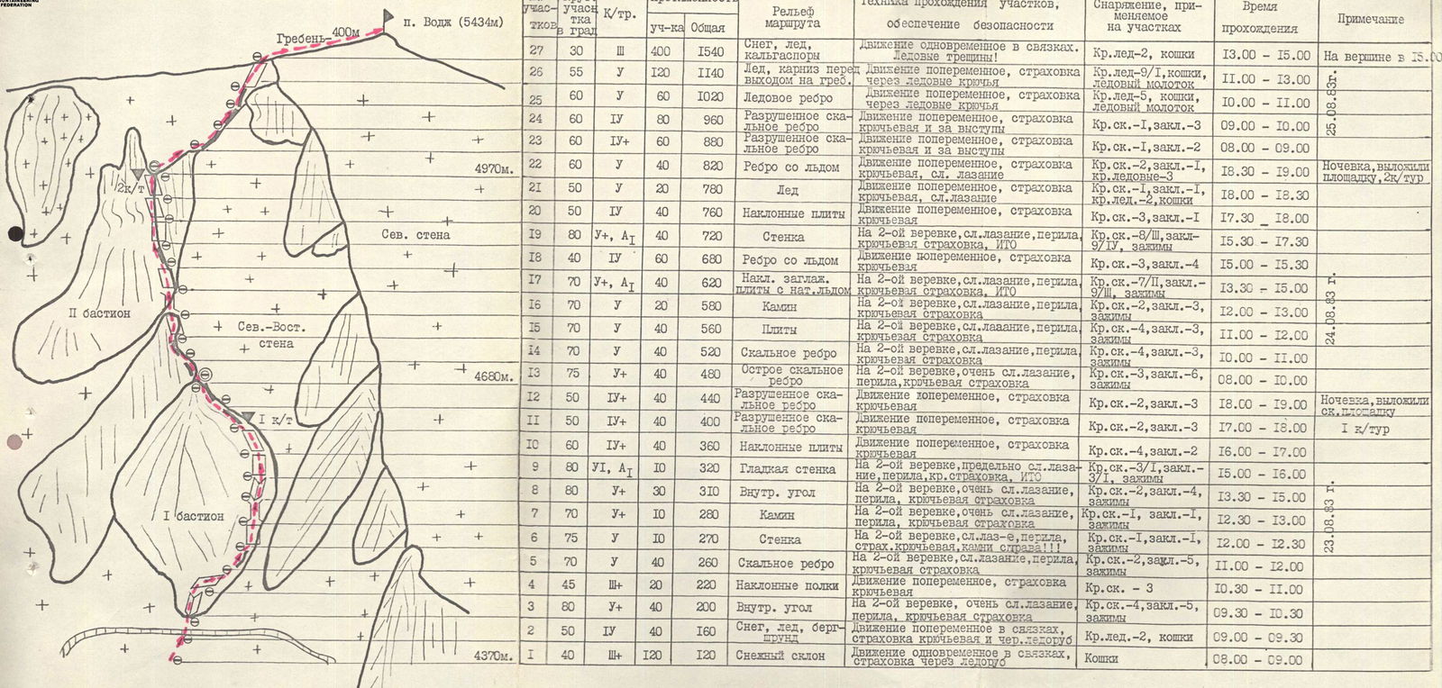
Route Profile (wall section — without the ridge)
Bivouac No. 2 — 4970 m, August 24 Bivouac No. 1 — 4680 m, August 23
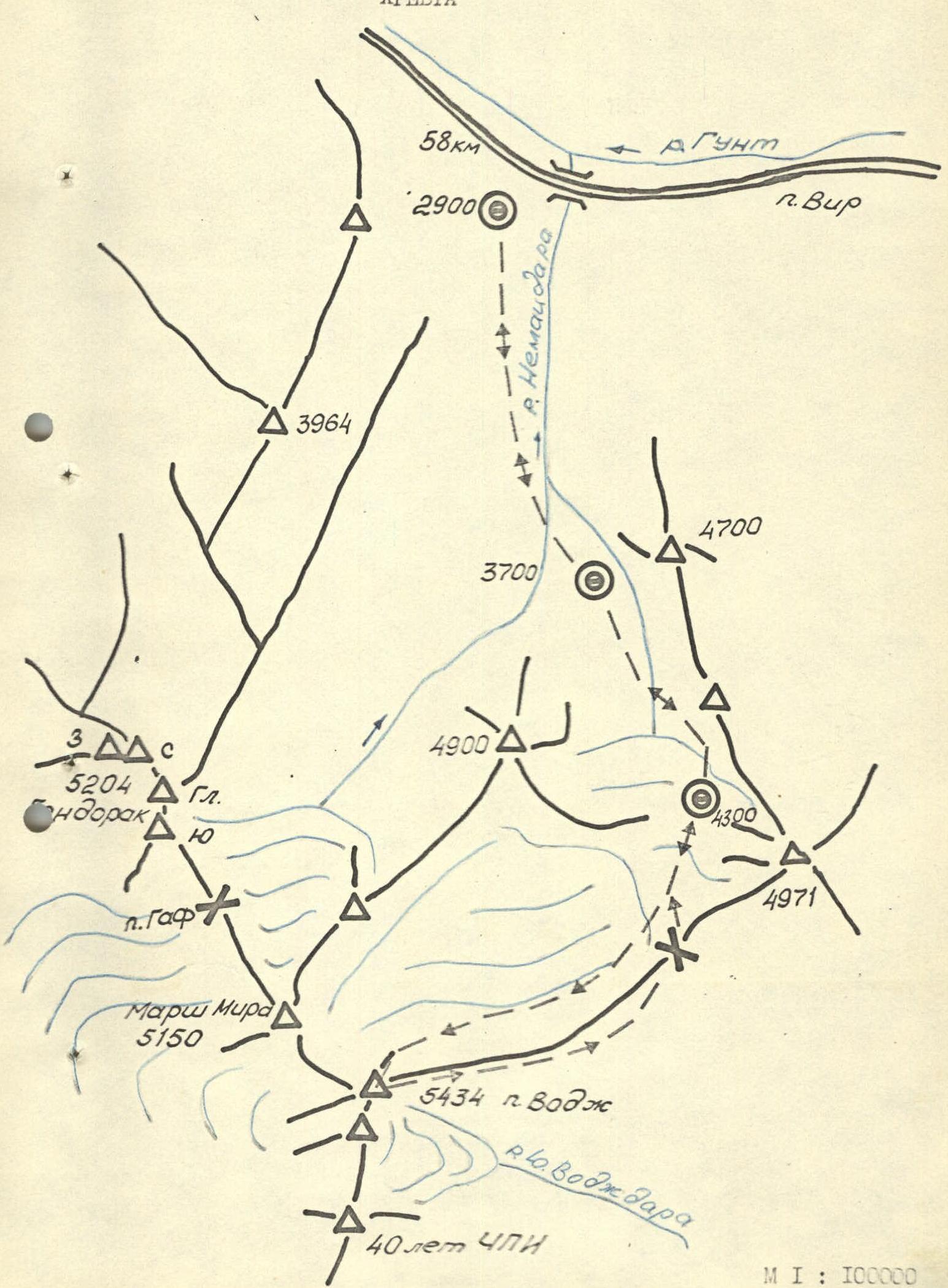
Scale Map of the North Shugnan Range
Brief Overview of the Ascent Area
This is the third region explored by Chelyabinsk climbers (1957–1966 — Karakol, 1975–1983 — Kyzylkiya).
Many know that the Chelyabinsk Regional Mountaineering Federation, in contact with the regional military commissariat, has established year-round training for conscripts serving on high-mountain outposts of our Motherland:
- Every year in winter and spring, 3-5 times they take recruits to the mountains
- In autumn, they send 300-350 of their trainees to the border troops
The work of Chelyabinsk mountaineers within the framework of contacts established with the topographic complex expedition No. 222 was equally extensive: for four years, the best athletes of the region ensured the success of correcting old topographic references from satellite images and some resurveys. They also explored the Shugnan Range but did not compile descriptions; the only exception was the group led by K. Vibralis, consisting of Lithuanian and Chelyabinsk mountaineers, which submitted descriptions of their first ascents from the south to Peaks Kaunas and Majoronas (1977).
Mountaineering exploration of the area began in the following year, 1978 — not by Chelyabinsk climbers, but by a powerful team from the "Alay" alpine camp led by V. Kavunenko and a friendly team from "Avangard," whose leader, Leopold Vsevolodovich Kensitsky, provided invaluable assistance during preparation, and MS P. Slavinsky shared descriptions.
Thanks to the efforts of these collectives, routes to peaks in the area between the villages of Vir and Vodzh were classified:
- Vir
- Gondorak
- DzheraIm
- Crystal
- Trapezia
- and others
We note inaccuracies in section 4.13 of the "Classification Table of Routes":
a) No. 2 "Gondorak 5A rock via the left edge of the N wall" and No. 7 "Gondorak West 5A rock via the counterfort of the N wall," climbed by A. Zybin (Moscow Spartak), — are the same combined route. The western peak of Gondorak, in our opinion, is not an independent peak (the saddle is small and not deep).
b) No. 13 "Majoronas" and No. 14 "5150" — are the same peak "5155," on which there is a topographic marker, disappointing the group of Odessans led by I. Orobei, who ascended the NW wall with the intention of naming the "unnamed peak" after the Heroes of Potemkin.
The approach to the area — through Osh to Dzhilandy and further to the village of Vir — 670 km. The second approach option: through Dushanbe-Khorog — 580 km, in our opinion, is less preferable, although it is shorter. The attached map clearly shows that the approaches in this area are clear and not large. From the base camp "2900," located in the willow grove on the western outskirts of the village of Vir, to the start of the route, the approach takes 5-5.5 hours and goes first up the Nemapdara River and further, bypassing Peak "4900" on the left, along the right (orographic) part of the glacier flowing from the northern slopes of Peak Vodzh.
Preparation for the Ascent
In preparation for the ascent, the following stages can be highlighted:
- Preliminary (correspondence) familiarization with the area using extensive photographic material and consultations with participants of the topographic complex expedition No. 222: Tarkhanov V.G., Sitchikhin D.V. As a result, Peak Vodzh (5434 m) via the counterfort of the NE wall was chosen as the main object of ascent, and Peak DzheraIm (5329 m) via the central counterfort of the E wall was chosen as a backup object.
- Physical and technical pre-trip training, including general physical, tactical, and special training within the framework of a constant year-round training cycle, participation in regional-scale climbing competitions.
Upon arrival in the Shugnan Range area:
- Conducting a training ascent on Peak "4971" via a 2B category route on August 15, 1983.
- Completing control standards for physical and technical training. Protocols are attached.
- First ascent on August 16, 1983, of a snow-ice route of 5A category on Peak Vodzh via the left edge of the N wall to familiarize themselves with the counterfort of the NE wall.
- Reconnaissance trip to the area of Peak DzheraIm from August 18 to 20, 1983, which revealed that the central counterfort of the E wall of Peak DzheraIm is relatively gentle and, although it can be visually assessed as 5A-5B category, it is significantly "weaker" than the counterfort of the NE wall of Peak Vodzh.
- Reconnaissance trip on August 21, 1983, under the northern slopes of Peak Vodzh to develop a final, detailed route plan, tactical ascent scheme, and photograph the route.
As a result of the reconnaissance, the following was clarified:
- The complexity of the chosen route meets the requirements for routes of 5B category.
- The route is combined and objectively safe.
- The couloirs to the left and right of the counterfort are exposed to rockfall and ice; avalanches are possible, especially at the beginning of summer. Therefore, an emergency descent from the route is only possible via the ascent route.
- There are two characteristic places on the route suitable for bivouac setup: at the top of the 1st and 2nd bastions.
- Monolithic rocks in the middle part of the 1st bastion and ice on the rocks in the upper part of the 2nd bastion could be problems on the route.
August 25, 1983. Sunny, warm. From 13:00, variable cloudiness.
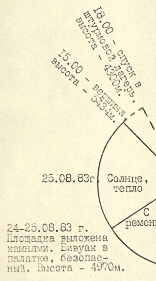
August 24-25, 1983. The platform is lined with stones. Safe bivouac in a tent. Height — 4970 m.
August 23, 1983. Sunny, warm. From 14:00, variable cloudiness. Wind.
August 23-24, 1983. The platform is carved into the ice and lined with stones. Safe bivouac in a tent under cover. Height — 4680 m.
Tactical Actions of the Team
The tactical plan drawn up before the ascent, based on reconnaissance results, included the following positions:
- Time schedule:
- August 22, 1983, 12:00 — departure from base camp "2900"
- 16:00 — arrival at the assault camp "4300," overnight stay
- August 23, 1983, 6:30 — departure from camp "4300"
- 8:00 — start working on the route
- 19:00 — passing the 1st bastion, stop for overnight stay
- August 24, 1983, 19:00 — passing the 2nd bastion, stop for overnight stay
- August 25, 1983, 13:00 — reaching the E ridge
- 15:00 — reaching the summit
- 18:00 — descending along the E ridge to camp "4300"
- August 26, 1983, 12:00 — descending to base camp "2900"
- Division into pairs:
- Kocherga Yu. — Mosiychuk I. — leading pair
- Kaigorodtsev S. — Shidlovsky S.
- The first climber in the leading pair works on a double rope on the wall section.
- Emergency descent from the wall section — via the ascent route.
- Each pair has its own individual first-aid kit.
- Radio communication with the base camp on even hours from 8:00 to 20:00
The planned tactical plan was largely executed, and there were no deviations from the movement schedule. On sections R3-R24, the first climber worked on a double rope. On complex sections (R3, R5-R9, R13-R17, R19), perches were organized, and climbers moved using jumar ascenders with top belay.
The first climbers in the leading pair alternated during the passage of key sections: Kocherga Yu. — sections R3, R8, R9, R13, R15, R16, R19; Mosiychuk I. — R5-R7, R14, R17. Starting from section R25, the leading pair was changed. Gear was transported using a shuttle system.
On August 23 and 24, at 13:00, a short break was taken for a snack (canned fish, lard, condensed milk). Each team member had pocket food during the ascent (chocolate, dried fruits).
Both bivouacs on the route were in tents, with platforms made of stone. Radio communication with the base camp and observers was stable and timely, with no missed communication sessions. There were no falls or injuries on the route.
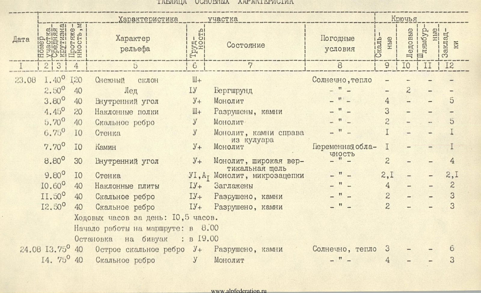
Table of Main Characteristics
| Date | Section No., Angle | Length, m | Terrain Characteristics | Difficulty | Condition | Weather Conditions | Rock Pits | Ice Pits | Bolt Pits | Chocks |
|---|---|---|---|---|---|---|---|---|---|---|
| August 23 | R1. 40° | 120 | Snow slope | 1+ | Sunny, warm | — | — | — | — | |
| R2. 50° | 40 | Ice | 4 | Bergschrund | — | — | 2 | — | — | |
| R3. 80° | 40 | Inner corner | 5+ | Monolith | " | 4 | — | — | 2 | |
| R4. 45° | 20 | Inclined ledges | 1+ | Destroyed, rocks | " | 3 | — | — | 5 | |
| R5. 70° | 40 | Rock rib | 5 | Monolith | " | 2 | — | — | — | |
| R6. 75° | 10 | Wall | 5 | Monolith, rocks from couloir on the right | " | 1 | — | — | 1 | |
| R7. 70° | 10 | Chimney | 5+ | Monolith | Variable cloudiness | 1 | — | — | 4 | |
| R8. 80° | 30 | Inner corner | 5+ | Monolith, wide vertical slot | " | 2 | — | — | 2,1 | |
| R9. 80° | 10 | Wall | 5, A1 | Monolith, micro-grips | " | 2,1 | — | — | 2 | |
| R10. 60° | 40 | Inclined slabs | 4+ | Smoothed | " | 4 | — | — | 3 | |
| R11. 50° | 40 | Rock rib | 4+ | Destroyed, rocks | " | 2 | — | — | 2 | |
| R12. 50° | 40 | Rock rib | 4+ | Destroyed, rocks | " | 2 | — | — | — | |
| Walking hours for the day: | 10.5 h. | |||||||||
| Start of work on the route: | 8:00 | |||||||||
| Stop for bivouac: | 19:00 | |||||||||
| August 24 | R13. 75° | 40 | Sharp rock rib | 5+ | Destroyed, rocks | Sunny, warm | 3 | — | — | 6 |
| R14. 75° | 40 | Rock rib | 5 | Monolith | " | 4 | — | — | 3 | |
| R15. 70° | 40 | Inclined slabs | 5 | Monolith | " | 4 | — | — | 3 | |
| R16. 70° | 20 | Chimney | 5 | Monolith | " | 2 | — | — | 3 | |
| R17. 70° | 40 | Inclined slabs | 5+, A1 | Smoothed, covered with ice | Variable cloudiness | 5, 11 | — | — | 6, 11 | |
| R18. 40° | 60 | Rock rib | 4 | Ice, rocks | " | 3 | — | — | 4 | |
| R19. 80° | 40 | Wall | 5+, A1 | Monolith, small grips | " | 5, 1Y | — | — | 5, 1Y | |
| R20. 50° | 40 | Inclined slabs | 4 | Monolith | " | 3 | — | — | 1 | |
| R21. 50° | 20 | Ice with rock islands | 5 | Rocks from islands | " | 1 | 2 | — | 1 | |
| R22. 60° | 40 | Rock rib | 5 | Ice | " | 2 | 3 | — | 1 | |
| Walking hours for the day: | 10.5 h. | |||||||||
| Departure from bivouac on 1st bastion: | 8:00 | |||||||||
| Stop for bivouac under 2nd bastion: | 19:00 | |||||||||
| August 25 | R23. 60° | 60 | Rock rib | 4+ | Heavily destroyed | Sunny, warm | 1 | — | — | 2 |
| R24. 60° | 80 | Rock rib | 4 | Destroyed | " | 1 | — | — | 3 | |
| R25. 60° | 60 | Ice rib | 5 | " | — | 5 | — | — | ||
| R26. 55° | 120 | Ice slope | 5 | Cornice before reaching E ridge | " | — | 8, 1 | — | — | |
| R27. 30° | 400 | Snow-ice ridge, corniced | 3 | " | — | 2 | — | — | ||
| Walking hours to the summit: | 7.0 h. | |||||||||
| Departure from bivouac: | 8:00 | |||||||||
| Reaching the summit of Peak Vodzh: | 15:00 | |||||||||
| Start of descent from the summit: | 15:30 | Descent along E ridge through the saddle between Peak Vodzh and Peak 4971 to assault camp "4300" — 18:00 |
Equipment Table
| No. | Name | Quantity (pcs.), Total weight (kg) | Used on sections |
|---|---|---|---|
| 1. | Main rope 40 m | 2, 4.5 | R1-R27 |
| 2. | Main rope 80 m | 1, 4.5 | R1-R27 |
| 3. | Auxiliary rope 20 m | 1, 0.8 | — |
| 4. | Belay harness + harness | 4, 1.2 | R1-R27 |
| 5. | Jumar ascenders | 6, 0.5 | R3, R7-R9, R13-R17, R19 |
| 6. | Carabiners | 30, 2.25 | R1-R27 |
| 7. | Rock hooks, wedges, boxes | 23, 1.5 | R3-R24 |
| 8. | Ice hooks (ice screws) | 5, 0.4 | R2, R21, R22, R25-R27 |
| 9. | Bolt | 1, 0.2 | — |
| 10. | Bolt hooks | 15, 0.2 | — |
| 11. | Chock elements | 3 sets, 1.5 | R3-R24 |
| 12. | Rock hammers | 3, 2.4 | R3-R24 |
| 13. | Ice hammer | 1, 0.8 | R25, R26 |
| 14. | Ice axes | 4, 4.0 | R1, R2, R25-R27 |
| 15. | Ladder | 2, 0.1 | R9, R17, R19 |
| 16. | Crampons | 4 pairs, 2.8 | R1, R2, R21, R25-R27 |
| 17. | Protective helmets | 4, 2.0 | R1-R27 |
| 18. | Down jackets | 4, 2.8 | on bivouacs |
| 19. | "Zibram" boots | 4 pairs, 6.0 | R1-R27 |
| 20. | Galoshes | 1 pair, 0.4 | R3, R7-R9, R13-R17, R19 |
| 21. | Descent loops | 4, 0.8 | — |
| 22. | Self-belay loops | 4, 0.6 | R1-R27 |
| 23. | Extension loops | 6, 0.3 | R3-R24 |
| 24. | Down sleeping bags | 2, 2.0 | on bivouacs |
| 25. | Down "leg" | 2, 1.0 | on bivouacs |
| 26. | "Pamirka" tent | 1, 4.0 | on bivouacs |
| 27. | Cape-raincoat | 2, 0.3 | — |
| 28. | Primus stove | 1, 1.0 | on bivouacs |
| 29. | Gasoline | 2 liters, 1.8 | on bivouacs |
| 30. | Pot | 1, 0.3 | on bivouacs |
| 31. | Radio station | 1, 0.8 | during communication |
| 32. | First-aid kit | 2, 0.8 | — |
| 33. | Camera | 1, 1.0 | |
| 34. | Backpacks | 4, 2.0 | R1-R27 |
| 35. | Mats | 2, 0.4 | on bivouacs |
| 36. | Electric flashlight | 1, 0.1 | on bivouacs |
| 37. | Personal items | 4 kits, 4.0 | |
| Total: | 60.15 kg |
List of Products Taken on the Route
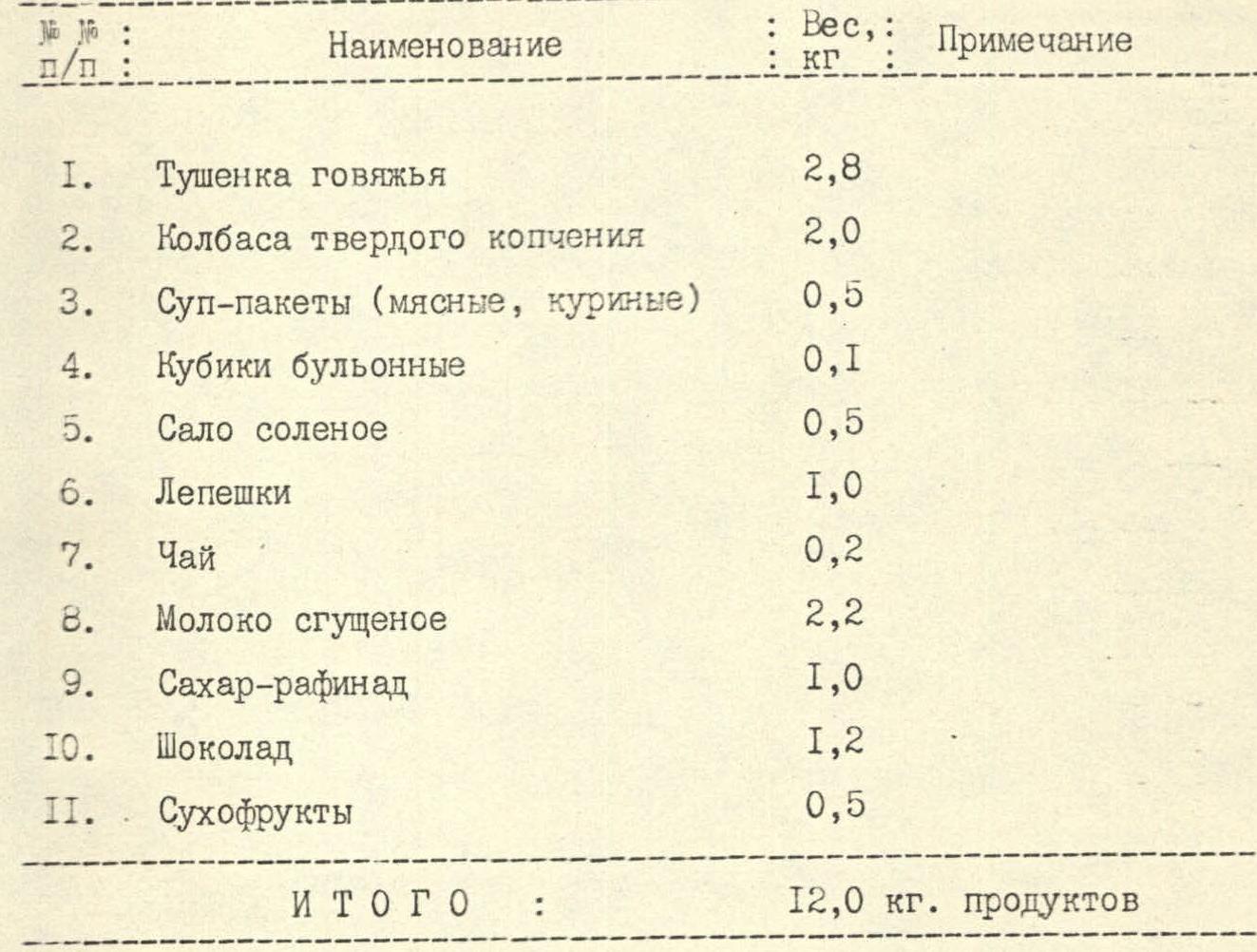
| No. | Name | Weight, kg | Note |
|---|---|---|---|
| 1. | Canned beef | 2.8 | |
| 2. | Hard-smoked sausage | 2.0 | |
| 3. | Soup packs (meat, chicken) | 0.5 | |
| 4. | Bouillon cubes | 0.1 | |
| 5. | Salted lard | 0.5 | |
| 6. | Flatbread | 1.0 | |
| 7. | Tea | 0.2 | |
| 8. | Condensed milk | 2.2 | |
| 9. | Sugar cubes | 1.0 | |
| 10. | Chocolate | 1.2 | |
| 11. | Dried fruits | 0.5 | |
| Total: | 12.0 kg | products |
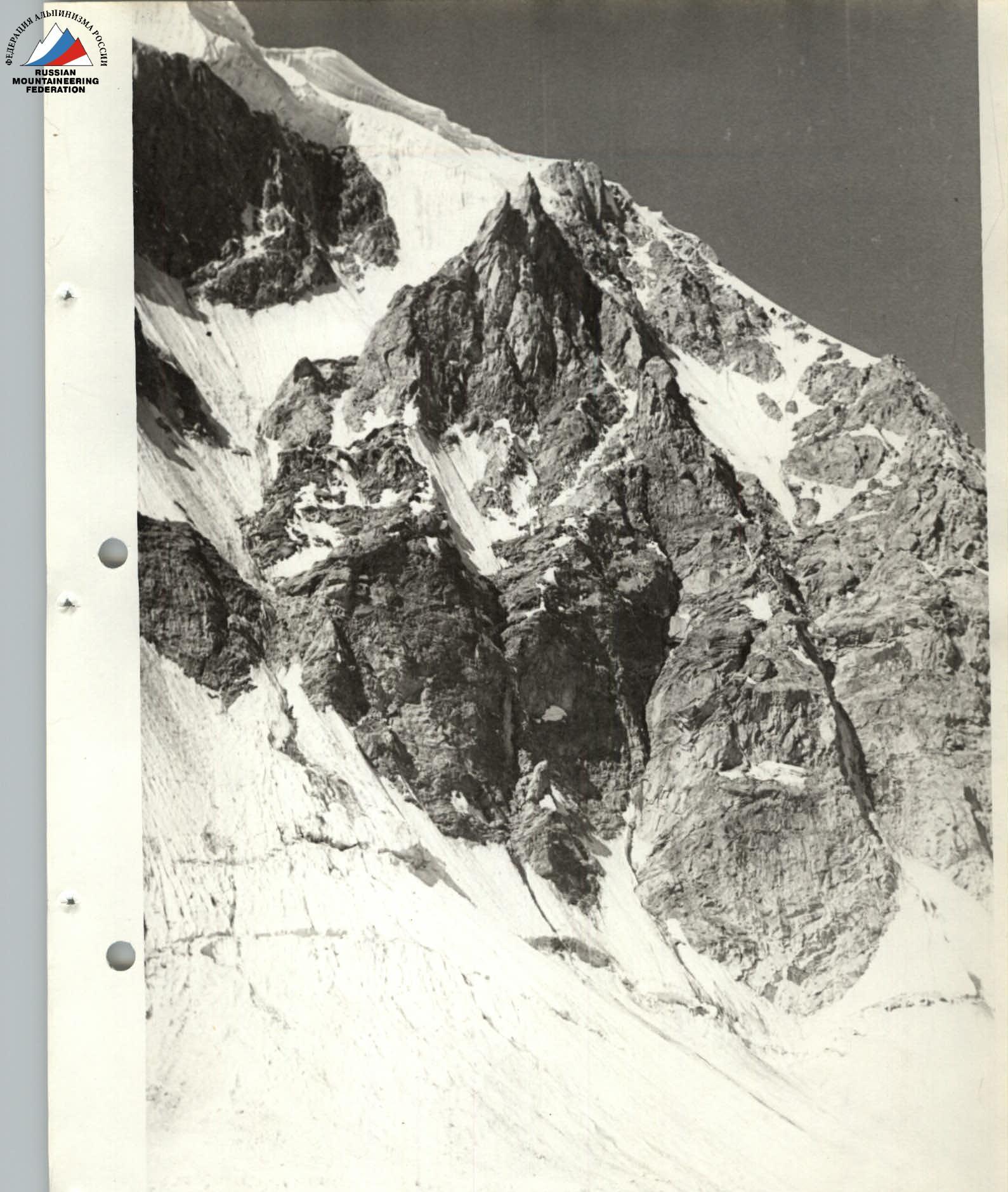
Photo 1: General view of the route.
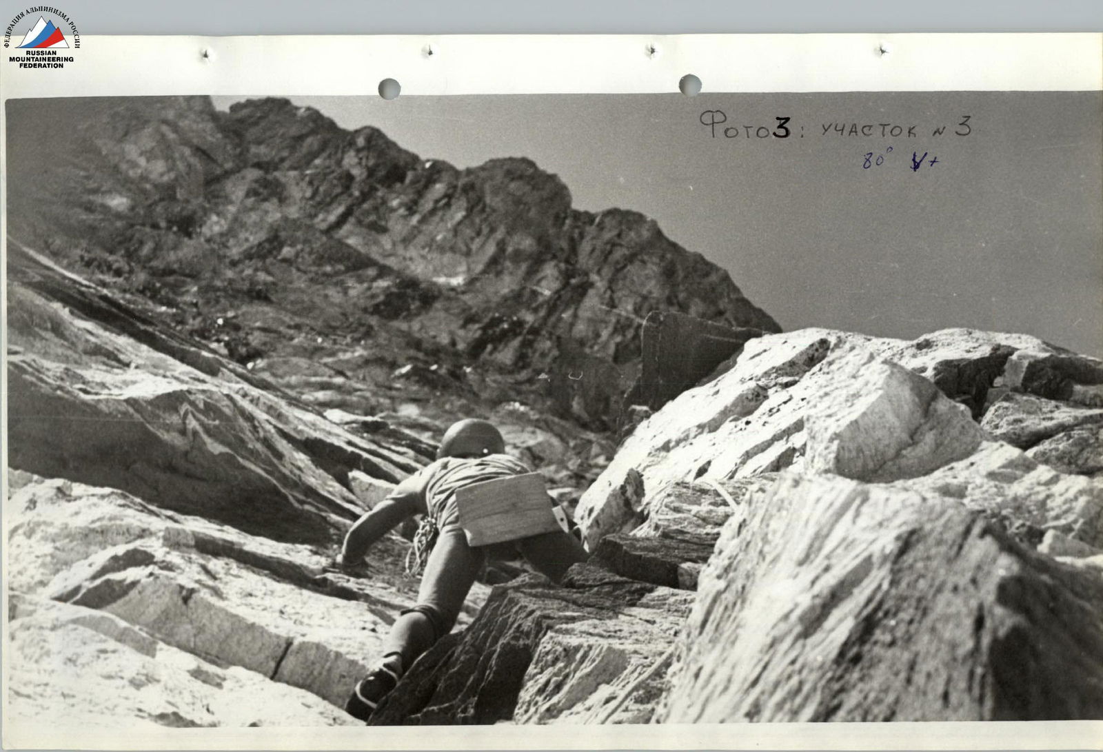
Photo 3: Section R3. 80°, 5+.

Photo 4: Section R9 (upper part). 80°, 5, A1.
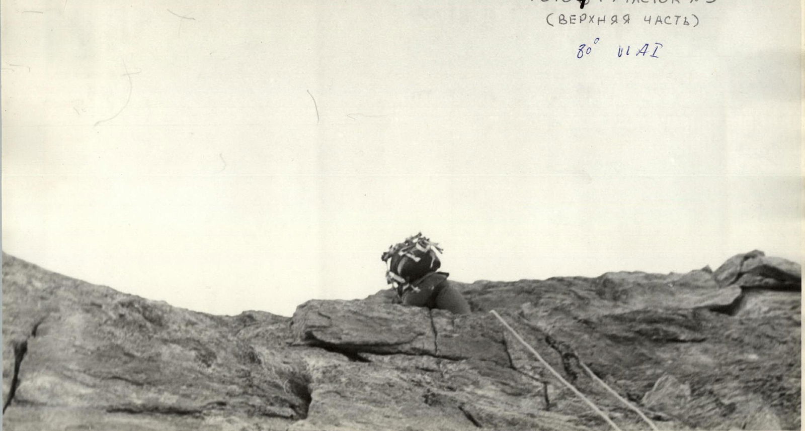
Photo 5: Sections R16-R17. 70°, A1, 5+.
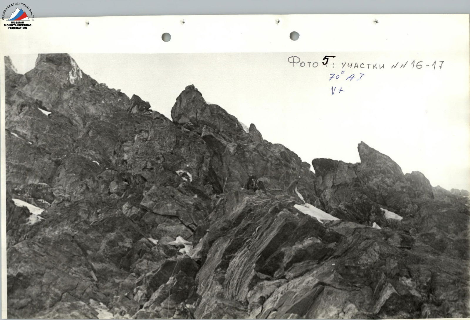
Photo 6: Section R17. 70°, 5+, A1.
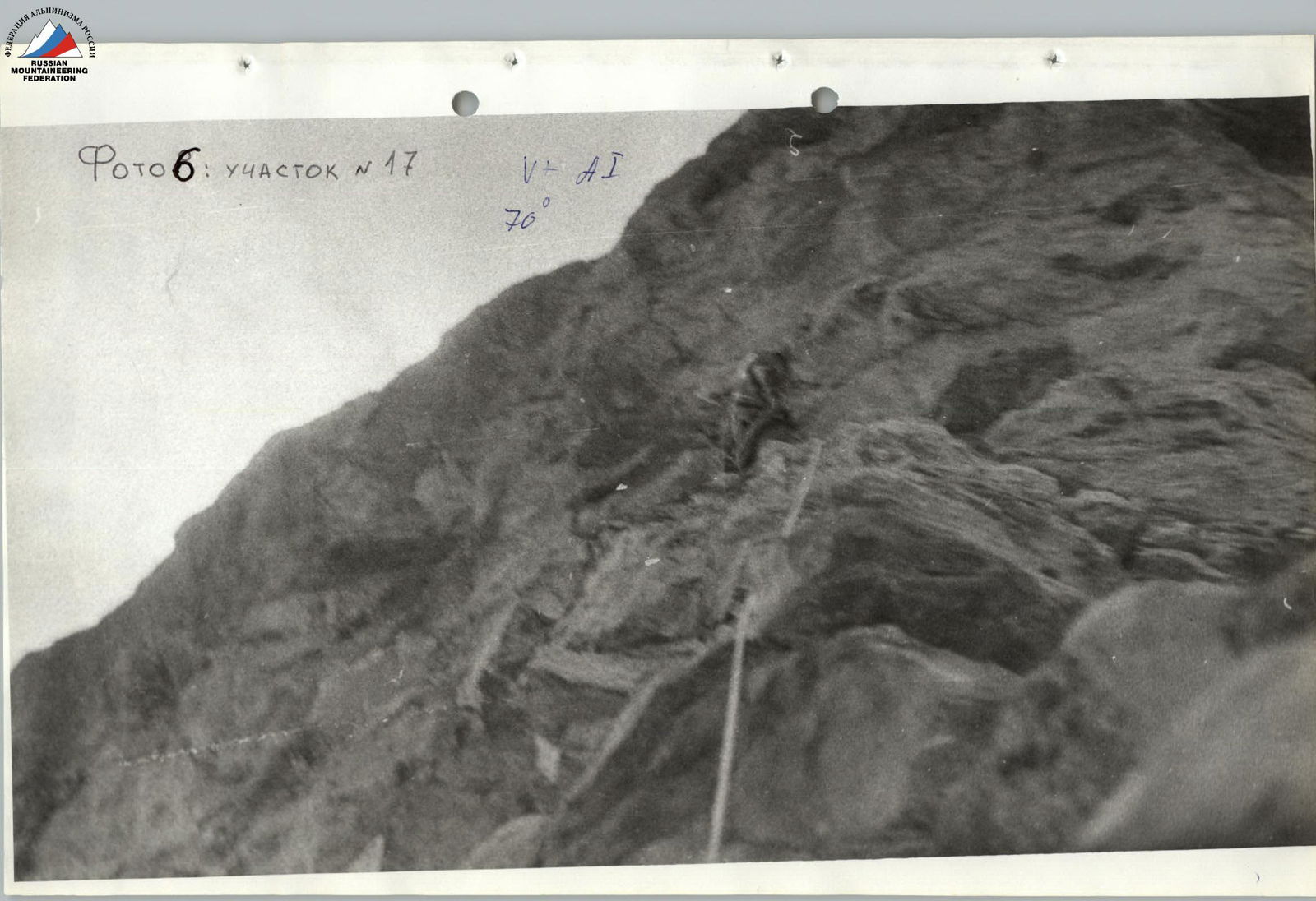
Photo 7: Section R19 (lower part). 5+, A1.
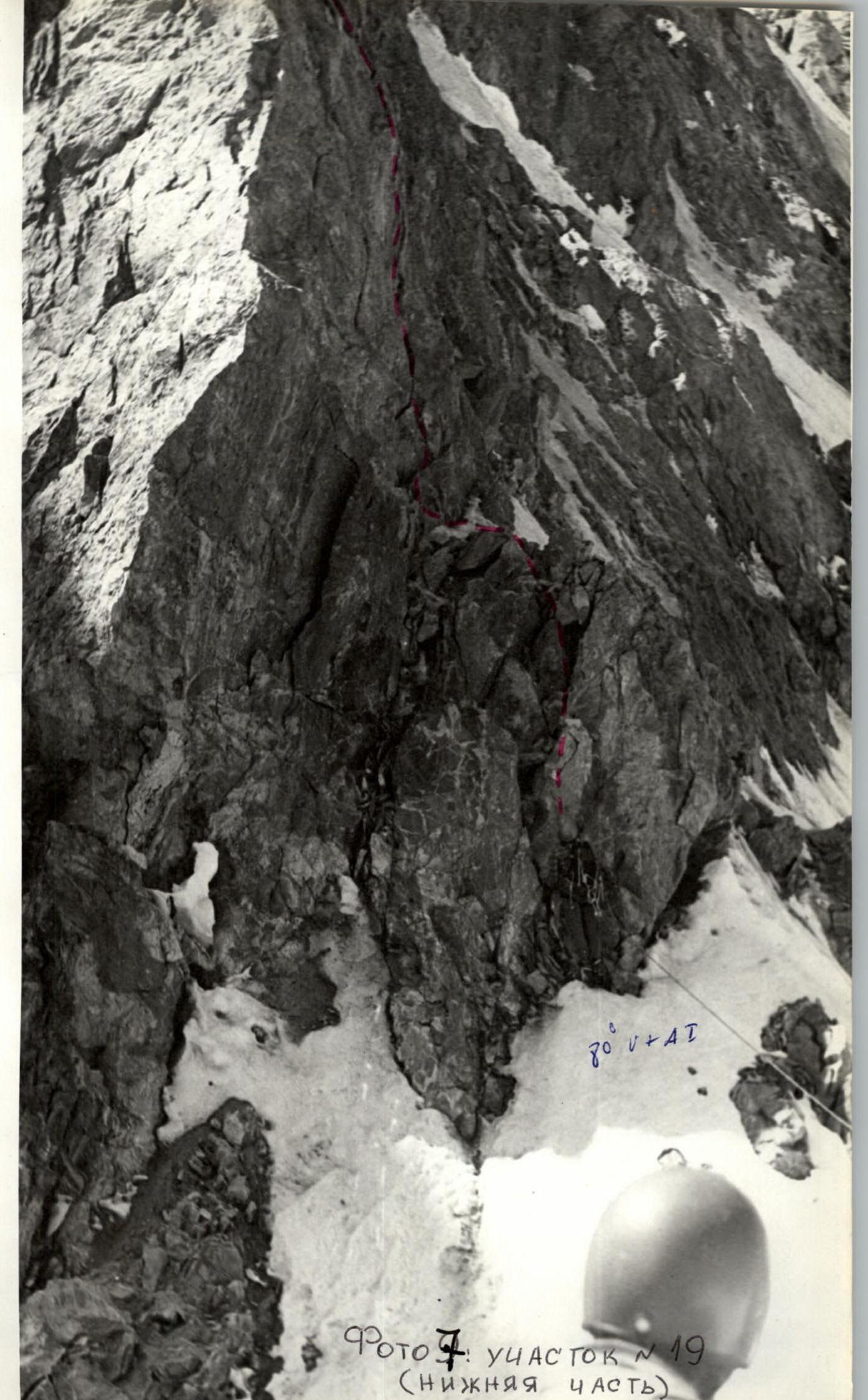
Photo 8: Section R19 (upper part).
Photo 9: Sections R23-R24. 60°, 4+.

Photo 10: View of the E ridge to the left of the route.
 ![img-30.jpeg]({"width":180,"height":165,"format
Comments
Sign in to leave a comment