Ascent Passport
- Ascent class – technical
- Ascent area – Pamir, Yazgulemsky Ridge
- Peak, its height, and ascent route – p. 5700 m, from Gantman's Pass along the SW ridge
- Proposed difficulty category – 3A combined
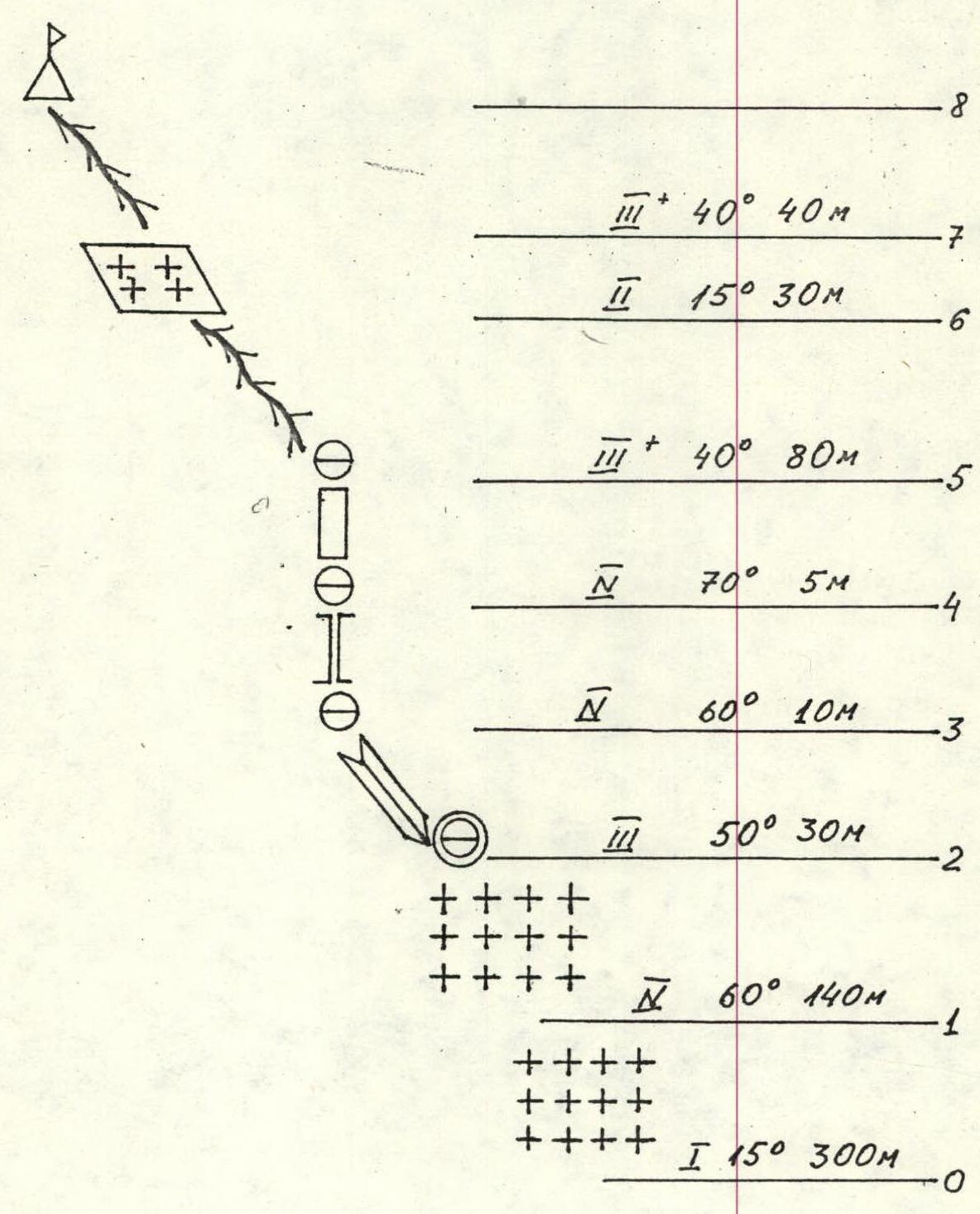
- Route characteristics: height difference – 450 m, average steepness – 30°, section lengths – R1–300 m; R2–280 m; R3–328 m; R4–80 m
- Number of pitons for protection: for creating belays
- rock – 6
- ice – 31
- Number of travel hours – 6 hours
- Number of overnight stays – 0
- Full name of the leader and participants, their sports qualification:
- Hansen Kalle Rikhardovich – 2nd sports category
- Lykhmuс Alfred Alfredovich – 2nd sports category
- Team coach – Priymets Ilmar
- Date of departure for the route and return – August 18, 1984
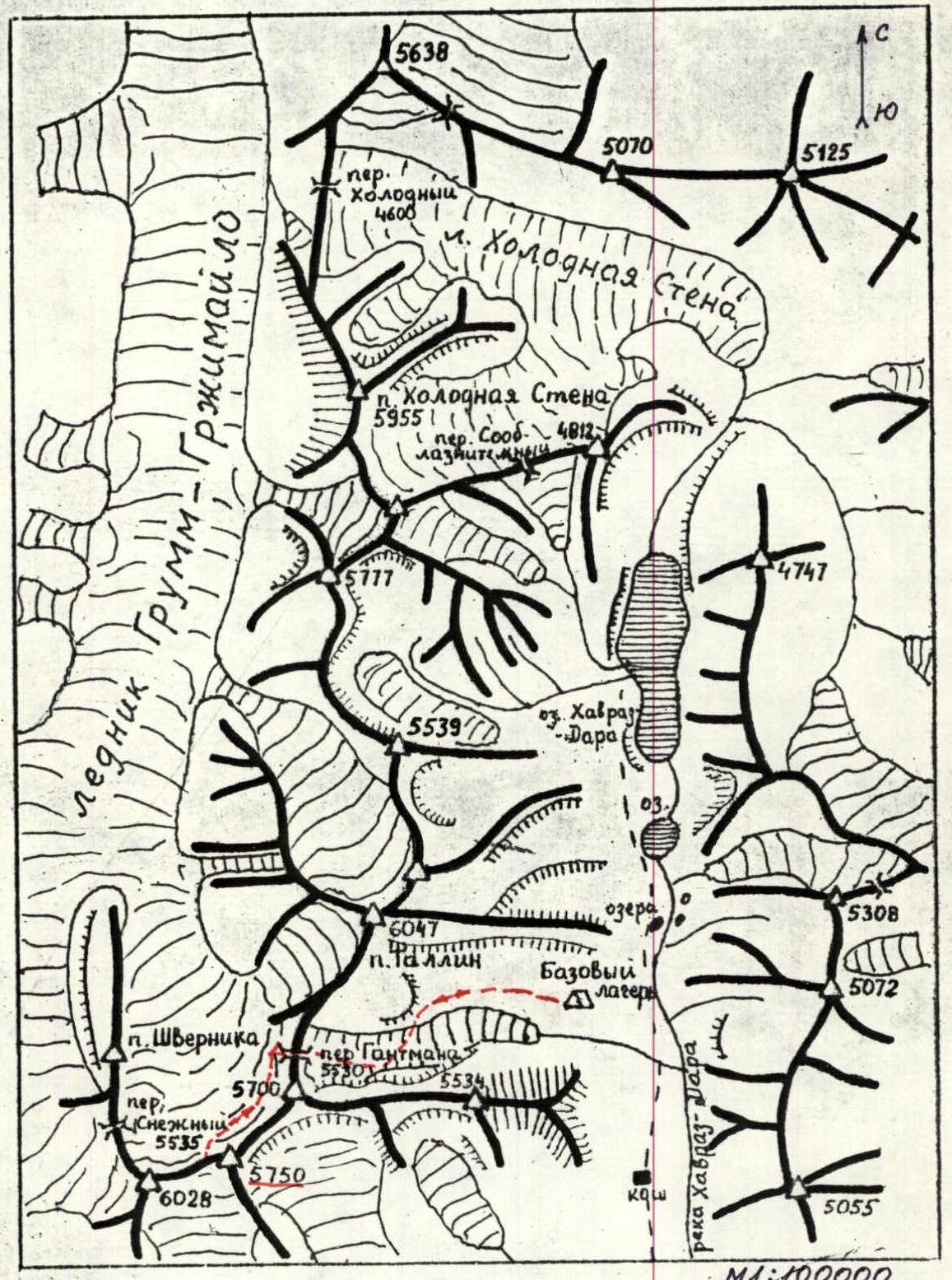
Scheme of the area of peak 6047 m
Central Pamir, Yazgulemsky Ridge
Approach to the route
There are two options for approaching the SW ridge of peak 5750 m:
- from the North via Gantman's Pass;
- from the South
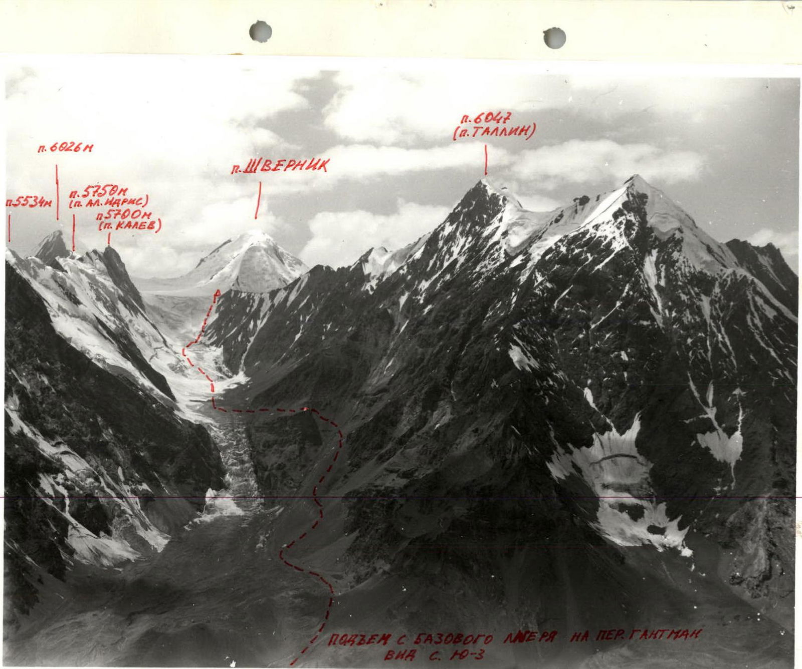
The base camp is located near the terminal moraine of Gantman's Glacier at an altitude of 3900 m. From the base camp to the first icefall, we walked along the left-bank (orogr.) moraine. Further, we could move in two ways:
- alongside the icefall on the left bank (orogr.) or
- bypassing the rocky spur next to the icefall on the right, along the talus slope, which leads above the icefall to the glacier.
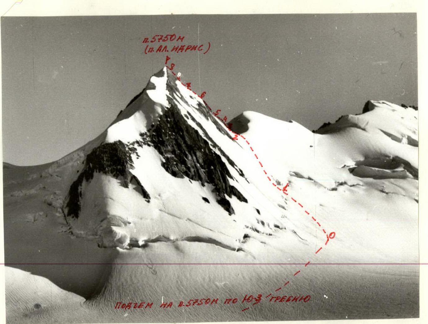
We followed the second option. Travel time from the base camp to the glacier was 2 hours 30 minutes. In the flat part, the glacier is open. The second icefall is traversed in its lower part, in the center, and then along the steep part, it is traversed on the right, up to Gantman's Pass. Travel time for crossing the upper icefall was 3 hours. From Gantman's Pass (5330), the entire ascent route is visible, and it takes 50 minutes to walk to the start of the route from the pass across the closed glacier. The approach to the ridge from the south is along the moraine and the open glacier to the rocky wall with a height difference of 200–1000 m and a steepness of 70–80°, which leads to the SW ridge of p. 5750 m.
TABLE OF MAIN CHARACTERISTICS OF THE ASCENT ROUTE
| Date | Designation | Average steepness in degrees | Length in m | Terrain character | Difficulty | Condition | Weather conditions | Rock Pitons | Ice Pitons | Bolt Pitons | Notes |
|---|---|---|---|---|---|---|---|---|---|---|---|
| 20.08.1984 departure from the bivouac at Gantman's Pass at 7:30 | R0–R1 | 15 | 300 | Snow slope | 1 | good | |||||
| R1–R2 | 60 | 140 | Ice slope | 4 | –"– | 18 | bergschrund | ||||
| R2–R3 | 50 | 30 | Rocky inner corner | 3 | destroyed | –"– | 5 | ||||
| R3–R4 | 60 | 10 | Rocky stones | 4 | –"– | –"– | 3 | ||||
| R4–R5 | 70 | 5 | Rocky wall | 4 | –"– | –"– | 3 | ||||
| R5–R6 | 40 | 80 | Rocky ridge | 3 | –"– | –"– | ledges | ||||
| R6–R7 | 15 | 30 | Ice slope | 2 | –"– | –"– | |||||
| R7–R8 | 40 | 40 | Rocky ridge | 3 | –"– | –"– | ledges | ||||
| R8–R0 | descent via the ascent route |
UIAA Scheme p. 5750 m (peak "Al. Idris")
p. 5750 m (peak "Al. Idris"). Ascent to p. 5750 m along the SW ridge.
p. 6047 (p. Tallinn), p. 6026 m, p. 5534 m, p. 5750 m (peak "Al. Idris"), p. 5700 m (p. Kalev), p. Shvernik. Ascent from the base camp to Gantman's Pass, view from the SW.