ASCENT DOCUMENT
I. Ascent class: High-altitude technical
2. Ascent area: Pamir, eastern spurs of the Yazgulemsky Ridge
3. Peak, its height, route: Kholodnaya стена, 5979 m, via the center of the North face
4. Difficulty category: 6B
5. Route characteristics:
- Height difference: 1500 m
- Length of sections:
- 6th category difficulty: 760 m
- 5th category difficulty: 860 m
- Average steepness of the wall section of the route: 76° (4470–5900 m)
6. Pitons driven:
- for belaying:
- rock: 135
- ice: 52
- bolt: 2
- chocks: 128
- for creating artificial anchors:
- rock: 24
- ice: 2
- bolt: —
- chocks: 12
7. Number of climbing hours (excluding approach and descent): 89 hours, 8 days
8. Number of bivouacs and their characteristics: 5 lying, 2 sitting
- (1, 2, 3, 6, 7 bivouacs) — lying
- (4 and 5 bivouacs) — sitting
9. Surname, name, patronymic of the leader, participants, and their qualification:
- Stadnik Vladimir Fedorovich — Master of Sports
- Khoroshilov Alexander Afanasievich — Candidate Master of Sports
- Sedov Vladimir Ivanovich — Candidate Master of Sports
- Grebennikov Alexander Andreevich — Candidate Master of Sports
- Bezverkhy Alexander Igorevich — Candidate Master of Sports
10. Team coach: Stadnik V. F. — Master of Sports of the USSR
11. Date of departure on the route: July 25
12. Date of return from the route: August 1
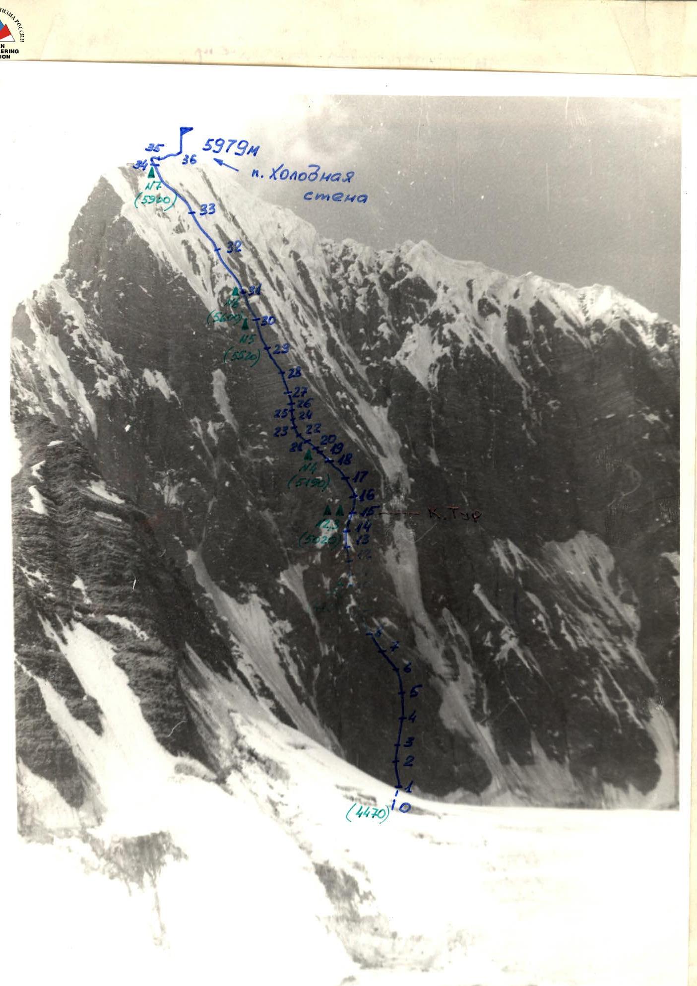
General view of the wall. MiR-1 (37 mm), distance 2 km, height 4500 m.
Preliminary Preparation
The physical and tactical preparation of the ascent participants was based on joint, long-term, year-round training in Kiev and the mountains. Training sessions were conducted four times a week at the sports complex "Temp". At the end of each month, all team members took physical fitness tests.
Rock climbing techniques were practiced in rock climbing labs near the village of Deneshy, in gravel pit quarries, and in Crimea.
During general physical training, the main focus was on developing:
- long-term endurance in climbers (running 20–25 km distances);
- endurance to dynamic and static loads (pull-ups, push-ups, weightlifting, football, basketball).
In rock climbing labs, in addition to individual climbing, the team practiced working with ropes, techniques for overcoming complex vertical sections and cornices, and ascending with backpacks on fixed ropes. Particular attention was given to:
- tactics for navigating complex routes;
- team interaction;
- testing special equipment;
- organizing bivouacs on sheer walls.
In 1984, Stadnik V., Sedov V., and Grebennikov A. completed joint ascents to Peak Iskander via the South face (V. Grishchenko's route) — 5B category difficulty, and to Peak TTU via the counterfort of the Southeast face (V. Solonnikov's route) — 6B category difficulty, which were recognized as the best in the Technical Class Championship of the CS DSO "Zenit" and the High-Altitude Technical Class Championship of the Ukrainian SSR, respectively.
In 1985, during a training cycle, the team made a joint ascent via a route of approximately 3B category difficulty.
Before ascending Peak Kholodnaya стена (July 24), the team observed the North face, studied the ascent route, potential bivouac sites, tactics for navigating the route, and the timing and intensity of falling rocks and ice.
Tactical Ascent Plan
July 24 — observing the route. Departure from the assault camp under the North face is planned for July 25. The route is expected to be completed in 8 days (excluding approach and descent).
| № | Description |
|---|---|
| 1 | Day — traversing the ice slope under the wall and the 1st rock bastion. Section (R0–R11). |
| 2 | Day — traversing the snow-ice counterfort and reaching under the second rock bastion, which is the central part of the wall. Section (R11–R16). |
| 3 | Day — processing the lower part of the second bastion. Section (R16–R20). |
| 4 | Day — processing the central part of the second bastion. Section (R20–R25). |
| 5 | Day — traversing the upper part of the second bastion, reaching the top of the second bastion. Section (R25–R30). |
6–7 day — traversing the snow-ice counterfort with "mushrooms" and the ice slope leading to the East ridge. Section (R30–R34). 8 day — reaching the summit of Kholodnaya стена. Section (R34–R36). 9 day — descending from the summit to the assault camp. 10 day — reserve day in case of bad weather.
The tactics for navigating the route stem from the team's experience on previous complex wall routes. The main elements are:
- the first climber ascends on a double rope without a backpack;
- on rocks, climbers wear galoshes, and on snow and ice, they wear crampons.
To ensure the first climber's safety in case of a fall, an absorber with a breaking force of 400 kg is used. The second climber provides belay for the first, while the third brings up the remaining necessary equipment.
The fourth and fifth team members dismantle the fixed ropes and pass equipment up. Ropes are always double. Backpacks are carried by climbers either on their shoulders or attached to their harnesses via extenders.
Given the limited number of convenient bivouac sites and the need to maximize daylight hours, the team plans to process the route above the bivouacs. The group is equipped with the necessary amount of equipment (see "Equipment Table").
Radio communication between the assault group, observation group, and base is maintained using "Vitalka" and "Karat" radios.
In case of sudden weather deterioration, the group will "sit it out" at one of the bivouacs. With prolonged bad weather or an emergency, the team will descend via the ascent route.
For nutrition on the route, individual food packs are prepared. Hot meals are prepared on bivouacs, morning and evening.
Route Navigation Order (see ascent analysis)
Conclusion and Route Recommendations
The route to Peak Kholodnaya стена via the center of the North face is technically very complex and combined.
According to the participants, the route corresponds to the 6B category difficulty in all respects.
This route is more challenging than all previously completed 6B category routes by the team:
- Bodkhona
- Nakhar
- Zindon
- TTU
This route has the following features
- A significant part of the route (rock sections) has a steepness of about 80°, with some sections being even steeper. The upper part of the second bastion has many overhanging sections.
- Rocks along the entire route section are heavily fragmented, creating additional challenges during ascent. The rocks are composed of large blocks. Particular caution is required when organizing anchor points and belay stations.
- Belaying on most rock sections was done using chocks and pitons. The team used bolt pitons left on the route by A. Verba's team. Two of their own bolt pitons were driven.
- The ice in the upper part of the route is very difficult to traverse. Extensive work with ice axes is required. The ice wall at the beginning of the route is also challenging.
- Bivouacs on the route were mostly organized on "mushrooms" and snow ridges, with a few rock ledges. The locations of bivouacs are described in the route description. Organizing bivouacs in other locations is problematic.
- The ascent was conducted in good weather throughout.
- The route demands excellent physical, technical, and psychological preparation from the team members.
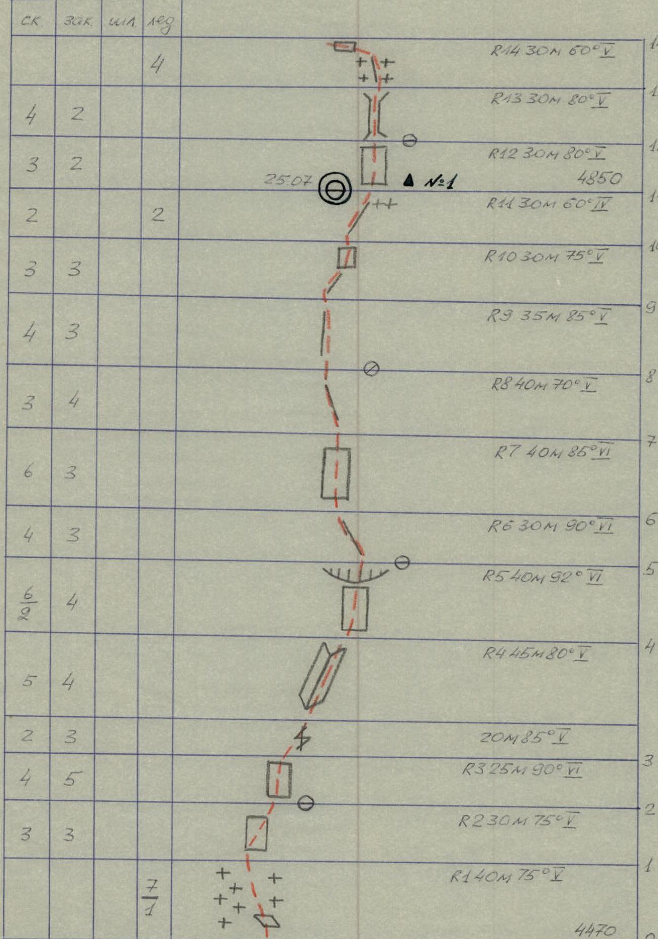
Route Diagram in M 1:2000 Symbols
| Section | ROCK | CHOCK | BOLT | ICE | Description | Notes |
|---|---|---|---|---|---|---|
| R0 | — | — | — | — | Start, 4470 m | |
| R1 | 7 | — | — | 1 | 40 m, 75° I | |
| R2 | 3 | — | — | 3 | 30 m, 75° I | |
| R3 | 4 | — | — | 5 | 25 m, 90° VI | |
| R4 | 5 | — | — | 4 | 45 m, 80° IV | |
| R5 | 6 | — | — | 2 | 40 m, 92° VI | |
| R6 | 4 | — | — | 3 | 30 m, 90° VI | |
| R7 | 6 | — | — | 3 | 40 m, 85° VI | |
| R8 | 3 | — | — | 4 | 40 m, 70° V | |
| R9 | 4 | — | — | 3 | 35 m, 85° V | |
| R10 | 3 | — | — | 3 | 30 m, 75° I | |
| R11 | 2 | — | — | 2 | 30 m, 60° IV | 25.07, ▲N№1, 4850 m |
| R12 | 3 | — | — | 2 | 30 m, 80° I | |
| R13 | 4 | — | — | 2 | 30 m, 80° I | |
| R14 | 4 | — | — | — | 30 m, 60° IV | |
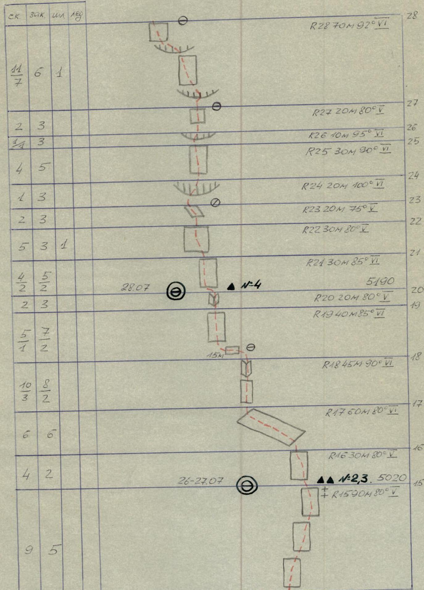
| R15 | 9 | 5 | — | — | 90 m, 80° V | 26–27.07, ▲N№2,3, 5020 m |
| R16 | 6 | 6 | — | — | 30 m, 80° I | |
| R17 | — | — | — | — | 60 m, 80° VI | |
| R18 | 10 | 3 | — | 2 | 45 m, 90° VI | 15 m below R19 |
| R19 | 5 | 7 | — | 1 | 40 m, 85° VI | |
| R20 | 2 | 3 | — | — | 20 m, 80° V | |
| R21 | 4 | 2 | — | 2 | 30 m, 85° VI | 28.07, ▲N№4, 5190 m |
| R22 | 5 | 3 | — | 1 | 30 m, 80° V | |
| R23 | 2 | 3 | — | — | 20 m, 75° V | |
| R24 | 1 | 3 | — | — | 20 m, 100° VI | |
| R25 | 4 | 5 | — | — | 30 m, 90° VI | |
| R26 | 3 | 3 | — | — | 10 m, 95° VI | |
| R27 | 2 | 3 | — | — | 20 m, 80° V | |
| R28 | 11 | 7 | — | 1 | 70 m, 92° VI | |
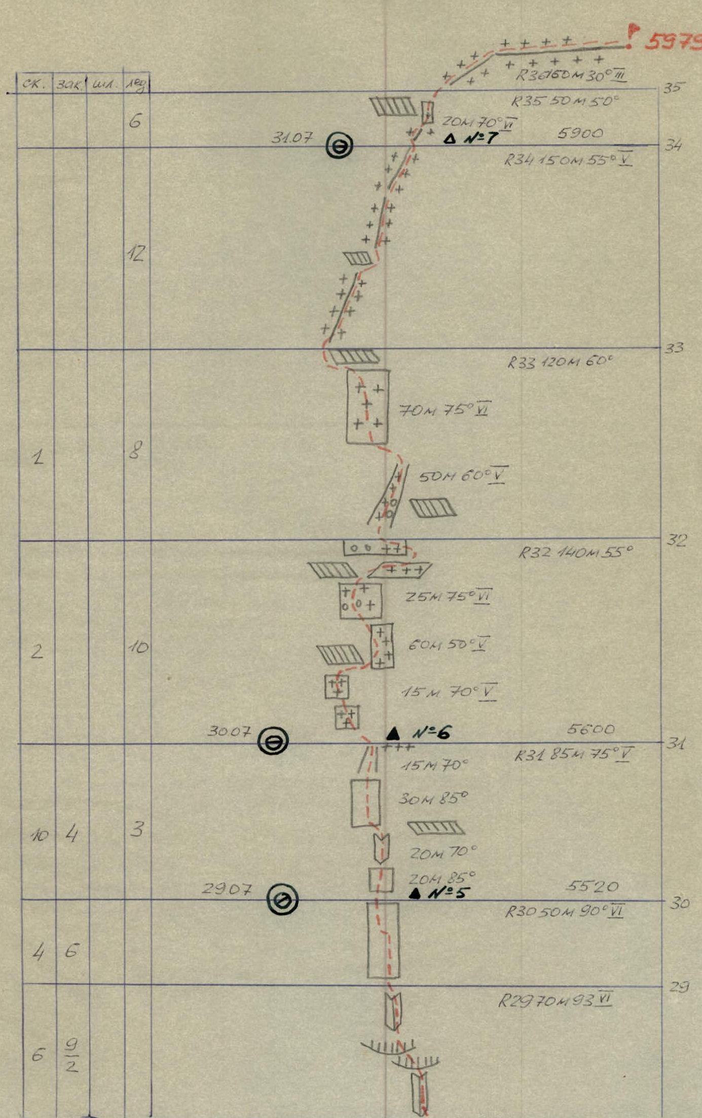
| R29 | 6 | — | — | 2 | 70 m, 93° VI | 29.07, ▲N№5, 5520 m |
| R30 | 4 | 6 | — | — | 50 m, 90° VI | |
| R31 | 10 | 4 | — | 3 | 85 m, 75° V | 30.07, ▲N№6, 5600 m |
| R32 | — | — | — | — | 140 m, 55° I | |
| R33 | 12 | — | — | — | 120 m, 60° V | |
| R34 | 2 | — | 8 | — | 150 m, 55° V | 31.07, ▲N№7, 5900 m |
| R35 | — | — | — | — | 50 m, 50° I | |
| R36 | 6 | — | — | — | 160 m, 30° III | Summit, 5979 m |