59а
1. Ascent Passport
- High-altitude technical climb
- Pamir, eastern spurs of Yazgulemsky Ridge, Khavraz-Dara valley
- Peak Kholodnaya Stena via the central bastion of the north face
- Proposed 5B category of complexity, first ascent
- Wall section height difference: 1260 m, length: 1450 m. Total height difference: 1500 m, total length: 2000 m. Length of sections with 5–6 category of complexity: 830 m. Average steepness of main sections: 74° (5000–5650 m), including 280 m of 6th category complexity.
- Pitons used: Rock pitons – 82, ice screws – 39, chocks – 62, bolt hanger pitons – (dash)
- Total climbing hours – 39, total days – 4
- Night bivouacs: 1st and 2nd on a suspended platform, 3rd on a ridge saddle during descent
- Team leader: Boyko Valery Viktorovich – Master of Sports Team members: Martynov Leonid Borisovich – Candidate Master of Sports Kolobaev Sergey Petrovich – Candidate Master of Sports Levchenko Alexander Nikolaevich – Candidate Master of Sports
- Coach: Korsun Anatoly Grigorievich
- Start of the ascent: August 13, 1985 Summit: August 15, 1985 Descent to base camp: August 16, 1985
General photo of the summit
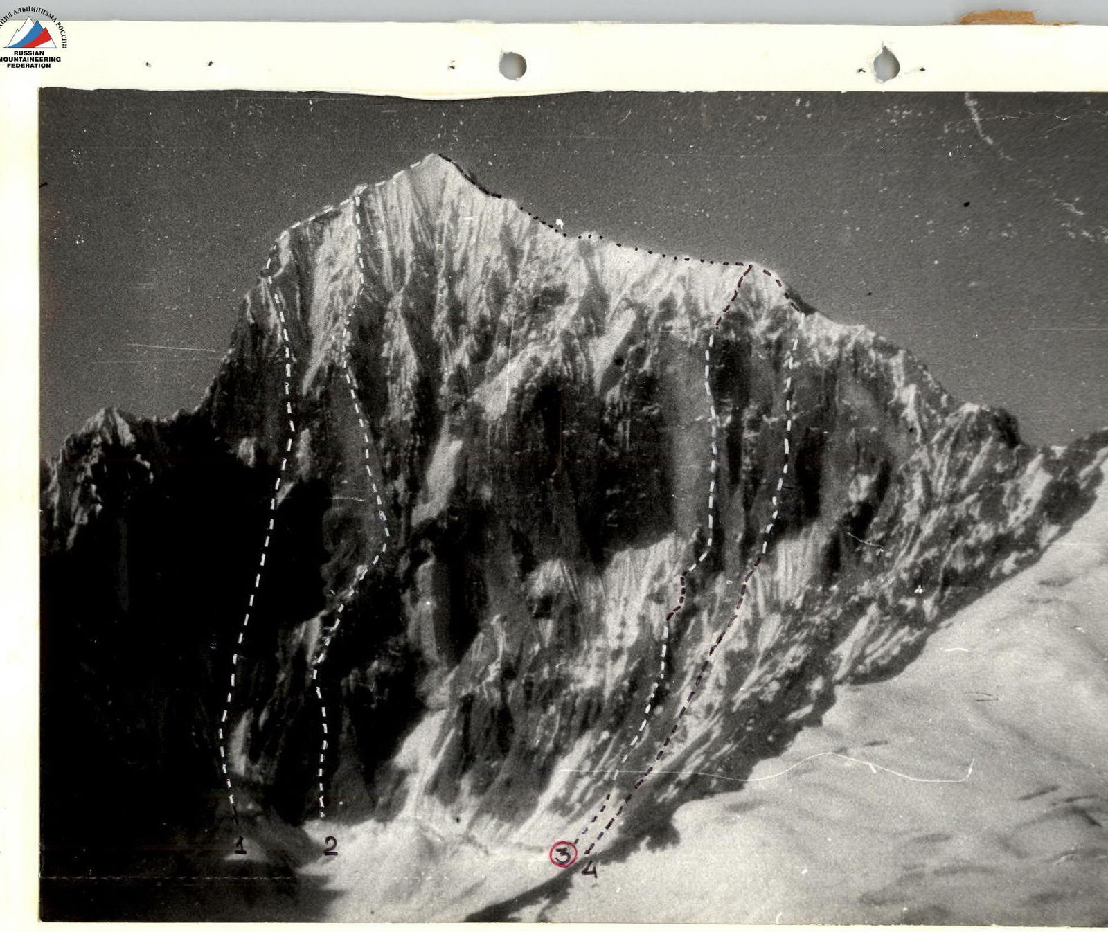
August 4, shot point #3. Height ~5000 m, distance ~5 km. Legend: 1 – Kolomyitsev (1983, 6th category of complexity) 2 – Verba (1983, 6th category of complexity) 3 – Boyko (1985, first ascent) 4 – Klineckii (1983, 5B category of complexity) Prev. Bastion S.
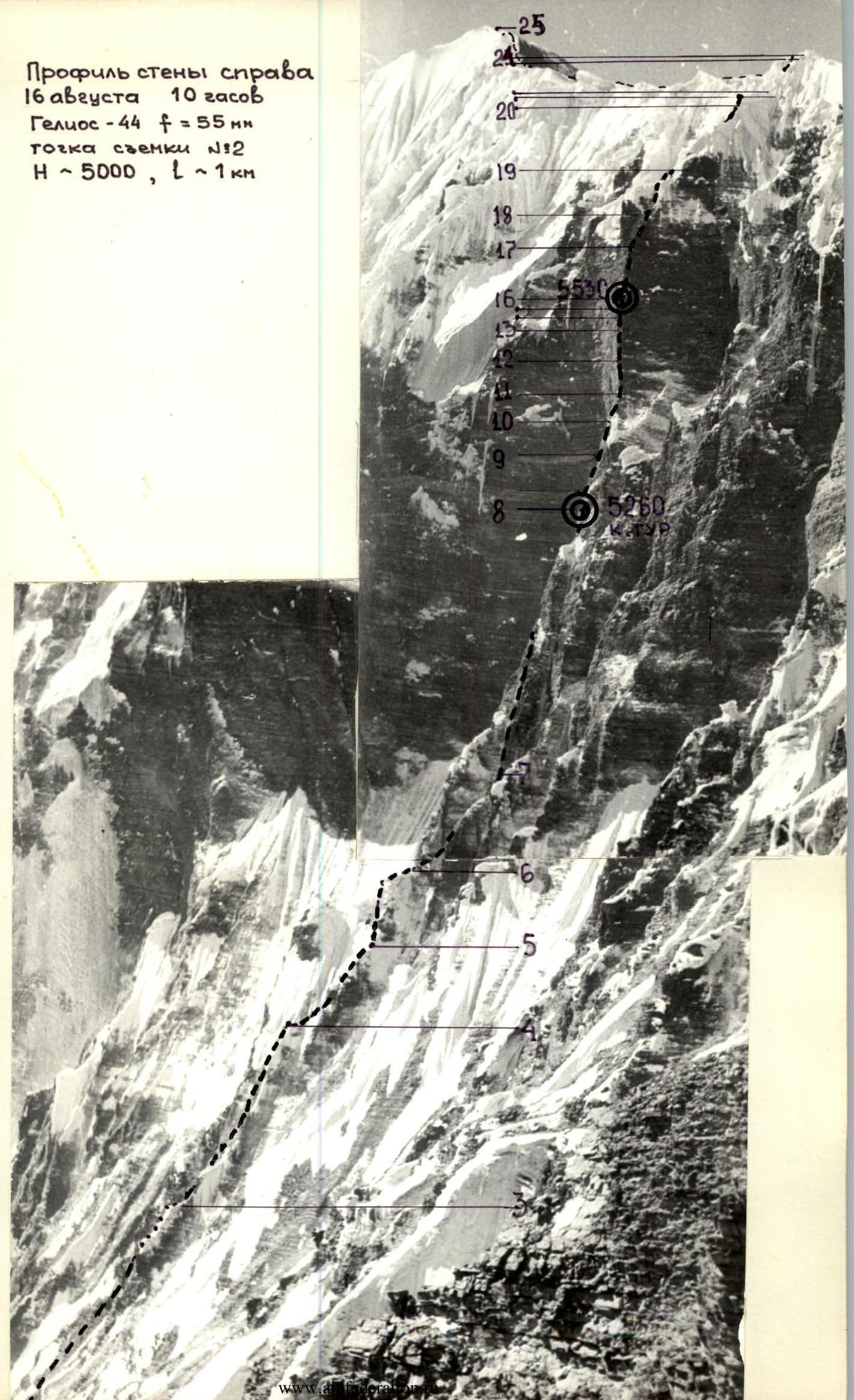
Profile of the wall from the right
August 16, 10 hours. Helios-44, f = 55 mm. Shot point #2. H ~ 5000 m, L ~ 1 km.
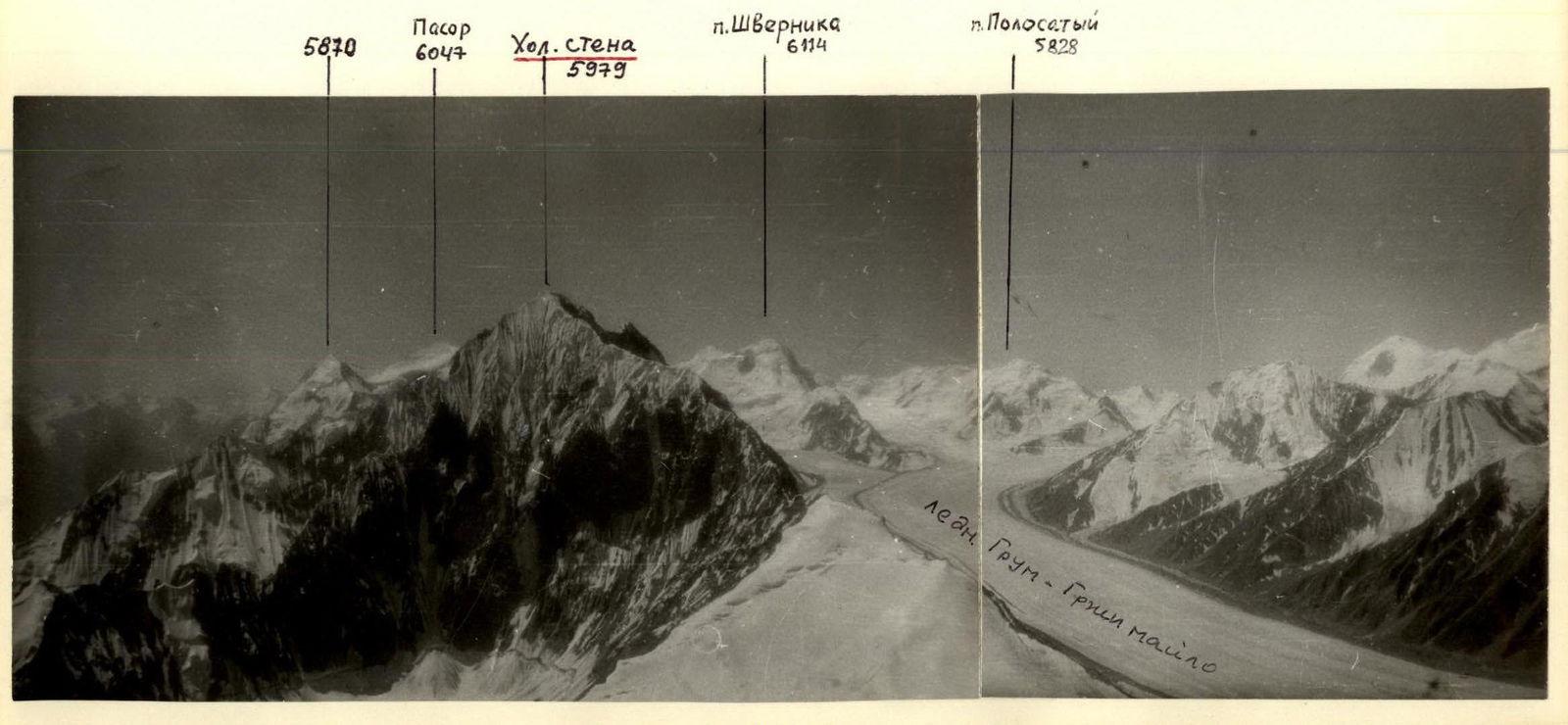
View from the right
Pasor 6047, Khol. стена 5979, p. Shvernika 6114, p. Polosaty 5828. Ledn. Grum–Grip Maсino.
Preparation for the ascent
The team preliminarily familiarized themselves with the object of the ascent through photographs and reports from Kovtun and the Moscow team (1983). The final route was chosen during the Mособлспорткомитет gathering.
There were already three routes on the north face of "Kholodnaya Stena", two of which were 6th category of complexity. Two other beautiful and logical routes were considered, one of which (via the central bastion) was chosen. The route was observed both preliminarily and directly before the ascent. The observation allowed the team to develop a correct tactical plan and choose the necessary equipment.
The team's technical and physical preparation was part of their preparation for the RSFSR championship. Special attention was given to rock climbing training, including a gathering in Crimea.
Available reports on the area were studied. Based on the materials, equipment was prepared, including a suspended platform with a tent.
Safety measures included:
- Using double ropes for all participants. The first climber ascended without a backpack and with a shock absorber. All techniques were practiced both in Crimea and in Khavraz-dara, including catching a falling climber using shock absorbers.
- Optimal and efficient rotation of the lead climber on the route.
- Using specialized tested equipment. In particular, a suspended tent-platform of an original "umbrella" design was used. It was the lightest, most compact, and quickest to set up: 5 kg compared to 12 kg used by the Irkutsk team (Popov's group) and 8+9 kg used by the Leningrad teams (V. Balybarin's and Vasiliev's groups).
- Choosing bivouac sites under overhangs. Avoiding ledges that could be hit by falling rocks.
- A special team of 4–6 people + a doctor with a good assortment of medications and tools was stationed below the route to monitor and assist if needed.
- Contact was established with the Savnob farm management for emergency car and helicopter evacuation.

Ascent schedule
Tactical actions of the team
The first third of the route presented no significant technical difficulties. The main challenge was the high number of loose rocks. On this section, the groups moved in pairs on shortened ropes. From about a third of the way up, the first climber ascended on double ropes, while the others followed on fixed ropes with top-rope belay.
The abundance of loose rocks required careful path selection by the first climber, careful placement of belays, and rope fixing. The lead climber typically worked a full day. For example, on the 13th, Boyko led; on the 14th, Martynov led; on the 15th, Martynov led the rock section, and Boyko led the ice ridge section. The change in lead climber was determined by the complexity of transitioning from rock to ice. Martynov climbed the difficult rock section wearing galoshes, and Boyko was ready for the ice section.
The use of the platform not only provided comfortable bivouacs – there were only places for sitting bivouacs in the second half of the wall – but also influenced the team's tactics. The platform took 20–30 minutes to set up (time to hammer in pitons), allowing the team to work on the route almost all daylight hours. In these conditions, evening route reconnaissance lost much of its value and was not used during this ascent.
There were no falls or injuries during the ascent. Communication with observers was maintained according to the scheduled radio contact using "Vitalna" radios.
Ascent summary
Total: Climbing hours to the summit – 33 Ice screws – 39 Rock pitons – 82 Chocks – 62

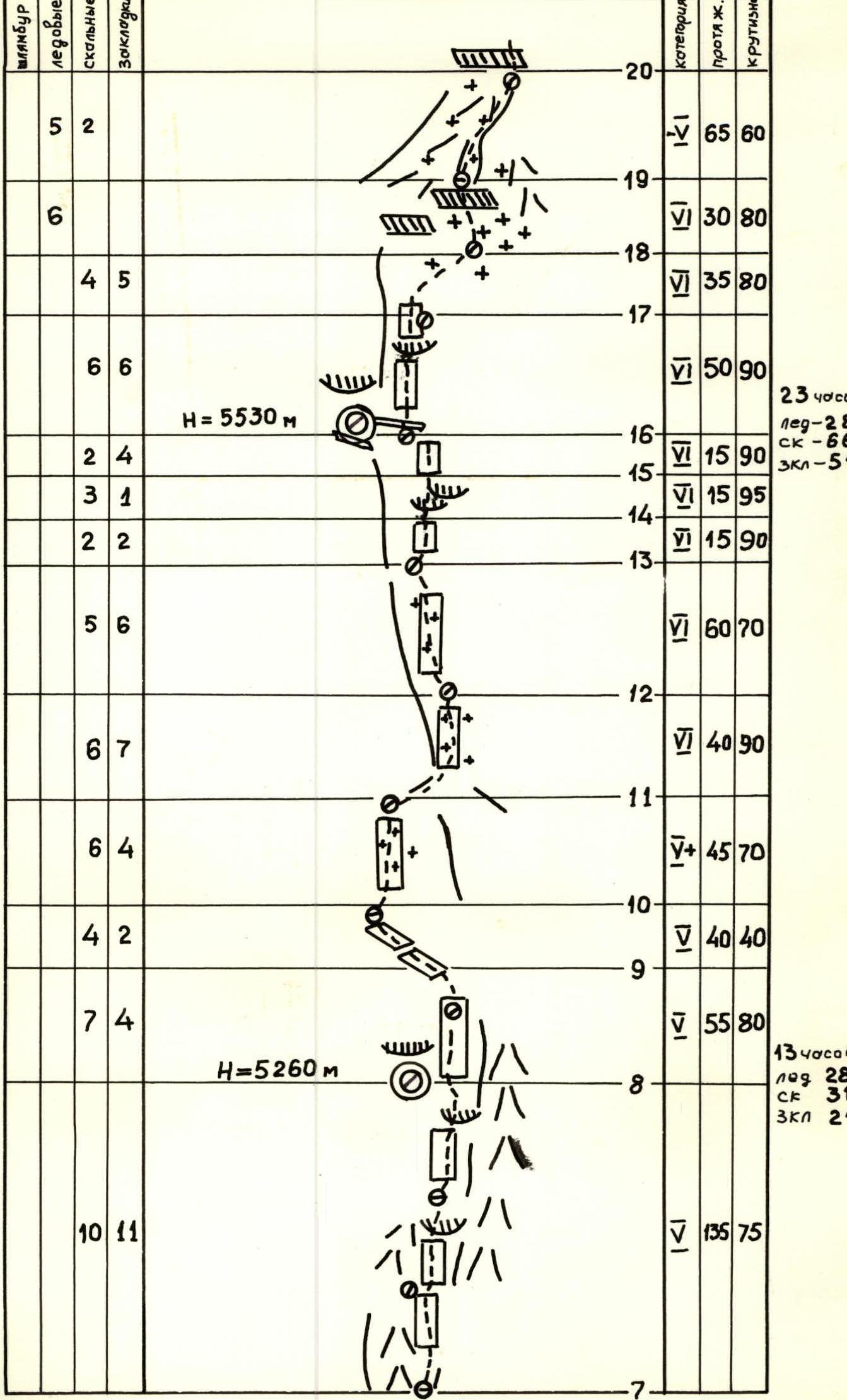
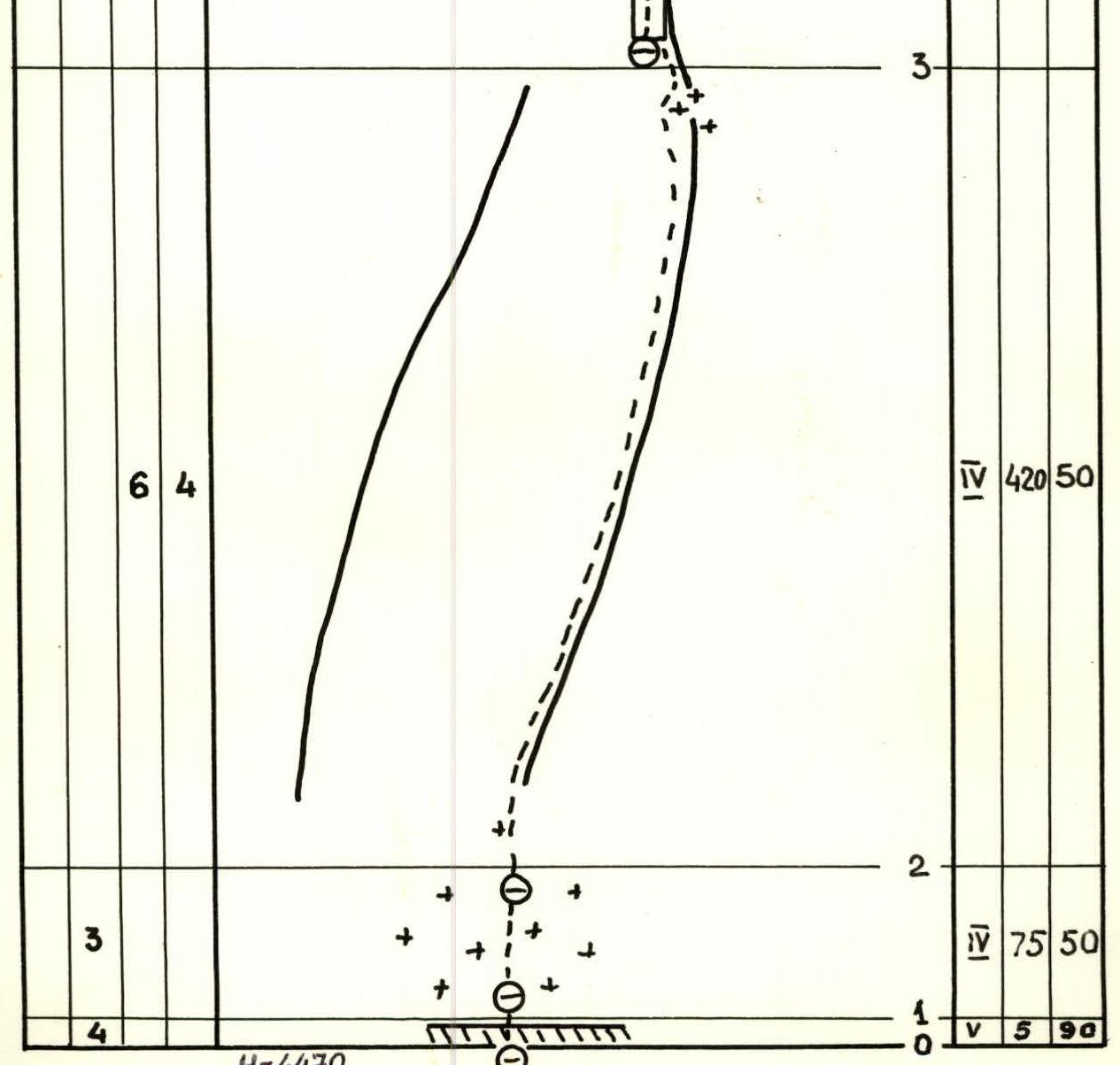
Detailed characteristics of route sections
| Section | Bolt pitons | Ice screws | Rock pitons | Chocks | Category | Length, m | Steepness, ° |
|---|---|---|---|---|---|---|---|
| R0 | 4 | 5 | 5 | 90 | |||
| R1 | 3 | 5 | 75 | 50 | |||
| R2 | |||||||
| R3 | 6 | 4 | 4 | 420 | 50 | ||
| R4 | |||||||
| R5 | 8 | 4 | 5 | 170 | 60 | ||
| R6 | 6 | 3 | 5 | 55 | 65 | ||
| R7 | 5 | 5 | 30 | 90 | |||
| R8 | 10 | 11 | 135 | 75 | |||
| R9 | 7 | 4 | 5 | 55 | 80 | ||
| R10 | 4 | 2 | 40 | 40 | |||
| R11 | 6 | 4 | 5+ | 45 | 70 | ||
| R12 | 6 | 7 | 5 | 40 | 90 | ||
| R13 | 5 | 6 | 5 | 60 | 70 | ||
| R14 | 2 | 2 | 5 | 15 | 90 | ||
| R15 | 3 | 1 | 5 | 15 | 95 | ||
| R16 | 2 | 4 | 5 | 15 | 90 | ||
| R17 | 6 | 6 | 5 | 50 | 90 | ||
| R18 | 4 | 5 | 5 | 35 | 80 | ||
| R19 | 6 | 5 | 30 | 80 | |||
| R20 | 4 | 5 | 2 | 5 | 65 | 60 | |
| R21 | 3 | 5+ | 5 | 90 | |||
| R22 | 3 | 20 | 30 | ||||
| R23 | 5+ | 80 | 60 | ||||
| R24 | 5 | 90 | |||||
| R25 | 500 | 25 |
Route description by sections
- Sections 0–2: Bergschrund and ice slope under an overhanging rock.
- Sections 2–3: A gendarme with a snow cap at the end is bypassed on the left. This section is characterized by a high number of loose rocks.
- Sections 3–4: Broken step-like rocks, partially iced.
- Sections 4–6: A powerful snow overhang ("mushroom"), with dry porous firn on top and ice underneath. Belaying is challenging in the upper part of the "mushroom".
- Sections 6–7: Traverse right along a sheer wall. An alternative is to go straight up the counterfort.
- Sections 7–8: Beginning of the bastion. Sheer rocks with eaves.
- Sections 8–18: These are the key rock sections of the route, characterized by:
- high steepness,
- frequent short overhanging sections. The rocks are more solid than in the lower part of the route and are heavily dissected, providing:
- many holds and places to hammer in pitons,
- many loose rocks; entire blocks can be dislodged from the wall. These sections were climbed by the first climber wearing galoshes. Belay positions on these sections were often inconvenient and could typically accommodate no more than two or three people.
- On sections 10–11, 12–13, 17–18: Thin ice coating.
- Section 18–19: Difficult transition from rock to snow; belaying using ice axes in thickened ice coating. The upper layer of porous firn had to be cleared.
- Sections 19–23: A ridge of closely spaced "mushrooms". Bypassed on the right along steep ice slopes covered with loose snow 0.2–0.7 m deep. The upper part of the "mushrooms" was accessed via steep, loose snow up to chest depth.
- Section 23–24: An overhanging ice cornice with a vertical passage cut through it.
- Section 24–25: The summit ridge with bilateral cornices.
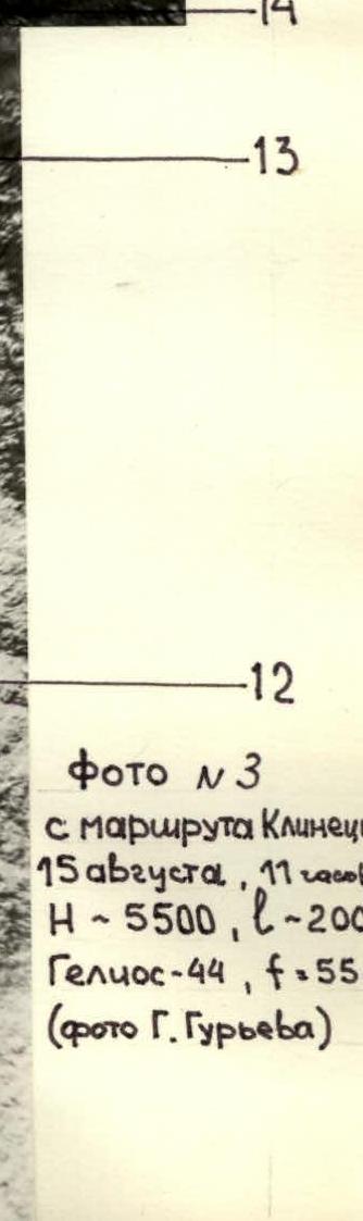
Photo #3 from Klineckii's route
August 15, 11 hours. H-5500, l-200 m. Helios-44, f=55 mm (photo by G. Gurev).


Technical photograph
August 12, 1985, 11 hours. Shot point #1, distance ~2 km. Height ~4400 m. Jupiter-37A, f=135 mm.
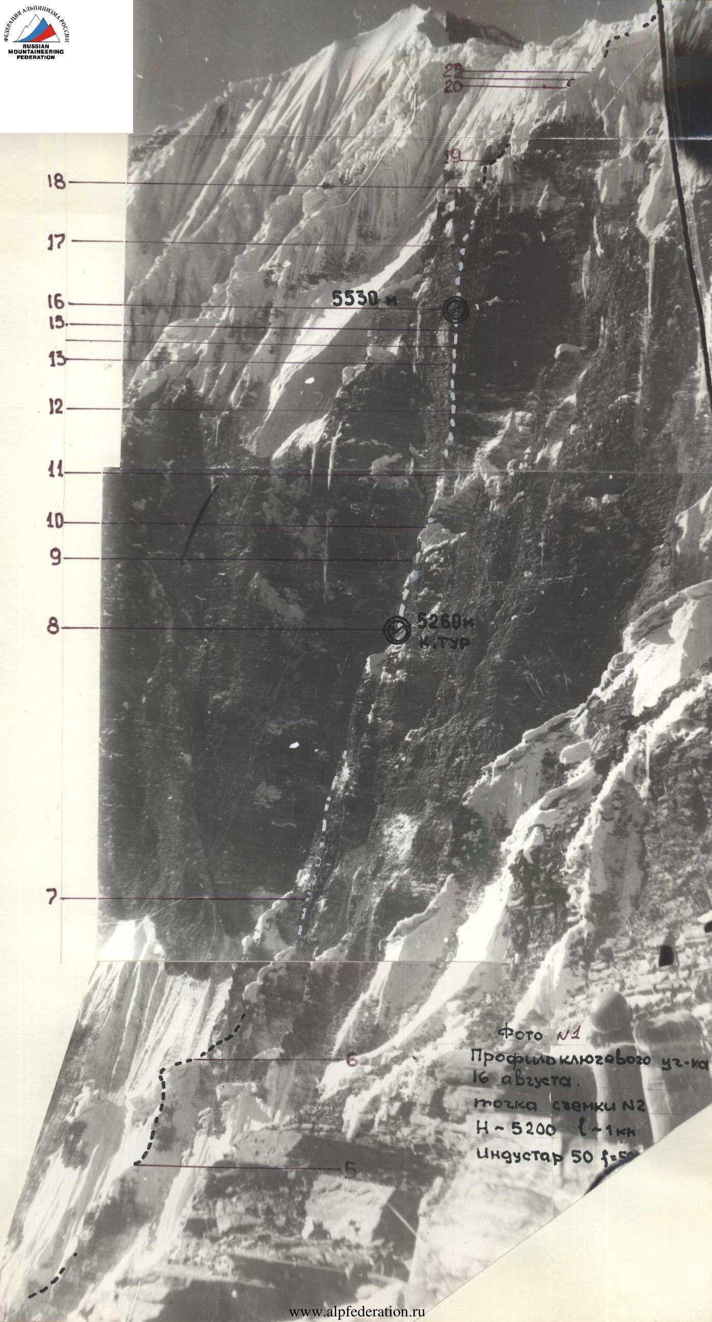
Photo #1 Profile of the key section
August 16. Shot point #2. H ~ 5200 m, l ~ 1 km. Industar-50, f=50.