
REPORT on the first ascent of v. Kholodnaya Stena via the northwestern ridge, category 3B
Group composition:
- Leader:
- Participants: Ponomarchuk V.S., CMS; Matveenko V.M., MS; Ivanov N.R., CMS; Krasnukhin L.I., CMS; Nastobursky A.N., CMS; Kapustina T.D., 1st sports category.
1980

Brief geographical overview
The Kholodnaya Stena peak is located in the northeastern part of the Yazgulemsky ridge in the Central Pamir region, with an elevation of 5959 meters above sea level.
The region is characterized by a dry climate with cold summers and harsh, low-snow winters. The average annual air temperature ranges from -5 to -7 °C. Precipitation is scarce, with 70-120 mm. Vertical gradients reach 1°/100 m.
The region's vegetation is diverse. Walnut trees, maples, Pamir birches, poplars, and willows give way to juniper forests, thorny grasses, and alpine cushions, as well as steppes and meadows, at elevations of 3000-3500 meters. The forest zone is located at 3200-3400 meters above sea level. The wildlife is rich and diverse.
Rivers have a very large drop, originate high in the mountains, and are fed by glaciers and snow.
The approach to the base camp begins from the Kudara settlement, upstream along the Khavraz-Dara river valley. The base camp is located on the left orographic bank of the Khavraz-Dara river, 0.5 km above Lake Khavraz-Dara.
Map of the ascent area
M 1:100 000
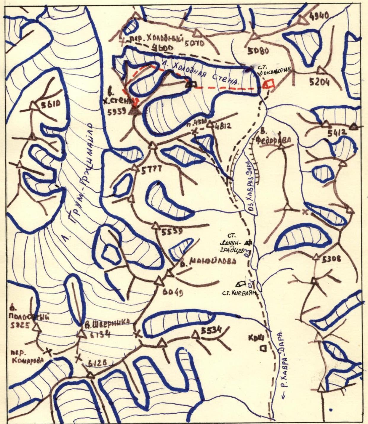
- Assault group route
- Expedition base camp
- Assault camp
Brief description of the approach to the route
From the base camp, located 1 km from the Kholodnaya Stena glacier, along the left orographic side to the terminal moraine of the glacier - 30 min. Then, ascent along the left part of the terminal moraine, exiting onto the left lateral moraine, following the direction of travel until the confluence of the Kholodnaya Stena glacier and the glacier flowing from under the southeastern wall of v. Kholodnaya Stena - 1 h 10 min.
Then, in the direction of the northeastern ridge of v. Kholodnaya Stena - 1 h.
Further movement proceeds in the direction of the scree-covered northwestern ridge, closing the cirque of the northern wall, to the start of the route - 20 min.
The route begins along a gentle scree slope leading to the ridge.
The total approach time to the route is 3 h.
Table of main characteristics of the route by sections
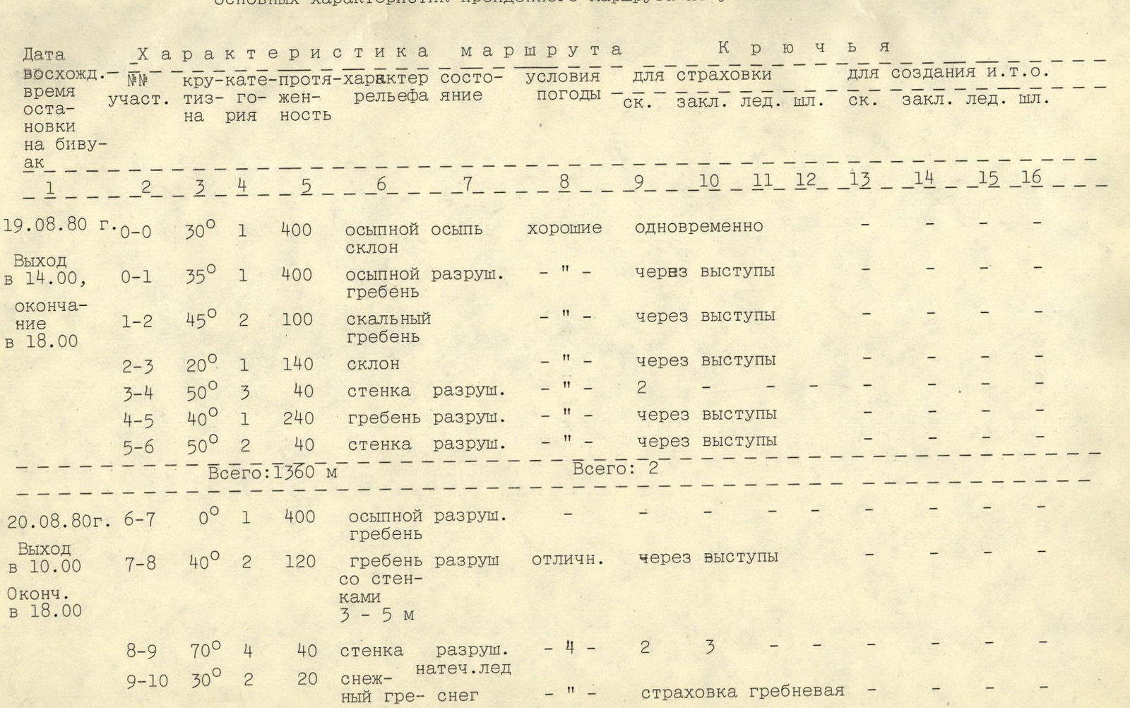
Route characteristics by sections:
August 19, 1980:
- Departure at 14:00, completion at 18:00.
- Section R0: steepness 30°, category 1, length 400 m. Terrain character: scree slope. Condition: scree. Weather conditions: good. Belay: simultaneous.
- Section R0–R1: steepness 35°, category 1, length 400 m. Terrain character: scree-covered, destroyed ridge. Condition: -. Weather conditions: good. Belay: through outcrops.
- Section R1–R2: steepness 45°, category 2, length 100 m. Terrain character: rocky ridge. Condition: -. Weather conditions: good. Belay: through outcrops.
- Section R2–R3: steepness 20°, category 1, length 140 m. Terrain character: slope. Condition: -. Weather conditions: good. Belay: through outcrops.
- Section R3–R4: steepness 50°, category 3, length 40 m. Terrain character: wall, destroyed. Condition: -. Weather conditions: good. Belay: 2.
- Section R4–R5: steepness 40°, category 1, length 240 m. Terrain character: ridge, destroyed. Condition: -. Weather conditions: good. Belay: through outcrops.
- Section R5–R6: steepness 50°, category 2, length 40 m. Terrain character: wall, destroyed. Condition: -. Weather conditions: good. Belay: through outcrops.
- Total for the day: 1360 m. For belaying: 2 rock pitons were placed.
August 20, 1980:
- Departure at 10:00, completion at 18:00.
- Section R6–R7: steepness 0°, category 1, length 400 m. Terrain character: scree-covered, destroyed ridge. Condition: scree. Weather conditions: -. Belay: -.
- Section R7–R8: steepness 40°, category 2, length 120 m. Terrain character: ridge, destroyed, with 3-5 m walls. Condition: excellent. Weather conditions: -. Belay: through outcrops.
- Section R8–R9: steepness 70°, category 4, length 40 m. Terrain character: wall, destroyed (flow ice). Condition: flow ice. Weather conditions: -. Belay: 4 rock pitons, 2 chocks, 3 ice screws.
- Section R9–R10: steepness 30°, category 2, length 20 m. Terrain character: snowy ridge. Condition: snow. Weather conditions: -. Belay: ridge.
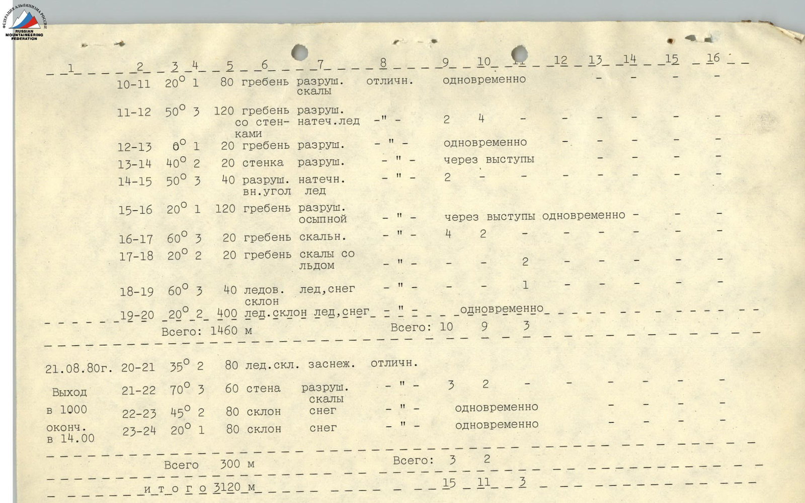
- Section R10–R11: steepness 20°, category 1, length 80 m. Terrain character: ridge, destroyed (rocks). Condition: excellent. Weather conditions: -. Belay: simultaneous.
- Section R11–R12: steepness 50°, category 3, length 120 m. Terrain character: ridge, destroyed, with walls (flow ice) (rocks). Condition: flow ice. Weather conditions: -. Belay: 2 rock pitons, 4 chocks.
- Section R12–R13: steepness 6°, category 1, length 20 m. Terrain character: ridge, destroyed. Condition: -. Weather conditions: -. Belay: simultaneous.
- Section R13–R14: steepness 40°, category 2, length 20 m. Terrain character: wall, destroyed. Condition: -. Weather conditions: -. Belay: through outcrops.
- Section R14–R15: steepness 50°, category 3, length 40 m. Terrain character: destroyed inner corner (flow ice). Condition: flow ice. Weather conditions: -. Belay: 2 rock pitons.
- Section R15–R16: steepness 20°, category 1, length 120 m. Terrain character: ridge, destroyed, scree-covered. Condition: scree. Weather conditions: -. Belay: through outcrops, simultaneous.
- Section R16–R17: steepness 60°, category 3, length 20 m. Terrain character: rocky ridge. Condition: -. Weather conditions: -. Belay: 4 rock pitons, 2 chocks.
- Section R17–R18: steepness 20°, category 2, length 20 m. Terrain character: rocky ridge with ice. Condition: -. Weather conditions: -. Belay: 2 rock pitons.
- Section R18–R19: steepness 60°, category 3, length 40 m. Terrain character: ice slope. Condition: ice, snow. Weather conditions: -. Belay: 1 ice screw.
- Section R19–R20: steepness 20°, category 2, length 400 m. Terrain character: ice slope. Condition: ice, snow. Weather conditions: -. Belay: simultaneous.
- Total for the day: 1460 m. For belaying: 10 rock pitons, 9 chocks, 3 ice screws were placed.
August 21, 1980:
- Departure at 10:00, completion at 14:00.
- Section R20–R21: steepness 35°, category 2, length 80 m. Terrain character: snow-covered ice slope. Condition: excellent. Weather conditions: -. Belay: -.
- Section R21–R22: steepness 70°, category 3, length 60 m. Terrain character: wall, destroyed (rocks). Condition: rocks. Weather conditions: -. Belay: 3 rock pitons, 2 chocks.
- Section R22–R23: steepness 45°, category 2, length 80 m. Terrain character: slope. Condition: snow. Weather conditions: -. Belay: simultaneous.
- Section R23–R24: steepness 20°, category 1, length 80 m. Terrain character: slope. Condition: snow. Weather conditions: -. Belay: simultaneous.
- Total for the day: 300 m. For belaying: 3 rock pitons, 2 chocks were placed.
Total: 3120 m. For belaying: 15 rock pitons, 11 chocks, 3 ice screws were placed.
Brief description of the route
The route can be conditionally divided into 3 parts:
- Ascent to the 5200 m shoulder along a gentle scree slope.
- A 400-meter ascent with an average steepness of 50° to the snow-ice shoulder of the ridge at an elevation of 5600 m - the technically challenging part of the route.
- Snow-ice ascent to the summit.
The group approached the route on August 19, 1980, at 14:00. The beginning of the route is a not clearly defined scree couloir. Further movement to the 5200 m shoulder was carried out along a scree ridge with rare, destroyed walls of average steepness 45° (sections R0–R6).
The group reached the shoulder at 18:00 and set up an overnight camp.
On August 20, 1980, at 10:00, the group continued on the route, moving along a horizontal scree ridge R6–R7, then along destroyed rocks with a steepness of 40° R7–R8, to a 40-meter wall of "flow ice" - piton belay. Along the wall R8–R9, they exited onto a snowy shoulder R9–R10. Then, along a destroyed ridge for 240 m R10–R14, and a destroyed inner corner with flow ice R14–R15 - piton belay. Further along the ridge (destroyed rocks) R15–R18, to a snow-ice slope, and along it R18–R20, they reached the 5600 m shoulder. Here, at 18:00, the group set up another overnight camp.
On August 21, 1980, at 10:00, the group continued on the route. Along a snow-ice slope R20–R21, to a 60-meter wall, destroyed rocks R21–R22 - piton belay.
Then, along a snowy slope R22–R24, to the summit. The group reached the summit at 14:00.
The descent was made via the ascent route.
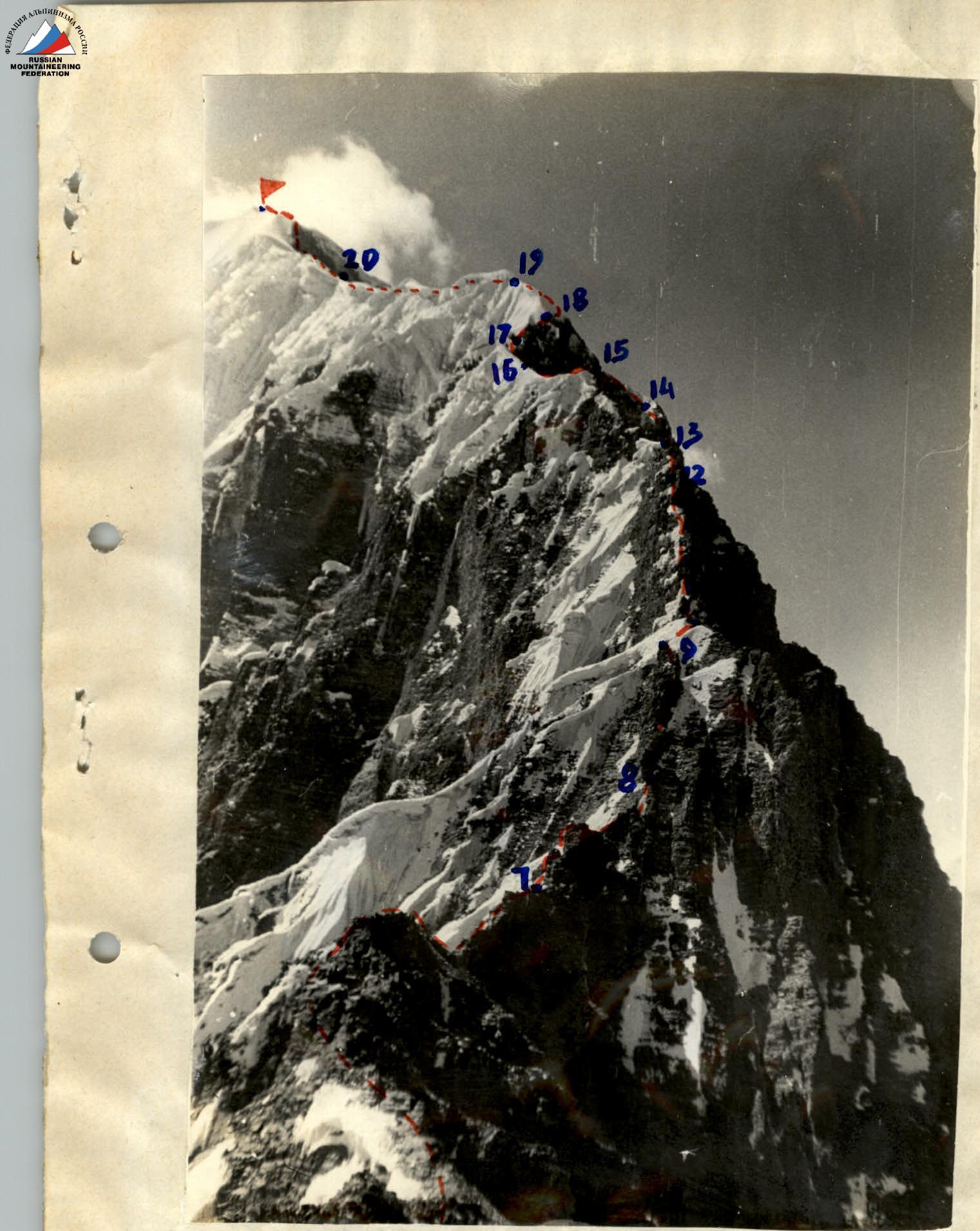 v. Kholodnaya STENA (NW ridge) Sections R7–R20

Comments
Sign in to leave a comment