

REPORT
ON THE ASCENT OF PIK FIKKER (6718 m)
BY THE SPORTS CLUB AN SSSR TEAM
Pamir, July–August 1960

Map of the expedition area: 1 — Base camp, 2 — First cave, 3 — Second cave.
Area of Operation
Pik Fikker (see Figs. 1, 3) with a height of 6718 m is located approximately in the middle of the mountains of the southern Fedchenko group, bordering the right (orographic) bank of the upper reaches of the Fedchenko glacier (see photo scheme). To the north and south from Pik Fikker, the main ridges extend to other peaks of the southern Fedchenko group. The eastern slopes of Pik Fikker descend directly onto the Vitskovsky glacier, which flows into the Fedchenko glacier significantly to the north, and the western slopes feed a small (unnamed) glacier, also a tributary of the Fedchenko glacier. Below, we will refer to it as the Fikker glacier.
Characteristic features of the ascent area (see, for example, Fig. 1) include:
- smooth flow of the main glaciers;
- abundance of hanging glaciers.
Therefore, reaching the pre-summit ridges presents certain tactical difficulties. The peaks are snow-rock in nature.
The year 1960 was a low-snow year. Throughout the team's stay in the Pik Fikker area, they did not encounter any glacier sections covered with snow more than 20–30 cm. However, due to the smooth flow of the glaciers, this circumstance did not hinder movement across them. On the approaches, the team did not encounter crevasses wider than 1 m.
Camps on the Fedchenko and Fikker glaciers can be set up almost anywhere, but water is scarce. On the Fedchenko glacier (from the Abdugor II pass to the Fikker gorge), there is none. On the Fikker glacier, water was found in only two places in depressions formed near rock outcrops (see Fig. 1).
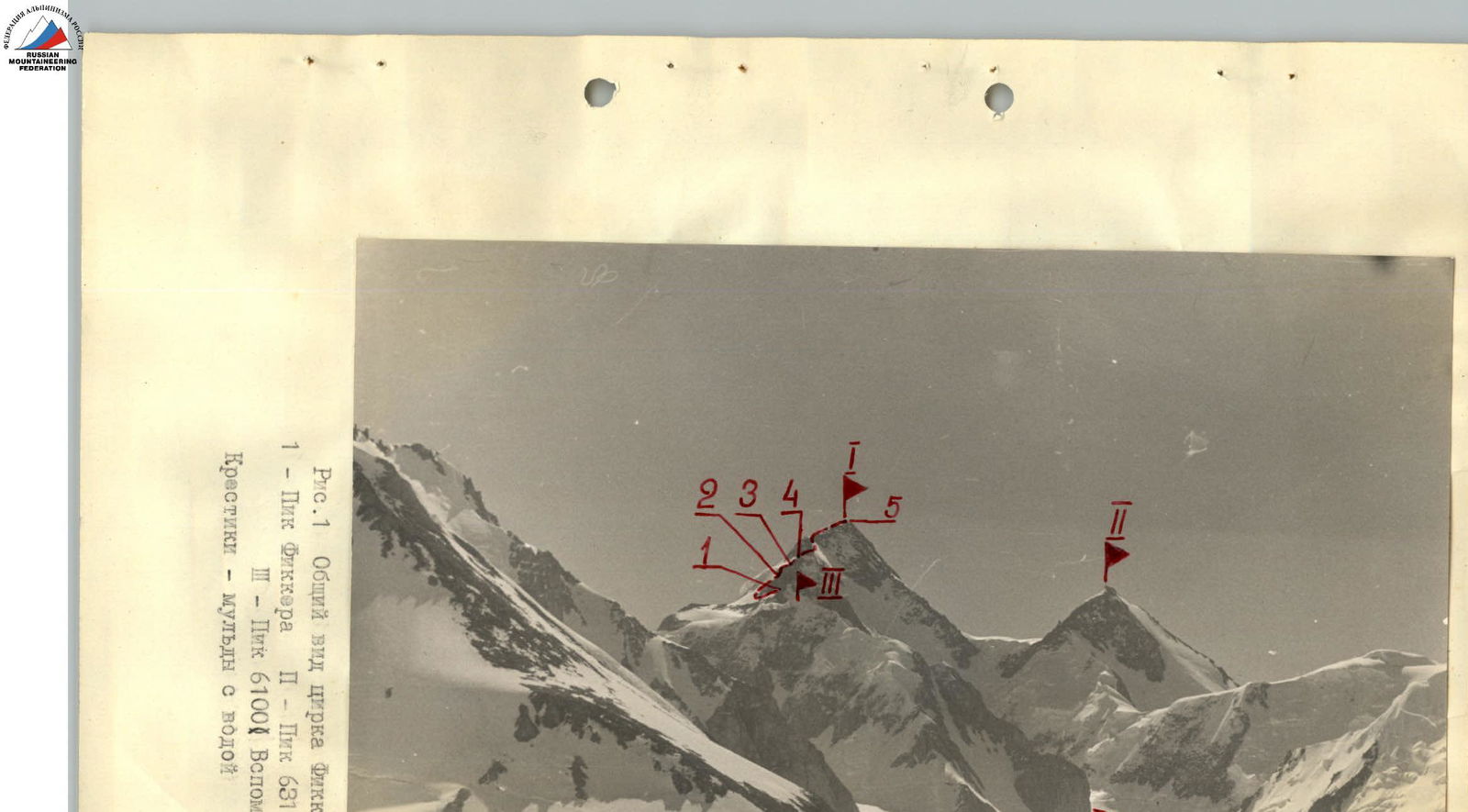
Fig. 1. General view of the Fikker cirque
- Pik Fikker
- Pik 6315 (Omar Khayyam)
- Pik 6100 (Vspomogatelný)
Crosses — depressions with water
Preparatory Stage
The upper reaches of the Fedchenko glacier area is one of the most inaccessible in the Pamir. It is located approximately 100 km from the Pamir highway (Garm, Tajik SSR) and 40 km from the end of the road (geologists' settlement Dalniy). About a third of the distance from Dalniy upstream can be traversed with a caravan.
This circumstance makes the Fedchenko glacier area relatively frequently visited (expedition led by S.M. Lukomsky, 1955; SКАN expeditions, 1957 and 1960). From July 15 to August 20 of the current year, for example, it was visited (apart from the SK AN expedition) by 5 tourist groups from Moscow, Leningrad, Riga, and Kharkov with participant numbers ranging from 8 to 25.
The team that ascended Pik Fikker this year was part of the expedition organized by the Sports Club of the USSR Academy of Sciences (SK AN), set up by the Central Council and the Moscow Regional Council of the "Burevestnik" Sports Society. The ascents conducted by SK AN in the same area in 1957 required significant effort and endurance from the participants. According to the 1957 expedition members, this was due to both harsh snowy conditions and bad weather, as well as insufficient altitude acclimatization.
Therefore, the main task of the preparatory period for the team was not only to carry out supplies and materially support the ascent but also to gain active acclimatization.
Below is a detailed description of the expedition's work schedule and the assault team's plan.
The SK AN SSSR expedition 1960 departed from Moscow on July 2, arrived in Stalinabad on July 7, in Garm on July 9, in Dalniy on July 11, and in the Base camp on July 14, located at an altitude of 4000 m on the shore of a glacial lake formed between two lateral moraines on the left bank of the Abdugor glacier (see Fig. 2).
The number of expedition participants was 25. The cargo weighed 4.5 tons. The cargo was transported to the Base camp in stages:
- by train;
- by car;
- by caravan.
The most natural path to Pik Fikker from the Base camp passes through the Abdugor II pass (5100 m). The main difficulty lies in the ascent to the pass. The path then proceeds across even snowfields. Accordingly, it was decided to supply products and equipment for the ascent to Pik Fikker in two stages: first, to carry everything necessary to the Abdugor II pass, and then, after reconnaissance, to transport this cargo by sled directly to the Fikker glacier, from where the assault would begin. In the first stage of the expedition's work, training ascents by participants to peaks of 5700–6000 m were also planned.
To achieve more even acclimatization, it was decided to establish an intermediate camp at an altitude of 4500 m, halfway between the Base camp and the Abdugor II pass.
The first sortie with supplies was made on July 14 by a group of 12. The weight of the backpacks was 10–20 kg. The cargo was delivered to the 4500 camp, after which the group descended to the Base camp. The next day, the supply run to the 4500 camp was repeated with the full complement of climbers.
- The first group stayed overnight at 4500 and on July 16 ascended to the pass, where they spent the night.
- The second group descended, on July 17 went to the 4500 camp, and on July 18 to the pass, where the first group had largely dug a cave (see Fig. 3) in the steep slope of a cirque.
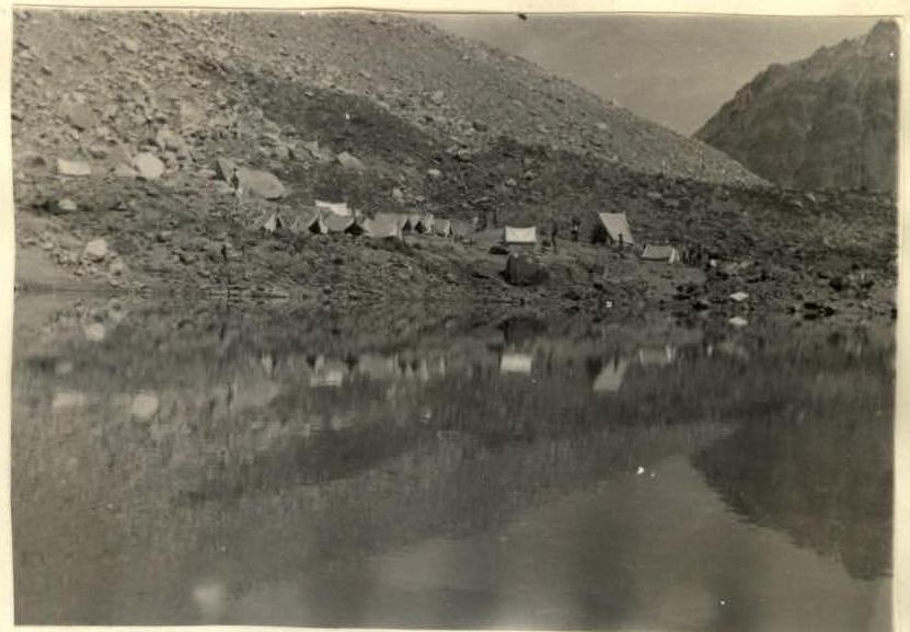
Fig. 2. Base camp
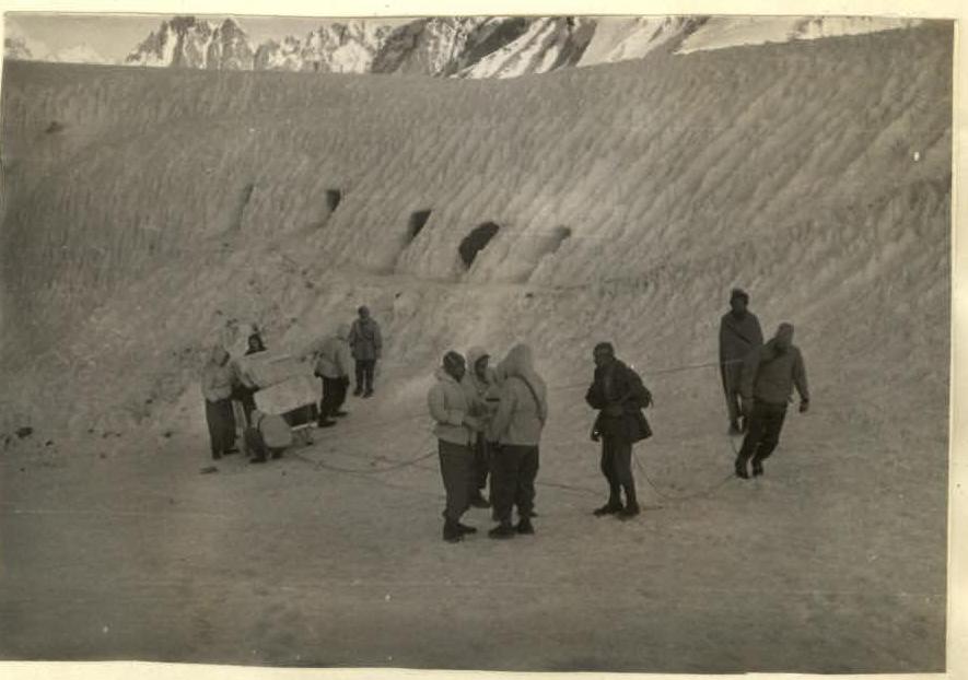
Fig. 3. First cave (Abdugor II pass)
On July 18, the second group continued organizing the second base camp. Part of the first group descended to the 4500 camp, while another part conducted reconnaissance of the training ascent routes (see Fig. 4).
On July 19, the group that had spent the night at 4500 m conducted another supply run to the pass, after which they returned to the Base camp.
On July 20, the second group, having also made one supply run from 4500 m to the pass, descended to the Base camp.
Ascent times were:
- from the Base camp to 4500 m — 2.5–3.5 hours;
- from 4500 m to the pass — 3.5–5 hours.
Thus, the organization of the 2nd (cave) Base camp, supply runs, and reconnaissance of training routes were completed by July 20. By this time, each participant had ascended to the 4500 camp several times and at least twice to the Abdugor pass (5100 m), spending at least one night at each altitude.
500 kg of cargo was delivered to the pass. 400 kg of cargo remained in the first camp (4500 m). Backpacks did not exceed 15–25 kg.
The acclimatization and training gained by participants during these sorties allowed them, when they ascended on July 23 for training ascents, to climb peaks of 5700–6000 m without any signs of altitude sickness. The two days (July 21 and 22) they spent in the camp were also sufficient for full rest.
Between July 23 and 27, all expedition participants conducted 1–2 training ascents. There was one rest day between ascents. During this time, 5 expedition members (Smit, Miklevich, Dubinin, Bongard, Filimonov) under the leadership of the expedition leader Smit V.A. conducted the first supply run with sleds (see Fig. 5) to the Fikker gorge, carried out reconnaissance of the ascent to Pik Fikker, and selected objects in the Fikker gorge for ascents by the remaining expedition participants.
At this point, the preparatory stage was concluded. Acclimatization and training allowed virtually all expedition participants to undertake subsequent ascents above 6000 m without any signs of altitude sickness. It is worth noting that during the first ascent to the Abdugor pass (5100 m), most participants experienced quite intense symptoms of altitude sickness:
- headache;
- nausea;
- loss of appetite.
The weather during the preparatory period was poor: it snowed daily (up to 4000 m), sometimes rained, and clouds descended to 4800 m, although the first half of the day was sometimes good. Subsequently, the weather stabilized, and there was not a single bad day in August.
Ascent Plan
Even before departing from Moscow, it was known from literary sources that in 1928, members of a mixed Soviet-German expedition, Schneider and Wien, had ascended Pik Fikker. However, the route description is absent from both the Russian and German reports of the 1928 expedition. It is only known that the ascent was made from the Vitskovsky glacier.
It was also known that in 1959, a group of meteorologists-winterers led by Nozdyrukhin ascended Pik Fikker from the Vitskovsky glacier (their note was retrieved from the summit of Pik Fikker by our team). This group also did not have a route description, as they had planned to ascend Pik Fikker from the opposite side — via the western slope of the peak.
The ascent made this year by seven members of the SK AN SSSR expedition, who ascended Pik Fikker via the western ridge, can be considered a first ascent, as apart from everything else, Nozdyrukhin's group did not register their ascent with any sports organizations.
The reconnaissance conducted allowed us to establish the following. The summit ridge of Pik Fikker (see section 1–5 on Fig. 8) consists of two parts, of which the upper (see section 4–5 on Fig. 8) is more gradual and does not present technical difficulties at first glance. The lower part of the ridge (sections 1–4 on Fig. 9) is steeper on average and contains a number of steep rock drops. The terrain at the end of section 3–4 contains many heavily fragmented rocks and is clearly visible from a distance. Below, for brevity, it will be referred to as the "curly gendarme". Overcoming the ridge is possible head-on or along its northern slope if there are bypass paths. The exit to the summit ridge is possible only along the southern slope of a small counterfort extending westward from the main ridge, connecting Pik Fikker (6718 m) with peak 6419. In all other technically accessible locations, movement must occur either under hanging glaciers or along very dangerous bilateral cornices.
In accordance with this, the following tactical ascent plan was devised.
The assault team, along with the support team, will exit early in the morning from the 2nd cave camp, located in the middle of the Fikker glacier (see Fig. 1), and ascend to the saddle between the summit ridge and the counterfort extending from it (section R0–R1).
Here, they will spend the night. From this location, the support team, having ascended to the highest point of the western counterfort (6100 m), will descend back to the 2nd cave camp. Three observers will be designated from their composition.
The remaining climbers, simultaneously with the continuing ascent to Pik Fikker, will ascend peaks within direct visibility of Pik Fikker (apart from 6100, marked as 6419 and 6050).
Over the next two days, the group will traverse the ridge section R1–R4, on the fourth day, they will ascend from the "curly gendarme" (mark 4) to the summit and descend to spend the night under the "curly gendarme". On the fifth day, they will descend to the 2nd cave camp.
The entire ascent was planned for 5 days + 3 reserve days. The planned ascent plan for the second sortie allowed for mutual observation of all groups and quick assistance in case of an accident. Additionally, all groups (including observers) were equipped with VHF radios and flares of two colors.
The planned plan was fully executed within the scheduled timeframe.
The assault team consisted of the following climbers: Smit V.A. (leader), Miklevich A.V., Bongard M.M., Dubinin V.A., Voronov B.S., Smirnov Yu.I., Filimonov G.F. This composition differed from the one planned in Moscow because three of the originally nominated team members: Tamm, Bazhukov, and Babayan — were unable to participate in the climb.
The support team consisted of 10 people. It was led by Kalachev L.D. Kuznetsova G.D. was appointed as the leader of the observation group.
Assault
On July 31, the first group, consisting of 12 people led by Shchetlín V.M., departed from the Base camp and, having collected cargo from the 4500 camp and the 1st cave camp (400–450 kg), delivered it by the evening of August 1 to the middle of the Fikker glacier. Here, the 2nd cave camp was established. On August 2, the second group of the expedition arrived with 200 kg of cargo. A total of 600 kg of cargo, consisting of necessary equipment, a rescue fund, and provisions for all participants for 10 days, was delivered to the 2nd cave camp by sled.
On August 3 at 5:00, the assault team, along with the support team, set out to ascend Pik Fikker. The remaining groups acted according to the plan.
The path to the initial ascent point on the western ridge took 1.5 hours. The general view of the path — the exit to the western ridge and Pik Fikker from the upper cirque of the Fikker glacier — is given in Fig. 7b. It is a snow-ice slope with uneven steepness and a thin layer of snow on the ice. The entire path was traversed in crampons.
Crossing the bergschrund is not complicated. Further, there is an ice slope with a steepness of 40° and a snow layer of about 10–20 cm. The path along it leads to the first rock outcrop and then to the first rock island.
Here, simultaneous movement with insurance through rock outcrops is possible. Further along the ridge with a fairly deep snow layer, insurance through an ice axe is possible. The group ascended to the middle of the ice couloir separating the first rock island from the second and began to traverse rightward to the second rock island.
Here, there is no snow, the steepness is 50–55°. Hook protection is necessary. The ice is quite porous, and crampons hold well.
Above the 2nd rock island, the path is convenient along the top of the snow ridge with a steepness of 35–40°. Here, the snow is deep, but in the lower part of the ridge, it is loose, and in the upper part, it is powdery. Therefore, hook insurance is also needed here. The exit to the saddle (point 1) is not complicated. The height of the saddle is 6000 m. The height gain of section R0–R1 is 800–900 m. During its passage, 6 ice and 2 rock hooks were driven. The group reached the saddle along with the support team at 17:00 and set up a bivouac. The location is convenient and can accommodate many tents. There is no water, as is the case throughout the route.
On August 4, the support team, having ascended to the summit of peak 6100 and naming it Pik Vspomogatelný, descended to the 2nd cave camp. The support team delivered about 40 kg of food and equipment to the first bivouac for the assault team, mainly as a reserve in case of unforeseen circumstances. The assault team departed from the bivouac at 11:00. The path proceeded across extensive snowfields on the northern slope of the western ridge, which became steeper as they ascended and gradually turned into ice drops. Upon reaching the second bivouac, the snow steepness reached 45–50°. It was dense firn, and a foothold could only be achieved with 4–5 kicks of the foot. Traversing section R1–R2 took the group 3 hours. However, due to the fact that the group slept poorly the previous night (due to tightness in the tents), it was decided to set up a second bivouac here and not to traverse the technically difficult section R2–R3 that day. The location for the bivouac was convenient and safe.
On August 5, the group overcame section R2–R4 in 5 hours and reached the base of the "curly gendarme". The path section R2–R3 consists of steep (up to 60°) rock-fragmented slopes. They have sufficient protrusions and handholds for hands and feet. However, there are few convenient insurance points, and the slopes are heavily snowed. Therefore, hook protection is necessary. 7 rock hooks were driven. Figs. 3 and 10 depict individual sections of this route.
Bypassing this rock outcrop via snow is theoretically possible, but the snow is very steep and, in this (low-snow) year, consisted of a dense firn substrate, into which it is impossible to drive an ice axe, and loose snow 20–30 cm thick, not everywhere firmly lying on the firn substrate. Therefore, this route variant was not feasible this year.
Having passed the lower snow ridge of section R3–R4, the group approached the 2nd rock outcrop. It is bypassed on the left (in the direction of travel) via a steep (about 40°) snow-ice couloir (see Fig. 11). The path (1.5 ropes) is very unpleasant: loose snow (about 20 cm) lies unstably on dense ice. Here, 2 rock hooks were driven.
The further path to the "curly gendarme" proceeds along snow ridges at the edge of rocks and snow. It does not present technical difficulties. The participants' well-being on this and the following day was excellent.
Fig. 12 depicts the bivouac under the "curly gendarme". It is convenient and safe. Its height is about 6400 m.
On August 6, the group departed at 9:00 without backpacks to storm the summit. According to reconnaissance, section 4–5 is not steep and is not complicated. The height difference is about 300 m. The weather is excellent. The group believed it could traverse section 4–5 from bivouac to bivouac within a day without backpacks. And indeed:
- The path to the summit took 3 hours;
- The descent took 2 hours.
By 14:00, the group was already at the bivouac.
The reconnaissance data were correct. Section 4–5 is a snow-rock ridge with cornices and steep rock and snow ascents (Fig. 13 shows a view of this ridge above the "curly gendarme"). Its technical complexity can be assessed as category II. Everywhere, simultaneous movement with insurance through rock outcrops and ridge bends is possible. The "curly gendarme" is bypassed on the right in the direction of travel.
The summit of Pik Fikker (see Figs. 14, 15) is a monolithic rock on which not even one person can stand. A cairn is built under it. Nozdyrukhin's note was retrieved from it.
The descent proceeded along the ascent path. By 14:00, the group was already at the overnight stay location. Having dismantled the bivouac, the group moved down along the ascent path and by 21:00 reached the 2nd base camp.
The ascent took 4 days instead of the 5 planned. Under favorable conditions, section R1–R4 can apparently be traversed in one day.
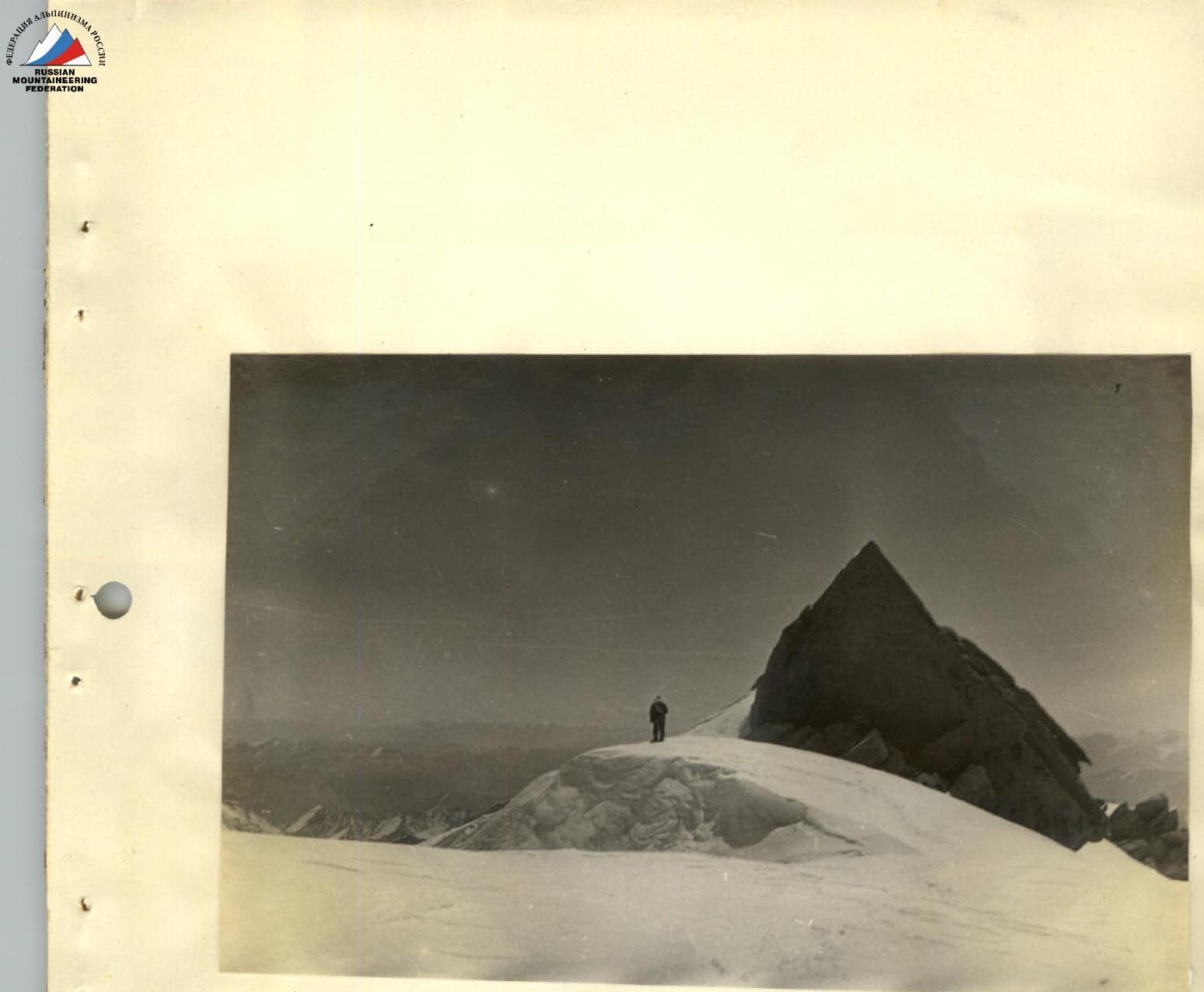
Fig. 14. Summit of Pik Fikker.
Overall Assessment of the Route and Team Performance
The route is combined, featuring steep snow-ice slopes and ridges, as well as rock sections. However, the main technical difficulties are encountered on snow and ice (section R0–R1). Particular caution was required when traversing steep ice slopes with a thin layer of snow on them. Since there was little snow in the 1960 season, there was no danger of avalanches.
If evaluating the route solely by its technical complexity, it is:
- more challenging than Dikh-Tau via the 4B route;
- more challenging than Ushba (northern peak);
- more challenging than Koshtan-Tau (4B);
- and little different from the route to Pik 26 Commissars (5B).
For a correct assessment of the route in its entirety, one must also consider the obvious difficulties posed by the altitude. Overall, the team believes that this route can be classified as a category 5B route.
The route was traversed normally, in full accordance with the planned plan. No extraordinary incidents occurred. All participants were in good form and progressed evenly. Regular radio communication was maintained with other groups from the sports club and with the observation group, which also conducted visual monitoring of the ridge of Pik Fikker.
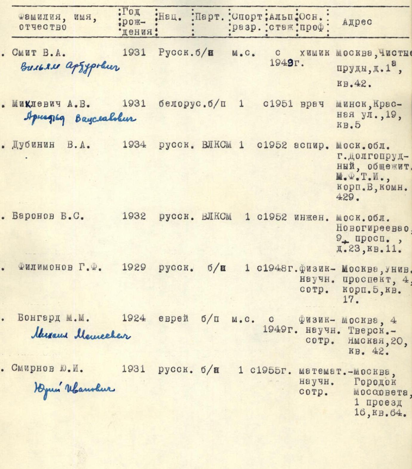
Information about Participants
| Surname, First Name, Patronymic | Year of Birth | Nationality | Party Affiliation | Sports Rank | Climbing Experience | Main Profession | Address |
|---|---|---|---|---|---|---|---|
| 1. Smit V.A. Vil'iam Arburovich | 1931 | Russian | Non-party | Master of Sports | Since 1949 | Chemist | Moscow, Chistye Prudy, d. 1, kv. 42. |
| 2. Miklevich A.V. Arnol'd Vyacheslavovich | 1931 | Belarusian | Non-party | 1st Category | Since 1951 | Doctor | Minsk, Krasnaya ul., 19, kv. 5. |
| 3. Dubinin V.A. | 1934 | Russian | Komsomol member | 1st Category | Since 1952 | Postgraduate student | Moscow Region, Dolgoprudny, MFTI dormitory, corp. V, room 429. |
| 4. Voronov B.S. | 1932 | Russian | Komsomol member | 1st Category | Since 1952 | Engineer | Moscow Region, Novogireevo, 9-y prosp., d. 23, kv. 11. |
| 5. Filimonov G.F. | 1929 | Russian | Non-Komsomol | 1st Category | Since 1948 | Physicist, Research Scientist | Moscow, Universitetsky prospect, 4, corp. 5, kv. 17. |
| 6. Bongard M.M. Mikhail Moiseevich | 1924 | Jewish | Non-party | Master of Sports | Since 1949 | Physicist, Research Scientist | Moscow, 4-ya Tverskaya-Yamskaya, 20, kv. 42. |
| 7. Smirnov Yu.I. Yuri Ivanovich | 1931 | Russian | Non-Komsomol | 1st Category | Since 1955 | Mathematician, Research Scientist | Moscow, Gorodok Mosсовета, 1-y proezd, 16, kv. 64. |
Comments
Sign in to leave a comment