
4.12.44.54
Description of the First Ascent of Peak 6150 m
Coleencreux Kosmonavtov.
I. Geographical Information
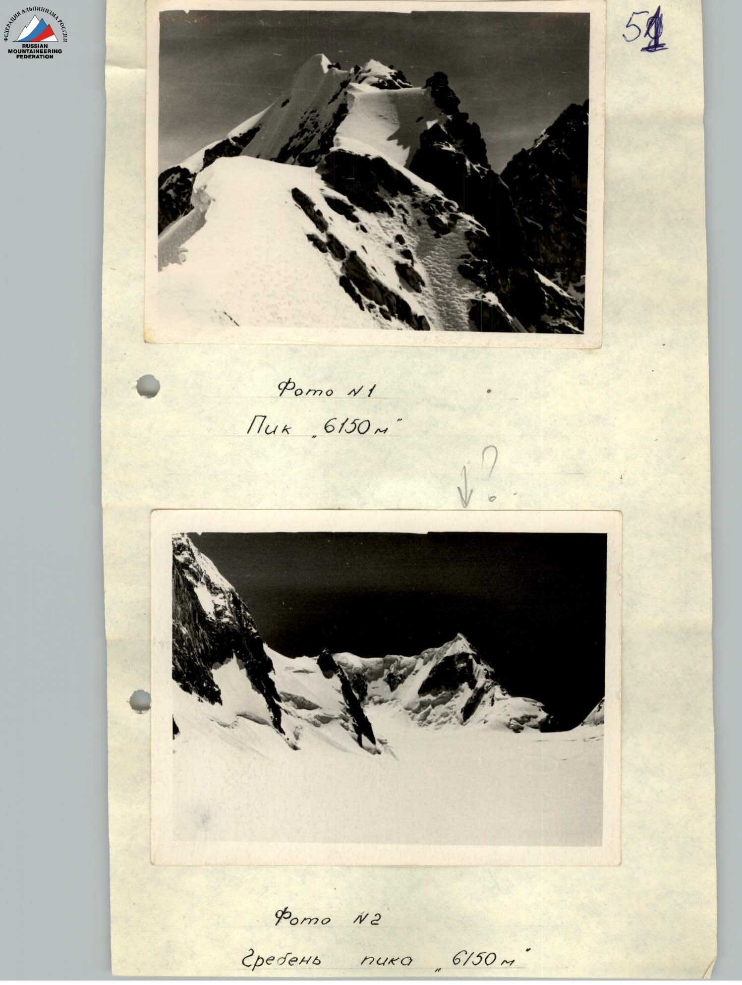
Peak 6150 m (photo 1 and 2) is located in the southeastern part of the Fedchenko Glacier, in the Pik Ficker ridge, in the so-called "Southern group of Fedchenko mountains". The slopes of the peak give rise to tributaries of the glaciers:
- Vitkovsky
- Fedchenko To the east of Peak 6150 m lies one of the peaks of Pik Ficker.
II. Approaches
The group of first ascenders approached Peak 6150 m on August 9, 1962, from the base camp (3900 m) located on the shore of a lake at the confluence of the Kaskadny Glacier and the Abdukagor Glacier.
The ascent to the upper base camp (height 5000 m) on the Fedchenko Glacier was made via the Abdukagor Pass (height 5100 m). The path to the Abdukagor Pass ran along the left side of the Abdukagor Glacier.
On the way, there is an icefall, which is also traversed on the left side of the glacier, and as you climb above the icefall, the path follows the middle part of the glacier.
The Abdukagor Glacier in July-August presents significant difficulties when crossing: due to the rapid melting of snow, crevices are exposed, and snow bridges become unreliable. Often it is necessary to:
- circumvent crevices
- descend to the bottom of them (if the depth is not great)
Closed crevices are often encountered, and overcoming them requires thoroughness and caution in one's actions.
The entire ascent to the pass must be done in ropes with an extended rope between participants.
The ascent from the lower base camp (3900 m) to the upper base camp (5000 m), located on the Fedchenko Glacier near its left bank below the Abdukagor Pass, takes 1 day - about 10-12 hours.
Due to bad weather (continuous cloud cover and snowfall), the group of first ascenders stayed in the upper base camp on August 10, 1962, and continued their approach to Peak 6150 m only on the morning of August 11, 1962.
The path to Peak 6150 m from the upper base camp initially follows the middle part of the Fedchenko Glacier, then, approaching the western slopes of the "Southern group of Fedchenko mountains", sharply turns onto Glacier No. 1.
Further, the path follows this glacier to the foot of Peak 6150 m. The path is always traversed in ropes, as movement is not safe due to the large number of crevices.
By mid-day, the snow becomes slushy and viscous, greatly increasing the difficulty of the path, so it is better to head to Peak 6150 m as early as possible - at 5:00-6:00.
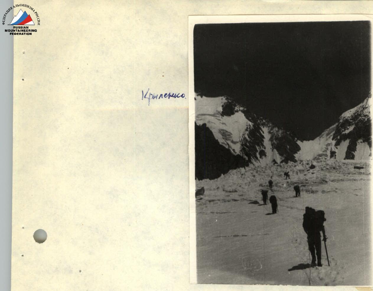
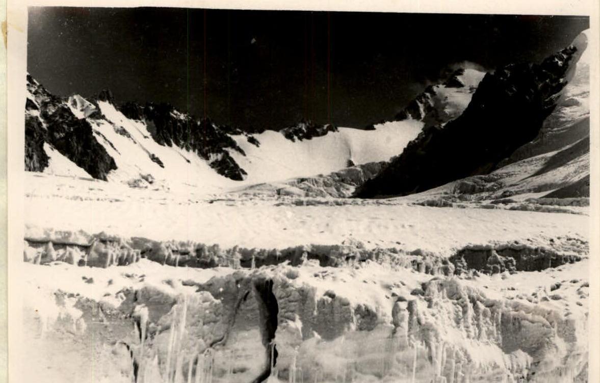
The group initially planned to ascend Pik Ficker via the route taken by the Academy of Sciences group led by Tamm (photo No. 3).
This path represents an ice wall 400-500 m high with overhangs. The Academy of Sciences group made their way with thorough protection using ice and rock anchors.
However, at the time described, the overhanging seracs posed a certain danger, so the group of climbers decided to make the first ascent via the Southwest ridge of Peak 6150 m.
III. Assault on Peak 6150 m
August 12, 1962. The assault on the peak began from the overnight stay of a group of Tajik climbers located near the foot of the Southeast ridge of Peak 6150 m, near a small mountain lake. The path straight ahead presents significant difficulties:
- rocky-ice walls.
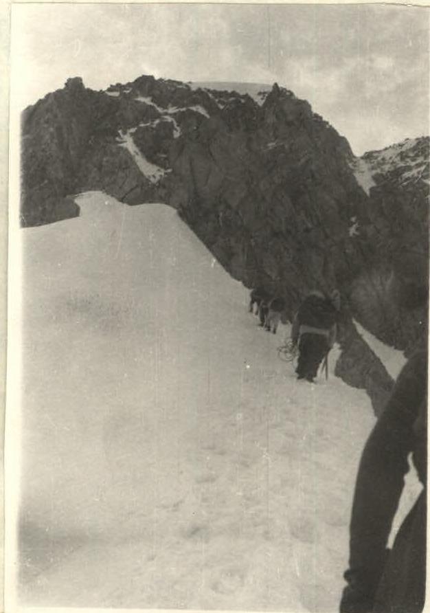
Therefore, the most acceptable path is to the right, upward, bypassing the rocky-ice walls. The path goes between large rocky fragments dusted with snow (photo No. 4, 5).
It is snowing all the time with a low drifting snow. This path (90-100 m long, 3 ropes) is quite straightforward. The slope is 35-40°. Protection is through ledges. Movement is simultaneous. The path is directly along the ridge, deviating to the left or right by several meters from the main direction (Fig. 1, photo No. 7).
We come under a crumbly wall. Under the wall, there is a small depression where one can hide from falling rocks. The height of the wall is 75 m.
The path is traversed with alternate protection by the rope team. On this section, only one team proceeds, while all others must stay in shelter due to the risk of rockfall (1).
Protection is through ledges and rock anchors. There are very few places for protection - 2-3, and the platforms are too small to accommodate the second participant.
The first member of the team traverses a section of 25-30 m, where there is a small platform to accommodate the rest of the team (2 and 3), and then continues on.
Another rope, and the wall is overcome. It is worth noting that the rocks are covered with snow, so it was necessary to clear the rocks to use handholds. The slope of the wall is 50-55°.
Next, there is a lowering of the ridge, followed by an ice slope traversed in crampons with thorough protection using ice anchors.
The path is shown in the figure. Movement proceeds from the outcropping rocks (a large stone on the lowering of the ridge) to a stone of egg-like shape, behind which, beyond a snowdrift, one can rest.
Movement is alternate, and the slope of the ice slope is up to 45°. The length of the section is 30 m.
This path is the simplest; to the right, the slope steepness increases sharply to 70-80°. Here, the path is simply dangerous due to the possibility of avalanches from above, and there is nowhere to take cover.
Before the egg-shaped stone, the slope of the ice slope increases sharply to 50°. It becomes necessary to cut steps. After the stone, for about 90 m, there follows an ice slope with an increasing slope from 65° to 70°.
Everywhere, protection is used through ice anchors, and steps are обязательно cut. Movement is only alternate. Again, there is a lowering of the ridge.
From here begins the path along snow cornices. The length of this section is 150 m.
Walking on snow cornices requires special caution and attentiveness, as in case of a fall, it is almost impossible to arrest oneself. This path is traversed with alternate protection through an ice axe.
One has to follow only this path, as descending from the ridge on either the left or right side involves ice-snow slopes with a steepness of up to 80°, making it impossible to arrest oneself in case of a fall due to the slope steepness.
These slopes become gentler only on the tributary glaciers of the Fedchenko Glacier.
The most challenging section of the pre-summit ridge is shown in the figure, photo 9. Here, snow-ice cornices begin.
From a large ice ledge, there is no other path but to lie on the ledge itself and lower oneself down, trying to reach the slope with one's feet, which lies at a distance of 1.7-2 m from the level of the ledge.
The ledge has a negative slope. One must lower oneself with their feet slightly below the ridge, as it is very narrow here and the cornice may collapse.
Protection is very thorough: under a thin layer of snow - ice. The first person lowers themselves with protection, and then lays out fixed ropes for the others to follow.
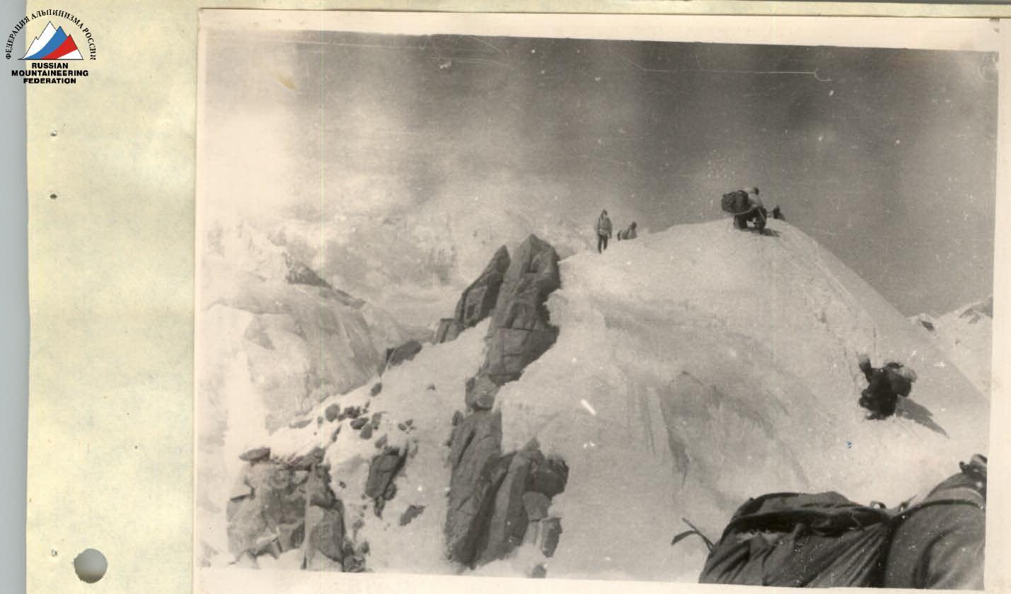
Further, the path is 80 m to a large rocky outcrop, where a cairn was built (photo No. 10) on the very summit; due to the lack of stones, it was not possible to build a cairn.
This path - cornices and a sharp ice ridge - leads to the very summit.
The first person carefully probes the path, as very often after pulling out the ice axe, the slope below the cornice was visible, so thin was the cornice. The first team of first ascenders descended from the ridge onto the slope at a rope's length - 25 m - and found a large rocky outcrop, where a cairn was built from fragments of stones, and a note from the Tajik climbers about their ascent to Peak 6150 m was left.
The remaining teams continued along the sharp snow-ice ridge to the highest point, where the altimeter showed a height of 6150 m. This was at 18:30.
Right before the summit, in the breaks of the clouds, Pik Ficker was visible. By the right of the first ascenders, Peak 6150 m was named "Peak Nikolaev-Popovich".
The descent from the summit was along the sharp ice-snow ridge, where fixed ropes were installed almost throughout (photo No. 11). An overnight stay was set up at a height of 6000 m (according to the altimeter) at 19:30, an hour's walk from the summit.
The whole night a blizzard raged, and it was necessary to get up and shake off the snow from the tents.
August 13, 1962. The storm continues. Visibility is minimal. Avalanches occur from the slopes of Pik Ficker. There could be no thought of descending from Peak 6150 m via the ascent route.
The great steepness of the slopes, the abundance of freshly fallen snow - all this made such a descent very dangerous.
The coaching council, together with M. S. A. Belopukhov, decides: descent to the Vitkovsky Glacier and from there to the camp on the Fedchenko Glacier.
It must be said that such a path had already been taken by a group led by M. S. V. Nozdryukhin. The path was made on skis and at that time of year (in spring), when the crevices on the Vitkovsky Glacier were closed.
At 7:30 in the morning, we pack up the tents and head down. After an hour, the Coaching Council decides to pitch the tents and wait out the storm. In these places, no one had been before, and orientation by map was of no use, as neither Peak 6150 m nor Pik Ficker were visible, i.e., familiar landmarks.
The whole of the previous day and night, snow had been falling. The situation became complicated, as if we waited, we would not make it back to the upper base camp by the control deadline; we did not receive signals from observers that they had received our signals; the limited amount of remaining food did not allow for a long stay; and lastly, the group had already been at an altitude of over 6000 m for two days.
At 8:00, we pack up the camp again and head towards the Vitkovsky Glacier. Visibility improves and worsens. On the way, we encounter a series of wide and deep crevices. Some of them are crossed by crawling along narrow snow bridges with thorough protection; others are circumvented.
In some crevices, it was necessary to descend to the bottom. Descent into and exit from the crevices were accompanied by cutting steps. The most significant danger and psychological difficulty in crossing the icefall are the closed crevices, of which there are many here.
Despite thorough probing with an ice axe (almost every meter was probed), there were many instances of falling into crevices. However, thanks to very attentive and reliable protection, none of the participants were injured.
Such a route continues until the descent from the icefall of the Vitkovsky Glacier. At 17:00, the group of Tajik climbers descended from the icefall. To the right, the familiar outlines of a peak are visible. A high wall, and further, Peak German Titov (6113.5 m).
Here, the path was familiar to some participants, as they had been here during rescue work searching for two climbers from the expedition of the Central Council of the "Burevestnik" Sports Society (Grebennuk and Prikhodko).
Closed crevices and rubble are encountered (photo No. 2). On the section from the icefall to the upper base camp, it is necessary not to relax one's attention; participants in the teams must move on a full rope length. At 21:00, the group arrived at the upper base camp. Comparing the route taken with all the routes of previous ascents in this and other areas, the group assesses it as a route of category 5B difficulty.
Ascents to peaks in this area: Omar-Khayyam - category 4B, Peak Gрина - category 4B, first ascent to Peak German Titov - category 4B+1.
Only this convinced us of the fairness of our assessment of the route taken on Peak 6150 m.
VIII.
List
Participants in the ascent to Peak 6150 m: Peak Nikolaev-Popovich.
| № | Surname and initials | Rank | Home address |
|---|---|---|---|
| 1. | SHUKUROV Anvar Gayratovich (leader) | 1st sports rank | Dushanbe, Gagarin St., 29, apt. 6 |
| 2. | KRYUKOV Viktor Ivanovich | 2nd sports rank | Dushanbe |
| 3. | PAN'KOV Rostislav Grigorievich | 2nd sports rank | Dushanbe |
| 4. | KORZHAVIN Leonid Ivanovich | 2nd sports rank | Dushanbe |
| 5. | LAVRUSHIN Valery Ivanovich | 2nd sports rank | Dushanbe |
| 6. | EBITCHENKO Vitaly Yurievich | 2nd sports rank | Dushanbe |
| 7. | KOZHUKHIN Yuri Mikhailovich | 2nd sports rank | Dushanbe |
| 8. | AKHMEDSHIN Mingazim Kasymovich | 2nd sports rank | Dushanbe |
| 9. | BELOPUKHOV A. | Master of Sports | Moscow |
| 10. | GUIVAN Alexander | 2nd sports rank | Kiev |
| 11. | KOPTEV Vladimir | 2nd sports rank | Kiev |
The description was compiled by:
- Belopukhov A.
- Kozhukhin Yu.
- Pekarsky V.
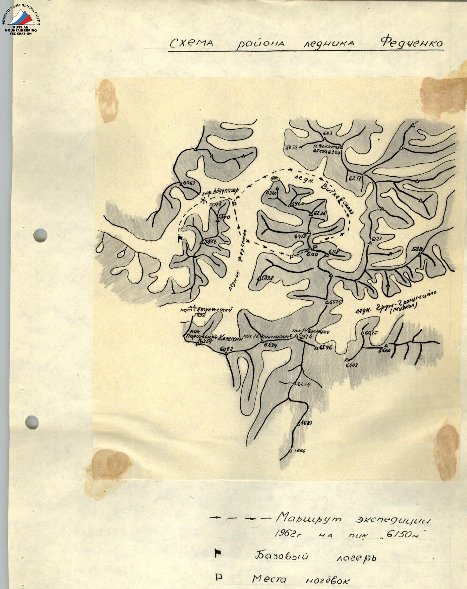
Expedition Route
1962 to Peak 6150 m
- Base camp
- Overnight stay location
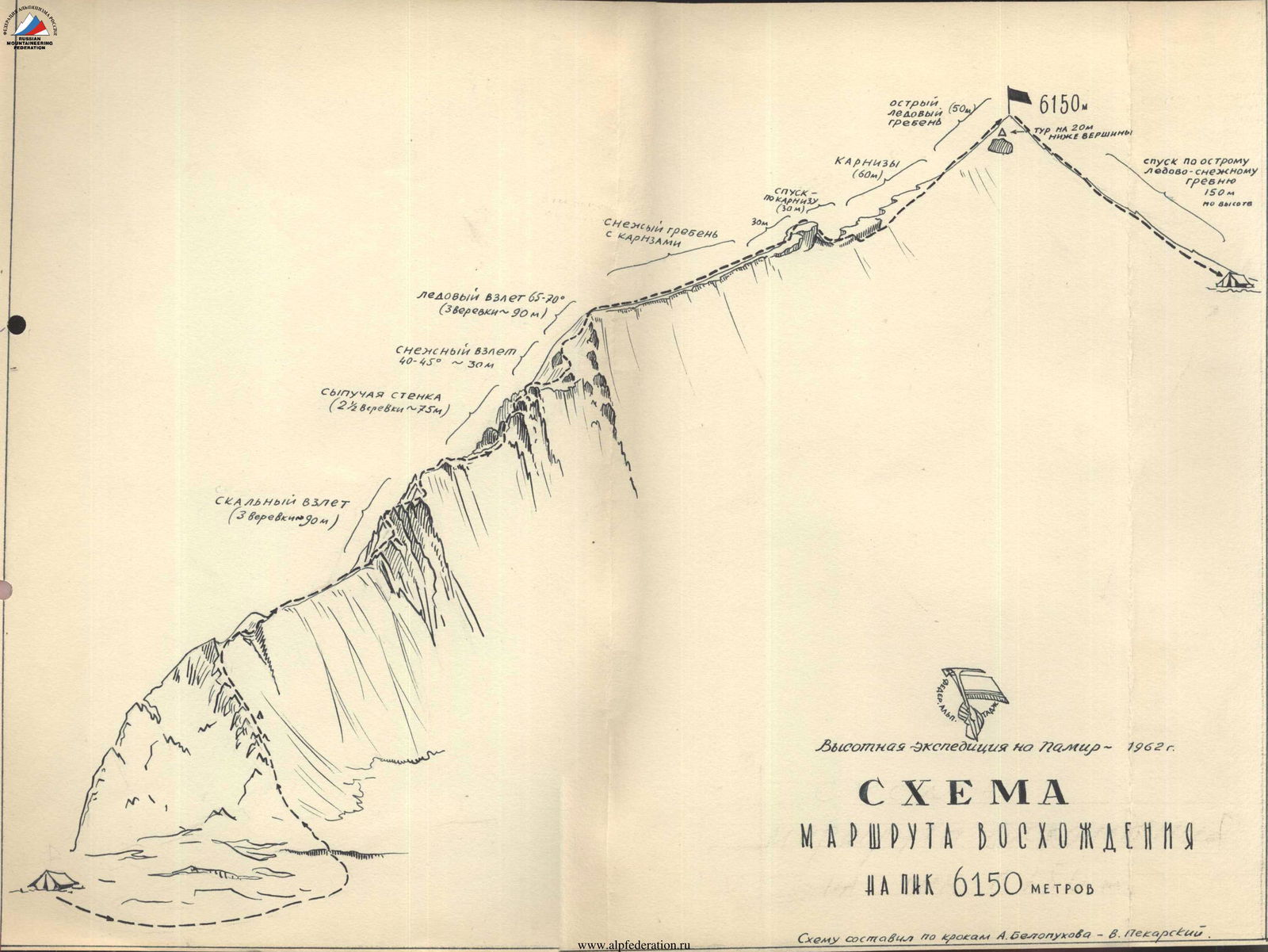
Diagram
Route of Ascent to Peak 6150 meters
Pomo No. 2 Bug on the isthmus - on the ice slope, where the outcrops of the Academy of Sciences are. Snowy summit "6150 m"
Pomo No. 2
Pomo No.3
Pomo No. 4
Pomo No. 2 Middle, 6150 m
Comments
Sign in to leave a comment