
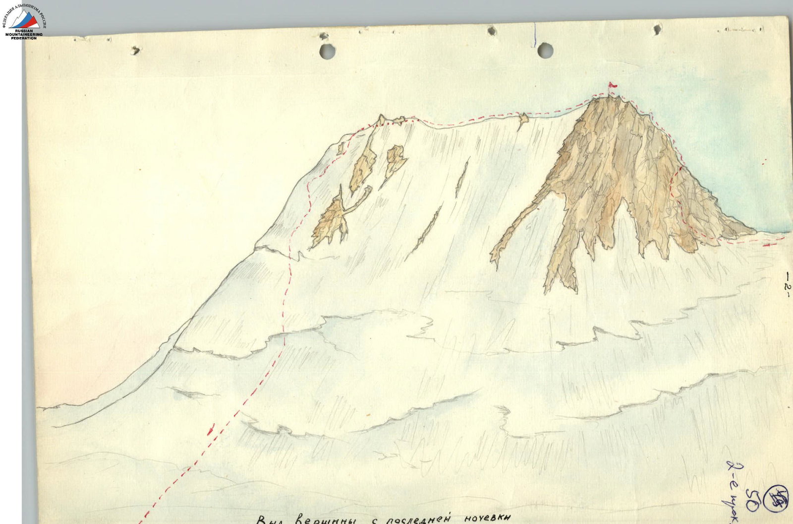
To the summit from the last overnight stay
1. Geographical Information
Peak Sovetskikh Alpinistov is located in the central Pamir in the eastern part of the Yazgulemsky Ridge in the Peak Revolyutsii massif. The average height of the ridge in this area is around 5900 m. The height of the summit is 6420 m (barometrically). The Peak Revolyutsii massif, together with Peak Sovetskikh Alpinistov and Peak Sovetskikh Profsoyuzov, crowns a grandiose cirque - the 5900 m plateau, the beginning of the Grumm-Grzhimaylo Glacier. To the south of the summit lies the Khabarvid-Khaya valley, to the east is Peak Sovetskikh Profsoyuzov, and to the west rises the massive Peak Revolyutsii.
2. Possible Ascent Routes
All possible routes to the summit of Peak Sovetskikh Alpinistov start from the 5900 m plateau of the Grumm-Grzhimaylo Glacier. There are three such paths:
- Ascending from the south via a snow-ice slope to the 6300 m col, from where you can reach the summit via rocks.
- Ascending to the same col from the north via a snowy slope with bergschrunds.
- Ascending to the summit via the north-eastern ridge.
The route from the Khabarvid-Khaya glacier is the most challenging and dangerous and is hardly passable.
Our group of 7 people completed the route in August 1960, ascending from the south to the col and then traversing to the north-east.
3. Climbing Description of the Route
From the Kokjjar tract, the last point reachable by cars, all the cargo was transported by pack camels to the base camp at 4100 m. After setting up the base camp, the organization of intermediate camps began.
To pass the first section, there are two possible paths:
- Ascending via rocks to the left of the glacier. This path is not much simpler than the path across the glacier itself, and it involves gaining an extra 150-180 m in height.
- Crossing the glacier. This path is more complicated and dangerous, but with proper preparation, it can be traversed 2-2.5 hours faster than via the rocks.
The entire glacier, when viewed from above, appears to be scored by three powerful troughs running almost through the center of the glacier's flow and reaching depths of 50-60 m. At the point where the lower part of the glacier turns east, a powerful icefall begins, which is completely impassable near the left bank (orographically). The extreme right trough has several large breaks, while the left one turns into a chaos of seracs, up to 50-70 m high, ready to collapse at any moment. Therefore, after entering the glacier, one must move perpendicular to its flow towards the opposite right bank, although this may seem unreasonable at first glance.
After descending from the coastal moraine, which is a hardened clay with large boulders pressed into it, onto the glacier, the movement occurs across the glacier covered with small stones. After 150-200 m, an icefall begins, the passage of which is made slightly upstream towards the right trough.
Overcoming the icefall requires very careful belaying, step cutting, and ice hook placement. Just before entering the trough, one has to overcome a complex ice wall about 30 m high and with a steepness of about 65-70° using ice hook belays. After descending into the trough, three more quite complex crevices had to be traversed, with the first one inevitably requiring ice hook belaying. The first time the icefall was overcome, it took 7.5 hours, but subsequently, it was traversed in 5 and even 4 hours.
The intermediate camp R1 after the base camp was located on the left bank of the moraine under Peak Schwartzenhorn. To get there, both remaining troughs had to be traversed in turn by going rightwards (section R2). There are no complex sections here, but frequent calgospores reaching waist height and deep "glasses" into which one can sometimes sink, are tiring. Camp R1 is located within 2-2.5 hours' walk after entering the trough. The height gain from the base camp is about 450 m.
The path from camp R1 to camp R2 (section R3) initially goes along the glacier, which is heavily crevassed near the left bank but entirely flat closer to the central part. Therefore, immediately after camp R1, one needs to move leftwards towards the trough, although it is tempting to follow the left-bank moraine. This moraine is indeed easy to pass, but it then leads into such a labyrinth of crevices that it takes a lot of time to find a way out to the central part of the glacier, as there is no other path.
After the path passes under the powerful wall of Peak Schwartzenhorn, one should turn again towards the left bank across what appears to be a broken glacier. It is relatively simple here, and all crevices can be avoided. The direction - towards the lower part of Schwartzenhorn's wall - leads to the moraine under the wall itself. The path along the moraine is straightforward, and there is no need for the tiresome task of knocking down calgospores. At the point where the glacier turns west, one has to move leftwards again as the moraine is lost in powerful crevices. These crevices are also avoided by moving across the central part of the glacier until and after the turn. After the turn, the path leads under Peak Uglovoy, where a night's stay is organized on the moraine (camp R2). The troughs here have a very weakly expressed character and are completely lost after the glacier turns west. The height of the overnight stay is about 5000 m. The height gain from camp R1 is about 500 m.
Further on, the path continues all the time across the glacier (section R4). The path is not complex but tiring, almost all the time across the middle of the glacier. Approximately up to a height of 5200 m, the glacier is open, its flow is relatively simple, and passing crevices does not cause difficulties. However, where snow lies, overcoming the glacier requires maximum attention due to the presence of transverse crevices. The entire section up to the upper icefall represents three gentle ascents alternating with almost horizontal sections. An overnight stay (camp R3) is organized near a small ice depression, almost in the middle of the glacier (slightly closer to the right bank) under the slopes of Peak Kharvaz. In this depression, under a thin layer of ice, there is water. The time taken to pass this section is about 6 hours, but there is no point in going further due to the lack of water. The height is about 5500 m.
The entire fourth day is spent overcoming the upper icefall (sections R5-R6). After leaving camp R3, a relatively steep snowy ascent (about 30°) is traversed. Then, one reaches the upper icefall. It is quite difficult to survey the path, but the most probable route appears to be to the right of a powerful snowy mulde at the bottom of the icefall. The path around this mulde is made as if along an arc - rightwards upwards and then leftwards - under the rocky slopes of Peak 6586 m. However, the apparent simplicity of the path is deceptive, as the ascent to the 5900 m plateau is blocked by a very deep and powerful crevice, which is entirely impassable. Therefore, after passing the first two crevices, which are widest to the left, one needs to move leftwards to be as if above the mulde. Almost in the center of the icefall, there is a huge longitudinal crevice about 70 m wide, filled with snow. To descend into it, two seracs had to be overcome using the athletic method, with the second serac inevitably resulting in a loss of height of about 50 m. When traversing snowy sections, one must always be wary of hidden crevices. After descending into the wide crevice, movement is made leftwards and upwards under a powerful overhanging serac, as there is no other path. Although the serac is relatively far - 40-50 m - the movement must be as fast as possible.
The ascent to the 5900 m plateau is via an ice wall reaching a steepness of 60° and a length of 60 m - two rope lengths. The wall is covered with a very thin layer of snow. Here, movement is mandatory with ice hook belays and step cutting. Overcoming this wall, even after installing handrails, takes about 3 hours. After reaching the relatively flat part of the glacier, within 40 minutes to 1 hour, the last intermediate camp R4 is set up. The upper icefall was only passed on the third day.
In general, overcoming the entire Grumm-Grzhimaylo Glacier, which is about 37 km long and involves a height gain of about 2000 m, requires 4 days. Movement is always in rope teams and almost always with alternate belaying in the upper part. On the plateau, a snow cave can be dug out, as the snow is very deep. The time taken to move from camp R3 to camp R4 is 7-8 hours. The height gain is about 400 m.
Camp R4 is located on the 5900 m plateau in its middle part. The next day, early in the morning, before the snow thaws, a tiring snowy section is traversed to a nameless pass. This section is fenced off to the left by Peak Sovetskikh Profsoyuzov and to the right by Peak Sovetskikh Alpinistov, so there is no wind here, it is very hot, and traversing this section is very difficult, although the height gain here is gradual and small. The snow is deep and collapses, despite an early start. Leaving Peak Sovetskikh Alpinistov to the right and moving from east to south, one needs to reach the nameless 6050 m pass. At this point, by 12:00-13:00, there is water.
The path to the col (section R9) is complex and not entirely visible. A bergschrund is overcome via a snowy bridge, immediately after which a complex slope with flowed ice begins, reaching a steepness of up to 45°. Here, 2 ice hooks were hammered in. The path is complicated by the presence of longitudinal crevices. After traversing 100-150 m of such a slope (in length), the path transitions to a snowy slope, also reaching a steepness of 45°. Movement is cautious because here, a small traverse is made from right to left, and it is very easy to knock off snowy steps. At this point, there is also a risk of an avalanche, especially after a fresh snowfall. The length of this section is about 250-300 m. Just before reaching the 6300 m saddle, another bergschrund is overcome, which runs from top to bottom, from left to right. The bergschrund is most passable in its upper part. It should be remembered that it is significantly larger than it appears. From below, careful belaying is mandatory. The time taken to pass this section is at least 2-3 hours. The 6300 m col is wide and convenient for organizing an intermediate camp.
Further on, the path is well visible. From the col, it goes rightwards, initially through deep snow, then across firm firn, which leads to an 80-90-meter rock wall. Movement along it occurs with careful ice hook belaying; the rocks are old and crumbly, so movement in a large group is not recommended. On the wall, 2-4 rock hooks are hammered in. After the wall, there is a group of small rocky gendarmes about 5-6 m high, composed of very destroyed rock. They are overcome by cautious climbing with careful belaying. The length of this section is about 60 m. The time taken to traverse from the col is about 2 hours.
Immediately behind the gendarmes, the path becomes gentler and, transitioning to talus, leads to the summit cairn. 200-250 m to the east, another summit was discovered, and it was difficult to determine which one was higher. When moving towards the second summit, the path went along a very sharp snow-ice ridge, dropping off on both sides at 60-70°. The ridge slopes are snow-ice with individual rocky outcrops. Traversing the ridge is complicated by the fact that:
- from the south side, it is thawing;
- from the north, it is very hard, turning into flowed ice in places.
Therefore, it was necessary to cut off the upper ridge crest along the entire length. Movement is with careful alternate belaying via an ice axe. The ridge is traversed in 2 hours.
In several places where belaying via an ice axe was impossible, several ice hooks had to be hammered in.
On the ridge, in two places, there are gendarmes composed of heavily destroyed rocks about 5-6 m high. The gendarmes are overcome head-on.
There was no cairn on the second summit.
The descent from the second summit began along the north-eastern ridge directly onto the plateau. The snow here lies very densely in places and very loosely in others, so that one sinks waist-deep. The slope is avalanche-prone, so one should not move leftwards towards the rocks, as avalanche cones and snow-ice dumps are visible from below. The slope reaches 25-35° in steepness, and it is particularly tiring to walk through loose snow, making it difficult to organize belaying.
The first bergschrund is easily overcome because the snow is firm at this point. The bergschrund is overcome by jumping over.
The second bergschrund is more dangerous as it is traversed via a snowy bridge made of loose snow.
The descent from the summit to the 5900 m camp takes 2.5-3 hours. When repeating this route, it is recommended to set up an intermediate camp on the 6300 m col, as in case of worsening meteorological conditions, it is difficult to reach the 5900 m camp before nightfall.
For the ascent from the 5400 m camp, at least 3 days are required. For traversing the summit from the 5900 m plateau and returning to it, more than 11 hours are needed. In total, for the ascent from the base camp, 6-7 days are required.
4. Assessment of the Route's Difficulty
The route is combined: snow-ice-rock, high-altitude. In a note found on the summit, the group of first ascenders led by K. Kuzmin, who made the ascent via the described route in 1954, assessed the route as category 4B difficulty.
The traverse can be quite reasonably assessed as category 5A difficulty and is recommended as good training before attempting Peak Revolyutsii from the Grumm-Grzhimaylo Glacier via any path.
Head of the assault group V.P. Soustin November 12, 1960
Table
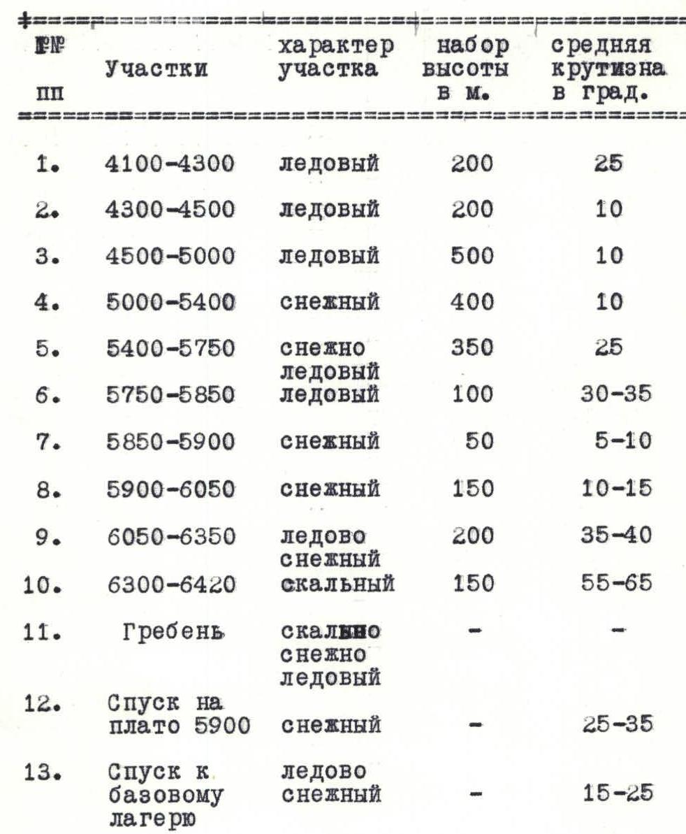
| № | Section | Character of the section | Height gain, m | Average steepness, ° |
|---|---|---|---|---|
| 1. | 4100–4300 | ice | 200 | 25 |
| 2. | 4300–4500 | ice | 200 | 10 |
| 3. | 4500–5000 | ice | 500 | 10 |
| 4. | 5000–5400 | snow | 400 | 10 |
| 5. 6. | 5500–5750 | snow-ice | 350 | 25 |
| 7. | 5750–5850 | ice | 100 | 30–35 |
| 8. | 5850–5900 | snow | 50 | 5–10 |
| 9. | 5900–6050 | snow | 150 | 10–15 |
| 10. | 6050–6350 | snow-ice | 200 | 35–40 |
| 11. | 6300–6420 | rocky | 150 | 55–65 |
| 12. | Ridge | snow-ice-rocky | — | — |
| 13. | Descent to 5900 plateau | snow | — | 25–35 |
| 14. | Descent to base camp | snow-ice | — | 15–25 |
Table (continued)
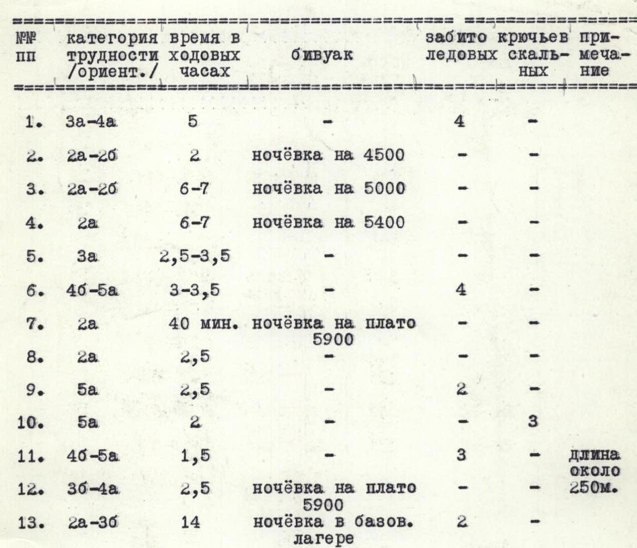
| № | Category of difficulty (approx.) | Time in walking hours | Camp | Number of hooks driven (ice/rock) | Note |
|---|---|---|---|---|---|
| 1. | 3A–4A | 5 | — | 4 / — | |
| 2. | 2A–2B | 2 | overnight stay at 4500 m | — / — | |
| 3. | 2A–2B | 6–7 | overnight stay at 5000 m | — / — | |
| 4. | 2A | 6–7 | overnight stay at 5400 m | — / — | |
| 5. | 3A | 2.5–3.5 | — | — / — | |
| 6. | 4B–5A | 3–3.5 | — | 4 / — | |
| 7. | 2A | 40 min | overnight stay on 5900 m plateau | — / — | |
| 8. | 2A | 2.5 | — | — / — | |
| 9. | 5A | 2.5 | 2 / — | — | |
| 10. | 5A | 2 | — | — / 3 | |
| 11. | 4B–5A | 1.5 | — | — / 3 | length about 250 m |
| 12. | 3B–4A | 2.5 | overnight stay on 5900 m plateau | — / — | |
| 13. | 2A–3B | 14 | overnight stay in base camp | 2 / — |

Comments
Sign in to leave a comment