1. Ascent Passport
- Region: Yazgulemsky ridge (Central Pamir).
Valley: Yazgulem. Section number according to the 1999 classification table – 4.12.
- Summit name: Peak Rokzou.
Route name: from Rokzou Glacier via the serac zone of the southwestern slope.
- Proposed – category 4A, first ascent.
- Route type: snow and ice.
- Elevation gain: 1320 m (by altimeter).
Route length: 4400 m.
Length of sections:
- category V – 0 m.
- category VI – 0 m.
Average steepness:
- main section of the route – 20°
- entire route – 17.85°
- Pitons left on the route:
total – 0; including, drilled pitons – 0. Pitons used on the route: 14.
- Drilled stationary pitons – 0, including, ITO – 0.
- Drilled removable pitons – 0, including, ITO – 0.
- Total ITO used – 0.
- Team's climbing hours: 13 h 30 min, 2 days.
- Leader: Lebedev Andrey Alexandrovich.
Team members:
- Gushchin Mikhail Yuryevich
- Dubinin Viktor Leonidovich
- Loginov Valery Mikhailovich
- Maslennikov Alexey Vasilievich
- Osokin Vasily Viktorovich
- Pigulevsky Alexey Konstantinovich
- Popov Vadim Anatolyevich
- Coach: Lebedev Andrey Alexandrovich.
- Departure to the route: 7:30 AM July 30, 1990.
Summit reached: 5:10 PM July 31, 1990. Descent to Fedchenko Glacier after traversing the summit: 6:10 PM August 1, 1990.
2. Photographs of Peak Rokzou from different sides
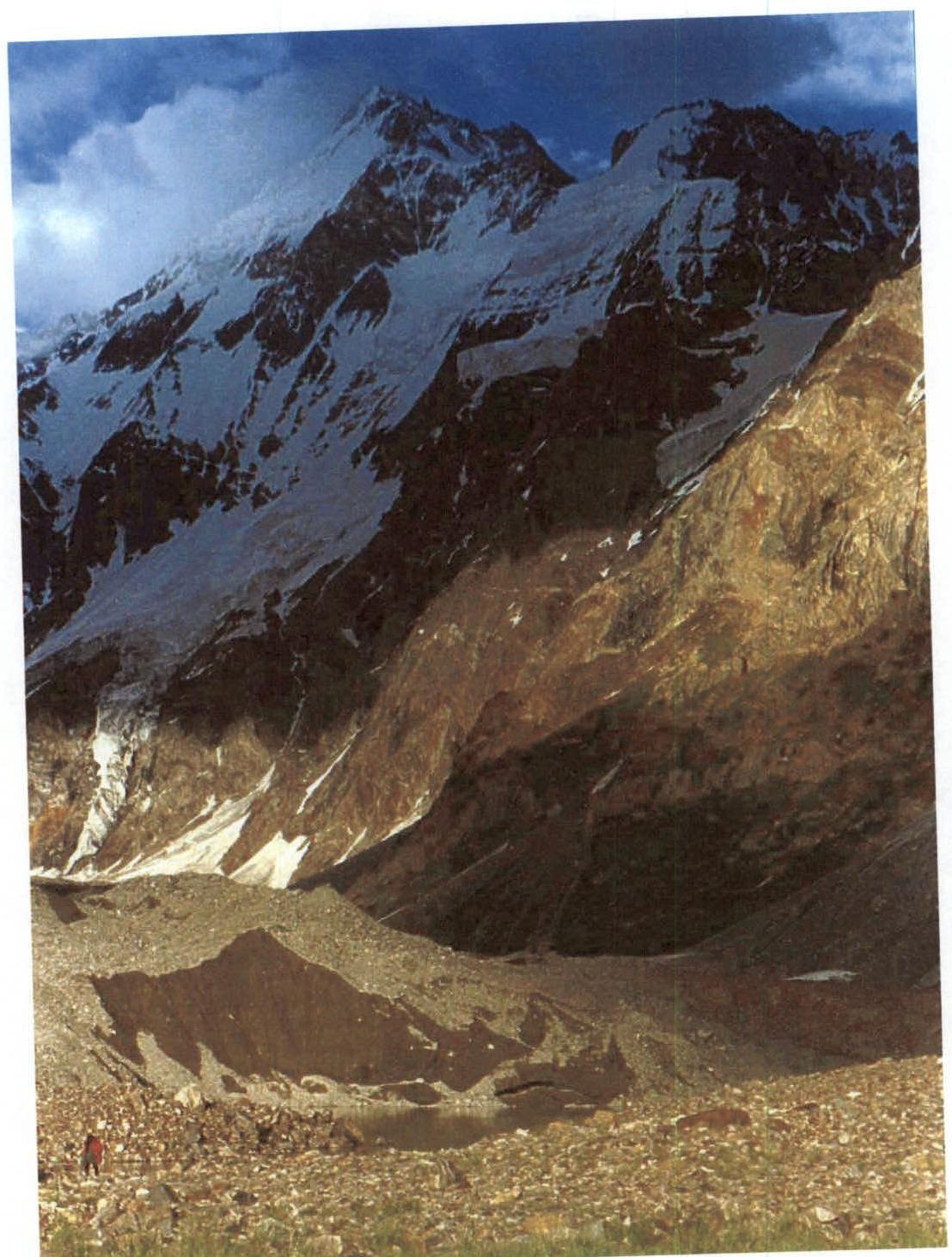 Fig. 1. View of Peak Rokzou from the northwest from the left moraine of Yazgulemsky Glacier (camera height 3653 m). Photo taken on August 2, 1999.
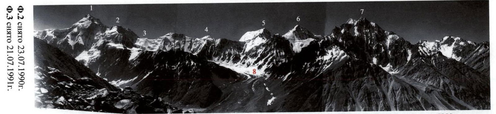 Fig. 2. View of Peak Rokzou from the northwest from the Vanch ridge.
1 – p. Rokzou 6251; 2 – west shoulder of p. Rokzou 5650; 3 – pass Odessa 5280; 4 – pass Odessa-2; 5 – p. 5471; 6 – p. 5721; 7 – p. 5271; 8 – Zaharchenko Glacier.
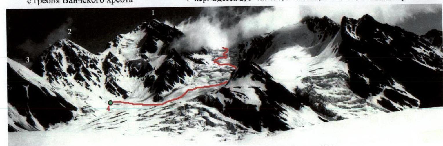 Fig. 3. View of Peak Rokzou from the southwest from Rokzou Glacier.
1 – p. Rokzou 6251; 2 – west shoulder of p. Rokzou 5650; 3 – pass Odessa 5280; 4 – start of the route 4930.
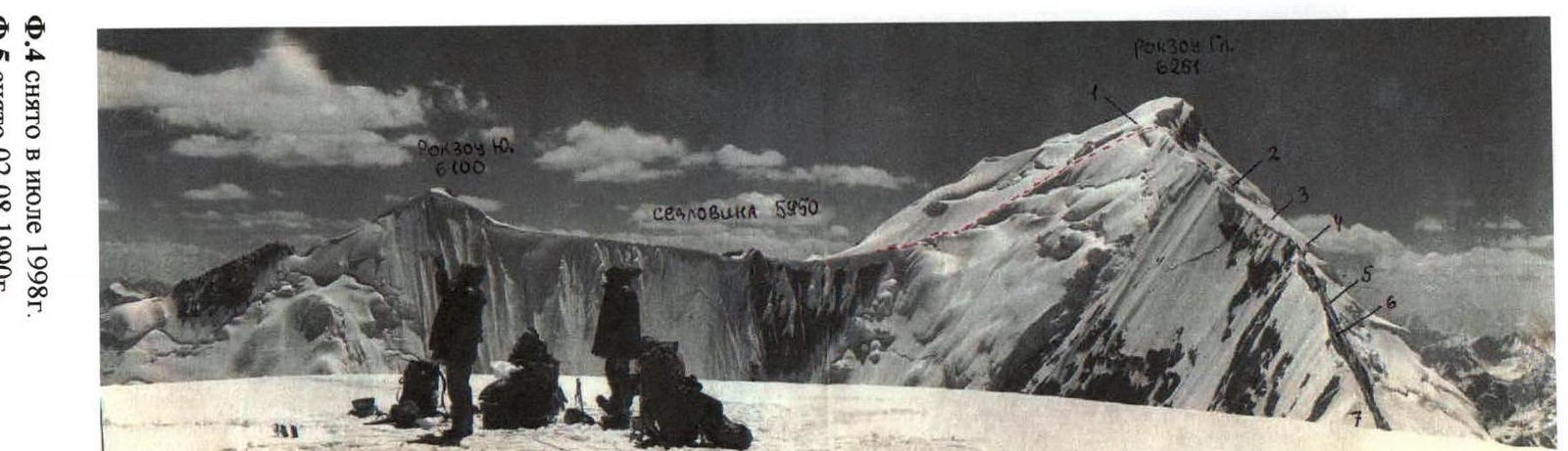 Fig. 4. View of Rokzou massif from the east from peak 5921.
1 – pass Pлечо Рокзоу 6150 m; 2 – ice gendarme; 3 – ridge with bilateral cornices; 4 – pillow; 5 – knife; 6 – rocky gendarme. The eastern ridge has been explored but not climbed.
 Fig. 5. View of p. Rokzou from the northeast from Fedchenko Glacier.
1 – pass Плечо Рокзоу; 2 – ice gendarme; 7 – pass Рокзоу.
3. Area Map
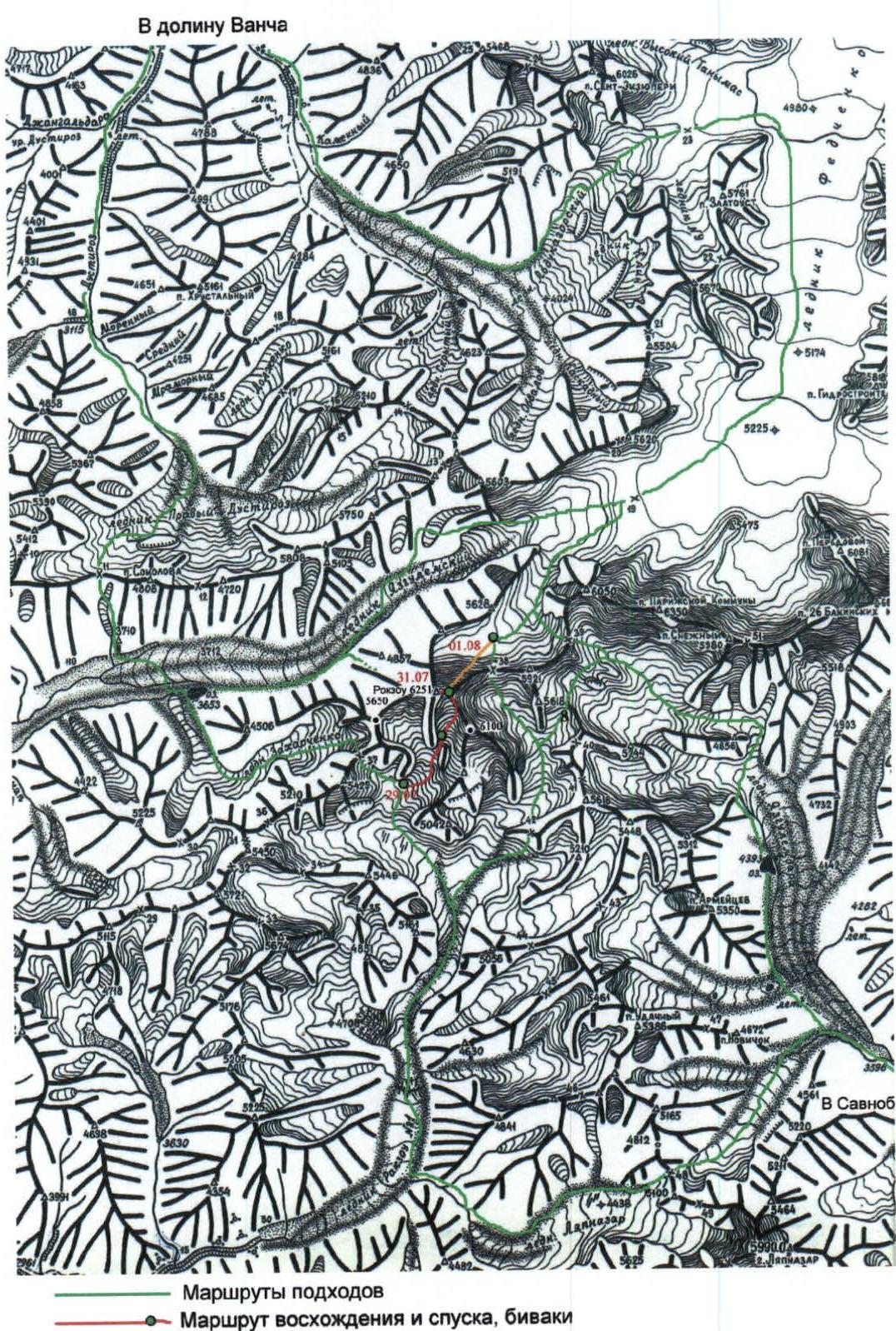 On the map:
- 23 – pass Abdugor
- 11 – pass MVТУ
- 37 – pass Odessa
- 48 – pass Nizhny Khurdzhin
- 19 – pass Yazgulemsky
- 39 – pass Verkhny Khurdzhin
- 38 – pass Rokzou
- 8 – pass Sredny Khurdzhin
4. Area Overview
Peak Rokzou (6251) is located in the western spur of the Yazgulemsky ridge between the two headwaters of the Yazgulem River — Mazardara and Rokzou. This is the easternmost "six-thousander" in the wall of p. Revolyutsiya — p. 26 Baku Commissars — p. Paris Commune — p. Rokzou, which drops into the Mazardara valley with a 2500-meter wall, see Fig. 1. The summit has three peaks. There is no information about ascents to the southern summit (~6100 m), see Fig. 4, and to the western shoulder of Peak Rokzou (~5650 m), see Fig. 2 and 3. The lack of attempts to climb Peak Rokzou is explained by its significant remoteness from roads and difficulty of approach.
Paths to the summit:
- From the Vanch River valley through pass Abdugor along Fedchenko Glacier — to the northeastern wall and to the eastern ridge of the summit, see Fig. 5.
- From Savnob up the Yazgulemdara — to pass Verkhny Khurdzhin, to the start of the traverse: p. 5921 — eastern ridge of Rokzou — p. Rokzou.
- From the Vanch River valley through pass MVТУ — to the lake 3653 m near the left moraine of Yazgulemsky Glacier, then to the foot of the northern wall, see Fig. 1 and Fig. 6.
- From the lake 3653 m through pass Odessa, see Fig. 2, — to Rokzou Glacier, to the foot of the southwestern slope of the summit, see Fig. 3.
- The route along the southwestern slope can also be approached from Savnob through pass Nizhny Khurdzhin and the serac zone of Rokzou Glacier.
Our expedition proceeded from the Vanch valley through passes MVТУ and Odessa and established a base camp (4930 m) on the shore of a glacial lake at the base of the southern buttress of the western shoulder of Peak Rokzou, see Fig. 3.
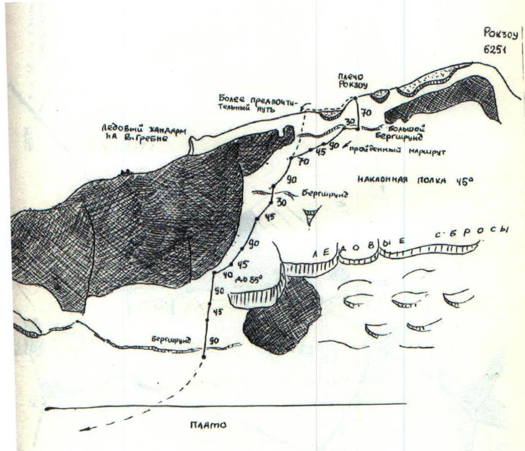
5. Technical Photographs of the Route
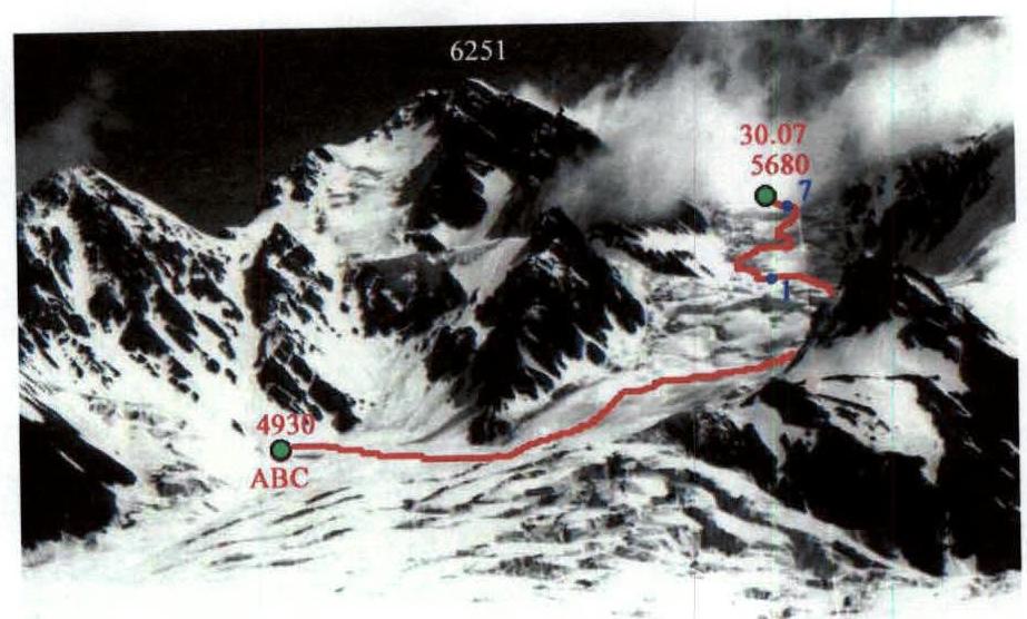 Fig. 7. Start of the route to Peak Rokzou along the serac zone of the southwestern slope. Sections R1–R7.
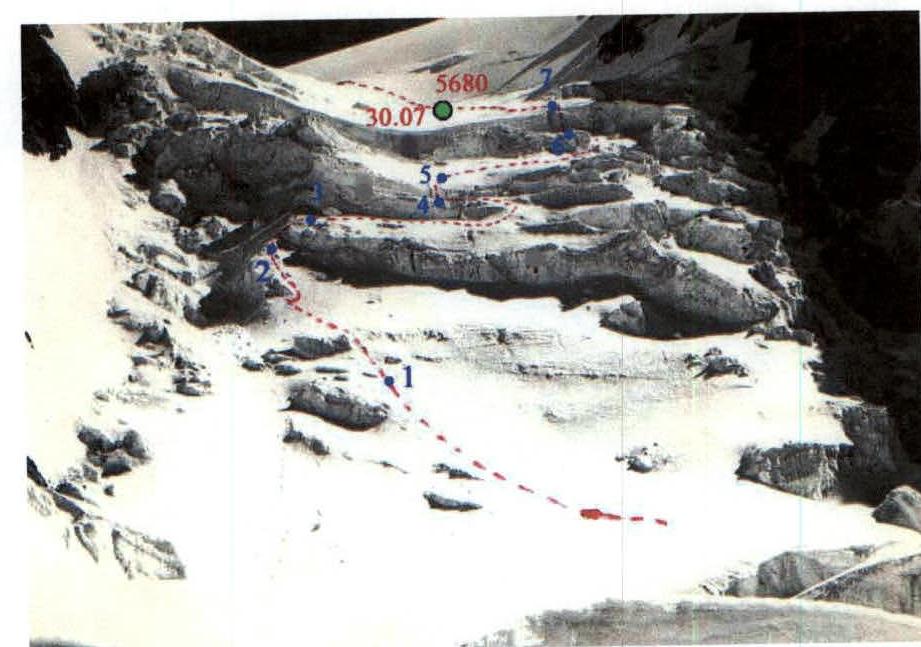 Fig. 8. Serac zone of the southwestern slope of Peak Rokzou. Sections R2–R7.
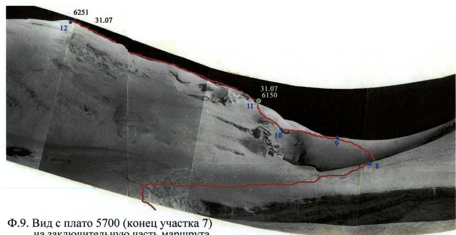 Fig. 9. View from the plateau 5700 (end of section R7) to the final part of the route.
6. Route Sections Table
| № | Section Name | Start Height | End Height | Photo | Difficulty | Length (m) | Steepness (degrees) |
|---|---|---|---|---|---|---|---|
| 12 | Wide ridge | 6150 | 6251 | Fig. 9, Fig. 4, Fig. 12 | 1 | 430 | 15 |
| 11 | Snow slope | 6000 | 6150 | Fig. 9, Fig. 4 | 2 | 290 | 30, местами 40 |
| 10 | Wide ridge | 6000 | 6000 | Fig. 9, Fig. 4 | 1 | 300 | 0 |
| 9 | Snow and ice slope | 5885 | 6000 | Fig. 9 | 2 | 200 | 35 |
| 8 | Snow plateau | 5680 | 5885 | Fig. 9 | 1 | 700 | 15–20 |
| 7 | Ice wall | 5665 | 5680 | Fig. 8, Fig. 10, Fig. 11 | 4 | 15 | 90 |
| 6 | Snow and ice ledge | 5635 | 5665 | Fig. 8, Fig. 10 | 1 | 150 | 10–12 |
| 5 | Ice wall | 5595 | 5635 | Fig. 8, Fig. 10 | 3 | 50 | 45, at the top 60 |
| 4 | Snow and ice ledge | 5575 | 5595 | Fig. 8, Fig. 10 | 1 | 95 | 10–12 |
| 3 | Ice counterfort (breakdown slope) | 5535 | 5575 | Fig. 8, Fig. 10 | 4 | 50 | 50, местами 60 |
| 2 | Snow and ice slope | 5450 | 5535 | Fig. 8, Fig. 10 | 3 | 120 | 40, местами 50 |
| 1 | Approach to serac zone (closed glacier) | 4930 | 5450 | Fig. 7 | 1 | 2000 | 20 |
8. Photo Illustrations
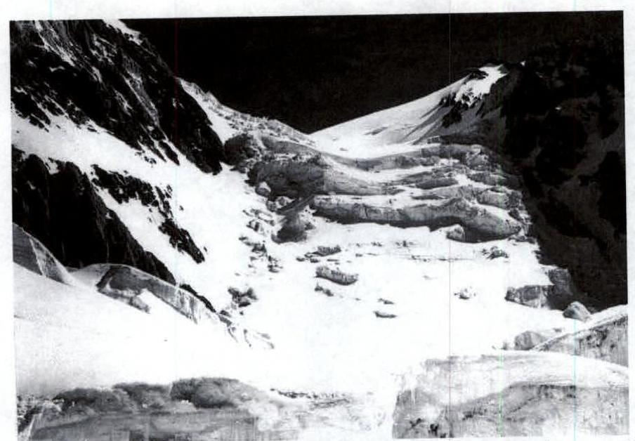 Fig. 10. Serac zone with key sections of the route (sections R2–R7).
To the right above the plateau rises the southern summit of Rokzou 6100 m.
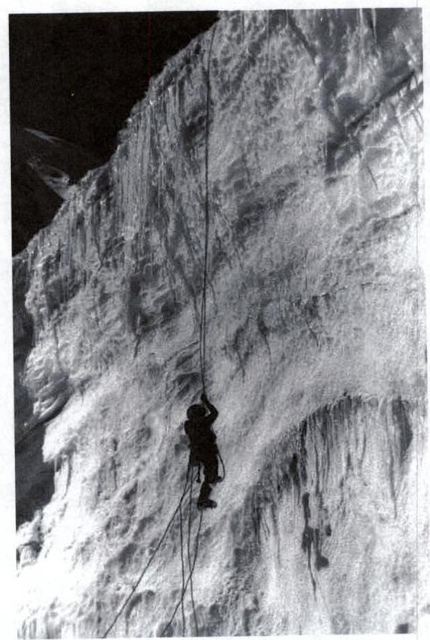 Fig. 11. Overcoming section R7. The first person navigated this wall in a dangerous randkluft (in a "cauldron") on the orographic left side, with difficult crevasses and falling seracs.
 Fig. 14. At the start of the descent from p. Rokzou to Fedchenko Glacier.
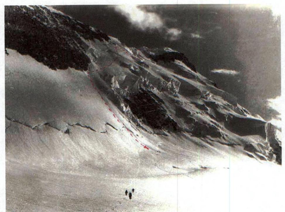 Fig. 15. Descent path from Peak Rokzou to Fedchenko Glacier.
10. Descent Diagram from Rokzou to Fedchenko Glacier