Passport
- High-altitude class.
- Pamir, Yazgulyam Range, Yazgulyam-Dara valley.
- Peak Revolyutsii, East summit (6930 m) via the South Ridge.
- Difficulty category — 5A (estimated).
- Height difference 1030 m, length — 2500 m.
Length of sections with 5-6 difficulty category — 30 m. Average steepness of the main part of the route — 45°.
- Pitons driven:
rock 30/0 bolts 0/0 nuts 20/0 ice screws 5/0
- Travel days — 4, approach and return to the camp — 8 days.
- Overnights — 3, bivouacs on snow-covered rock shelves.
- Leader — Lyudmila Varzhapetyan — Master of Sports
Participants:
- Vladimir Prosikhin — Candidate for Master of Sports
- Dmitry Belov — Candidate for Master of Sports
- Igor Golubev — Candidate for Master of Sports
- Dmitry Kirin — Candidate for Master of Sports
-
Coach: Lyudmila Varzhapetyan, Master of Sports.
-
Departure to the route from the base camp — August 8, 1987, summit — August 15, 1987, return to the base camp — August 19, 1987.
-
The ascent was organized by the expedition of Leningrad State University Climbing Section, group of the Alpine Section of Leningrad State University named after A. A. Zhdanov.

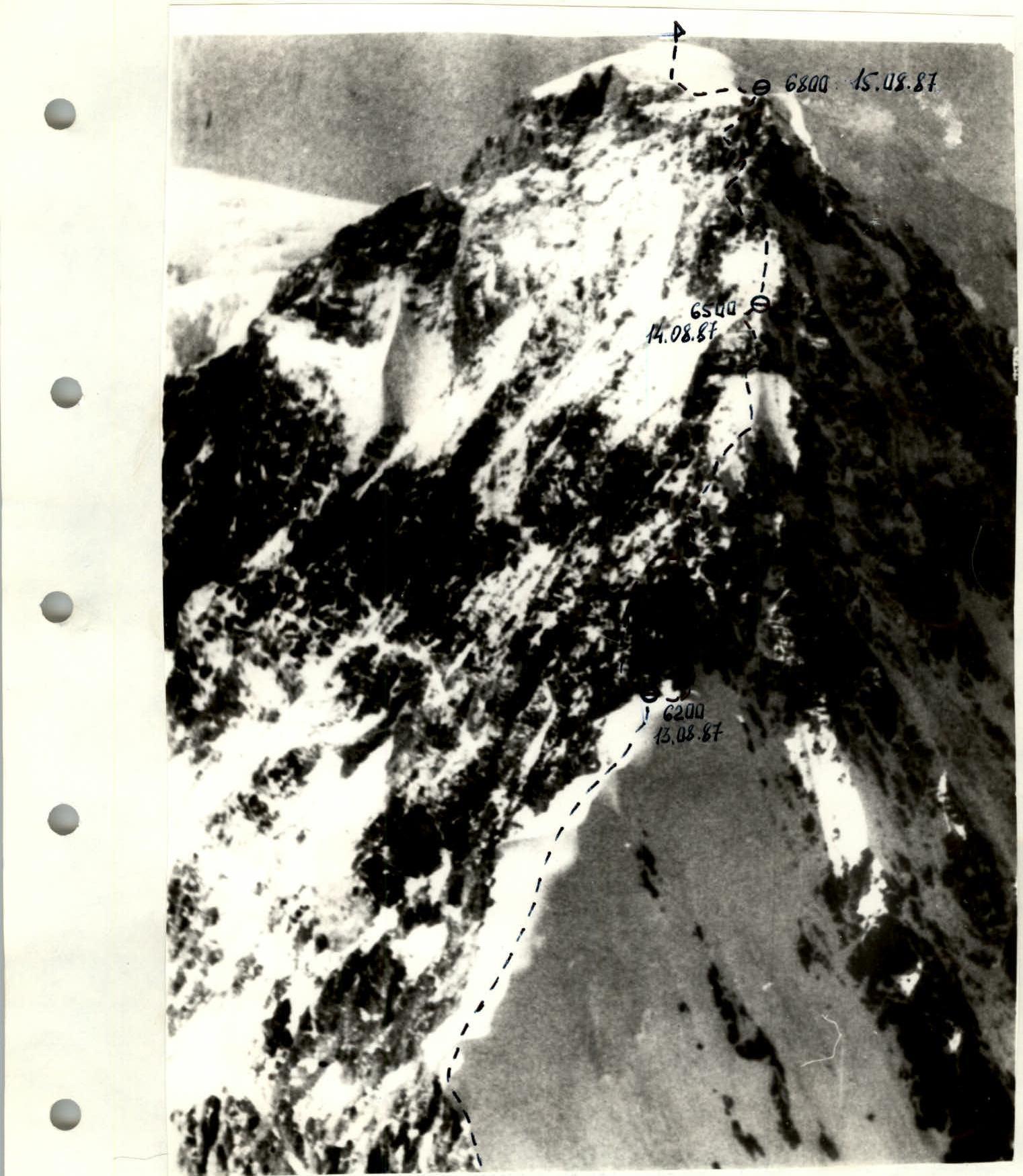
General view of the summit. The group's route is indicated.
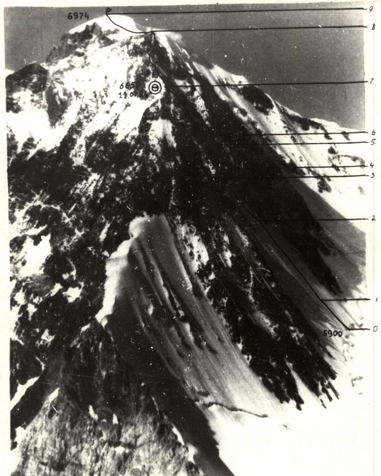
Profile of the S-W wall of Peak Revolyutsii. The photo was taken from the south, from the summit of Peak Shipka, 6254 m, at 15:00. Distance 3.5 km. Lens 150 3.5/50.
Photograph of the South Ridge of Peak Revolyutsii from the report of the ascent of 5B category by the group of V. Balyberdin in 1984. The route of Balyberdin's group is shown.
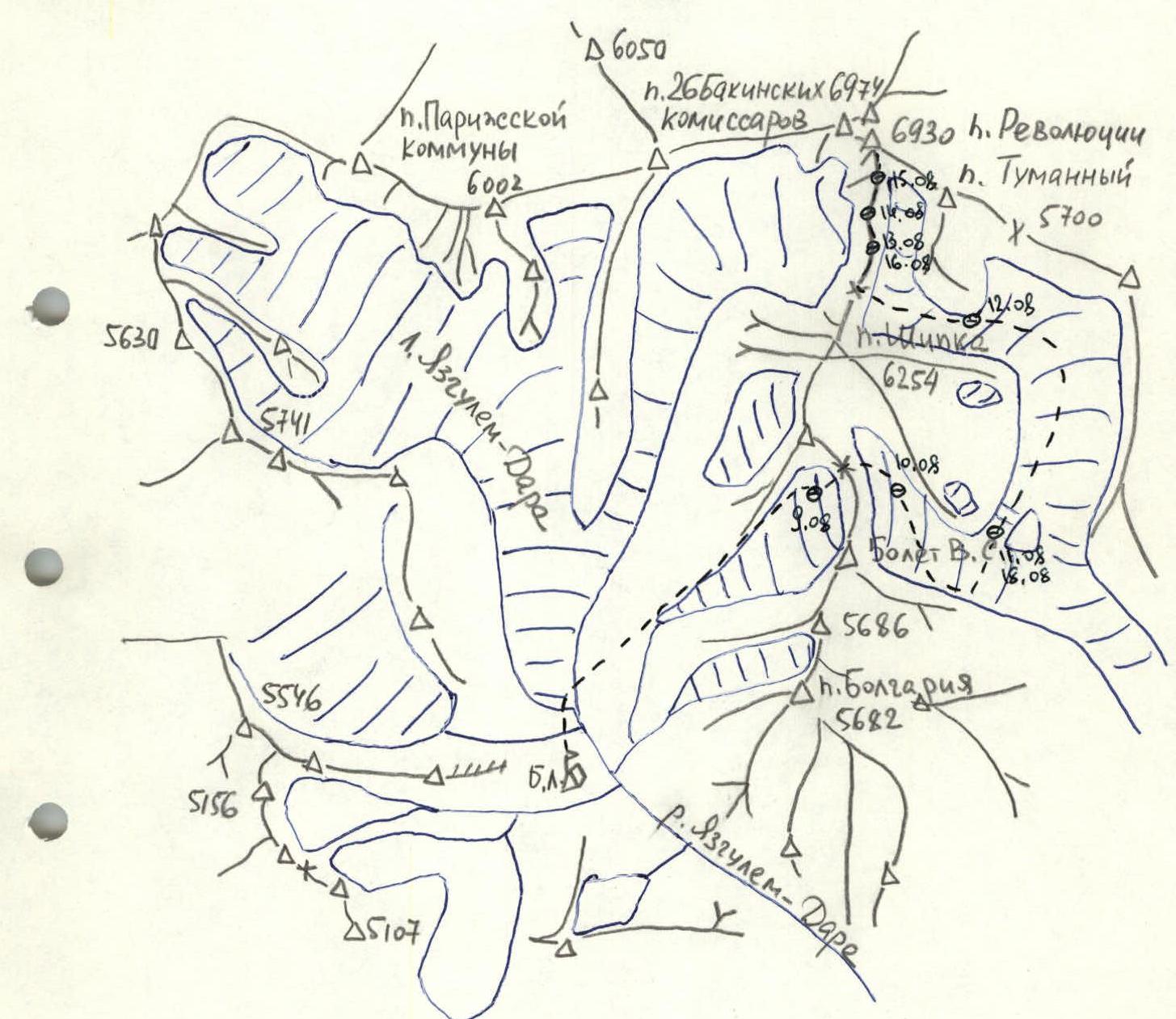
LARGE-SCALE MAP OF YAZGULEM-DARA VALLEY
Scale 1:100 000 — group's route
Description of the approach to the route
From the base camp 3700 m — helicopter landing site on the right bank of the Yazgulyam-Dara river — up the trail to the tongue of the Yazgulyam-Dara glacier covered with deep moraine deposits. Cross from the right to the left (orographic) bank of the glacier, crossing the high ridges of lateral moraines (1 h).
Northeast across the hilly grassy plain to the tongue of the glacier flowing from the Shipka pass (1 h). Up the right (orographic) couloir to the upper cirque of the glacier (2 h). Overnight stay (4400 m).
Ascent to the pass via the right snow couloir with a steepness of 40° (3 h). Avalanche danger, firn, ice, crampons required. Overnight stay possible on the Shipka pass (5200 m).
Descent: 8 ropes, fixed rope, through the center of the serac zone with an average steepness of 60° (4 h). Four overhanging sections require rappelling (4-8 m). Avalanche danger, a slab avalanche occurred during descent. Fresh traces of ice falls. 5 ropes left for the return journey. Overnight stay in the cirque below the pass.
Down through the flat cirque of the Shipka glacier (30 min), bypassing the serac zone on the right (1.5 h). In the middle part of the serac zone, the Shipka glacier is joined from the left by a short steep serac from the lateral branch of the Khabarviv-Khach glacier, and then by a longer and more complex serac from the main branch of the same glacier. The branches are separated by a 200 m high rock island, steep on the side of the Shipka glacier. Climb should be done via the left branch. The broken Shipka glacier is crossed opposite the rock island. Overnight stay in the cirque below the serac (4500 m).
Serac zone: 6 ropes, average steepness 55°, better to pass in the morning due to possible ice falls from the hanging glacier on the left (fresh traces). On the serac zone — one and a half ropes of 60° ice, narrow snow bridges.
Up the closed glacier to a low snow saddle between the rock island and the slopes of Peak Shipka (1 h). 100 m down to the main branch of the Khabarviv-Khach glacier.
Up the center of the broken glacier to the confluence of the two feeding branches below the slopes of Peak Tumanny (2 h). Overnight stay.
Below the slopes of Peak Tumanny — along the glacier to the upper cirque below the S ridge of Peak Revolyutsii (5700 m), below the ridge connecting Peak Revolyutsii and Peak Shipka (2-3 h). Exit to the ridge at its lowest point. No bergschrund at this slope.
Return to the base camp via the approach route.
UIAA SCHEME
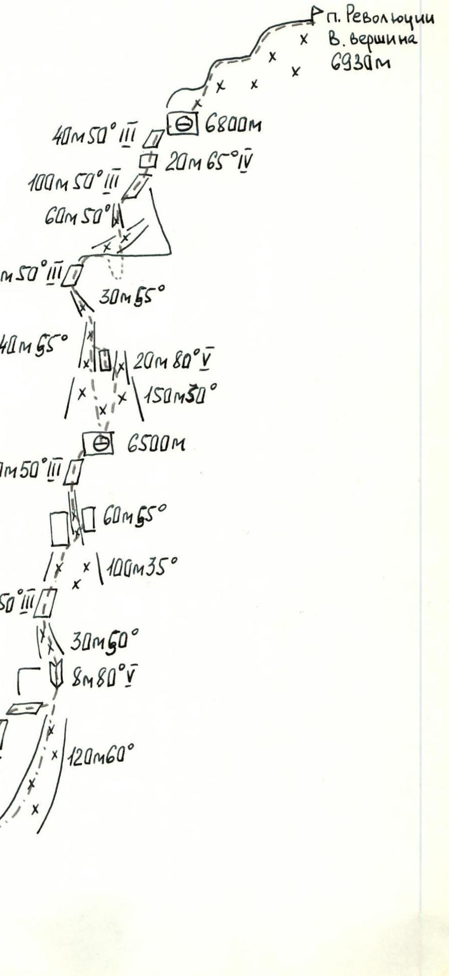
Explanation of the scheme
The route begins from the ridge connecting Peak Revolyutsii and Peak Shipka (5900 m). Up to 6200 m, the ridge is snow-covered with occasional rock and ice outcrops. Snow sections with a steepness of 40-50°. Simultaneous movement in rope teams.
Convenient overnight stay at 6200 m on a large snow-covered platform below the rocks.
From the overnight stay, 6 ropes of steep snow-covered rocks along the ridge. Traverse right 15-20 m below a vertical wall. Ascent up a complex smoothed internal angle and inclined shelves. A steep snow couloir with ice leads to the ridge. After a rope length of steep rocks — exit to a wide snow section of the ridge. Along the wide ridge — to a steep snow-ice couloir. Pitons initially on the left rock wall, then on the right wall of the couloir. After a short rock section of the ridge — overnight stay on a wide snow-covered shelf.
Above — another section of the wide ridge. Up a steep snow slope — to the right of two couloirs. Cross left-up complex icy rocks and exit to the middle part of the steep left snow-ice couloir. Possible exit from the slope directly via the left couloir. Up the couloir. After turning left, the couloir leads to the rock ridge. Up the ridge with 2-3 m steps, after a horizontal section of the ridge (40 m) — left traverse of the couloir descending from the ridge towards the Yazgulyam-Dara glacier, via a steep snow-ice couloir to a rock rib, 100 m above joining the main ridge. Up steep rocks — to the summit plateau.
Here, convenient overnight stay at 6800 m. Almost the entire section of the ridge from 6200 to 6800 m — piton protection, fixed ropes. On gentle sections and the summit cap — deep snow.
From the overnight stay to the E summit — 1 h of simultaneous movement in rope teams.
Descent via the ascent route (section 6800-6200 m — about 6 h). Convenient descent option on the section 6350-6200 m — via the ice couloir on the left (3 ropes rappelling).