Ascent Log
I. Ascent Class - High-altitude 2. Ascent Area - Pamir, Yazgulem Range 3. Object of Ascent - Peak Revolyutsii - 6974 m, first ascent from the Khabarviv-Khats glacier via the counterfort of the South Face 4. Estimated Difficulty Category - 5B 5. Route Characteristics:
| Height Difference | 1700 m |
|---|---|
| Average Steepness | 45–50° |
Section Lengths:
- R2 — 120 m
- R3 — 525 m
- R4 — 520 m
- R5 — 700 m
-
Pitons Driven for Belaying: ice - 7 pcs., rock - 30 pcs.
-
Number of Climbing Hours - 39 hrs (base camp - summit), 18 hrs (from the bergschrund)
-
Number of Overnight Stays - 5 (in convenient locations)
-
Group Composition: Ivanova Tatiana Vasilievna — CMS, leader Ivanov Valentin Andreevich — MSMS, participant Kostin Boris Ilyich — MS, —"— Smirnov Rudolf Nikolaevich — MS, —"—
-
Team Coach: Honored Master of Sports Ovchinnikov Anatoly Georgievich
-
The group started the route on July 28 and returned on August 2, 1979.
1. Brief Geographic Characteristics of the Area.
Description of the Ascent Object.
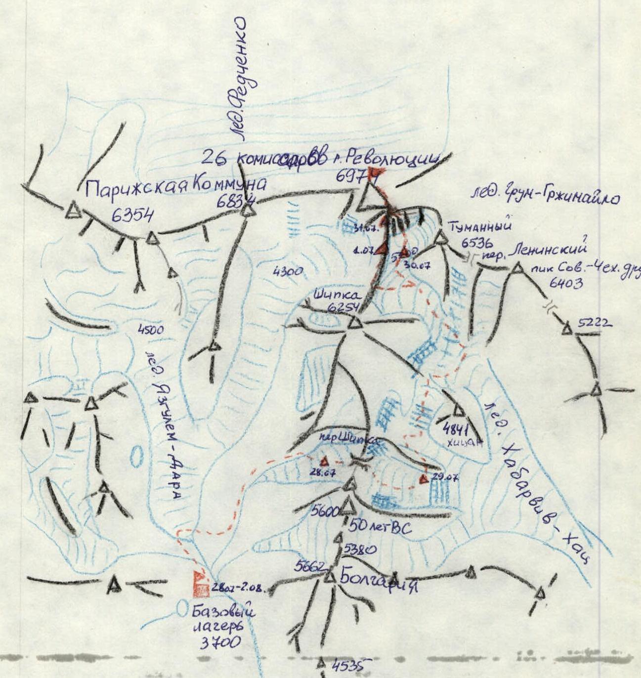
In the geographic center of the Pamir lies the sixth highest peak in the USSR - Peak Revolyutsii (6974 m), surrounded by powerful glaciers. Its slopes are drained by the Fedchenko Glacier to the north, the Grum-Grжимайло Glacier to the east, and the Yazgulem-Dara and Khabarviv-Khats glaciers to the south.
The Yazgulem Range east of its junction with the Academy of Sciences Range reaches its maximum height, enclosing the Fedchenko Glacier from the south with the peaks:
- Parizhskaya Kommuna - 6354 m,
- 26 Baku Commissars - 6834 m,
- Peak Revolyutsii - 6974 m.
The first attempt to climb Peak Revolyutsii was made from the Tanymas valley in 1928 by German climbers.
In subsequent years:
- In 1952, a team led by K. Kuzmin conducted a thorough reconnaissance of the ascent route to the summit from the east via the Grum-Grжимайло Glacier.
- In 1954, a team led by A. Ugarov made the first ascent via the reconnaissance route to Peak Revolyutsii.
In 1960, another route to Peak Revolyutsii was climbed from the Grum-Grжимайlo Glacier via the southeast shoulder (Peak Tumanny) by a team from Leningrad led by S. Savvon.
In 1962, the "Burevestnik" team, led by L. Myshlyaev, successfully climbed a challenging route up the North Face from the Fedchenko Glacier.
In 1968, army climbers began to explore the southern faces of Peak Revolyutsii from the Yazgulem-Dara Glacier, which have a significant height difference (over 2500 m), much greater than the northern faces.
Teams:
- led by V. Nekrasov climbed a challenging route up the southwest face of Peak Revolyutsii,
- led by S. Artyukhin - via the south ridge through Peak Shipka.
The following year, army climbers led by E. Staroselts climbed the counterfort between Peak Revolyutsii and Peak Shipka on the south ridge.
In 1977, the left part of the southwest face was climbed by a team from the "Ullu-Tau" alpine camp led by I. Khatskevich.
In 1978, a branch of the International Alpine Camp was based near the Yazgulem-Dara Glacier. One of the tasks for the camp's coaches was to scout ascent routes to Peak Revolyutsii from the upper reaches of the Khabarviv-Khats Glacier. A team led by Yu. Borodkin:
- crossed the Shipka Pass,
- descended to the Khabarviv-Khats Glacier,
- outlined the ascent route to the upper glacier.
In 1979, four new routes were established to Peak Revolyutsii by teams from the "Pamir-79" International Alpine Camp and the Dnepropetrovsk gathering - two from the Yazgulem-Dara Glacier and two from the Khabarviv-Khats Glacier.
The coaches of "Pamir-79" led by B. Studenin and a team of Czechoslovak-Soviet climbers:
- E. Myslovsky,
- M. Neumann,
- M. Orolin
ascended the southwest face between the routes of V. Nekrasov and E. Staroselts.
For the first time, an ascent was made to Peak Revolyutsii from the Khabarviv-Khats Glacier. Dnepropetrovsk climbers led by A. Zaydler reached the summit via the saddle between Peak Revolyutsii and Peak Tumanny, following S. Savvon's route.
A team of coaches from "Pamir-79" led by T. Ivanova established a route up the counterfort of the South Face of Peak Revolyutsii from the upper plateau of the Khabarviv-Khats Glacier.
All routes climbed on Peak Revolyutsii were classified as 5B-6B difficulty category (except for the first ascent route).
People and cargo were transported to the base camp by Mi-8 helicopter from the Aчик-Tash valley (125 hours of flight time).
It is possible to drive to the gorge via the Bartang valley to the village of Sovnob or Roshorv (if there are bridges) and then by caravan to the tongue of the Yazgulem-Dara Glacier (6-7 hours).
II. Preparation and Team Assembly for the Ascent. Team Composition.
The team was assembled based on the coaches from the "Pamir-79" International Alpine Camp, working in the branch near Peak Revolyutsii in the Yazgulem-Dara gorge. The team's general physical and special preparation was conducted according to a year-round training program under the guidance of the head of the training department of "Pamir" camp, Honored Coach of the RSFSR, Honored Master of Sports Ovchinnikov A.G.
The ascent route and approaches were partially scouted in 1978, but many questions remained unanswered.
In the winter of 1978-1979, photo materials were studied, and consultations were held on the approaches to the South Face of Peak Revolyutsii in the upper reaches of the Khabarviv-Khats Glacier.
A thorough reconnaissance of the ascent route and approach was conducted during an aerial survey of the area by Mi-8 helicopter and an ascent of Peak Czechoslovak-Soviet Friendship (6403 m) on the southeast ridge of Peak Revolyutsii from the Khabarviv-Khats gorge. As a result, a path was identified through the icefalls of the Khabarviv-Khats Glacier, which had stopped a Soviet-Austrian team in 1978, and options for ascending to the summit from the upper glacier plateau were outlined.
By the time the team started the route, all participants had practiced overcoming snowy-icy slopes and had acclimatized at altitudes above 6000 m.
The final team composition was as follows:
- Ivanova T.V., CMS, instructor, leader
- Ivanov V.A., MSMS, instructor, participant
- Kostin B.I., MS, —"—
- Smirnov R.N., MS, —"—
The tactical plan for the ascent, developed with consideration for passing hazardous sections in the morning hours, was as follows:
- Day 1: departure from base camp (3700 m) to the Shipka Pass (4600 m).
- Day 2: crossing the Shipka Pass (5200 m) and reaching the saddle in the lateral ridge of Peak Shipka (4300 m), overnight stay before the hanging glacier.
- Day 3: passing under the 1st, 2nd, and 3rd hanging glaciers and the icefall of the Khabarviv-Khats Glacier, reaching the upper plateau at 5200 m.
- Day 4: ascending the counterfort to the south ridge.
- Day 5: ascending to Peak Revolyutsii and beginning the descent.
- Day 6: descending along the south ridge to the Khabarviv-Khats Glacier.
- Day 7: crossing the Khabarviv-Khats Glacier and the Shipka Pass, returning to base camp.
The working conditions for the coaches in the camp required minimal time for the ascent, which led to a condensed schedule for the route, utilizing all daylight hours.
It should be noted that the planned tactical ascent plan was followed with minor deviations.
3. Description of the Ascent Route. Route Passage.
Day 1, July 28
At 17:00, the group left the base camp and reached the overnight stay below the Shipka Pass (4600 m) in 3 hours. The conditions on the pass had changed significantly over the 10 days since the reconnaissance - snow had melted, exposing scree, and rockfall from the lateral walls had intensified.
Day 2, July 29
The ascent to the Shipka Pass began at 6:00, and the pass (5200 m) was reached in 2 hours. At this time, the ascent route was not yet illuminated by the sun, and there were almost no rockfalls. The descent from the pass was along a steep icefall under the rockfall zone and was processed during the reconnaissance (4 ropes of fixed protection).
After jumping over the bergschrund, we reached the gentle part of the glacier. The further descent along the glacier presented no technical difficulties but required speed and attentiveness due to the risk of ice avalanches from the slopes of Peaks Shipka and 50 Years of the USSR.
We stopped for the night at 15:30, not climb the saddle via the lateral ridge of Peak Shipka (4300 m), behind which the enormous hanging glaciers were already "working" and blocked further passage.
Day 3, July 30
- Departure at 6:00.
- Quickly gained 100 m.
- Climbed to the saddle in the ridge of Peak Shipka.
- Descended a steep snow-ice slope (2 ropes, sport) to a lateral branch of the Khabarviv-Khats Glacier, bypassing bergschrunds via snow bridges.
- Rapidly crossed the glacier under the hanging glaciers towards the icefall between Peak Shipka and "Khitsan" 4841 m on the Khabarviv-Khats Glacier.
The location was exceptionally hazardous due to the hanging glaciers on the eastern slopes of Peak Shipka and the enormous cornices on the ridges. By 8:00, the hazardous sections were passed, and ahead lay the icefall that had blocked the Soviet-Austrian team the previous year. The icefall was in good condition and was traversed during the reconnaissance.
The 600-700 m ascent through the icefall was made on crampons with alternating belays. We entered the upper plateau of the icefall at 10:00. After a short rest, we descended to the main branch of the Khabarviv-Khats Glacier towards the Lenin Peak Pass under another hanging glacier on the slopes of Peak Shipka (descent of 150-200 m).
The further passage of the Khabarviv-Khats Glacier was as follows: we ascended the icefall (to the right of the icefall cone from the Lenin Peak Pass), crossed the slope under the pass, and ascended along the slopes of Peak Tumanny to the upper plateau of the Khabarviv-Khats Glacier. Rockfalls from the slopes of Peak Tumanny occurred regularly in the middle of the day. We rested from 13:00 to 17:00 when the snow was soft. At 20:00, we ascended to the upper plateau of the Khabarviv-Khats Glacier (5200 m) on hardening snow.
To our left stood the saddle between Peaks Revolyutsii and Shipka, accessible without difficulty. Directly in front of us was the South Face of Peak Revolyutsii, featuring a series of parallel counterforts interrupted by a large snow-ice slope, beyond which another counterfort adjoined a hanging glacier. The glacier terraced down to the right towards the ridge between Peaks Revolyutsii and Tumanny.
We set up a camp and sent a team to finally choose the route and process the bergschrund. We decided to ascend via the middle counterfort between the south ridge and the snow-ice slope.
Day 4, July 31
Departure at 5:00, exit at 6:30. Today was a complex and intense day. We needed to gain over 1000 m in height to reach the south ridge, as there was no suitable location for a good camp on the counterfort.
We overcame the bergschrund and ascended a 50° ice slope on crampons with piton protection towards the counterfort (3 ropes, 2 ice pitons). The lower, steeply sloping part of the counterfort was bypassed on the right, and we ascended another rope up the ice along the rocks (2 rock pitons). The upper slopes were already in sunlight, and stones began to fall along the ice slope.
We turned onto the counterfort and removed our crampons. The rocks of the counterfort were destroyed and had a roughly constant steepness of 50°. We moved along the rocks with alternating belays. Sometimes, to ensure safety, we had to hang belay ropes. The rock counterfort transitioned into a snow-ice ridge with rock islands, allowing for piton belays. We put our crampons back on.
The ridge (3 ropes) was washed out. We traversed left to a parallel ridge (1 rope traverse).
The second snow-ice ridge (4 ropes, 3 rock pitons) led to a rock counterfort.
We ascended along the rock counterfort via ice, snow, and rock islands (4 ropes, 5 rock pitons). The rocks were steep and very destroyed. The steepness was 55-60°. Frequent rockfalls occurred along the slope. When the slope steepness began to increase and rockfalls became more frequent, we exited left onto the counterfort and reached the south ridge via 6 ropes. The further ascent presented no difficulties. Belays were through ledges and rock pitons (6 rock pitons).
We reached the ridge at 19:30 near a rock bastion with a spalled slab (6400 m).
The entire day was spent working intensively without rest or food. There was no suitable location on the counterfort for setting up a camp, not even for the group to rest together.
To set up a camp, we had to:
- descend along the ridge for 1.5 ropes,
- "clear" part of the ridge,
- carve a platform in the ice.
Setting up the camp took over 1.5 hours.
Day 5, August 1
Departure at 6:00, exit at 7:30. The sun illuminated the ridge very early. Three ropes along a simple ridge led to a rock bastion with a slab detached on the side. The rock bastion was climbed on the left via an internal angle leading to a chimney with a plug. The climbing was complex (1 rope, 4 pitons, 80°).
The chimney with a plug led to the ridge. At the top, the tower of the south shoulder of the summit was visible (0.5 rope, 1 piton).
The broad, partially snow-covered ridge was traversed simultaneously (4 ropes).
Further, we crossed slabs covered with snow from right to left towards the rock ridge of the yellow-colored summit tower (6600 m) and ascended along the ridge (3 ropes).
Via an internal angle, we reached an inclined ledge, along which we bypassed the yellow tower of the pre-summit shoulder on the left (5 ropes) and reached the edge.
We reached the ridge, which turned into a gray wall leading to the armee overnight stays under the wall on the tower of the south shoulder (3 ropes).
Then, simultaneously along osypny slopes covered with firn and snow, we traversed a horizontal section of the south shoulder (800 m) and ascended to the summit dome (5 ropes).
We reached the summit at 12:30. We found a note from the Dnepropetrovsk gathering team led by A. Zaydler, who had ascended the day before via the saddle between Peaks Revolyutsii and Tumanny.
An hour later, we began our descent along the ascent route to the camp and further along the south ridge. We set up the tent in a hollow at the location where we exited onto the ridge of E. Staroselts' route (5900 m) at 19:00.
Day 6, August 2
Departure at 7:00. In the morning, the primus stove malfunctioned, and we couldn't prepare a hot meal. We managed to melt some water. We decided to accelerate our descent to the base camp.
Along the south ridge, we effortlessly reached the saddle and descended to the Khabarviv-Khats Glacier.
The further route was familiar. We crossed two ridges of Peak Shipka and descended through the pass into the Yazgulem-Dara valley. As night fell at 20:30, we returned to the base camp.
Throughout the ascent, the group maintained stable radio communication with the base camp and other groups on the ascent using "Lastochka" radios.
July 28, 1979: Approach to the Shipka Pass, weather good, height difference 3700-4600 m, 3 climbing hours, 17:00-20:00. July 29, 1979: Crossing the Shipka Pass, weather good, height difference 4600-5200-4300 m, 8 climbing hours, 6:00-15:00. July 30, 1979: Passage of the Khabarviv-Khats Glacier, weather good, height difference 4300-4400-4200-4700-5200 m, 10 climbing hours, 6:00-20:00.
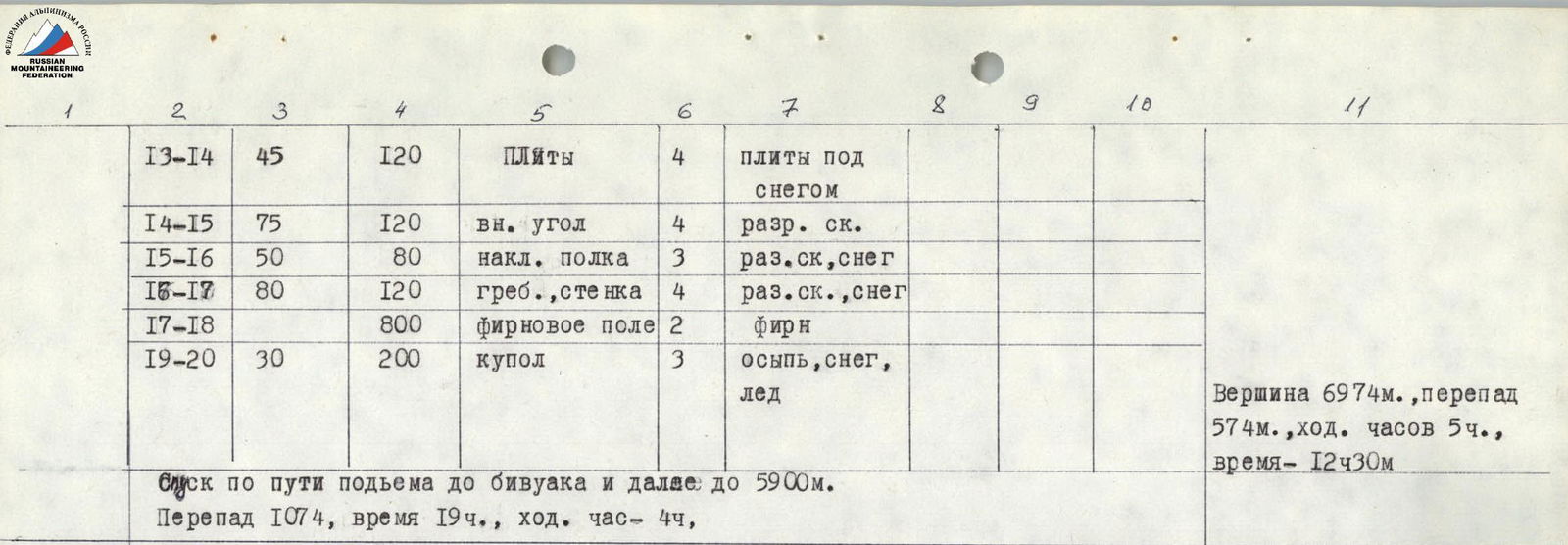
| Date | Section | Avg. Steepness | Length, m | Terrain Character | Diff. Cat. | Condition | Weather | Rock Pitons | Ice Pitons | Notes |
|---|---|---|---|---|---|---|---|---|---|---|
| July 31 | R0–R1 | 50° | 5 | Bergschrund | 3 | ice | good | 1 | Departure at 6:30, 5200 m. | |
| R1–R2 | 50° | 120 | Ice slope | 4 | ice | 2 | ||||
| R2–R3 | 50° | 40 | Ice slope | 4 | ice | 2 | ||||
| R3–R4 | 50° | 240 | Ridge | 5 | destroyed rocks | 6 | ||||
| R4–R5 | 50° | 120 | Ridge | 3 | snow, ice, destroyed rocks | 1 | ||||
| R5–R6 | 50° | 40 | Slope | 3 | soft snow on "ram's foreheads" | |||||
| R6–R7 | 50° | 160 | Ridge | 4 | snow-ice | 3 | ||||
| R7–R8 | 50° | 160 | Ridge, ice-rock | 5 | hard ice, destroyed rocks | 5 | ||||
| R8–R9 | 50° | 240 | Ridge | 5 | destroyed rocks | 5 | Height difference 1200 m, 13 climbing hrs, altitude 6400 m. | |||
| Aug 1 | R9–R10 | 40° | 160 | Ridge | 2 | rocks under snow | Departure at 7:30, 6400 m. | |||
| R10–R11 | 80° | 40 | Wall | 5 | internal angle | 4 | ||||
| R11–R12 | 80° | 20 | Chimney with a plug | 5 | destroyed rocks | 1 | ||||
| R12–R13 | 40° | 160 | Ridge | 2 | destroyed rocks under snow | |||||
| R13–R14 | 45° | 120 | Slabs | 4 | slabs under snow | |||||
| R14–R15 | 75° | 120 | Internal angle | 4 | destroyed rocks | |||||
| R15–R16 | 50° | 80 | Inclined ledge | 3 | destroyed rocks, snow | |||||
| R16–R17 | 80° | 120 | Ridge, wall | 4 | destroyed rocks, snow | |||||
| R17–R18 | 800 | Firn field | 2 | firn | ||||||
| R18–R19 | 30° | 200 | Dome | 3 | scree, snow, ice | Summit 6974 m, height difference 574 m, 5 climbing hrs, 12:30 |
August 2: Descent to base camp. Height difference 5900-4500-4700-4200-4400-4300-5200-3700 m. Departure at 7:00, arrival at base camp - 20:30, climbing hours - 10 hrs 30 min.
Height difference from bergschrund to summit - 1700 m. Number of climbing hours from camp to summit - 39 hrs, from bergschrund - 18 hrs, from camp to camp - 51 hrs. Average steepness of counterfort - 50°. Pitons driven for belaying: rock - 30 pcs., ice - 7 pcs. Number of overnight stays - 5 in convenient locations. Section lengths: 2nd diff. cat. - 120 m, 3rd diff. cat. - 525 m, 4th diff. cat. - 520 m, 5th diff. cat. - 700 m.