Ascent Passport
-
Ascent class: high-altitude
-
Ascent area, ridge: Pamir, Yazgulemsky Ridge.
-
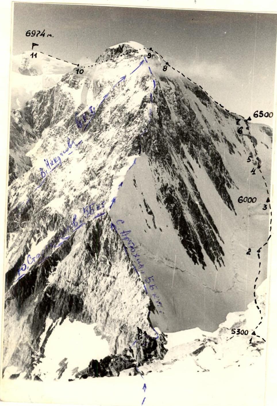
Peak, its height, ascent route: Peak Oktyabrskoy Revolyutsii, 6974 m, via the right part of the southeast wall, from the Khabarvin-khach glacier.
-
Proposed difficulty category: 5B.
-
Route characteristics:
height difference: about 2400 m, length of sections with 5–6 difficulty category: 700 m, average steepness: 45°
-
Pitons hammered: for belay — rock 12, ice 34, bolted —; for support — rock —, ice 7, bolted —.
-
Number of climbing hours: 44 hours
-
Number of bivouacs, their characteristics: 4 bivouacs on the route, all on snow and ice.
-
Leader: Zaydler A.M., Master of Sport
Participants: Pechenin V.M., Master of Sport. Lyashenko A.M., Candidate Master of Sport. Akselrod E.L., Candidate Master of Sport. Shcherbak E.V., Candidate Master of Sport. Kotlyarevsky V.E., 1st sports category.
-
Team coach: Zaydler A.M.
-
Departure from base camp: July 26, 1979
Return to base camp: August 2, 1979
Route of the first ascent via the right part of the southeast wall of Peak Revolyutsii, July 26 – August 2, 1979
1. Brief characteristics of the ascent area. History of exploration.
The Yazgulemsky Ridge is a powerful mountain range of tectonic origin, stretching in the latitudinal direction in the very center of the Pamir. Its eastern part, about 42 km long, borders the upper reaches of the Fedchenko and Grum-Grzhimailo glaciers from the south.
The Yazgulemsky Ridge serves as a watershed for the Bartang, Yazgulem, and Muk-su rivers. In the upper reaches of the Fedchenko glacier, the northern slopes of the ridge rise with a steep snow-ice wall with a relative height of 1–1.5 km, the southern slopes are rock-ice walls with a relative height of 2.5–3 km.
Peak Revolyutsii (6974 m) is the highest point of the Yazgulemsky Ridge and is located in its eastern part at the junction of the Fedchenko, Grum-Grzhimailo, Yazgulem-dara, and Khabarvin-khach glaciers.
The prevailing northeastern and northern winds have caused powerful glaciation of Peak Revolyutsii from the side of the Fedchenko and Grum-Grzhimailo glaciers. Towards the Yazgulem-dara and Khabarvin-khach glaciers, the massif breaks off with grandiose southwest and southeast walls, having relatively less glaciation.
Due to its geographical location and the nature of its slopes, Peak Revolyutsii is one of the most inaccessible peaks in our country.
Despite being discovered and named by N.V. Krylenko in 1929, the first ascent to it was made only in 1954 by participants in the VTsSPS expedition led by A. Ugarov. Then routes were laid:
- from the northeast (1960, led by Savvin S.M.),
- from the north from the Fedchenko glacier (1962, led by L. Myshlyaev),
- from the southwest and south (1968, led by V. Nekrasov and others) from the Yazgulem-dara valley.
The ascent from the southeast, from the inaccessible Khabarvin-khach valley, remained a mystery for climbers.
Therefore, the task of the Dnipropetrovsk climbers — to pioneer a route to the summit of Peak Revolyutsii from this valley — was extremely interesting and, at the same time, extremely difficult and responsible.
2. Brief description of the approach to the route
The expedition's base camp was located above the tongue of the Yazgulem-dara glacier, on the right orographically, at a height of about 3700 m. The climbers traveled by car on July 5 from the city of Osh to Lake Kara-Kul, then along the Kudara river valley to the Sovnob village, from where the loads were transferred to the base camp by their own efforts by July 15.
The approach from the base camp to the start of the route to Peak Revolyutsii takes two days (July 26–27, 1979) and includes an ascent to the Shipka pass (5300 m), a descent from it on fixed ropes about 150 m, and then a steep descent to the upper reaches of one of the western tributaries of the Khabarvin-khach glacier. Crossing the tributary, again an ascent, this time through an icefall from the spur of Peak Shipka, to the ridge of the spur, over which it is necessary to organize a descent along steep rocks and ice to the upper reaches of the next tributary of the glacier. Here, in a safe place from ice avalanches, at a height of about 4600 m on the ice, a bivouac is organized for further movement up to Peak Revolyutsii.
It should be taken into account that multi-tiered hanging glaciers and cornices overhang the upper reaches of both tributaries from the slopes, and ice avalanches are very possible, so movement should be carried out only in the early morning hours! Ice and rock pitons should be carried several pieces each, and crampons should be worn by everyone.
3. Table
of the main characteristics of the ascent route.
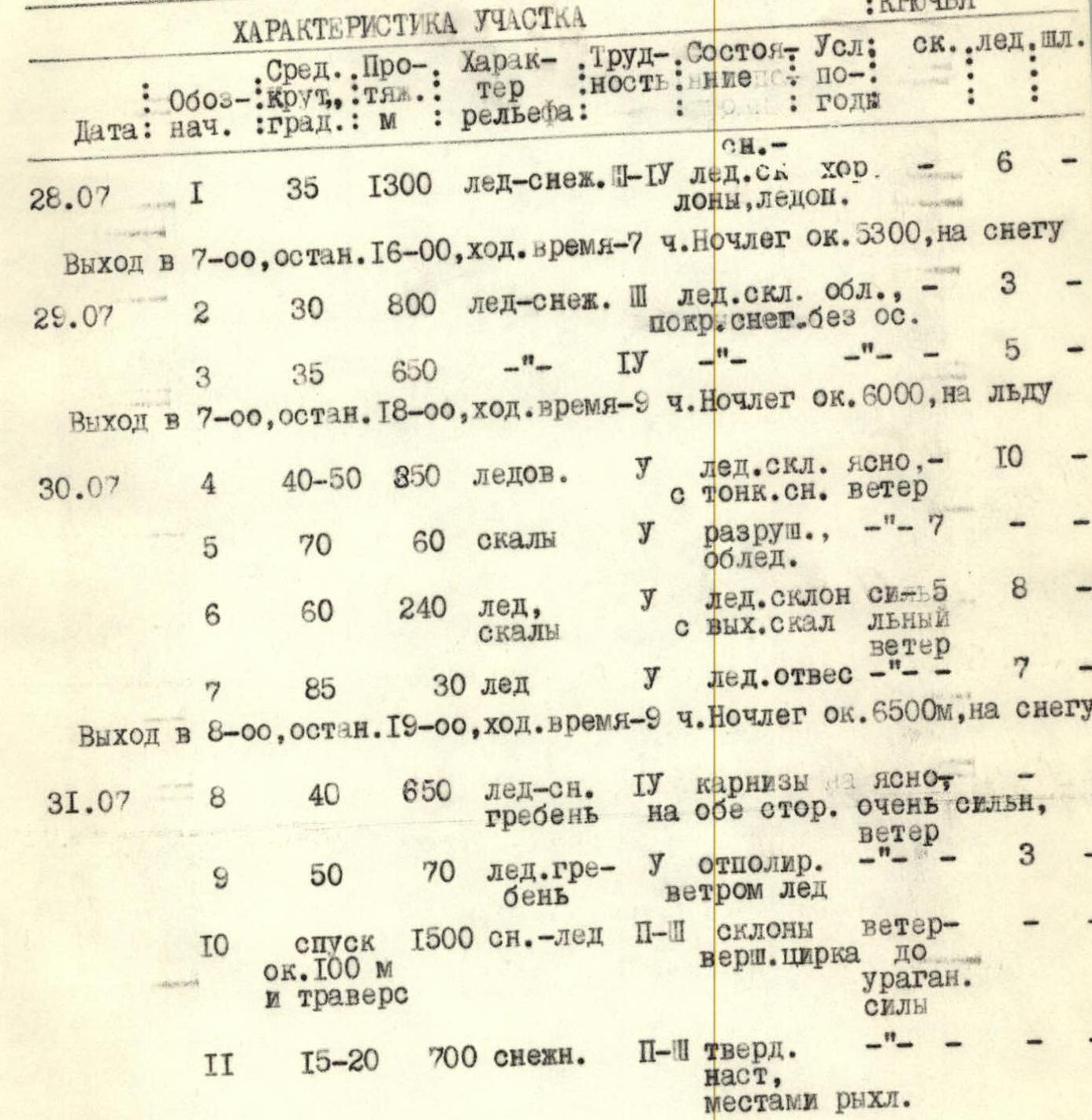
| Start date | Section | Average steepness, degrees | Length, m | Terrain character | Difficulty | Condition | Weather conditions | Pitons: rock | Pitons: ice | Pitons: bolted |
|---|---|---|---|---|---|---|---|---|---|---|
| July 28 | R1 | 35 | 1300 | ice-snow | III–IV | ice slope | clear | 6 | – | – |
| July 29 | R2 | 30 | 800 | ice-snow | III | ice slope, iced, covered with snow, no precipitation | 3 | – | – | |
| R3 | 35 | 650 | ice-snow | IV | – | – | 5 | – | – | |
| July 30 | R4 | 40–50 | 350 | ice | V | ice slope | clear, with thin snow, wind | 10 | – | – |
| R5 | 70 | 60 | rocks | V | destroyed | – | 7 | – | – | |
| R6 | 60 | 240 | ice, rocks with outcrops | V | ice slope | strong wind | 8 | 5 | – | |
| R7 | 85 | 30 | ice | V | ice sheer | – | 7 | – | – | |
| July 31 | R8 | 40 | 650 | ice-snow ridge | IV | cornices on both sides | clear, very strong wind | – | – | – |
| R9 | 50 | 70 | ice ridge | V | ice polished by wind | – | 3 | – | – | |
| R10 | – | 100 | descent, traverse, snow-ice | II–III | slopes of the summit cirque | wind up to hurricane force | – | – | – | |
| R11 | 15–20 | 700 | snow | II–III | hard snow crust, partially loose | – | – | – | – |
Descent via the ascent route, to the bivouac at 6500 m. Departure at 8:00, stop at 20:00, climbing time — 10 hours.
August 1. Descent via the ascent route to the bivouac at 4600 m under the Shipka pass.
4. Explanations for the table
Section R1 represents an ascent along a steep glacier and icefalls from the "4600" bivouac to the cirque under the southeast wall of Peak Revolyutsii, where the "5300" bivouac is organized. Movement is always in crampons, with many crevasses, and occasional small ice walls requiring piton belays.
Section R2 — ascent through a snow-ice mulde between the southeast wall of Peak Revolyutsii and the southwest wall of Peak Tumanny. The mulde has several drop-off steps-icefalls, where step-cutting is required, and occasional pitons.
Section R3 — the upper, steeper part of the mulde. Here, there is more belaying with ice pitons on breaks. Great danger of ice avalanches from Peak Revolyutsii! Bivouac with a cut-out platform before ascending to the ridge, height about 6000 m.
Section R4 — ice slope, the lower part of the ascent to the ridge. Movement in crampons with piton belays, towards the first rock island. When approaching the rocks, the ice is of a "flowstone" type, flaking off.
Section R5 — passage of the rock island. The rocks are heavily destroyed, with a great danger of stone fall on those below. Reliable belay only from the top of the island. The first person ascends without a backpack.
Section R6 — movement along an indistinct ridge, with outcrops of destroyed rocks under thin ice. The section is tense, with movement on front points, the first person is unloaded from the backpack to increase the reliability of movement, as the belay is unreliable. Strong cold wind from the ridge greatly hampers movement.
Section R7 — exit to the ridge along steep ice, almost sheer, using ice pitons for support. Bivouac on the ridge, height about 6500 m.
Section R8 — overcoming the rises of the snow-ice ridge. Complicated by the great steepness of the slopes on both sides and cornices. Movement from the bivouac without backpacks, in crampons, with careful belaying over the ridge, occasionally on pitons. Very strong wind from the Grum-Grzhimailo valley.
Section R9 — the upper, steeper part of the ridge, representing an ice slope leading to the ridge between the south and east summits of Peak Revolyutsii. Height around 6850–6900 m. From a cairn on the ridge, we remove a note from S. Savvon's group dated August 25, 1960, who ascended here via the east ridge from the Grum-Grzhimailo glacier (5B category).
Section R10 — descent into the summit cirque and traverse under the east summit of Peak Revolyutsii in the direction to the right of the main (north) summit.
Section R11 — ascent along a snow (firn) slope to the summit. Descent via the ascent route, with a bivouac in the "6500" camp.

Photo 2. View of the central part of the southeast wall of Peak Revolyutsii (below — the saddle to Peak Shipka and the Yazgulem-Dara valley).